Attachments 11.4 and 11.5 - City of Busselton
Attachments 11.4 and 11.5 - City of Busselton
Attachments 11.4 and 11.5 - City of Busselton

Create successful ePaper yourself
Turn your PDF publications into a flip-book with our unique Google optimized e-Paper software.
LAND inSights<br />
ATTACHMENT A – DRAFT LEPS ITEM <strong>11.5</strong> COUNCIL 12/10/2011<br />
Executive Summary<br />
1.2 Study Area<br />
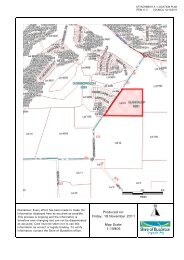
The Study Area comprises the entire Shire <strong>of</strong> <strong>Busselton</strong> municipal area. It is bound to the north<br />
by the Shire <strong>of</strong> Capel, to the east by the Shire <strong>of</strong> Donnybrook-Balingup <strong>and</strong> to the south by the<br />
Shire <strong>of</strong> Augusta-Margaret River <strong>and</strong> the Shire <strong>of</strong> Nannup. The extent <strong>of</strong> the Shire’s<br />
boundaries is shown in Figure 1.1.<br />
The Shire covers an area <strong>of</strong> 145 500 hectares on the west coast <strong>of</strong> Western Australia,<br />
approximately 220 kilometres south <strong>of</strong> Perth. It has a population <strong>of</strong> approximately 32,000<br />
people 1 . The towns <strong>of</strong> <strong>Busselton</strong> <strong>and</strong> Dunsborough are the principal settlements <strong>and</strong> together<br />
with Yallingup, as well as Cape Naturaliste <strong>and</strong> the west coast are popular tourist destinations<br />
for recreational activities such as swimming, boating <strong>and</strong> fishing in association with the Shire’s<br />
wine <strong>and</strong> food industry. The central area <strong>of</strong> the Shire is primarily used for agricultural<br />
purposes, <strong>and</strong> is largely cleared <strong>of</strong> vegetation. The western coastal areas, the west coast <strong>and</strong><br />
a large area <strong>of</strong> l<strong>and</strong> at the eastern end <strong>of</strong> the Shire are largely reserved for conservation <strong>and</strong>/or<br />
recreation purposes.<br />
1.3 Scope <strong>of</strong> this report<br />
This report presents the findings <strong>and</strong> recommendations <strong>of</strong> the Local Environmental Planning<br />
Strategy. It builds on the background information provided in previous reports, notably:<br />
• Report 1 – Environmental Pr<strong>of</strong>ile<br />
• Report 2 – Spatial Planning Units (unpublished internal background document).<br />
Background information pertaining to the environmental features <strong>of</strong> the Shire is contained<br />
within these two reports. This information, along with the significant consultation that has<br />
occurred, has provided the context to the strategies <strong>and</strong> actions presented in this document.<br />
Numerous planning <strong>and</strong> environmental policies <strong>and</strong> reports exist which are applicable to the<br />
Shire <strong>and</strong> help guide development <strong>and</strong> l<strong>and</strong> use. These have been looked at in detail in Report<br />
1. Updated policies <strong>and</strong> information should be considered in conjunction with the outcomes <strong>of</strong><br />
this report when necessary.<br />
The format <strong>of</strong> this document has been derived to provide the Shire with guidance on key<br />
environmental matters relating to development <strong>and</strong> l<strong>and</strong> use planning. More specific<br />
consideration has also been provided for areas where development pressures are expected to<br />
be greatest – <strong>Busselton</strong>, Vasse, Dunsborough <strong>and</strong> Commonage.<br />
Within each section <strong>of</strong> the report consideration has been given to what the desired<br />
environmental outcomes are <strong>and</strong> how these can be achieved through the l<strong>and</strong> use planning<br />
system. The intention is that the objectives <strong>and</strong> actions for specific environmental issues in the<br />
Shire be considered in conjunction with, or complement, the actions which are specific to the<br />
settlements <strong>and</strong> towns in the Shire as well as recommended changes <strong>and</strong> the TPS zones <strong>and</strong><br />
reserves.<br />
1 ERP, 2010 Australian Bureau <strong>of</strong> Statistics<br />
VER 1 – FINAL DRAFT<br />
Shire <strong>of</strong> <strong>Busselton</strong> Local Environmental Planning Strategy<br />
Report 3 – Objectives, Strategies <strong>and</strong> Actions<br />
November 2010<br />
Page 20