Attachments 11.4 and 11.5 - City of Busselton
Attachments 11.4 and 11.5 - City of Busselton
Attachments 11.4 and 11.5 - City of Busselton

Create successful ePaper yourself
Turn your PDF publications into a flip-book with our unique Google optimized e-Paper software.
ATTACHMENT A - MACROPHYTE PROPOSAL<br />
ITEM <strong>11.4</strong> COUNCIL 12/10/2011<br />
Lower Vasse River Macrophyte Project: Effectiveness <strong>of</strong> submerged macrophytes in<br />
reducing phytoplankton growth<br />
Introduction<br />
The Shire <strong>of</strong> <strong>Busselton</strong> is considering the use <strong>of</strong> restored submerged macrophytes to address water quality<br />
problems in the Lower Vasse River. This method has the potential to achieve water quality improvement, as<br />
well as enhancing ecological function, however it is a new technique which is best undertaken as a restoration<br />
<strong>and</strong> research project.<br />
Robyn Paice, who has previously done an honours research project on establishing macrophytes in the Lower<br />
Vasse River (Paice, 2009), has been <strong>of</strong>fered a scholarship through Murdoch University to undertake a PhD that<br />
would investigate the potential for macrophytes to reduce phytoplankton growth <strong>and</strong> examine their influence<br />
on nutrient dynamics <strong>and</strong> ecology. Benefits <strong>of</strong> this approach are considerably lower project costs (detailed<br />
below), <strong>and</strong> excellent information outcomes.<br />
This report provides a draft outline for a combined research <strong>and</strong> restoration project in the Lower Vasse River<br />
that would result in both direct action in the Lower Vasse River <strong>and</strong> important research outcomes. It is a basis<br />
for discussion <strong>and</strong> project development.<br />
Background<br />
Submerged macrophytes have an important role in maintaining water clarity in wetl<strong>and</strong> systems, <strong>and</strong> at low<br />
levels <strong>of</strong> nutrient enrichment, their presence can prevent a shift to a turbid, phytoplankton‐dominated state<br />
(Scheffer, 2004). There has been much research regarding the mechanisms by which macrophyte maintain a<br />
clear‐water state, which include:<br />
• enhanced top‐down control <strong>of</strong> phytoplankton by grazing zooplankton;<br />
• sediment trapping <strong>and</strong> reduced resuspension;<br />
• alterations to nutrient cycling <strong>and</strong> availability, including competition with phytoplankton;<br />
• shading; <strong>and</strong><br />
• possible effects <strong>of</strong> allelopathy.<br />
(Søndergaard <strong>and</strong> Moss, 1998; Stephen et al., 1998; Jeppesen et al., 1999).<br />
Despite their important role, there has been little research into the benefits <strong>of</strong> macrophyte restoration.<br />
Restoration <strong>of</strong> macrophytes is difficult in nutrient‐enriched systems due to light limitations caused by dense<br />
growth <strong>of</strong> phytoplankton <strong>and</strong> epiphytes.<br />
Previous research in the Lower Vasse River has demonstrated that the submerged macrophyte Vallisneria<br />
australis can be grown successfully in conditions <strong>of</strong> high turbidity <strong>and</strong> phytoplankton (Novak <strong>and</strong> Chambers<br />
2005; Paice, 2009). V. australis grown in a meadow situation was found to substantially increase aquatic<br />
invertebrate abundance <strong>and</strong> diversity, <strong>and</strong> sustain a more consistent zooplankton population (Paice, 2009).<br />
In terms <strong>of</strong> water quality, the meadow trials in 2007‐08 were too small to determine any measurable<br />
improvement. However the meadows did appear to trap particulate materials, indicating increased<br />
sedimentation <strong>and</strong> reduced resuspension which could potentially contribute to improved water quality (Paice,<br />
2009). A larger macrophyte meadow was established in 2009 upstream <strong>of</strong> the <strong>Busselton</strong> Bypass, <strong>and</strong> water<br />
quality monitoring has indicated lower phosphorus concentrations <strong>and</strong> lower turbidity in the meadow<br />
compared to adjacent open waters (Murdoch University, unpublished data).
ATTACHMENT A - MACROPHYTE PROPOSAL<br />
ITEM <strong>11.4</strong> COUNCIL 12/10/2011<br />
This project investigates whether a macrophyte that tolerates high nutrient <strong>and</strong> low light conditions be used to<br />
reinstate a macrophyte dominant regime. It will examine whether such established macrophyte beds coexist<br />
with algal blooms or whether, by the mechanisms outlined above, the macrophyte reduces phytoplankton<br />
growth <strong>and</strong>/or nutrient status <strong>of</strong> the water.<br />
Experimental Design<br />
While the potential <strong>of</strong> submerged macrophytes to improve water quality appears good, there is no guarantee<br />
that phytoplankton growth will be reduced. Research is needed to assess this outcome <strong>and</strong> also to improve<br />
underst<strong>and</strong>ing <strong>of</strong> nutrient dynamics <strong>and</strong> trophic interactions within the restored macrophyte beds.<br />
Experimental design needs to allow for detailed monitoring <strong>and</strong> analysis to meet these research objectives.<br />
The project will involve establishment <strong>of</strong> replicate submerged macrophyte meadows within protective cages to<br />
prevent disturbance by birds (<strong>and</strong> possibly by large goldfish). The design <strong>of</strong> the cages is negotiable, providing<br />
that they allow sufficient protection <strong>and</strong> ongoing access for monitoring. The design <strong>and</strong> costs described here<br />
are based on the existing meadow upstream <strong>of</strong> the <strong>Busselton</strong> Bypass. This uses 50mm weld mesh <strong>and</strong> star<br />
pickets to create a fence around the meadow, with bird netting placed over the top.<br />
Macrophyte transplants are attached to 100mm weld mesh which is lowered to the sediment surface. This<br />
gives the plants a substrate for growth, as the sediments are very flocculent <strong>and</strong> cannot be planted into. The<br />
mesh is help in place by star pickets, which also hold the bird netting up to prevent it from sagging into the<br />
water.<br />
The submerged macrophyte Vallisneria australis would be used for the project, as this has been found to<br />
tolerate the turbid, nutrient‐enriched conditions in the Lower Vasse River. It is native to Western Australia,<br />
although there is some debate as to its natural extent. The transplants used have been grown from plants<br />
sourced in the Margaret River.<br />
Figure 1 depicts the construction <strong>of</strong> the macrophyte meadows, <strong>and</strong> Figure 2 shows the meadow established<br />
using this method in 2009. To allow statistical analysis <strong>of</strong> data, five replicate meadows would be required. The<br />
existing meadow upstream <strong>of</strong> the bypass can be incorporated into the project, so an additional four meadows<br />
would need to be constructed.<br />
In determining the size, design <strong>and</strong> location <strong>of</strong> macrophyte meadows, consideration needs to be given to:<br />
• the size required to effectively measure any benefits;<br />
• the public pr<strong>of</strong>ile <strong>of</strong> the project;<br />
• the visual amenity <strong>of</strong> meadows <strong>and</strong> protective cages; <strong>and</strong><br />
• the cost <strong>of</strong> establishing the meadows <strong>and</strong> protective cages.<br />
For any visual <strong>and</strong> measurable results it is recommended that meadows <strong>of</strong> at least 6m by 6m are used for the<br />
project, <strong>and</strong> it is possible to create larger meadows if desired.
ATTACHMENT A - MACROPHYTE PROPOSAL<br />
ITEM <strong>11.4</strong> COUNCIL 12/10/2011<br />
bird netting over enclosure<br />
outside fence <strong>of</strong><br />
50mm weld mesh<br />
supported by<br />
180mm star pickets<br />
100mm weld mesh grid<br />
2.0x1.2m with transplants laid<br />
on top <strong>of</strong> sediments, held in<br />
pace with a 2.4m star picket,<br />
which also holds up bird netting<br />
Figure 1. Diagram <strong>of</strong> macrophyte meadow establishment within protective enclosure.<br />
Figure 2. Photo <strong>of</strong> macrophyte meadow enclosure in the Lower Vasse River upstream <strong>of</strong> <strong>Busselton</strong> Bypass, established in<br />
October 2009 (photo taken May 2011).<br />
Monitoring requirements<br />
It is proposed that monitoring be undertaken at least monthly, in each <strong>of</strong> five meadow <strong>and</strong> at five control sites<br />
in adjacent open waters, from November to April for three years <strong>and</strong> include the following:<br />
• Collection <strong>of</strong> samples for nutrient analysis;<br />
• In situ measurement <strong>of</strong> physicochemical parameters;<br />
• Collection <strong>of</strong> invertebrate sweep samples for identification <strong>and</strong> counting; <strong>and</strong><br />
• Collection <strong>of</strong> plant material for analysis <strong>of</strong> epiphyte load <strong>and</strong> plant growth.
ATTACHMENT A - MACROPHYTE PROPOSAL<br />
ITEM <strong>11.4</strong> COUNCIL 12/10/2011<br />
The costs in Table 1 are based on this regime. Additional funding would allow more extensive investigation<br />
such as analysis <strong>of</strong> additional parameters, phytoplankton identification <strong>and</strong> density analysis, <strong>and</strong> sediment<br />
investigations. It would also allow for development <strong>of</strong> laboratory trials to investigate specific chemical <strong>and</strong><br />
biological interactions.<br />
Project Costs<br />
The main project costs are materials for construction <strong>of</strong> protective cages, sample analysis costs, <strong>and</strong> labour<br />
costs associated with establishing the cages <strong>and</strong> meadows, undertaking monitoring <strong>and</strong> completing data<br />
analysis <strong>and</strong> reporting. The cost <strong>of</strong> the project <strong>and</strong> contributions from various organisations will vary<br />
depending on how it proceeds, however joint funding is likely to be sought from the Shire <strong>of</strong> <strong>Busselton</strong>,<br />
Murdoch University <strong>and</strong> GeoCatch.<br />
While the project is still in the development stage, indicative costs are outlined in Table 1 below. It is evident<br />
from this table that there is potential for considerable cost savings if the project were undertaken for PhD<br />
research purposes. It should be noted that the monitoring requirements included here are based on meeting<br />
research outcomes.<br />
Table 1. Indicative costs for macrophyte restoration research project.<br />
Item description Cost per unit Number Total cost Cost as PhD project<br />
Cage construction<br />
6 x 6m $800 4 $3600 $3600<br />
10 x 10m $1400 4 $5600 $5600<br />
Plants $1000 $1000<br />
Labour $100/hr (2 people) 12hrs $1200 ‐<br />
Monitoring*<br />
Sampling labour $100/hr (2 people) 7hrs/mth x $4200 per year ‐<br />
6mths<br />
Water quality analyses $130/sample 60 samples $7800 per year $4680<br />
(40% discount)<br />
Invertebrate <strong>and</strong> plant<br />
analyses<br />
$240/sample (3hrs<br />
@$80/hr)<br />
60 samples $14400 per year ‐<br />
Data analysis <strong>and</strong> reporting $80/hr Production <strong>of</strong><br />
published<br />
annual report,<br />
approx 80 hours<br />
$6400 Thesis produced with<br />
interim annual<br />
reporting at no cost.<br />
*Monitoring intensity <strong>and</strong> suit <strong>of</strong> parameters may differ if project is not used for PhD research. Amounts are annual costs<br />
with monitoring expected to continue for 3 years.<br />
Summary<br />
The opportunity exists to develop a combined restoration <strong>and</strong> research project for the establishment <strong>of</strong><br />
submerged macrophytes in the Lower Vasse River to address problems <strong>of</strong> excessive phytoplankton growth.<br />
The project would increase underst<strong>and</strong>ing <strong>of</strong> the mechanisms by which macrophytes influence nutrient<br />
dynamics, trophic structure <strong>and</strong> ecosystem function. This information will assist in management <strong>of</strong> nutrient<br />
enriched waterways, <strong>and</strong> may provide an important tool for improving water quality.
ATTACHMENT A - MACROPHYTE PROPOSAL<br />
ITEM <strong>11.4</strong> COUNCIL 12/10/2011<br />
References<br />
Jeppesen, E., Jensen, J. P., Søndergaard, M. Lauridsen, T. (1999). Trophic dynamics in turbid <strong>and</strong><br />
clearwater lakes with special emphasis on the role <strong>of</strong> zooplankton for water clarity. Hydrobiologia<br />
408/409: 217‐231<br />
Novak, P. <strong>and</strong> Chambers, J. (2005) Rehabilitation <strong>of</strong> submerged macrophytes into the Canning River<br />
<strong>and</strong> Lower Vasse River, Western Australia: Determining thresholds <strong>of</strong> phosphorus concentration,<br />
epiphyte load <strong>and</strong> phytoplankton as barriers to macrophyte restoration. Environmental Science,<br />
Murdoch University: Perth.<br />
Paice, R. L. (2009) Restoration <strong>of</strong> Submerged Macrophytes in the Lower Vasse River: Feasibility <strong>and</strong><br />
Potential Benefits. Honours thesis, Environmental Science, Murdoch University.<br />
Scheffer, M. (2004) Ecology <strong>of</strong> Shallow Lakes. Kluwer Academic Publishers: The Netherl<strong>and</strong>s.<br />
Søndergaard, M. <strong>and</strong> Moss, B. (1998). Impact <strong>of</strong> Submerged macrophytes on Phytoplankton in<br />
Shallow Freshwater Lakes. Pages 115‐132 in E. Jeppesen, M. Søndergaard, <strong>and</strong> K. Christ<strong>of</strong>ferson, eds.<br />
The Structuring Role <strong>of</strong> Submerged Macrophytes in Lakes. Springer‐Verlang: New York.<br />
Stephen, D., Moss, B. <strong>and</strong> Phillips, G. (1998). The relative importance <strong>of</strong> top‐down <strong>and</strong> bottom‐up<br />
control <strong>of</strong> phytoplankton in a shallow macrophyte‐dominated lake. Freshwater Biology 39: 699‐713.
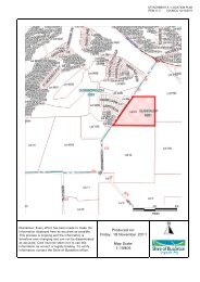
ATTACHMENT B - RIVERBANK REINSTATEMENT DESIGN<br />
ITEM <strong>11.4</strong> COUNCIL 12/10/2011<br />
N<br />
PEEL TERRACE<br />
GRASS<br />
COARSE SAND<br />
PLANTING<br />
SEE DETAIL A<br />
PLANTING<br />
VASSE<br />
PEDESTRIAN BRIDGE<br />
TO BE UPGRADED 2007<br />
RIVER<br />
CAUSEWAY ROAD<br />
10 5 0 10 20 30 m<br />
SCALE 1: 500<br />
PLAN VIEW<br />
1<br />
0m<br />
AHD<br />
-1<br />
EXISTING EMBANKMENT<br />
SAWDUST/ LIMESTONE<br />
( EQUAL PORTIONS)<br />
PAPERBARKS<br />
SEDGES<br />
SAND INFILL<br />
LIMESTONE RUBBLE<br />
SLOPE 1:3<br />
LIMESTONE RUBBLE<br />
HWM 0.8<br />
AWM 0.3<br />
LWM -0.3<br />
GL<br />
GRASS TO AVERAGE WATER MARK<br />
HWM 0.8<br />
AWM 0.3<br />
LIMESTONE WEED BARRIER/ PATH LIMESTONE WEED BARRIER/ PATH<br />
COARSE SAND BEACH<br />
BELOW AVERAGE<br />
WATER LINE<br />
LIMESTONE RUBBLE<br />
PLANTING / FABRIC<br />
(A.W.M)<br />
(L.W.M)<br />
PLANTING / FABRIC<br />
-2<br />
0m 3 6 9 12<br />
DIST<br />
PROPOSED NORTH BANK CROSS SECTION<br />
DETAIL A<br />
ISSUE DATE GRID REVISION DRN REC APPD<br />
SURVEY<br />
BOOKS<br />
DATUM<br />
DES REF<br />
DES CHD<br />
DRN<br />
CBC 04/07<br />
NORTH POINT<br />
RECOMMENDED<br />
REC<br />
APPROVED<br />
APP<br />
SHIRE OF BUSSELTON<br />
PH: 97810444<br />
SHIRE OF BUSSELTON<br />
PROPOSED EMBANKMENT REPAIR & UPGRADE<br />
VASSE RIVER - NORTH EMBANKMENT<br />
SHEET 1 OF 1<br />
FILE PROJECT PLAN<br />
ENV1<br />
VRIVER 03-01<br />
CAD<br />
ISSUE<br />
A<br />
ORIGINAL<br />
SHEET<br />
SIZE<br />
MF<br />
F:\TECH SERVICES\ PLAN INDEX\ DRAINAGE\ VRIVER 03-01
ATTACHMENT C - TREATMENT OPTIONS CONSIDERED IN THE COUNCILLOR WORKSHOP OF MAY 2011<br />
ITEM <strong>11.4</strong> COUNCIL 12/10/2011<br />
1<br />
TREATMENT OPTIONS CONSIDERED IN THE COUNCILLOR WORKSHOP OF<br />
MAY 2011.<br />
This section provides brief discussion on the treatment options that were<br />
discussed during the workshop <strong>and</strong> why they were or were not considered<br />
for further investigation.<br />
Phoslock<br />
Phoslock is a modified clay, designed to reduce the release <strong>of</strong> phosphorus<br />
from sediments in waterways. It acts to permanently bind filterable reactive<br />
phosphorus (FRP), which is the type <strong>of</strong> phosphorous available to algae. By<br />
limiting the amount <strong>of</strong> phosphorus it is possible to prevent algal blooms from<br />
occurring or, at least, prevent them from progressing to the more harmful<br />
blue-green algal bloom condition.<br />
Phoslock is applied to the water by mixing into a slurry <strong>and</strong> spraying over<br />
the whole surface so that it covers all the sediments <strong>of</strong> the water body. As<br />
the Phoslock settles it removes Phosphorous from the water column. It then<br />
settles on the riverbed <strong>and</strong> acts as a reactive layer, intercepting any FRP<br />
that may be released by the sediment.<br />
The main benefit <strong>of</strong> Phoslock application is the permanent removal <strong>of</strong><br />
phosphorus that had accumulated in sediments. By so doing algal growth is<br />
limited for some time, in the order <strong>of</strong> weeks to months.<br />
However, it is less effective in reaction to a bloom event since much <strong>of</strong> the<br />
Phosphorus is bound up in algae <strong>and</strong> not available to the clay Phoslock<br />
treatment is relatively effective during summer unless summer rain occurs<br />
which delivers more P to the LVR from septage <strong>and</strong> surface run<strong>of</strong>f. It would<br />
be possible to undertake topical dosing <strong>of</strong> Phoslock after rain given the<br />
improvements in Phoslock packaging <strong>and</strong> delivery systems.. Applications<br />
<strong>of</strong> Phoslock are relatively expensive: up to $200,000 per application<br />
depending on area treated <strong>and</strong> number <strong>of</strong> treatments.<br />
Because there are inflows <strong>of</strong> nutrient to the river from surface run-<strong>of</strong>f <strong>and</strong><br />
groundwater, stopping the nutrient from the sediments will not prevent algal<br />
blooms from occurring <strong>and</strong> therefore the application <strong>of</strong> Phoslock would need<br />
to be ongoing. Operationally on full dosing <strong>of</strong> between 40 <strong>and</strong> 60 tonnes<br />
would be applied in the first year with smaller dosings <strong>of</strong> 10 to 20 tonnes in<br />
subsequent years.<br />
Until control <strong>of</strong> Phosphorus sources such as septage, agricultural run<strong>of</strong>f <strong>and</strong><br />
industrial <strong>and</strong> residential run<strong>of</strong>f all treatments <strong>of</strong> the LVR to manage algal<br />
blooms will be ongoing including Phoslock however in the case <strong>of</strong><br />
Phoslock the costs are minimised by the treatment sequence described<br />
above.<br />
On that basis Phoslock was a lower priority option for treatment.<br />
Algal flocking materials
ATTACHMENT C - TREATMENT OPTIONS CONSIDERED IN THE COUNCILLOR WORKSHOP OF MAY 2011<br />
ITEM <strong>11.4</strong> COUNCIL 12/10/2011<br />
2<br />
Another approach completely is to physically sink the algae to the bottom <strong>of</strong><br />
the river through the use <strong>of</strong> flocculating clays <strong>and</strong> other materials. In fact<br />
one such trial <strong>of</strong> a prospective material has already been trialled on the LVR.<br />
These methods rely on the added material to bind together the algal cells so<br />
that they become heavier <strong>and</strong> sink. Much work has been conducted<br />
overseas mainly on din<strong>of</strong>lagellate phytoplankton <strong>and</strong> relatively little on blue<br />
green algae which are the main LVR Phytoplankton type.<br />
Research in China has shown that Loess clays can remove algae <strong>and</strong> that<br />
clays mixed with Chitonase are especially effective.<br />
Chitonase is a natural product made from ground up mollusc shells. All <strong>of</strong><br />
these products only remove algae from the surface to the bottom. However<br />
when the algal cells breakdown the nutrient is released <strong>and</strong> again becomes<br />
available for algal growth. This treatment therefore also needs to be used in<br />
conjunction with another product, such as Phoslock, that binds the<br />
phosphorous so it is not available.<br />
Chitonase is currently quite expensive. The price has been driven up by it’s<br />
medicinal uses.<br />
Algal removal for the LVR<br />
Another approach is to physically remove the algae from the river which is<br />
difficult given the buoyant nature <strong>of</strong> the blue greens involved. During the<br />
Jan 2000 algal bloom in the Swan suction trucks were effectively used to<br />
remove algae, which was then transported to a Water corporation Waste<br />
water treatment facility. The technique works because the buoyant algae<br />
floats to the surface in the vacuum truck <strong>and</strong> the algae clear water can be<br />
decanted from the bottom which reduces the number <strong>of</strong> truck journeys<br />
required.<br />
The disadvantage is that once the algae is removed more will grow due to<br />
the abundant supply <strong>of</strong> phosphorus <strong>and</strong> so treatments <strong>of</strong> Phoslock would<br />
also be required. The advantage <strong>of</strong> physical removal is that both nutrients<br />
<strong>and</strong> organic sludge are removed from the system. This option has not been<br />
costed <strong>and</strong> would depend on disposal at Water Corporation site <strong>and</strong><br />
availability <strong>of</strong> vacuum trucks.<br />
Nutrisorb<br />
Nutrisorb is a by-product <strong>of</strong> the mineral s<strong>and</strong>s industry produced by Iluka. It<br />
has very good physical filtration properties <strong>and</strong> therefore is thought to be a<br />
good treatment to use within the catchment close to the source <strong>of</strong> the<br />
pollutants. For example, it could be used as a soil amendment around point<br />
sources such as dairy effluent ponds <strong>and</strong> paddocks where the effluent is<br />
disposed <strong>of</strong>, or diffuse sources such as paddocks as a top dressing which<br />
prevents nutrients from getting into creek lines.
ATTACHMENT C - TREATMENT OPTIONS CONSIDERED IN THE COUNCILLOR WORKSHOP OF MAY 2011<br />
ITEM <strong>11.4</strong> COUNCIL 12/10/2011<br />
3<br />
Use <strong>of</strong> nutrisorb to filter nutrients from the lower Vasse River in situ would<br />
require costly engineering processes to recirculate the water through pumps,<br />
filters <strong>and</strong> pipes <strong>and</strong> replace the filter medium on a regular basis as it<br />
became saturated. As this is not the intended application for this material it<br />
is not a good option for treatment <strong>of</strong> the Lower Vasse River.<br />
Bio-filtration<br />
Bio-filtration is the same process that is used for water Quality improvement<br />
<strong>of</strong> stormwater. The suggestion is that perhaps some <strong>of</strong> the bio-filtration<br />
basins that have been constructed for treatment <strong>of</strong> stormwater before it<br />
gets into the river in winter could be used for recirculation <strong>of</strong> the river water<br />
during summer.<br />
Bio-filtration uses soils <strong>and</strong> plants to take up the nutrients. Water entering<br />
the system is allowed to pass through the soil <strong>and</strong> plant roots giving them<br />
the opportunity to take up the nutrients. The soil medium takes most <strong>of</strong> the<br />
Phosphorous while the plants take out most <strong>of</strong> the Nitrogen. Excess water<br />
that is not transpired by the plants passes out the bottom <strong>of</strong> the system <strong>and</strong><br />
back into the river. Periodically the plants need to be harvested <strong>and</strong> the soil<br />
medium replaced to remove the nutrients from the system.<br />
The constructed wetl<strong>and</strong> at the end <strong>of</strong> Bunbury Street in the LIA has only<br />
recently been installed <strong>and</strong> will be monitored for its effectiveness to remove<br />
nutrient from winter run-<strong>of</strong>f. The potential to treat water from the river<br />
during summer should be investigated.<br />
Macrophytes<br />
Submerged macrophytes have an important role in maintaining water clarity<br />
in wetl<strong>and</strong> systems, <strong>and</strong> at low levels <strong>of</strong> nutrient enrichment, their presence<br />
can prevent a shift to a turbid, phytoplankton-dominated state (Scheffer,<br />
2004). There has been much research regarding the mechanisms by which<br />
macrophyte maintain a clear-water state, which include:<br />
• enhanced top-down control <strong>of</strong> phytoplankton by grazing<br />
zooplankton;<br />
• sediment trapping <strong>and</strong> reduced resuspension;<br />
• alterations to nutrient cycling <strong>and</strong> availability, including<br />
competition with phytoplankton;<br />
• shading; <strong>and</strong><br />
• possible effects <strong>of</strong> allelopathy.<br />
(Søndergaard <strong>and</strong> Moss, 1998; Stephen et al., 1998; Jeppesen et al.,<br />
1999).<br />
Despite their important role, there has been little research into the benefits<br />
<strong>of</strong> macrophyte restoration. Restoration <strong>of</strong> macrophytes is difficult in<br />
nutrient-enriched systems due to light limitations caused by dense growth <strong>of</strong><br />
phytoplankton <strong>and</strong> epiphytes.<br />
Previous research in the Lower Vasse River has demonstrated that the<br />
submerged macrophyte Vallisneria australis can be grown successfully in
ATTACHMENT C - TREATMENT OPTIONS CONSIDERED IN THE COUNCILLOR WORKSHOP OF MAY 2011<br />
ITEM <strong>11.4</strong> COUNCIL 12/10/2011<br />
4<br />
conditions <strong>of</strong> high turbidity <strong>and</strong> phytoplankton (Novak <strong>and</strong> Chambers 2005;<br />
Paice, 2009). V. australis grown in a meadow situation was found to<br />
substantially increase aquatic invertebrate abundance <strong>and</strong> diversity, <strong>and</strong><br />
sustain a more consistent zooplankton population (Paice, 2009).<br />
In terms <strong>of</strong> water quality, the meadow trials in 2007-08 were too small to<br />
determine any measurable improvement. However the meadows did appear<br />
to trap particulate materials, indicating increased sedimentation <strong>and</strong> reduced<br />
re-suspension which could potentially contribute to improved water quality<br />
(Paice, 2009). A larger macrophyte meadow was established in 2009<br />
upstream <strong>of</strong> the <strong>Busselton</strong> Bypass, <strong>and</strong> water quality monitoring has<br />
indicated lower phosphorus concentrations <strong>and</strong> lower turbidity in the<br />
meadow compared to adjacent open waters (Murdoch University,<br />
unpublished data).<br />
A new project is proposed to investigate whether macrophytes that tolerate<br />
high nutrient <strong>and</strong> low light conditions can be used to reinstate a macrophyte<br />
dominant regime. It will examine whether such established macrophyte beds<br />
coexist with algal blooms or whether, by the mechanisms outlined above,<br />
the macrophyte reduces phytoplankton growth <strong>and</strong>/or nutrient status <strong>of</strong> the<br />
water.<br />
Macrophytes have the potential to improve water quality, as well as<br />
enhance ecological function, however it is a new technique which is best<br />
undertaken as a restoration <strong>and</strong> research project. The attached report<br />
(Attachment A) provides a draft outline for a combined research <strong>and</strong><br />
restoration project in the Lower Vasse River that would result in both direct<br />
action in the Lower Vasse River <strong>and</strong> important research outcomes. It is a<br />
basis for discussion <strong>and</strong> project development. This macrophyte project is<br />
recommended for support by Council.<br />
Enzymes<br />
Enzymes are chemicals that occur in nature <strong>and</strong> include complex str<strong>and</strong>s <strong>of</strong><br />
protein that accelerate certain reactions. Enzymes will target different<br />
substrates in the water <strong>and</strong> bond with them, subsequently reducing them on<br />
a molecular level. Through this reaction they form harmless compounds that<br />
will have no further negative effect on the water. While enzymes are<br />
chemicals, they are comprised <strong>of</strong> commonly occurring amino acids <strong>and</strong> can<br />
be produced by certain bacteria. As they are chemical in nature, enzymes<br />
will not reproduce after being introduced to the water. So they are a single<br />
use product. The enzyme concentration in the water also stimulates any<br />
bacteria present to speed the biological degradation.<br />
One product, Soil-Zyme that has been used in large water bodies, in<br />
conjunction with AirDuck aerators to improve mixing, has been promoted to<br />
the Shire for use in the Vasse River. It is supposed to produce an 80% or<br />
more reduction <strong>of</strong> algae <strong>and</strong> algae blooms, eliminating Blue-green algae<br />
within 3-4 Days <strong>of</strong> application. A number <strong>of</strong> lakes are supposed to have<br />
been shown to have no further outbreaks after using the product.
ATTACHMENT C - TREATMENT OPTIONS CONSIDERED IN THE COUNCILLOR WORKSHOP OF MAY 2011<br />
ITEM <strong>11.4</strong> COUNCIL 12/10/2011<br />
5<br />
While this may be the case, its application to a large linear water body, such<br />
as the Lower Vasse River has not been proven. The risk associated with<br />
adding chemicals to a natural water body, as against an artificial lake, is a<br />
concern <strong>and</strong> has not quantified. There is no documentation on how it may<br />
affect the many parameters <strong>of</strong> water quality <strong>and</strong> therefore this treatment<br />
option is one that, needed the pro<strong>of</strong> <strong>of</strong> concept to be shown before it can<br />
be considered for use.<br />
If a supplier was prepared to fund some tests to get the data that shows<br />
how it affects water quality it may be an option that could be considered.<br />
Water Conditioner<br />
The Care-Free Water Conditioner is an in-line catalytic water treatment<br />
system. It operates by a combination <strong>of</strong> the following:<br />
1. Turbulence <strong>of</strong> the water through a specially designed catalytic chamber.<br />
2. By the creation <strong>of</strong> a small electrical field around the chamber casing.<br />
This combination causes a separation <strong>of</strong> the mineral particles in the water,<br />
which changes their behaviour. Particles, which were previously attracted to<br />
each other now repel <strong>and</strong> separate into smaller individual particles. This<br />
allows the "separated" mineral particles <strong>and</strong> salts to flow through the<br />
system with minimal interference.<br />
Corrosive gases are released during conditioning <strong>and</strong> move through the<br />
water as harmless bubbles. They are expelled into the atmosphere when<br />
water leaves the tap.<br />
Use <strong>of</strong> the conditioner in a pool filter application was shown to reduce<br />
algae. The suggestion was to recirculate the river water through the<br />
conditioner to reduce the algae. However, in a pool application other<br />
chemicals are used to kill the algae. The water conditioner most likely makes<br />
the chemicals more available thereby killing the algae more effectively. This<br />
is another option that has no pro<strong>of</strong> <strong>of</strong> concept.<br />
Ultra sound<br />
Devices are available for tank <strong>and</strong> pond applications whereby ultrasonic<br />
waves destroy the algae from within. The ultrasounds are inaudible to<br />
humans <strong>and</strong> pose no threat to people, animals or fish. They destroy nearly<br />
all forms <strong>of</strong> algae, with minimal impact on the aquatic environment. The<br />
product range is optimised depending on size <strong>and</strong> usage, including for<br />
ornamental ponds, swimming pools, water storage tanks, lakes, cooling<br />
tower, irrigation <strong>and</strong> wastewater installations.<br />
Larger applications <strong>of</strong>f the device are not proven. It is thought that algal<br />
cells, once killed, will make nutrient available for recycling. This option is<br />
unlikely to be effective in large areas or blooms where the sphere <strong>of</strong><br />
influence is relatively localised. This is another option that has no pro<strong>of</strong> <strong>of</strong><br />
concept in this application.
ATTACHMENT C - TREATMENT OPTIONS CONSIDERED IN THE COUNCILLOR WORKSHOP OF MAY 2011<br />
ITEM <strong>11.4</strong> COUNCIL 12/10/2011<br />
6<br />
River Bank Re-instatement<br />
This option, as detailed on the plan in attachment B, proposes reshaping <strong>and</strong><br />
revegetating the last remaining section <strong>of</strong> riverbank on the northern side <strong>of</strong><br />
the river along Peel Terrace.<br />
The Council <strong>of</strong> the day held <strong>of</strong>f doing this section as there was some<br />
objection to the replanting that was being done along the banks because <strong>of</strong><br />
the perceived loss <strong>of</strong> views <strong>of</strong> the water. While some sections have been<br />
densely planted (these areas provide good habitat for waterbirds <strong>and</strong> aquatic<br />
fauna) there are others that were planted with rushes <strong>and</strong> sedges <strong>and</strong> these<br />
do not block the views <strong>of</strong> the water. There is now less objection (anecdotal)<br />
to the idea <strong>of</strong> planting the remaining section <strong>of</strong> riverbank. The Geographe<br />
catchment council has discussed the proposal to complete this final section<br />
<strong>and</strong> were generally supportive <strong>of</strong> the design proposed.<br />
The design arose from the issue <strong>of</strong> undercutting <strong>of</strong> the bank at the eastern<br />
end near the railway bridge. It was suspected that exposure <strong>of</strong> ASS caused<br />
slumping <strong>of</strong> the soil structure <strong>and</strong> subsequent erosion.<br />
The solution proposed is to pack the undercut section with a blend <strong>of</strong><br />
organic matter <strong>and</strong> limestone (to neutralise any subsequent effects <strong>of</strong><br />
acidification), <strong>and</strong> place fill along the edge <strong>of</strong> the bank to get a more stable<br />
batter <strong>of</strong> soil to plant into <strong>and</strong> create beach access points. The design<br />
addresses the undercutting problem, provides a natural edge to the river,<br />
<strong>and</strong> provides vistas <strong>of</strong> the water body.<br />
This project will not solve the WQ issues <strong>of</strong> the river but completes the<br />
objective to get a natural edge to the river <strong>and</strong> will make this section <strong>of</strong> the<br />
river much more presentable. The project needs to be properly costed <strong>and</strong><br />
funding sought to assist the Shire to carry out this project. Aboriginal<br />
consultation has been done but approval (bed <strong>and</strong> Banks) will be required<br />
from the Department <strong>of</strong> Water.<br />
Sewerage in-fill<br />
This is not a treatment option so much as a prevention strategy which helps<br />
to reduce the amount <strong>of</strong> nutrients getting into the water body. This<br />
recommendation was made strongly at the beginning <strong>of</strong> the workshop by<br />
the Department <strong>of</strong> Water staff present. The point was made that there is<br />
enough nutrient coming from any one <strong>of</strong> the current sources <strong>of</strong> nutrient<br />
(surface run-<strong>of</strong>f, groundwater <strong>and</strong> sediments) to produce algal blooms in the<br />
river <strong>and</strong> that the longer term solution is to cut <strong>of</strong>f the nutrient inputs from<br />
all sources.<br />
Nutrient levels in groundwater around the Lower Vasse River are largely<br />
attributable to the use <strong>of</strong> septic systems <strong>and</strong> leach drains in the light<br />
industrial area where the groundwater levels are very high in winter. The<br />
systems are <strong>of</strong>ten submerged in groundwater in winter whereas they should<br />
be 1.2m above the watertable to work properly. The preferred solution
ATTACHMENT C - TREATMENT OPTIONS CONSIDERED IN THE COUNCILLOR WORKSHOP OF MAY 2011<br />
ITEM <strong>11.4</strong> COUNCIL 12/10/2011<br />
7<br />
would be to get the older parts <strong>of</strong> the light industrial area on mains<br />
sewerage system <strong>and</strong> decommission all the septic systems.<br />
The Shire has a role in lobbying State Government for funding to undertake<br />
large infrastructure projects in high priority areas such as this. While this will<br />
not produce an immediate improvement in water quality <strong>of</strong> the Lower Vasse<br />
River this option should be pursued as a matter <strong>of</strong> urgency as it is only the<br />
petitions <strong>of</strong> local government that will help to influence investment <strong>of</strong> the<br />
State Government in regional areas.<br />
The areas to be included in the 2011-2013 Infill Sewerage Program have<br />
just been announced. <strong>Busselton</strong> did get some funding to complete the<br />
Abbey area, which was also needed, however the Light Industrial Area<br />
missed out. The Shire needs to be on the lookout for the next funding<br />
opportunity under this program. Attachment C is a plan <strong>of</strong> the <strong>Busselton</strong><br />
Infill sewerage program which outlines the status <strong>of</strong> mains Sewerage in<br />
various areas from Wonnerup town site to Abbey.
ATTACHMENT C - TREATMENT OPTIONS CONSIDERED IN THE COUNCILLOR WORKSHOP OF MAY 2011<br />
ITEM <strong>11.4</strong> COUNCIL 12/10/2011<br />
8<br />
Weighing up the options<br />
Option<br />
WQ improvement<br />
Yes/No Unproven<br />
Visual only<br />
Cost<br />
High/<br />
Medium/<br />
Low<br />
Phoslock Yes $200,000<br />
every 3-5<br />
years<br />
Chitonase – CSIRO<br />
researching this product<br />
Unknown in large<br />
situations<br />
Potentially high<br />
cost<br />
Priority<br />
High/<br />
Medium/<br />
Low<br />
Low<br />
Low<br />
Notes / action<br />
Short term treatment. If there is an influx <strong>of</strong> nutrient, such<br />
as during a summer storm event, the Phoslock would have<br />
to be reapplied.<br />
Yet to be proven in large applications. Assess this product<br />
when it has been further developed.<br />
NUA, as a filter medium. Unproven Medium Low Yet to be proven in large applications. Assess this product<br />
when it has been further developed.<br />
Bio-filtration Yes Low Low Investigate possibility to use stormwater bio-filtration system<br />
at Bunbury Street during the summer season.<br />
Macrophytes Yes Low High Pursue creation <strong>of</strong> more meadows for monitoring <strong>and</strong><br />
farming.<br />
Enzymes Unproven Low Low Unproven in large application in natural area. Supplier funded<br />
testing under controlled conditions could be allowed.<br />
Water conditioner Unproven Low Low Unproven in large application in natural area. Supplier funded<br />
testing could be allowed.<br />
River Bank Re-instatement Limited Medium Medium The improvement would mostly be aesthetic but would<br />
complete the works that have been done along other banks<br />
<strong>of</strong> the river<br />
Ultrasound Unproven Low Low Unproven in large application in natural area. Algal cells once<br />
killed available for nutrient recycling. Unlikely to be effective<br />
in a large bloom.<br />
Sewerage In-fill Yes High High Lobby State Government to fund in-fill sewerage.<br />
Nutrient Loss reduction in<br />
Catchment<br />
Yes High – Low Low Continue to support.
PROVISIONAL: SUBJECT TO CHANGE<br />
ATTACHMENT D - INFILL SEWERAGE PROGRAM<br />
ITEM <strong>11.4</strong> COUNCIL 12/10/2011
PROVISIONAL: SUBJECT TO CHANGE<br />
ATTACHMENT D - INFILL SEWERAGE PROGRAM<br />
ITEM <strong>11.4</strong> COUNCIL 12/10/2011
ATTACHMENT A – DRAFT LEPS ITEM <strong>11.5</strong> COUNCIL 12/10/2011<br />
Local Environmental Planning Strategy<br />
FINAL DRAFT<br />
Report 3 – Objectives, Strategies & Actions<br />
prepared for the<br />
Shire <strong>of</strong> <strong>Busselton</strong><br />
Prepared by:<br />
L<strong>and</strong> Insights<br />
1/1 Alvan Street<br />
Mt Lawley<br />
PO Box 289<br />
Mt Lawley WA 6929<br />
Phone: (08) 9271 8506<br />
Fax: (08) 6161 2597<br />
Document details:<br />
File: 836<br />
Revision 1_FINAL DRAFT<br />
Date: November 2010<br />
Author: MT/SP<br />
Verified: SP<br />
Approved: MT<br />
Important Note:<br />
"The information contained in this report has been prepared with care by the<br />
author(s), or it has been supplied to the author(s) by apparently reliable<br />
sources. In either case, the author(s) have no reason to doubt its<br />
completeness or accuracy. However, neither the author(s) company nor its<br />
employees guarantee the information, nor does it or is it intended to form<br />
part <strong>of</strong> any contract. Accordingly, all interested parties should make their<br />
own inquiries to verify the information, as well as any additional or<br />
supporting information supplied, <strong>and</strong> it is the responsibility <strong>of</strong> interested<br />
parties to satisfy themselves in all respects.<br />
This report is for the use only <strong>of</strong> the party to whom it is addressed.<br />
L<strong>and</strong> Insights disclaims responsibility to any third party acting upon<br />
or using the whole or part <strong>of</strong> its contents."<br />
Note with respect to attached Figures<br />
Figure numbers for plans attached should be read as follows:<br />
Fig 11.1 to 11.14 as Fig 8.1 to 8.14<br />
Fig 12.1 to 12.19 as Fig 9.1 to 9.19
LAND inSights<br />
ATTACHMENT A – DRAFT LEPS ITEM <strong>11.5</strong> COUNCIL 12/10/2011<br />
Table <strong>of</strong> Contents<br />
EXECUTIVE SUMMARY ........................................................................................................... 1<br />
DEFINITIONS & ABBREVIATIONS .........................................................................................16<br />
1 INTRODUCTION .......................................................................................................19<br />
1.1 Background................................................................................................................19<br />
1.2 Study Area.................................................................................................................20<br />
1.3 Scope <strong>of</strong> this report....................................................................................................20<br />
1.4 Objectives, strategies <strong>and</strong> actions .............................................................................21<br />
1.5 Monitoring <strong>and</strong> review................................................................................................21<br />
2 VISION ......................................................................................................................22<br />
2.1 Development <strong>of</strong> the vision..........................................................................................22<br />
2.2 Vision statement ........................................................................................................23<br />
2.3 Achieving the vision ...................................................................................................23<br />
3 BIODIVERSITY .........................................................................................................24<br />
3.1 Background................................................................................................................24<br />
3.2 Issues <strong>and</strong> implications..............................................................................................27<br />
3.3 Objectives..................................................................................................................28<br />
4 WATER, WETLANDS AND WATERCOURSES.......................................................30<br />
4.1 Background................................................................................................................30<br />
4.2 Values, issues <strong>and</strong> implications.................................................................................33<br />
4.3 Objectives..................................................................................................................36<br />
4.4 Actions.......................................................................................................................37<br />
5 LANDSCAPE AND LAND QUALITIES.....................................................................38<br />
5.1 Background................................................................................................................38<br />
5.2 Values, issues <strong>and</strong> implications.................................................................................38<br />
5.3 Objectives..................................................................................................................41<br />
5.4 Actions.......................................................................................................................42<br />
6 COASTAL MANAGEMENT AND FORESHORES....................................................43<br />
6.1 Background................................................................................................................43<br />
6.2 Values, issues <strong>and</strong> implications.................................................................................43<br />
6.3 Objectives..................................................................................................................46<br />
6.4 Actions.......................................................................................................................46<br />
7 BASIC RAW MATERIALS ........................................................................................47<br />
7.1 Background................................................................................................................47<br />
7.2 Values, issues <strong>and</strong> implications.................................................................................47<br />
7.3 Objectives..................................................................................................................48<br />
7.4 Actions.......................................................................................................................49<br />
8 MAJOR SETTLEMENTS...........................................................................................50<br />
8.1 Background................................................................................................................50<br />
VER 1 – FINAL DRAFT<br />
Shire <strong>of</strong> <strong>Busselton</strong> Local Environmental Planning Strategy<br />
Report 3 – Objectives, Strategies <strong>and</strong> Actions<br />
November 2010
LAND inSights<br />
ATTACHMENT A – DRAFT LEPS ITEM <strong>11.5</strong> COUNCIL 12/10/2011<br />
8.2 Level <strong>of</strong> constraint......................................................................................................50<br />
8.3 <strong>Busselton</strong>...................................................................................................................51<br />
8.4 Vasse.........................................................................................................................56<br />
8.5 Dunsborough .............................................................................................................57<br />
8.6 Commonage ..............................................................................................................61<br />
8.7 Objectives..................................................................................................................64<br />
8.8 Actions.......................................................................................................................65<br />
9 MINOR SETTLEMENTS............................................................................................66<br />
9.1 Background................................................................................................................66<br />
9.2 Jarrahwood................................................................................................................66<br />
9.3 Yallingup....................................................................................................................67<br />
9.4 Eagle Bay ..................................................................................................................68<br />
12.5 Carbunup River..........................................................................................................69<br />
9.5 Metricup.....................................................................................................................71<br />
9.6 Objectives..................................................................................................................72<br />
9.7 Actions.......................................................................................................................72<br />
10 BIBLIOGRAPHY .......................................................................................................73<br />
List <strong>of</strong> figures<br />
Figure 1.1 – Study Area<br />
Figure 5.1 – Visually Attractive Areas<br />
Figure 8.1 – Major Settlement Precincts<br />
Figure 8.2 – Aerial Photography – <strong>Busselton</strong><br />
Figure 8.3 – Key Environmental Features – <strong>Busselton</strong><br />
Figure 8.4 – Constraints Analysis – <strong>Busselton</strong><br />
Figure 8.5 – Actions – <strong>Busselton</strong><br />
Figure 8.6 – Aerial Photography – Dunsborough<br />
Figure 8.7 – Slope Analysis – Dunsborough<br />
Figure 8.8 – Key Environmental Features – Dunsborough<br />
Figure 8.9 – Constraints Analysis – Dunsborough<br />
Figure 8.10 – Actions – Dunsborough<br />
Figure 8.11 – Aerial Photography – Commonage<br />
Figure 8.12 – Slope Analysis – Commonage<br />
Figure 8.13 – Key Environmental Features – Commonage<br />
Figure 8.14 – Constraints Analysis – Commonage<br />
Figure 9.1 – Key Environmental Features – Shire<br />
Figure 9.2 – Constraints Analysis – Shire<br />
Figure 9.3 – Key Environmental Features – Jarrahwood<br />
Figure 9.4 – Constraints Analysis – Jarrahwood<br />
Figure 9.5 – Aerial Photography - Vasse<br />
Figure 9.6 – Key Environmental Features – Vasse<br />
Figure 9.7 – Constraints Analysis – Vasse<br />
Figure 9.8 – Aerial Photography - Yallingup<br />
Figure 9.9 – Key Environmental Features – Yallingup<br />
Figure 9.10 – Constraints Analysis – Yallingup<br />
VER 1 – FINAL DRAFT<br />
Shire <strong>of</strong> <strong>Busselton</strong> Local Environmental Planning Strategy<br />
Report 3 – Objectives, Strategies <strong>and</strong> Actions<br />
November 2010
LAND inSights<br />
ATTACHMENT A – DRAFT LEPS ITEM <strong>11.5</strong> COUNCIL 12/10/2011<br />
Figure 9.11 – Aerial Photography – Eagle Bay<br />
Figure 9.12 – Key Environmental Features – Eagle Bay<br />
Figure 9.13 – Constraints Analysis – Eagle Bay<br />
Figure 9.14 – Aerial Photography – Carbunup River<br />
Figure 9.15 – Key Environmental Features – Carbunup River<br />
Figure 9.16 – Constraints Analysis – Carbunup River<br />
Figure 9.17 – Aerial Photography – Metricup<br />
Figure 9.18 – Key Environmental Features – Metricup<br />
Figure 9.19 – Constraints Analysis – Metricup<br />
VER 1 – FINAL DRAFT<br />
Shire <strong>of</strong> <strong>Busselton</strong> Local Environmental Planning Strategy<br />
Report 3 – Objectives, Strategies <strong>and</strong> Actions<br />
November 2010
LAND inSights<br />
ATTACHMENT A – DRAFT LEPS ITEM <strong>11.5</strong> COUNCIL 12/10/2011<br />
Executive summary<br />
Introduction<br />
The Shire <strong>of</strong> <strong>Busselton</strong> is currently reviewing its planning framework with a view to preparing a<br />
Local Planning Strategy <strong>and</strong> subsequent Local Planning Scheme to guide development in the<br />
Shire in the future. While the statutory timeframe <strong>of</strong> the scheme will be five years, the Local<br />
Planning Strategy itself will provide a longer-term framework <strong>of</strong> up to 30 years. It will set in<br />
place long term principles to achieve the Shire’s vision for development over that time.<br />
The Local Environmental Planning Strategy (LEPS) is one <strong>of</strong> six ‘sector-based strategies’ that<br />
will feed into the Shire’s Local Planning Strategy. The LEPS will help guide development <strong>and</strong><br />
environmental protection for the next 30 years. It will also provide significant input <strong>and</strong> context<br />
for the future development <strong>of</strong> the Shire’s Local Planning Strategy <strong>and</strong> new Local Planning<br />
Scheme.<br />
Shire <strong>of</strong> <strong>Busselton</strong> proposed Planning Framework Hierarchy<br />
Report scope<br />
This report presents the findings <strong>and</strong> recommendations <strong>of</strong> the Local Environmental Planning<br />
Strategy. It should be read in conjunction with the background information provided in previous<br />
reports, notably:<br />
• Report 1 – Environmental Pr<strong>of</strong>ile (published document)<br />
• Report 2 – Spatial Planning Units (internal unpublished document).<br />
The information in the above reports, along with the significant consultation that has occurred<br />
over the past 18 months, has provided the context to the objectives, strategies <strong>and</strong> actions<br />
presented in this document. This report has been prepared to provide the Shire<br />
VER 1 – FINAL DRAFT<br />
Shire <strong>of</strong> <strong>Busselton</strong> Local Environmental Planning Strategy<br />
Report 3 – Objectives, Strategies <strong>and</strong> Actions<br />
November 2010<br />
Page 1
LAND inSights<br />
ATTACHMENT A – DRAFT LEPS ITEM <strong>11.5</strong> COUNCIL 12/10/2011<br />
Executive Summary<br />
with guidance on key environmental matters relating to development <strong>and</strong> l<strong>and</strong> use planning.<br />
More specific consideration has also been provided for areas where development pressures<br />
are expected to be greatest – <strong>Busselton</strong>/Vasse <strong>and</strong> Dunsborough/Commonage.<br />
Within each section <strong>of</strong> the report consideration has been given to what the desired<br />
environmental outcomes are <strong>and</strong> how these can be achieved through the l<strong>and</strong> use planning<br />
system.<br />
Vision<br />
The overall vision for the Local Environmental Planning Strategy is:<br />
The Shire <strong>of</strong> <strong>Busselton</strong> will accommodate its current <strong>and</strong> future populations in<br />
environmentally sustainable communities characterised by settlements that recognise<br />
<strong>and</strong> embrace the physical <strong>and</strong> environmental features <strong>of</strong> the Shire.<br />
Areas <strong>of</strong> environmental <strong>and</strong> cultural significance will be identified <strong>and</strong> protected by the<br />
Shire’s planning framework, which will result in l<strong>and</strong> use <strong>and</strong> development being<br />
environmentally sensitive.<br />
Environmental issues<br />
The LEPS focuses on the key environmental issues relating to development <strong>and</strong> l<strong>and</strong> use<br />
planning <strong>and</strong> outlines the objectives, strategies <strong>and</strong> actions for each. The environmental<br />
issues discussed in this report are:<br />
• Biodiversity<br />
• Water, wetl<strong>and</strong>s <strong>and</strong> watercourses<br />
• L<strong>and</strong>scape <strong>and</strong> l<strong>and</strong> qualities<br />
• Coastal management <strong>and</strong> foreshores<br />
• Basic Raw Materials<br />
A summary <strong>of</strong> each <strong>of</strong> the environmental issues, including objectives, strategies <strong>and</strong> actions,<br />
are presented below. Actions have been assigned a priority as follows:<br />
• I: Immediate term – within the next financial year<br />
• M: Medium term – within the next five years<br />
• L: Long term – 5+ years<br />
• O: Ongoing – as required.<br />
VER 1 – FINAL DRAFT<br />
Shire <strong>of</strong> <strong>Busselton</strong> Local Environmental Planning Strategy<br />
Report 3 – Objectives, Strategies <strong>and</strong> Actions<br />
November 2010<br />
Page 2
LAND inSights<br />
ATTACHMENT A – DRAFT LEPS ITEM <strong>11.5</strong> COUNCIL 12/10/2011<br />
Executive Summary<br />
Biodiversity<br />
Background<br />
The Shire <strong>of</strong> <strong>Busselton</strong> is located within the south-west <strong>of</strong> Western Australia, which is identified<br />
as being an international ‘Biodiversity Hotspot’ (Conservation International, 2007). The<br />
biodiversity within the Shire is an important asset, <strong>and</strong> therefore, it is essential that all future<br />
planning decisions take into account the issue <strong>of</strong> biodiversity protection.<br />
Issues<br />
Some <strong>of</strong> the major issues caused from development <strong>and</strong> detrimental l<strong>and</strong> uses can include the<br />
following:<br />
• Loss <strong>and</strong> modification <strong>of</strong> habitats <strong>and</strong> poorly represented vegetation <strong>and</strong> plant<br />
communities<br />
Clearing <strong>of</strong> vegetation to facilitate development results in the loss <strong>of</strong> habitats <strong>and</strong> plant<br />
communities. Development within close proximity <strong>of</strong> natural features can also produce<br />
‘edge effects’ which causes detrimental impacts on these areas even if the original<br />
development did not involve clearing.<br />
• Maintaining/enhancing the biodiversity hotspot<br />
The detrimental impacts that humans have on the environment has an effect on the<br />
biodiversity values <strong>of</strong> the area <strong>and</strong> threatens the area’s status as a biodiversity hotspot.<br />
• Introduction <strong>and</strong> spread <strong>of</strong> weeds, feral animals <strong>and</strong> pathogens<br />
The spread <strong>of</strong> weeds, feral animals <strong>and</strong> pathogens have significant impacts on the<br />
natural environment <strong>and</strong> biodiversity values.<br />
• Fragmentation <strong>of</strong> bushl<strong>and</strong> areas <strong>and</strong> disruption <strong>of</strong> ecological linkages<br />
Clearing <strong>of</strong> vegetation for development can result in fragmentation <strong>of</strong> larger areas <strong>of</strong><br />
vegetation into smaller areas which has an impact on habitat values <strong>and</strong> the movement<br />
<strong>of</strong> native fauna. Fragmentation can also have a negative impact on ecological linkages<br />
across the l<strong>and</strong>scape.<br />
• Clearing <strong>of</strong> vegetation for fire management purposes<br />
Bushfire management is a serious <strong>and</strong> important issue from a safety perspective.<br />
However, it also involves clearing <strong>of</strong> vegetation to meet the requirements <strong>of</strong> bushfire<br />
safety. This sometimes results in a conflict between bushfire risk reduction <strong>and</strong><br />
conservation <strong>of</strong> vegetation complexes.<br />
Objectives<br />
The planning framework <strong>of</strong> the Shire shall:<br />
1. Maintain <strong>and</strong> enhance the quality <strong>and</strong> quantity <strong>of</strong> remnant vegetation throughout<br />
the Shire.<br />
VER 1 – FINAL DRAFT<br />
Shire <strong>of</strong> <strong>Busselton</strong> Local Environmental Planning Strategy<br />
Report 3 – Objectives, Strategies <strong>and</strong> Actions<br />
November 2010<br />
Page 3
LAND inSights<br />
ATTACHMENT A – DRAFT LEPS ITEM <strong>11.5</strong> COUNCIL 12/10/2011<br />
Executive Summary<br />
2. Ensure that protection <strong>and</strong> enhancement <strong>of</strong> biodiversity assets in the Shire is<br />
considered early in the planning process.<br />
3. Protect <strong>and</strong> enhance the biodiversity ‘hotspot’ status <strong>of</strong> the Shire.<br />
Actions<br />
No. Action Priority<br />
BD1 Protect <strong>and</strong> enhance biodiversity values as part <strong>of</strong> town planning scheme O<br />
amendment, development guide plan, subdivision <strong>and</strong> development application<br />
processes by:<br />
• continuing to apply State planning <strong>and</strong> environmental policies as appropriate, <strong>and</strong><br />
reviewing <strong>and</strong> updating the local planning scheme, local planning policy <strong>and</strong> other<br />
local planning instruments as appropriate in response to changes in State level<br />
policies;<br />
• requiring applicants to assess biodiversity values <strong>and</strong> potential development<br />
impacts (including impacts arising from development <strong>of</strong> services <strong>and</strong><br />
infrastructure) as part <strong>of</strong> town planning scheme amendment, development guide<br />
plan, subdivision <strong>and</strong> development application processes;<br />
• identifying mechanisms <strong>and</strong> incentives to protect areas <strong>of</strong> high biodiversity value<br />
(including via the development guide plan process <strong>and</strong> the continuation <strong>and</strong><br />
periodic review <strong>of</strong> the Shire’s Biodiversity Incentives Strategy);<br />
• identifying means <strong>of</strong> protecting <strong>and</strong> enhancing habitat for threatened fauna <strong>and</strong><br />
flora (including habitat in urban areas);<br />
• requiring the <strong>of</strong>fsetting <strong>of</strong> biodiversity impacts by the planting <strong>and</strong> protection <strong>of</strong><br />
local endemic species in local public reserves or other suitable locations; <strong>and</strong><br />
• requiring the planting <strong>of</strong> locally native species in any l<strong>and</strong>scape, amenity or<br />
environmental revegetation programs, other than in densely developed <strong>and</strong> high<br />
density traffic areas.<br />
BD2 Undertake broad-scale dieback risk assessment mapping for the Shire, <strong>and</strong> set out M<br />
in the local planning framework when <strong>and</strong> where site-specific dieback risk<br />
assessments <strong>and</strong>/or management strategies are required as part <strong>of</strong> town planning<br />
scheme amendment, development guide plan, subdivision <strong>and</strong> development<br />
application processes.<br />
BD3 Enhance, protect <strong>and</strong> manage roadside vegetation by:<br />
O<br />
• ensuring that, other than in densely developed <strong>and</strong> high pedestrian traffic areas,<br />
locally native species are planted on verges <strong>and</strong> median strips in all new<br />
development areas;<br />
• encouraging <strong>and</strong>, where practicable, requiring the preservation <strong>of</strong> remnant<br />
vegetation in road design <strong>and</strong> in existing road reserves; <strong>and</strong><br />
• identifying road reserves that have value as ecological linkages, <strong>and</strong> retain <strong>and</strong><br />
enhance these corridors.<br />
BD4 Work with relevant State agencies to incorporate the outcomes <strong>of</strong> the South West M<br />
Biodiversity Project on regional ecological linkages into the local planning<br />
framework.<br />
BD5 Minimise development being located so that it will result in the need for clearing or<br />
thinning <strong>of</strong> vegetation to establish bush fire hazard <strong>and</strong> building protection zones.<br />
O<br />
VER 1 – FINAL DRAFT<br />
Shire <strong>of</strong> <strong>Busselton</strong> Local Environmental Planning Strategy<br />
Report 3 – Objectives, Strategies <strong>and</strong> Actions<br />
November 2010<br />
Page 4
LAND inSights<br />
ATTACHMENT A – DRAFT LEPS ITEM <strong>11.5</strong> COUNCIL 12/10/2011<br />
Executive Summary<br />
Water, Wetl<strong>and</strong>s <strong>and</strong> Watercourses<br />
Background<br />
Wetl<strong>and</strong>s are biologically productive systems that support a diverse array <strong>of</strong> plants <strong>and</strong><br />
animals. Most wetl<strong>and</strong>s present in the Shire are situated along Geographe Bay. The Vasse-<br />
Wonnerup System is located to the east <strong>of</strong> the <strong>Busselton</strong> townsite <strong>and</strong> is listed as a Ramsar<br />
wetl<strong>and</strong>. The <strong>Busselton</strong> region also contains a series <strong>of</strong> watercourses <strong>and</strong> coastal wetl<strong>and</strong>s<br />
that are hydraulically linked to Geographe Bay.<br />
Groundwater is an important water source in the Shire for a variety <strong>of</strong> purposes including<br />
agriculture, horticulture, industry, mining, public water supplies <strong>and</strong> for environmental<br />
requirements.<br />
Issues<br />
Environmental impacts on wetl<strong>and</strong>s <strong>and</strong> watercourses from human activity can be summarised<br />
as follows:<br />
• Erosion <strong>and</strong> siltation <strong>of</strong> the river <strong>and</strong> wetl<strong>and</strong> banks<br />
This generally occurs as a result <strong>of</strong> vegetation clearing <strong>and</strong> uncontrolled stock<br />
accessalong watercourses <strong>and</strong> wetl<strong>and</strong>s <strong>and</strong> can have detrimental impacts on water<br />
quality.<br />
• Removal <strong>of</strong> native fringing vegetation <strong>and</strong> habitat for native fauna<br />
Degradation <strong>and</strong> destruction <strong>of</strong> wetl<strong>and</strong> habitats has severe impacts on the biodiversity<br />
value <strong>of</strong> the region <strong>and</strong> causes irrepairable damage. Vegetation buffers are essential<br />
to help protect wetl<strong>and</strong>s from potential negative impacts <strong>and</strong> help to protect wetl<strong>and</strong><br />
ecological processes <strong>and</strong> functions, from impacting on nearby development<br />
• Low biodiversity <strong>of</strong> remaining fringing vegetation<br />
Clearing <strong>of</strong> vegetation <strong>and</strong> other general impacts can lower the biodiversity <strong>of</strong> the plant<br />
species present, which in turn can lower the habitat value <strong>of</strong> the area.<br />
• Weed infestation<br />
Wetl<strong>and</strong> <strong>and</strong> watercourse ecosystems are extremely vulnerable to weed invasion,<br />
particularly if they have been impacted through vegetation clearing. Weeds can<br />
outcompete native plants <strong>and</strong> can further contribute to the decline in biodiversity <strong>and</strong><br />
habitat value.<br />
• Poor water quality<br />
Human activity in catchment areas can have significant impacts on water quality. For<br />
example, water run<strong>of</strong>f from farming areas can cause high nutrient levels, as does<br />
urban development. Clearing <strong>of</strong> vegetation around watercourses <strong>and</strong> wetl<strong>and</strong>s can<br />
cause siltation <strong>and</strong> erosion <strong>and</strong> reduce the nutrient uptake <strong>of</strong> those systems.<br />
• Altered water regimes<br />
This is generally caused when water is artificially drained or pumped into wetl<strong>and</strong>s <strong>and</strong><br />
watercourses (such as the creation <strong>of</strong> dams <strong>and</strong> stormwater systems). Removal <strong>of</strong><br />
water can affect the natural balance <strong>of</strong> the system <strong>and</strong> can affect vegetation<br />
VER 1 – FINAL DRAFT<br />
Shire <strong>of</strong> <strong>Busselton</strong> Local Environmental Planning Strategy<br />
Report 3 – Objectives, Strategies <strong>and</strong> Actions<br />
November 2010<br />
Page 5
LAND inSights<br />
ATTACHMENT A – DRAFT LEPS ITEM <strong>11.5</strong> COUNCIL 12/10/2011<br />
Executive Summary<br />
composition <strong>and</strong> habitat areas for fauna species. Increases in water flow along<br />
watercourses can increase erosion <strong>and</strong> siltation which can lead to changes in habitat<br />
areas.<br />
Objectives<br />
The planning framework <strong>of</strong> the Shire shall:<br />
1. Protect the integrity <strong>of</strong> wetl<strong>and</strong>s <strong>of</strong> international, national <strong>and</strong> state significance.<br />
2. Encourage protection <strong>and</strong> enhancement <strong>of</strong> all wetl<strong>and</strong>s <strong>and</strong> watercourses in the<br />
Shire.<br />
3. Ensure the importance <strong>of</strong> wetl<strong>and</strong>s <strong>and</strong> watercourses is acknowledged in the<br />
strategic <strong>and</strong> statutory planning processes.<br />
4. Assist in the provision <strong>and</strong> implementation <strong>of</strong> solutions to catchment management<br />
issues.<br />
5. Protect groundwater quality.<br />
6. Protect Groundwater Dependent Ecosystems.<br />
7. Assist in the management <strong>of</strong> sustainable use <strong>of</strong> groundwater for all uses.<br />
8. Control l<strong>and</strong> use to prevent groundwater contamination or degradation.<br />
9. Minimise groundwater-influenced l<strong>and</strong> degradation such as salinity <strong>and</strong><br />
waterlogging.<br />
Actions<br />
No. Action Priority<br />
W1 Ensure a planned approach to the management <strong>of</strong> water, wetl<strong>and</strong>s <strong>and</strong> O/M<br />
watercourses by:<br />
• considering the recommendations <strong>of</strong> the Water Quality Improvement Plan for the<br />
Vasse-Wonnerup Estuary <strong>and</strong> Geographe Bay, <strong>and</strong> the Sabina, Ludlow, Abba,<br />
Carbunup, Vasse <strong>and</strong> Yallingup Brook River Action Plans in the making <strong>of</strong><br />
planning decisions;<br />
• requiring the submission <strong>of</strong> local water management plans, urban water<br />
management strategies <strong>and</strong> other water planning documents, as appropriate, <strong>and</strong><br />
as required by relevant State Government policy, development guide plans <strong>and</strong><br />
other relevant planning instruments, as part <strong>of</strong> town planning scheme<br />
amendment, development guide plan, subdivision <strong>and</strong> development application<br />
processes; <strong>and</strong><br />
• preparing <strong>and</strong> implementing district water management strategies for <strong>Busselton</strong><br />
<strong>and</strong> Dunsborough.<br />
W2 Protect <strong>and</strong> enhance wetl<strong>and</strong>s <strong>and</strong> watercourses by:<br />
M<br />
• requiring biophysical assessments <strong>and</strong> management plans, as appropriate, for<br />
development that may impact upon wetl<strong>and</strong>s <strong>and</strong>/or watercourses, to establish<br />
appropriate development setbacks, protect <strong>and</strong> enhance riparian vegetation, <strong>and</strong><br />
prevent water quality impacts; <strong>and</strong><br />
• Considering water flow issues as well as other relevant matters in the assessment<br />
<strong>of</strong> proposals for dams outside proclaimed surface water catchments.<br />
VER 1 – FINAL DRAFT<br />
Shire <strong>of</strong> <strong>Busselton</strong> Local Environmental Planning Strategy<br />
Report 3 – Objectives, Strategies <strong>and</strong> Actions<br />
November 2010<br />
Page 6
LAND inSights<br />
ATTACHMENT A – DRAFT LEPS ITEM <strong>11.5</strong> COUNCIL 12/10/2011<br />
Executive Summary<br />
W3<br />
Manage water quality by:<br />
• working with appropriate State agencies to ensure that approval for on-site<br />
effluent disposal is assessed against both health <strong>and</strong> environmental objectives,<br />
including, if <strong>and</strong> where necessary, the introduction <strong>of</strong> town planning scheme<br />
provisions, especially in the industrial area <strong>and</strong> low-density or unsewered<br />
residential areas in proximity to Conservation Category Wetl<strong>and</strong>s;<br />
• considering introduction <strong>of</strong> a ‘Water Quality Improvement Special Control Area’ in<br />
the town planning scheme for the catchments that drain into the Vasse-Wonnerup<br />
Estuary (which are identified in the Department <strong>of</strong> Water’s Water Quality<br />
Improvement Plan for the Vasse-Wonnerup Estuary <strong>and</strong> Geographe Bay as being<br />
‘recovery’ catchments) where it is vital that there is a net reduction in nutrient<br />
export);<br />
• requiring planning approval for any development within that Special Control Area<br />
that may increase the risk <strong>of</strong> nutrient export <strong>and</strong> infiltration, including intensive<br />
agriculture, but which currently does not require a license pursuant to the<br />
Environmental Protection Act 1986, <strong>and</strong> set out further guidance in local planning<br />
policy regarding the information required to assess such applications <strong>and</strong> the<br />
objectives to be met; <strong>and</strong><br />
• ensuring that new <strong>and</strong> infill urban development achieves the best practicable<br />
water quality outcomes, including via the development <strong>and</strong> review over time <strong>of</strong><br />
local planning policies <strong>and</strong> more detailed strategies to achieve a reduction in<br />
nutrient export from existing urban areas.<br />
M<br />
VER 1 – FINAL DRAFT<br />
Shire <strong>of</strong> <strong>Busselton</strong> Local Environmental Planning Strategy<br />
Report 3 – Objectives, Strategies <strong>and</strong> Actions<br />
November 2010<br />
Page 7
LAND inSights<br />
ATTACHMENT A – DRAFT LEPS ITEM <strong>11.5</strong> COUNCIL 12/10/2011<br />
Executive Summary<br />
L<strong>and</strong>scape <strong>and</strong> L<strong>and</strong> Qualities<br />
Background<br />
Three distinct l<strong>and</strong>forms are immediately noticeable in the Shire, comprising the broad <strong>and</strong> lowlying<br />
coastal plain, bounded by the Leeuwin-Naturaliste Ridge along the west coast, <strong>and</strong> the<br />
Whicher Range Scarp to the south-east. The l<strong>and</strong>scape <strong>of</strong> the Shire assists in identifying a<br />
‘sense <strong>of</strong> place’.<br />
The l<strong>and</strong> qualities <strong>and</strong> degradation risks are inherent characteristics generally associated with<br />
the different soil-l<strong>and</strong>scape units <strong>and</strong> soils types in a specific area. The l<strong>and</strong> qualities <strong>and</strong><br />
degradation risks also affect the l<strong>and</strong> capability or suitability for certain l<strong>and</strong> uses.<br />
Issues<br />
Key threats to the identified values associated with l<strong>and</strong>scape are identified below:<br />
• Highly visible development<br />
Development <strong>of</strong> areas that are highly visible <strong>and</strong> have natural l<strong>and</strong>scape character will<br />
result in the erosion <strong>of</strong> the aesthetic <strong>and</strong> cultural values associated with the Shire’s<br />
l<strong>and</strong>scape, which is an important component <strong>of</strong> the identity <strong>and</strong> attraction <strong>of</strong> the Shire.<br />
• Improved access<br />
Unmanagerd overs has the potential to result in l<strong>and</strong> degradation problems including<br />
erosion, damage to vegetation <strong>and</strong> degrading soil structure.<br />
• Impacts on character<br />
Changes to important l<strong>and</strong>scapes, such as the wetl<strong>and</strong> chain near <strong>Busselton</strong>, as well<br />
as the topography <strong>and</strong> remnant vegetation surrounding Dunsborough, may alter the<br />
character <strong>of</strong> the townsites, even if development in these areas is not necessarily highly<br />
visible.<br />
• Impacts on biodiversity<br />
Many <strong>of</strong> the significant l<strong>and</strong>scapes within the Shire overlap with important<br />
environmental features.<br />
• Protection <strong>of</strong> views<br />
Views <strong>of</strong> significant l<strong>and</strong>scapes are highly valued <strong>and</strong> there is a natural tendency for<br />
development to be sited in such a manner as to maximise views. Public views <strong>and</strong><br />
l<strong>and</strong>scapes should wherever possible be protected so that development does not<br />
diminish or unnecessarily restrict the views that would otherwise be available.<br />
• Maintenance <strong>of</strong> existing urban areas<br />
While not necessarily an environmental issue, some consideration should be given to<br />
the l<strong>and</strong>scapes within the existing urban centres <strong>of</strong> the Shire.<br />
VER 1 – FINAL DRAFT<br />
Shire <strong>of</strong> <strong>Busselton</strong> Local Environmental Planning Strategy<br />
Report 3 – Objectives, Strategies <strong>and</strong> Actions<br />
November 2010<br />
Page 8
LAND inSights<br />
ATTACHMENT A – DRAFT LEPS ITEM <strong>11.5</strong> COUNCIL 12/10/2011<br />
Executive Summary<br />
Key threats to the l<strong>and</strong> qualities <strong>and</strong> l<strong>and</strong> degradation risks in the Shire include the following<br />
activities:<br />
• Development impacts<br />
Inappropriately located development has the potential to change l<strong>and</strong> qualities. For<br />
instance, removal <strong>of</strong> vegetation for development can change the local ground <strong>and</strong><br />
water surface flows, increase risk <strong>of</strong> water <strong>and</strong> wind erosion, <strong>and</strong> exacerbate soil<br />
salinity.<br />
• Acid sulphate soils<br />
Excavation for development can lead to the exposure or development <strong>of</strong> acid sulphate<br />
soils.<br />
Objectives<br />
The planning framework <strong>of</strong> the Shire shall:<br />
1. Protect the current level <strong>of</strong> l<strong>and</strong>scape integrity on the Leeuwin-Naturaliste Ridge.<br />
2. Protect, <strong>and</strong> where possible improve through the development process, the<br />
current level <strong>of</strong> l<strong>and</strong>scape integrity around <strong>Busselton</strong> <strong>and</strong> Dunsborough.<br />
3. Ensure that l<strong>and</strong>scape is a legitimate issue to be considered during the<br />
subdivision <strong>and</strong> development process.<br />
4. Encourage l<strong>and</strong>scape improvements.<br />
5. Prevent the worsening <strong>of</strong> l<strong>and</strong> qualities in the Shire, particularly on the coastal<br />
plain.<br />
6. Ensure development proposals recognise <strong>and</strong> manage l<strong>and</strong> qualities during the<br />
development process.<br />
7. Recognise that some l<strong>and</strong> degradation issues can be dealt with through<br />
engineering solutions <strong>and</strong> l<strong>and</strong> management practices.<br />
Actions<br />
No. Action Priority<br />
LS1 Review the ‘L<strong>and</strong>scape Value Area’ provisions in the Scheme, focusing on identifying I<br />
<strong>and</strong> managing the areas <strong>of</strong> the Shire with the greatest l<strong>and</strong>scape value.<br />
LS2 Maintain the physical <strong>and</strong> visual separateness <strong>of</strong> urban settlements, especially O<br />
<strong>Busselton</strong> <strong>and</strong> Dunsborough.<br />
LS3 Review <strong>and</strong> supplement visual l<strong>and</strong>scape local planning policies to ensure that the<br />
local planning framework:<br />
M<br />
• identifies areas <strong>of</strong> visual l<strong>and</strong>scape significance;<br />
• identifies <strong>and</strong> protect the l<strong>and</strong>scape values <strong>of</strong> key entry points to <strong>Busselton</strong> <strong>and</strong><br />
Dunsborough as depicted on Figure 5.1;<br />
• considers/supplements existing TPS provisions for l<strong>and</strong>scape protection in <strong>and</strong><br />
around <strong>Busselton</strong> <strong>and</strong> Dunsborough;<br />
• reflects <strong>and</strong> updates the Caves Road Visual Management Policy;<br />
• is consistent with State Planning Policy 6.1: Leeuwin-Naturaliste Ridge Policy;<br />
VER 1 – FINAL DRAFT<br />
Shire <strong>of</strong> <strong>Busselton</strong> Local Environmental Planning Strategy<br />
Report 3 – Objectives, Strategies <strong>and</strong> Actions<br />
November 2010<br />
Page 9
LAND inSights<br />
ATTACHMENT A – DRAFT LEPS ITEM <strong>11.5</strong> COUNCIL 12/10/2011<br />
Executive Summary<br />
LS4<br />
• gives due consideration to Visual L<strong>and</strong>scape Planning in Western Australia; <strong>and</strong><br />
• sets out appropriate requirements for viewshed analysis as part <strong>of</strong> town planning<br />
scheme amendment, development guide plan, subdivision <strong>and</strong> development<br />
application processes.<br />
Manage acid sulphate soils by:<br />
• identifying an ‘Acid Sulphate Soil Special Control Area’ for the areas where<br />
best available mapping indicates that acid sulphate soils are high <strong>and</strong> moderate<br />
risk;<br />
• ensuring that ‘permitted development’ (i.e. development that may occur without<br />
the need for planning approval) provisions are modified in areas susceptible to<br />
acid sulphate soils (the Special Control Area) to ensure that planning approval is<br />
required for development with significant potential to disturb acid sulphate soils;<br />
• requiring any development application in the Special Control Area to be supported<br />
by a ‘self-assessment’ <strong>of</strong> acid sulphate soil risk; <strong>and</strong><br />
• providing additional regulatory oversight <strong>and</strong> adopting a conservative approach to<br />
development where acid sulphate soils are present in proximity to wetl<strong>and</strong>s,<br />
especially Ramsar <strong>and</strong> Conservation Category wetl<strong>and</strong>s.<br />
O/M<br />
VER 1 – FINAL DRAFT<br />
Shire <strong>of</strong> <strong>Busselton</strong> Local Environmental Planning Strategy<br />
Report 3 – Objectives, Strategies <strong>and</strong> Actions<br />
November 2010<br />
Page 10
LAND inSights<br />
ATTACHMENT A – DRAFT LEPS ITEM <strong>11.5</strong> COUNCIL 12/10/2011<br />
Executive Summary<br />
Coastal Management <strong>and</strong> Foreshores<br />
Background<br />
The Shire <strong>of</strong> <strong>Busselton</strong> has two distinctly different coastal regions, separated by Point Daking,<br />
Dunsborough. To the west, the shore is mostly west-facing, rocky <strong>and</strong> high relief. Eastward, the<br />
shore is approximately north-facing, s<strong>and</strong>y <strong>and</strong> low-relief.<br />
Issues<br />
The issues <strong>and</strong> implications associated with the coastal environment are as follows:<br />
• Removal <strong>of</strong> coastal vegetation, modification <strong>of</strong> l<strong>and</strong>scapes, dune erosion, <strong>and</strong><br />
degradation <strong>of</strong> coastal habitats<br />
Coastal development typically involves removal <strong>of</strong> coastal vegetation which can lead to<br />
dune erosion, l<strong>and</strong>scape changes <strong>and</strong> loss <strong>of</strong> habitat.<br />
• Climate change projections<br />
The most well documented coastal impact <strong>of</strong> projected climate change is erosion<br />
exacerbated through sea level rise. Development setbacks are implemented in an<br />
attempt to reduce the risk <strong>of</strong> erosion <strong>and</strong> inundation on the development.<br />
• Coastal erosion, storm surge <strong>and</strong> inundation<br />
In <strong>Busselton</strong>, the coastal areas are low lying, with only small inl<strong>and</strong> dunes. Several<br />
structures have been developed to manage erosion <strong>and</strong> sediment movement.<br />
Potential impacts associated with climate change may lead to further, event-driven<br />
erosion. A general rise in sea levels would also result in coastal management<br />
implications.<br />
• Coastal protection works<br />
There are several existing coastal protection structures along the coast <strong>of</strong> Geographe<br />
Bay which result in modification to coastal processes. Placement <strong>of</strong> infrastructure that<br />
changes natural coastal processes can <strong>of</strong>ten have dramatic effects on the stability <strong>of</strong> a<br />
coastline.<br />
• Management <strong>of</strong> the coast<br />
Coastal areas are attractive for development due to the lifestyle opportunities<br />
associated with being close to the beach. Development pressure on the coast has led<br />
to a range <strong>of</strong> associated issues such as uncontrolled access, impacts on the<br />
biodiversity values <strong>of</strong> coastal areas <strong>and</strong> on l<strong>and</strong>scape quality, increased pressure from<br />
tourism, increased pressure for further development along the coast, inadequate<br />
underst<strong>and</strong>ing about the long term impacts that coastal development has on coastal<br />
ecology, lack <strong>of</strong> funds to adequately manage coastal areas <strong>and</strong> incremental removal <strong>of</strong><br />
coastal vegetation.<br />
• Fragmentation <strong>of</strong> ownership<br />
VER 1 – FINAL DRAFT<br />
Shire <strong>of</strong> <strong>Busselton</strong> Local Environmental Planning Strategy<br />
Report 3 – Objectives, Strategies <strong>and</strong> Actions<br />
November 2010<br />
Page 11
LAND inSights<br />
ATTACHMENT A – DRAFT LEPS ITEM <strong>11.5</strong> COUNCIL 12/10/2011<br />
Executive Summary<br />
Coastal management can be difficult where a management response is required over a<br />
large area <strong>and</strong> management is fragmented (meaning access to sites <strong>and</strong> willingness to<br />
participate in management programs can be varied).<br />
Objectives<br />
The planning framework <strong>of</strong> the Shire shall:<br />
1. Maintain, enhance <strong>and</strong> restore the quality <strong>of</strong> coastal environments.<br />
2. Ensure development is appropriately protected from coastal processes.<br />
3. Maximise the cost-effectiveness <strong>of</strong> coastal protection structures.<br />
4. Provide a mechanism for facilitating environmental management <strong>of</strong> the coast.<br />
5. Promote further research <strong>and</strong> investigation on coastal environments, focussing on<br />
the impact <strong>of</strong> human development <strong>and</strong> use on natural processes <strong>and</strong> the impact<br />
that coastal processes can have on development.<br />
6. Promote awareness <strong>and</strong> education <strong>of</strong> coastal protection <strong>and</strong> management.<br />
Actions<br />
No. Action Priority<br />
CM1 Continue to develop <strong>and</strong> review over time strategies for coastal adaptation <strong>and</strong> O/M<br />
management in response to coastal erosion <strong>and</strong> inundation risk, including the<br />
potential impacts <strong>of</strong> climate change, especially climate-change induced sea level rise,<br />
through the identification <strong>of</strong> viable coastal defence <strong>and</strong>/or managed retreat strategies<br />
for all <strong>of</strong> the Shire’s coast, including the consideration <strong>of</strong> identifying, securing <strong>and</strong><br />
exp<strong>and</strong>ing coastal foreshore reserves.<br />
CM2 Protect the coastal environment <strong>and</strong> other foreshores by:<br />
M/O<br />
• managing public access to sensitive areas by focussing public use at established<br />
locations;<br />
• ensuring development does not provide unmanaged access to the beach, dunes<br />
or other foreshores; <strong>and</strong><br />
• seeking to secure the transfer <strong>of</strong> l<strong>and</strong> to provide for appropriate coastal <strong>and</strong> other<br />
foreshore reserves as part <strong>of</strong> town planning scheme amendment, development<br />
guide plan, subdivision, development application processes or other<br />
opportunities.<br />
VER 1 – FINAL DRAFT<br />
Shire <strong>of</strong> <strong>Busselton</strong> Local Environmental Planning Strategy<br />
Report 3 – Objectives, Strategies <strong>and</strong> Actions<br />
November 2010<br />
Page 12
LAND inSights<br />
ATTACHMENT A – DRAFT LEPS ITEM <strong>11.5</strong> COUNCIL 12/10/2011<br />
Executive Summary<br />
Basic Raw Materials<br />
Background<br />
Basic Raw Materials (BRM’s) are an important resource for the Shire <strong>and</strong> as such it is essential<br />
that, where possible, this l<strong>and</strong> is protected from development which would prevent extraction in<br />
the future. Unfortunately, the presence <strong>of</strong> some BRMs also coincides with the location <strong>of</strong><br />
significant environmental features which can constrain the development <strong>of</strong> extractive industries.<br />
The BRM’s found in the Shire include gravel, limestone <strong>and</strong> limes<strong>and</strong>, while major minerals<br />
include coal, the Shallow Bunbury Basalt <strong>and</strong> Titanium-Zircon. The Shire’s Extractive Industry<br />
Policy identifies priority areas for gravel <strong>and</strong> s<strong>and</strong> <strong>and</strong> establishes policy measures as<br />
appropriate based on a range <strong>of</strong> l<strong>and</strong> use, environmental, amenity <strong>and</strong> other factors.<br />
Issues<br />
Some <strong>of</strong> the issues resulting from the presence <strong>of</strong> mining <strong>and</strong> BRMs is as follows:<br />
• Mining legislation overriding planning legislation<br />
The Mining Act 1978 overrides the Planning <strong>and</strong> Development Act 2005 <strong>and</strong> therefore<br />
any schemes, strategies or policies made under the latter Act are not enforceable for<br />
certain activities provided for under mining legislation. However ‘due regard’ needs to<br />
be paid to the planning framework. This largely relates to exploration <strong>and</strong> extraction <strong>of</strong><br />
mineral resources only. Basic Raw Materials (s<strong>and</strong>, gravel, limestone <strong>and</strong> limes<strong>and</strong>)<br />
are not considered minerals for the purpose <strong>of</strong> the mining legislation <strong>and</strong> their<br />
extraction is governed by the Shire’s planning framework.<br />
• Remnant vegetation<br />
Some BRM areas are located in <strong>and</strong> around remnant vegetation <strong>and</strong> other important<br />
environmental assets.<br />
• Management <strong>of</strong> BRM operations<br />
Issues that need to be considered include spread <strong>of</strong> dieback <strong>and</strong> other disease, noise<br />
<strong>and</strong> road access issues <strong>and</strong> minimum separation distances from sensitive l<strong>and</strong> uses.<br />
• Incompatible l<strong>and</strong> uses<br />
Although not necessarily an environmental issue, consideration should be given to<br />
protecting accessible sources <strong>of</strong> BRM within the Shire from incompatible l<strong>and</strong> uses<br />
(such as rural residential) to ensure that access to the BRM site can occur over time.<br />
Objectives<br />
The planning framework <strong>of</strong> the Shire shall:<br />
1. Recognise the importance <strong>of</strong> the environmentally sustainable exploitation <strong>of</strong> BRM.<br />
2. Protect high value conservation areas as priority over BRM (e.g. ESAs, DRF,<br />
TEC’s, habitat for threatened fauna etc.).<br />
VER 1 – FINAL DRAFT<br />
Shire <strong>of</strong> <strong>Busselton</strong> Local Environmental Planning Strategy<br />
Report 3 – Objectives, Strategies <strong>and</strong> Actions<br />
November 2010<br />
Page 13
LAND inSights<br />
ATTACHMENT A – DRAFT LEPS ITEM <strong>11.5</strong> COUNCIL 12/10/2011<br />
Executive Summary<br />
3. Ensure activities associated with exploitation <strong>of</strong> BRM do not impact unduly on<br />
surrounding l<strong>and</strong>holders.<br />
4. Promote <strong>and</strong> accommodate the needs <strong>of</strong> sustainable mining enterprises, although<br />
not at the expense <strong>of</strong> the environmental objectives.<br />
Actions<br />
No. Action Priority<br />
M1 Further consider the need to develop an extractive industry local law to supplement M<br />
town planning controls over extractive industry.<br />
M2 Review the ‘Rural Areas L<strong>and</strong> Use <strong>and</strong> Development Policy’ to ensure that the local M<br />
planning policy framework makes reference to areas <strong>of</strong> environmental significance<br />
identified in this Strategy.<br />
M3 In partnership with the State Government <strong>and</strong> other local authorities, promote the<br />
preparation <strong>of</strong> a regional Basic Raw Materials Strategy.<br />
M<br />
Settlements<br />
Background<br />
Consideration has been given to the environmental constraints to the future growth <strong>and</strong><br />
development <strong>of</strong> the Shire’s settlements. The settlements considered include the major<br />
settlements <strong>of</strong> <strong>Busselton</strong> <strong>and</strong> Dunsborough (including Vasse <strong>and</strong> Commonage), <strong>and</strong> the minor<br />
settlements <strong>of</strong> Eagle Bay, Yallingup, Carbunup River, Metricup <strong>and</strong> Jarrahwood. The<br />
implications for protection <strong>of</strong> the environment <strong>and</strong> some guidance for future management have<br />
been outlined.<br />
Actions for Major Settlements<br />
The major settlements in the Shire are <strong>Busselton</strong>, Dunsborough, Vasse <strong>and</strong> Commonage.<br />
The following actions are recommended for major settlements the l<strong>and</strong> in proximity to these<br />
settlements.<br />
Actions<br />
No. Action Priority<br />
MAJ1 Discourage expansion <strong>of</strong> the urban footprint, especially but not only in the area<br />
between the coast <strong>and</strong> the wetl<strong>and</strong> chain, to improve environmental outcomes, by:<br />
O<br />
• in the development <strong>of</strong> the Local Settlement Planning Strategy, seeking to identify<br />
opportunities for the redevelopment <strong>and</strong> consolidation <strong>of</strong> existing urban areas to<br />
reduce the pressure for expansion <strong>of</strong> the urban footprint;<br />
• in the development <strong>of</strong> the Local Settlement Planning Strategy, not supporting the<br />
rezoning <strong>of</strong> l<strong>and</strong> that would result in an expansion <strong>of</strong> the urban footprint into areas<br />
identified as having medium or high environmental constraints (as depicted on<br />
Figures 8.4, 8.9 <strong>and</strong> 8.14) unless there is a clear strategic case for doing so, <strong>and</strong><br />
following the consideration <strong>and</strong> assessment <strong>of</strong> alternatives <strong>and</strong> the environmental<br />
impacts <strong>of</strong> urban development;<br />
• in the development <strong>of</strong> the Local Settlement Planning Strategy, considering<br />
alternative zonings for areas <strong>of</strong> l<strong>and</strong> currently zoned for urban or rural<br />
development, but which contain Conservation Category Wetl<strong>and</strong>s (as depicted on<br />
Figure 8.5) <strong>and</strong>/or other significant environmental constraints; that would make<br />
approval <strong>of</strong> the development unlikely;<br />
VER 1 – FINAL DRAFT<br />
Shire <strong>of</strong> <strong>Busselton</strong> Local Environmental Planning Strategy<br />
Report 3 – Objectives, Strategies <strong>and</strong> Actions<br />
November 2010<br />
Page 14
LAND inSights<br />
ATTACHMENT A – DRAFT LEPS ITEM <strong>11.5</strong> COUNCIL 12/10/2011<br />
Executive Summary<br />
MAJ2<br />
MAJ3<br />
MAJ4<br />
• in the development <strong>of</strong> the Local Settlement Planning Strategy, <strong>and</strong>/or<br />
subsequently, identifying means, in consultation with affected l<strong>and</strong>owners, <strong>of</strong><br />
providing for the long-term protection, enhancement <strong>and</strong> management <strong>of</strong> the<br />
wetl<strong>and</strong> chain (<strong>and</strong> adjoining areas <strong>of</strong> remnant vegetation <strong>and</strong> significant<br />
environmental constraints) between <strong>Busselton</strong> <strong>and</strong> Dunsborough (<strong>and</strong> outside the<br />
area subject <strong>of</strong> the <strong>Busselton</strong> Wetl<strong>and</strong>s Conservation Strategy); <strong>and</strong>.<br />
In <strong>Busselton</strong> <strong>and</strong> Dunsborough, consider introducing development incentives <strong>and</strong>/or<br />
transferrable development rights to facilitate the protection <strong>and</strong> enhancement <strong>of</strong> urban<br />
biodiversity <strong>and</strong> character.<br />
Provide buffers around key infrastructure by:<br />
• liaising with the Water Corporation to identify <strong>and</strong> protect appropriate<br />
development buffers around the <strong>Busselton</strong> <strong>and</strong> Dunsborough Wastewater<br />
Treatment Plants;<br />
• reviewing the identified buffer around the <strong>Busselton</strong> Regional Airport <strong>and</strong> seeking<br />
to ensure the identification <strong>of</strong> an appropriate buffer; <strong>and</strong><br />
• considering the creation <strong>of</strong> differentiated industrial zones to ensure that industrial<br />
development that may be incompatible with residential development is not<br />
proposed in areas in proximity to existing or proposed residential development.<br />
Include areas <strong>of</strong> remnant vegetation in public ownership <strong>and</strong> currently in Recreation<br />
reserves pursuant to the town planning scheme in a new Conservation reserve.<br />
M<br />
M<br />
O<br />
Actions for Minor Settlements<br />
The minor settlements are Eagle Bay, Yallingup, Carbunup River, Metricup <strong>and</strong> Jarrahwood.<br />
Actions<br />
No. Action Priority<br />
MIN1 Do not support further expansion <strong>of</strong> Yallingup <strong>and</strong> Eagle Bay outside existing O<br />
structure plans.<br />
MIN2 In considering proposals for the expansion <strong>of</strong> Carbunup River, Metricup <strong>and</strong> O<br />
Jarrahwood, do not support the rezoning <strong>of</strong> l<strong>and</strong> that would result in an expansion <strong>of</strong><br />
development into areas identified as having medium or high environmental constraints<br />
unless there is a clear strategic case for doing so, <strong>and</strong> following consideration <strong>of</strong> the<br />
environmental impacts <strong>of</strong> urban development.<br />
MIN3 In Yallingup, Eagle Bay, Carbunup River <strong>and</strong> Metricup, promote the enhancement<br />
<strong>and</strong> protection <strong>of</strong> all remnant vegetation, <strong>and</strong> consider introduction <strong>of</strong> clearing controls<br />
in the town planning scheme to support that objective.<br />
M<br />
VER 1 – FINAL DRAFT<br />
Shire <strong>of</strong> <strong>Busselton</strong> Local Environmental Planning Strategy<br />
Report 3 – Objectives, Strategies <strong>and</strong> Actions<br />
November 2010<br />
Page 15
LAND inSights<br />
ATTACHMENT A – DRAFT LEPS ITEM <strong>11.5</strong> COUNCIL 12/10/2011<br />
Executive Summary<br />
Definitions & abbreviations<br />
Definitions<br />
Amenity – those factors which combine to form the present character <strong>and</strong> likely future character<br />
<strong>of</strong> an area.<br />
Biodiversity – the variety <strong>of</strong> life: the different plants, animals <strong>and</strong> microorganisms <strong>and</strong> the<br />
ecosystems <strong>of</strong> which they are a part.<br />
Buffer – the area (or ‘physical buffer’) required to maintain wetl<strong>and</strong> function, usually defined by<br />
biophysical criteria.<br />
Catchment – the area <strong>of</strong> l<strong>and</strong> from which water drains to form creeks, rivers, lakes, wetl<strong>and</strong>s,<br />
reservoirs <strong>and</strong> aquifers.<br />
Coastal foreshore reserve – the area <strong>of</strong> l<strong>and</strong> on the coast set aside in public ownership to allow<br />
for coastal processes <strong>and</strong> provide protection <strong>of</strong> ecological values, l<strong>and</strong>scape, visual l<strong>and</strong>scape,<br />
indigenous <strong>and</strong> cultural heritage, <strong>and</strong> public access, recreation <strong>and</strong> safety.<br />
Conservation – the protection, management, sustainable use <strong>and</strong> enhancement <strong>of</strong> the natural<br />
environment.<br />
Development – any change to l<strong>and</strong> use, including housing, any demolition, erection,<br />
construction, alteration <strong>of</strong> or addition to any building or structure on the l<strong>and</strong> <strong>and</strong> any<br />
excavation or other works.<br />
Dieback – the common name given to the pathogen Phytophthora cinnamomi which is a soil<br />
borne water mould that invades <strong>and</strong> destroys the root systems <strong>of</strong> many native flora species in<br />
Western Australia.<br />
Environmentally sustainable development – development that improves the total quality <strong>of</strong> life,<br />
both now <strong>and</strong> in the future, in a way that maintains the ecological processes on which life<br />
depends.<br />
Ecological linkage – a series <strong>of</strong> (both contiguous <strong>and</strong> non-contiguous) natural areas that, within<br />
a l<strong>and</strong>scape context, connect larger natural areas by forming stepping stones <strong>of</strong> habitat that<br />
allow the movement <strong>of</strong> organisms <strong>and</strong> genetic material between these larger natural areas.<br />
Ecology – study <strong>of</strong> the relationships <strong>of</strong> animals <strong>and</strong> plants, particularly <strong>of</strong> animal <strong>and</strong> plant<br />
communities, to their surroundings, living <strong>and</strong> non-living.<br />
Ecosystem – a term used to describe a specific environment to include all the biological,<br />
chemical <strong>and</strong> physical resources <strong>and</strong> the inter-relationships <strong>and</strong> dependencies that occur<br />
between those resources.<br />
VER 1 – FINAL DRAFT<br />
Shire <strong>of</strong> <strong>Busselton</strong> Local Environmental Planning Strategy<br />
Report 3 – Objectives, Strategies <strong>and</strong> Actions<br />
November 2010<br />
Page 16
LAND inSights<br />
ATTACHMENT A – DRAFT LEPS ITEM <strong>11.5</strong> COUNCIL 12/10/2011<br />
Executive Summary<br />
Groundwater Dependant Ecosystems – ecosystems which rely on the water present in the<br />
ground for their survival.<br />
L<strong>and</strong> capability – the ability <strong>of</strong> the l<strong>and</strong> to accept a type <strong>and</strong> intensity <strong>of</strong> use permanently, or for<br />
specified periods under specific management, without permanent damage. Based on an<br />
assessment <strong>of</strong> available biophysical l<strong>and</strong> resources information.<br />
L<strong>and</strong>scape values – natural <strong>and</strong>/or cultural l<strong>and</strong>scape features that are highly valued, as<br />
defined by documented research.<br />
L<strong>and</strong> suitability – the potential use <strong>of</strong> the l<strong>and</strong> based upon a multi-disciplinary evaluation <strong>of</strong><br />
physical, technical, social <strong>and</strong> economic factors.<br />
Ramsar – The Convention on Wetl<strong>and</strong>s (commonly known as the Ramsar Convention) is an<br />
intergovernmental treaty adopted at the Iranian city <strong>of</strong> Ramsar the purpose <strong>of</strong> which is to<br />
promote the conservation <strong>and</strong> wise use <strong>of</strong> wetl<strong>and</strong>s, particularly those that possess high<br />
ecological values.<br />
Remnant vegetation – st<strong>and</strong>s <strong>of</strong> remaining native vegetation indigenous to a locality.<br />
Reserves – may be either l<strong>and</strong> classified in local planning schemes for public purposes or<br />
areas <strong>of</strong> Crown l<strong>and</strong> reserved for public purposes as determined by the L<strong>and</strong> Act 1933 <strong>and</strong> the<br />
L<strong>and</strong> Administration Act 1997.<br />
Riparian zone – the area along or surrounding a water body where the vegetation <strong>and</strong> natural<br />
ecosystems benefit from <strong>and</strong> are influenced by the passage <strong>and</strong> storage <strong>of</strong> water.<br />
Rural-residential – l<strong>and</strong> use for residential purposes in a rural setting which provides for<br />
alternative residential lifestyle <strong>and</strong> which seeks to preserve the amenity <strong>of</strong> such areas <strong>and</strong> to<br />
control l<strong>and</strong> use impacts.<br />
Setback – the area outside a sensitive area (such as a wetl<strong>and</strong>) <strong>and</strong> the ‘buffer’ that is required<br />
to adequately protect the area from potential impacts <strong>of</strong> adjacent l<strong>and</strong> uses in order to maintain<br />
the function <strong>of</strong> the sensitive area <strong>and</strong> its buffer. It is largely determined by the type <strong>of</strong> l<strong>and</strong> use<br />
<strong>and</strong> management measures proposed.<br />
Sustainability – meeting the needs <strong>of</strong> current <strong>and</strong> future generations through <strong>and</strong> integration <strong>of</strong><br />
environmental protection, social advancement <strong>and</strong> economic prosperity.<br />
Threatened Ecological Community – communities which consist <strong>of</strong> native vegetation which are<br />
poorly represented <strong>and</strong> in endanger <strong>of</strong> extinction.<br />
Visual l<strong>and</strong>scape – the appearance <strong>of</strong> l<strong>and</strong>scape elements such as l<strong>and</strong>form, vegetation,<br />
waterbodies <strong>and</strong> human l<strong>and</strong> use that makes an area identifiable <strong>and</strong> unique.<br />
VER 1 – FINAL DRAFT<br />
Shire <strong>of</strong> <strong>Busselton</strong> Local Environmental Planning Strategy<br />
Report 3 – Objectives, Strategies <strong>and</strong> Actions<br />
November 2010<br />
Page 17
LAND inSights<br />
ATTACHMENT A – DRAFT LEPS ITEM <strong>11.5</strong> COUNCIL 12/10/2011<br />
Executive Summary<br />
Visually sensitive/exposed areas – areas that are visible from communities, public use areas,<br />
<strong>and</strong> travel corridors (such as roads <strong>and</strong> waterways) <strong>and</strong> any other viewpoint.<br />
Wetl<strong>and</strong>s – areas <strong>of</strong> marsh, fen, peat l<strong>and</strong> or water; whether natural or artificial, permanent or<br />
temporary, with water that is static or flowing, fresh, brackish, or salt including areas <strong>of</strong> marine<br />
water the depth <strong>of</strong> which at low tide does not exceed six metres.<br />
Abbreviations<br />
ATU............................................ Aerobic Treatment Unit<br />
BIS............................................. Biodiversity Incentives Strategy<br />
BRM........................................... Basic Raw Materials<br />
DAFWA...................................... Department <strong>of</strong> Agriculture <strong>and</strong> Food Western Australia<br />
DEC........................................... Department <strong>of</strong> Environment <strong>and</strong> Conservation<br />
DEWHA..................................... Department <strong>of</strong> Environment, Water, Heritage <strong>and</strong> the Arts<br />
DGP........................................... Development Guide Plan<br />
DIA............................................. Department <strong>of</strong> Indigenous Affairs<br />
DMP.......................................... Department <strong>of</strong> Mines <strong>and</strong> Petroleum<br />
DOP........................................... Department <strong>of</strong> Planning<br />
DOW.......................................... Department <strong>of</strong> Water<br />
DRF............................................ Declared Rare Flora<br />
EPA............................................ Environmental Protection Authority<br />
EPP............................................ Environmental Protection Policy<br />
ESA............................................ Environmentally Sensitive Area<br />
GeoCatch................................... Geographe Catchment Council<br />
GDE........................................... Groundwater Dependant Ecosystem<br />
LEPS.......................................... Local Environmental Planning Strategy<br />
LPP............................................ Local Planning Policy<br />
LPS............................................ Local Planning Strategy<br />
SCA............................................ Special Control Area<br />
SGP........................................... Subdivision Guide Plan<br />
SPP............................................ State Planning Policy<br />
SWBP........................................ South West Biodiversity Project<br />
TEC............................................ Threatened Ecological Community<br />
TPS............................................ Town Planning Scheme<br />
WAPC........................................ Western Australian Planning Commission<br />
VER 1 – FINAL DRAFT<br />
Shire <strong>of</strong> <strong>Busselton</strong> Local Environmental Planning Strategy<br />
Report 3 – Objectives, Strategies <strong>and</strong> Actions<br />
November 2010<br />
Page 18
LAND inSights<br />
ATTACHMENT A – DRAFT LEPS ITEM <strong>11.5</strong> COUNCIL 12/10/2011<br />
Executive Summary<br />
1 Introduction<br />
1.1 Background<br />
The Shire <strong>of</strong> <strong>Busselton</strong> is currently reviewing its planning framework with a view to preparing a<br />
Local Planning Strategy <strong>and</strong> subsequent Local Planning Scheme to guide development in the<br />
Shire in the future. While the statutory timeframe <strong>of</strong> the scheme will be five years, the Local<br />
Planning Strategy itself will provide a longer-term framework <strong>of</strong> up to 30 years. It will set in<br />
place long term principles to achieve the Shire’s vision for development over that time.<br />
The Local Environmental Planning Strategy (LEPS) is one <strong>of</strong> six ‘sub-strategies’ that will feed<br />
into the Shire’s Local Planning Strategy. The LEPS will help guide development <strong>and</strong><br />
environmental protection for the next 30 years. It will also provide significant input <strong>and</strong> context<br />
for the future development <strong>of</strong> the Shire’s Local Planning Strategy <strong>and</strong> new Local Planning<br />
Scheme.<br />
Shire <strong>of</strong> <strong>Busselton</strong> proposed Planning Framework Hierarchy<br />
The Shire <strong>of</strong> <strong>Busselton</strong> is located within a ‘Biodiversity Hotspot’ <strong>and</strong> consists <strong>of</strong> many<br />
significant environmental features. Present <strong>and</strong> past l<strong>and</strong> uses have <strong>of</strong>ten had an adverse<br />
impact on the environment within the Shire. With high anticipated population growth rates <strong>and</strong><br />
subsequent l<strong>and</strong> development pressures, the environment will continue to be placed under<br />
pressure <strong>and</strong> degraded from human impact. It is anticipated that the LEPS will provide<br />
guidelines for future l<strong>and</strong> use, development <strong>and</strong> environmental protection within the Shire. It is<br />
hoped that this will result in sustainable development <strong>and</strong> protection <strong>of</strong> the environment for<br />
many years into the future.<br />
The intent <strong>of</strong> the LEPS is to provide succinct actions that can be implemented via the Shire’s<br />
planning framework. It is important to note that it is not an Environmental Management Plan,<br />
but rather a guide for incorporating environmental issues into the Local Planning Strategy <strong>and</strong><br />
Local Planning Scheme.<br />
VER 1 – FINAL DRAFT<br />
Shire <strong>of</strong> <strong>Busselton</strong> Local Environmental Planning Strategy<br />
Report 3 – Objectives, Strategies <strong>and</strong> Actions<br />
November 2010<br />
Page 19
LAND inSights<br />
ATTACHMENT A – DRAFT LEPS ITEM <strong>11.5</strong> COUNCIL 12/10/2011<br />
Executive Summary<br />
1.2 Study Area<br />
The Study Area comprises the entire Shire <strong>of</strong> <strong>Busselton</strong> municipal area. It is bound to the north<br />
by the Shire <strong>of</strong> Capel, to the east by the Shire <strong>of</strong> Donnybrook-Balingup <strong>and</strong> to the south by the<br />
Shire <strong>of</strong> Augusta-Margaret River <strong>and</strong> the Shire <strong>of</strong> Nannup. The extent <strong>of</strong> the Shire’s<br />
boundaries is shown in Figure 1.1.<br />
The Shire covers an area <strong>of</strong> 145 500 hectares on the west coast <strong>of</strong> Western Australia,<br />
approximately 220 kilometres south <strong>of</strong> Perth. It has a population <strong>of</strong> approximately 32,000<br />
people 1 . The towns <strong>of</strong> <strong>Busselton</strong> <strong>and</strong> Dunsborough are the principal settlements <strong>and</strong> together<br />
with Yallingup, as well as Cape Naturaliste <strong>and</strong> the west coast are popular tourist destinations<br />
for recreational activities such as swimming, boating <strong>and</strong> fishing in association with the Shire’s<br />
wine <strong>and</strong> food industry. The central area <strong>of</strong> the Shire is primarily used for agricultural<br />
purposes, <strong>and</strong> is largely cleared <strong>of</strong> vegetation. The western coastal areas, the west coast <strong>and</strong><br />
a large area <strong>of</strong> l<strong>and</strong> at the eastern end <strong>of</strong> the Shire are largely reserved for conservation <strong>and</strong>/or<br />
recreation purposes.<br />
1.3 Scope <strong>of</strong> this report<br />
This report presents the findings <strong>and</strong> recommendations <strong>of</strong> the Local Environmental Planning<br />
Strategy. It builds on the background information provided in previous reports, notably:<br />
• Report 1 – Environmental Pr<strong>of</strong>ile<br />
• Report 2 – Spatial Planning Units (unpublished internal background document).<br />
Background information pertaining to the environmental features <strong>of</strong> the Shire is contained<br />
within these two reports. This information, along with the significant consultation that has<br />
occurred, has provided the context to the strategies <strong>and</strong> actions presented in this document.<br />
Numerous planning <strong>and</strong> environmental policies <strong>and</strong> reports exist which are applicable to the<br />
Shire <strong>and</strong> help guide development <strong>and</strong> l<strong>and</strong> use. These have been looked at in detail in Report<br />
1. Updated policies <strong>and</strong> information should be considered in conjunction with the outcomes <strong>of</strong><br />
this report when necessary.<br />
The format <strong>of</strong> this document has been derived to provide the Shire with guidance on key<br />
environmental matters relating to development <strong>and</strong> l<strong>and</strong> use planning. More specific<br />
consideration has also been provided for areas where development pressures are expected to<br />
be greatest – <strong>Busselton</strong>, Vasse, Dunsborough <strong>and</strong> Commonage.<br />
Within each section <strong>of</strong> the report consideration has been given to what the desired<br />
environmental outcomes are <strong>and</strong> how these can be achieved through the l<strong>and</strong> use planning<br />
system. The intention is that the objectives <strong>and</strong> actions for specific environmental issues in the<br />
Shire be considered in conjunction with, or complement, the actions which are specific to the<br />
settlements <strong>and</strong> towns in the Shire as well as recommended changes <strong>and</strong> the TPS zones <strong>and</strong><br />
reserves.<br />
1 ERP, 2010 Australian Bureau <strong>of</strong> Statistics<br />
VER 1 – FINAL DRAFT<br />
Shire <strong>of</strong> <strong>Busselton</strong> Local Environmental Planning Strategy<br />
Report 3 – Objectives, Strategies <strong>and</strong> Actions<br />
November 2010<br />
Page 20
LAND inSights<br />
ATTACHMENT A – DRAFT LEPS ITEM <strong>11.5</strong> COUNCIL 12/10/2011<br />
Executive Summary<br />
1.4 Objectives, strategies <strong>and</strong> actions<br />
Detailed objectives <strong>and</strong> actions have been developed for each key environmental issue in the<br />
Shire, as well as for the major <strong>and</strong> minor settlements. Attached to each action is a priority.<br />
Priorities<br />
Priorities have been classified as follows:<br />
• I: Immediate term – within the next financial year<br />
• M: Medium term – within the next five years<br />
• L: Long term – 5+ years<br />
• O: Ongoing – as required.<br />
1.5 Monitoring <strong>and</strong> review<br />
The Local Environmental Planning Strategy has been prepared following consultation with the<br />
community <strong>and</strong> the Shire <strong>of</strong> <strong>Busselton</strong>. As such, it has been prepared on the basis <strong>of</strong><br />
consultation as well as scientific review <strong>and</strong> takes into account the views <strong>and</strong> desires <strong>of</strong> those<br />
consulted, as appropriate.<br />
Implementation <strong>of</strong> the LEPS will occur over time. Some actions can be implemented in the<br />
short term, however there are some that will be implemented in the future. As such, there is<br />
always the possibility that attitudes, external policies <strong>and</strong> the nature <strong>of</strong> development may<br />
change over time. It is therefore recommended that this plan be reviewed in a period <strong>of</strong> five<br />
years or in conjuction with a review <strong>of</strong> the local planning strategy to determine its ongoing<br />
relevance <strong>and</strong> to accord to the long term planning timeframes considered by Council. Any<br />
review should include an audit <strong>of</strong> implemented actions <strong>and</strong> an analysis <strong>of</strong> the reasons as to<br />
why any actions remain unimplemented (if that is the case).<br />
It is possible that activities, development or uses that have not been specifically addressed in<br />
this report may be promoted at some time in the future. Should this arise, it is recommended<br />
the Council be guided by the general vision <strong>and</strong> objectives contained within this document. A<br />
thorough assessment <strong>of</strong> the proposed activity, development or use will need to be undertaken<br />
following a process similar to that used to prepare this strategy. This is presented graphically<br />
below.<br />
Determine<br />
requirements, set<br />
parameters <strong>and</strong> review<br />
background<br />
information<br />
Seek stakeholder <strong>and</strong><br />
community input<br />
Assess against the<br />
principles <strong>and</strong><br />
guidelines identified<br />
in Local Planning<br />
Strategy<br />
Make decision to<br />
support activity,<br />
development or use.<br />
VER 1 – FINAL DRAFT<br />
Shire <strong>of</strong> <strong>Busselton</strong> Local Environmental Planning Strategy<br />
Report 3 – Objectives, Strategies <strong>and</strong> Actions<br />
November 2010<br />
Page 21
LAND inSights<br />
ATTACHMENT A – DRAFT LEPS ITEM <strong>11.5</strong> COUNCIL 12/10/2011<br />
Executive Summary<br />
2 Vision<br />
2.1 Development <strong>of</strong> the vision<br />
The vision provides the overall foundation for subsequent strategies <strong>and</strong> actions recommended<br />
by the LEPS.<br />
The vision has been developed following consultation with the community during the course <strong>of</strong><br />
preparing the LEPS. Community consultation occurred early in the process during an open<br />
community meeting.<br />
A separate Community <strong>and</strong> Industry Reference Group was also established. This group<br />
provided input into the project at key intervals as the LEPS was being prepared, <strong>and</strong> provided<br />
comment <strong>and</strong> guidance as to the key environmental features <strong>of</strong> the Shire, <strong>and</strong> the values<br />
attached to them.<br />
It became clear that there were certain ‘themes’ emerging in relation to the most important<br />
environmental features <strong>of</strong> the Shire – those things that the LEPS should strive to protect, <strong>and</strong><br />
enhance if possible. It also became apparent that there were certain issues that the LEPS has<br />
the opportunity to address.<br />
Overall, the following were environmental features that were <strong>of</strong> value <strong>and</strong> <strong>of</strong> concern to the<br />
local community:<br />
Key Values:<br />
• The remaining natural environmental <strong>and</strong> conservation values <strong>of</strong> the Shire<br />
• Low levels <strong>of</strong> development in specific areas<br />
• Current lifestyle attributes.<br />
Key Concerns:<br />
• Loss <strong>of</strong> biodiversity <strong>and</strong> bushl<strong>and</strong><br />
• Degradation <strong>of</strong> the environment <strong>and</strong> conservation value <strong>of</strong> the Shire<br />
• Unsustainable development <strong>and</strong> the impact it has on the environment<br />
• Impact <strong>of</strong> increased development on water resources.<br />
Key vision statements also began to materialise:<br />
• Ecologically sensitive development<br />
• Retention <strong>of</strong> all remnant bushl<strong>and</strong><br />
• Protection <strong>of</strong> coastline (no further development in these areas)<br />
• Increase in the amount <strong>of</strong> reserved l<strong>and</strong> (government secures more l<strong>and</strong> that has high<br />
environmental values)<br />
• Promotion <strong>of</strong> ecotourism<br />
VER 1 – FINAL DRAFT<br />
Shire <strong>of</strong> <strong>Busselton</strong> Local Environmental Planning Strategy<br />
Report 3 – Objectives, Strategies <strong>and</strong> Actions<br />
November 2010<br />
Page 22
LAND inSights<br />
ATTACHMENT A – DRAFT LEPS ITEM <strong>11.5</strong> COUNCIL 12/10/2011<br />
Executive Summary<br />
These issues capture the aspirations <strong>of</strong> the community <strong>and</strong> form the basis for preparing a<br />
vision for protecting <strong>and</strong> enhancing the Shire’s environment as the Shire grows over the next<br />
30 years.<br />
2.2 Vision statement<br />
The overall vision for the Local Environmental Planning Strategy is:<br />
The Shire <strong>of</strong> <strong>Busselton</strong> will accommodate its current <strong>and</strong> future populations in<br />
environmentally sustainable communities characterised by settlements that recognise<br />
<strong>and</strong> embrace the physical <strong>and</strong> environmental features <strong>of</strong> the Shire.<br />
Areas <strong>of</strong> environmental <strong>and</strong> cultural significance will be identified <strong>and</strong> protected by the<br />
Shire’s planning framework, which will result in l<strong>and</strong> use <strong>and</strong> development being<br />
environmentally sensitive.<br />
2.3 Achieving the vision<br />
The Local Environmental Planning Strategy provides the basis for environmentally sensitive<br />
<strong>and</strong> sustainable development in the Shire over the next 30 years. Objectives, strategies <strong>and</strong><br />
actions are identified for a range <strong>of</strong> key physical <strong>and</strong> environmental features <strong>of</strong> the Shire.<br />
Within the context <strong>of</strong> the Shire’s future planning framework, consideration is also given to<br />
principles <strong>of</strong> sustainability, in particular sustainable settlements, sustainable transport <strong>and</strong><br />
sustainable urban design.<br />
Focus is given to the key anticipated growth areas <strong>of</strong> <strong>Busselton</strong>, Vasse <strong>and</strong><br />
Dunsborough/Commonage. A broader consideration is provided for the entire Shire, including<br />
all minor settlements.<br />
VER 1 – FINAL DRAFT<br />
Shire <strong>of</strong> <strong>Busselton</strong> Local Environmental Planning Strategy<br />
Report 3 – Objectives, Strategies <strong>and</strong> Actions<br />
November 2010<br />
Page 23
LAND inSights<br />
ATTACHMENT A – DRAFT LEPS ITEM <strong>11.5</strong> COUNCIL 12/10/2011<br />
Executive Summary<br />
3 Biodiversity<br />
3.1 Background<br />
Introduction<br />
Biodiversity is defined by the Department <strong>of</strong> Environment, Water, Heritage <strong>and</strong> the Arts as the<br />
variety <strong>of</strong> life: the different plants, animals <strong>and</strong> microorganisms <strong>and</strong> the ecosystems <strong>of</strong> which<br />
they are a part (DEWHA, 2009). The Shire <strong>of</strong> <strong>Busselton</strong> is located within the South-west <strong>of</strong><br />
Western Australia, which is identified as being an international ‘Biodiversity Hotspot’. This<br />
means that the region has met two strict criteria: it contains at least 1, 500 species <strong>of</strong> vascular<br />
plants as endemics, <strong>and</strong> it has lost at least 70% <strong>of</strong> its original habitat (Conservation<br />
International, 2007).<br />
As the level <strong>of</strong> biodiversity is an important asset to the Shire, it is important that all future<br />
planning decisions take into account the issue <strong>of</strong> biodiversity protection.<br />
Remnant Vegetation<br />
Approximately 48% <strong>of</strong> the Shire comprises remnant vegetation (Shire <strong>of</strong> <strong>Busselton</strong>, 2004). A<br />
majority <strong>of</strong> this remnant vegetation is contained within National Park or State Forest. The<br />
central area <strong>of</strong> the Shire is mostly cleared <strong>of</strong> native vegetation <strong>and</strong> which occurred in the past<br />
for agricultural pursuits. To accommodate Urban Development clearing has also occurred in<br />
placesalong the northern coastline between the eastern Shire boundary <strong>and</strong> Dunsborough.<br />
Much <strong>of</strong> the remnant vegetation exists in the eastern section <strong>of</strong> the Shire (which covers<br />
approximately one third <strong>of</strong> the Shire) <strong>and</strong> along the western coastal areas.<br />
Vegetation Complexes<br />
The vegetation complexes vary across the Shire to correspond with the various l<strong>and</strong>forms that<br />
exist. In general, most <strong>of</strong> the complexes exist in ‘b<strong>and</strong>s’ which run parallel with either the<br />
western or northern coastlines. The vegetation complexes that exist along the northern coastal<br />
area include Quindalup (which occurs closest to the coast) <strong>and</strong> Ludlow (exists further inl<strong>and</strong> to<br />
the south <strong>of</strong> the Quindalup complex). Much <strong>of</strong> the central agricultural region consists <strong>of</strong><br />
vegetation belonging to the Abba vegetation complex. The Yelverton <strong>and</strong> Treeton vegetation<br />
complexes occur at the southern end <strong>of</strong> the Shire.<br />
Different vegetation complexes also run parallel to the western coast. Some patches <strong>of</strong><br />
Kilcarnup vegetation complex occur along the rocky coastline <strong>and</strong> the Gracetown vegetation<br />
complex occupies the remainder <strong>of</strong> this rocky coastline. Beyond this exists a relatively larger<br />
strip <strong>of</strong> vegetation belonging to the Cowaramup complex.<br />
The vegetation complexes found in the eastern section <strong>of</strong> the Shire include Rosa, Telera,<br />
Kingia, Bidella, Jalbaragup, Preston <strong>and</strong> Coate.<br />
Vegetation complexes <strong>and</strong> vegetation classes which have less than 30% <strong>of</strong> the pre-European<br />
extent remaining are commonly referred to as ‘poorly represented’ (EPA, 2000). Vegetation<br />
complexes with less than 400 ha remaining in the state are also considered to be poorly<br />
represented. Most poorly represented vegetation complexes are found along the northern<br />
VER 1 – FINAL DRAFT<br />
Shire <strong>of</strong> <strong>Busselton</strong> Local Environmental Planning Strategy<br />
Report 3 – Objectives, Strategies <strong>and</strong> Actions<br />
November 2010<br />
Page 24
LAND inSights<br />
ATTACHMENT A – DRAFT LEPS ITEM <strong>11.5</strong> COUNCIL 12/10/2011<br />
Executive Summary<br />
coastal areas <strong>of</strong> the Shire, as well as the central region. This can largely be attributed to the<br />
extent <strong>of</strong> clearing carried out for agriculture <strong>and</strong> urban development in these areas. The poorly<br />
represented vegetation complexes <strong>and</strong> classes in the Shire are as follows:<br />
• Abba<br />
• Blackwood (96 ha remaining)<br />
• Cartis (73 ha remaining)<br />
• Darradup<br />
• Jarrahdale<br />
• Ludlow<br />
• Southern River.<br />
• Cowaramup (Cw2)<br />
• Kilcarnup (KB)<br />
• Yelverton (Yf)<br />
• Yelverton (Yw).<br />
Ecological Linkages<br />
Ecological linkages form an essential component <strong>of</strong> a healthy ecosystem <strong>and</strong> contribute to the<br />
biological diversity <strong>of</strong> the area. They consist <strong>of</strong> areas <strong>of</strong> native vegetation, which link larger or<br />
more significant areas <strong>of</strong> vegetation to one another. Ecological linkages are utilised by native<br />
fauna when they travel from one area <strong>of</strong> vegetation to another. Regional Ecological Linkages<br />
in the Shire have been identified by the South West Biodiversity Project (SWBP) <strong>and</strong> have<br />
been published in Environmental Protection Bulletin No. 8 (EPA, 2009). This bulletin also<br />
states that future planning <strong>and</strong> development proposals should consider <strong>and</strong> support the<br />
retention <strong>and</strong> enhancement <strong>of</strong> regional ecological linkages.<br />
Fauna<br />
Many vulnerable <strong>and</strong> threatened fauna species are found in the Shire including birds,<br />
mammals, reptiles <strong>and</strong> aquatic species. Of these, three species <strong>of</strong> mammals are classified as<br />
being vulnerable or at high risk <strong>of</strong> extinction. These are the Western Ringtail Possum, the<br />
Chuditch <strong>and</strong> the Quokka. The coastal vegetation in urban areas from Dunsborough to<br />
<strong>Busselton</strong> along Geographe Bay are particularly important habitat for the Western Ringtail<br />
Possum.<br />
The Shire also contains important habitat areas (for foraging, breeding <strong>and</strong> roosting) for three<br />
species <strong>of</strong> threatened black cockatoos; Carnaby’s Black Cockatoo, Baudin’s Black Cockatoo<br />
<strong>and</strong> the Forest Red-Tailed Black Cockatoo. Given that mapping <strong>of</strong> habitat areas for the abovementioned<br />
cockatoos is not currently available, the below definitions should be taken into<br />
account to ensure that the impacts on these values are considered as part <strong>of</strong> any future<br />
development proposals -<br />
Foraging habitat - Includes the presence <strong>of</strong> any combination <strong>of</strong> the following species:<br />
Marri (Corymbia calophylla), Mountain Mari (C. haematoxylon), Jarrah (Eucalyptus<br />
marginata), Black Butt (E. patens), Flooded Gums (E. rudis), Tuarts (E.<br />
gomphocephala), Banksias spp. (including B. attenuate, B. gr<strong>and</strong>is, B mezesii, B.<br />
VER 1 – FINAL DRAFT<br />
Shire <strong>of</strong> <strong>Busselton</strong> Local Environmental Planning Strategy<br />
Report 3 – Objectives, Strategies <strong>and</strong> Actions<br />
November 2010<br />
Page 25
LAND inSights<br />
ATTACHMENT A – DRAFT LEPS ITEM <strong>11.5</strong> COUNCIL 12/10/2011<br />
Executive Summary<br />
littoralis <strong>and</strong> species formerly known as Dry<strong>and</strong>ra spp.), Hakea spp., <strong>and</strong> Agonis spp.<br />
Also includes pine plantations <strong>and</strong> cape lilac.<br />
Breeding habitat - Potential nest trees are any Marri (C. calophylla), Jarrah (E.<br />
marginata), Black Butt (E. patens), Flooded Gums (E. rudis), Tuart (E. gomphocephala)<br />
or W<strong>and</strong>oo (E. w<strong>and</strong>oo) (either alive or dead stags) with a Diameter Breast Height <strong>of</strong><br />
more than 500 mm.<br />
Roosting habitat - Generally prefer large st<strong>and</strong>s <strong>of</strong> tall trees close to permanent water,<br />
with dense canopy. Tree species used for roosting include Marri (C. calophylla), Jarrah<br />
(E. marginata), Tuart (E. gomphocephala), W<strong>and</strong>oo (E. w<strong>and</strong>oo), introduced eucalypts<br />
<strong>and</strong> introduced pines.<br />
The distribution <strong>of</strong> threatened fauna is fairly even throughout the western section <strong>of</strong> the Shire<br />
<strong>and</strong> the northern coastal area. In general, threatened fauna are typically located where<br />
remnant vegetation is present (<strong>and</strong> therefore habitat is still available). However, it should be<br />
noted that although a large area <strong>of</strong> vegetation exists in the eastern section <strong>of</strong> the Shire, a very<br />
small number <strong>of</strong> threatened fauna are found in this area.<br />
Other biodiversity assets<br />
Threatened Ecological Communities (TEC’s) are communities which consist <strong>of</strong> native<br />
vegetation which are poorly represented <strong>and</strong> in danger <strong>of</strong> extinction. Ten threatened ecological<br />
communities are known to be present in the Shire. The DEC database also indicates that 22<br />
taxa <strong>of</strong> Declared Rare Flora <strong>and</strong> 69 taxa <strong>of</strong> Priority Flora are present in the Shire. 160 taxa are<br />
at the end <strong>of</strong> their range on the <strong>Busselton</strong> Plain, with 60 <strong>of</strong> these being at the northern end <strong>of</strong><br />
their range <strong>and</strong> 35 at the southern end (DEC, 2009).<br />
Dieback<br />
‘Dieback’ is the common name given to the pathogen Phytophthora cinnamomi. It is a soil<br />
borne water mould which invades <strong>and</strong> destroys the root systems <strong>of</strong> many native species in<br />
Western Australia. The ease with which the pathogen can spread has greatly contributed to its<br />
extensive occurrence <strong>and</strong> consequent destruction <strong>of</strong> large areas <strong>of</strong> native vegetation in<br />
Western Australia. Therefore, it is important that areas <strong>of</strong> vegetation that are susceptible to<br />
dieback are closely monitored for signs <strong>of</strong> infection, the soils are tested <strong>and</strong> that if dieback is<br />
found, measures are put into place to prevent its further spread. A report prepared by the<br />
Dieback Working Group in 2000 called Managing Phythophthora Dieback, Guidelines for Local<br />
Government contains advice on how dieback can be managed.<br />
Fire risk<br />
Fire is a natural occurrence in the Australian environment, with some vegetation communities<br />
<strong>and</strong> species relying on the occurrence <strong>of</strong> fires for continued growth <strong>and</strong> regeneration.<br />
However, it is important that fire prevention <strong>and</strong> management is promoted in order to reduce<br />
the impact <strong>of</strong> fires on human safety <strong>and</strong> on the natural environment (WAPC, 2001).<br />
Fire management can have negative effects on vegetation composition <strong>and</strong> fauna if undertaken<br />
inappropriately intervals/times. Major issues associated with fires that can have a negative<br />
VER 1 – FINAL DRAFT<br />
Shire <strong>of</strong> <strong>Busselton</strong> Local Environmental Planning Strategy<br />
Report 3 – Objectives, Strategies <strong>and</strong> Actions<br />
November 2010<br />
Page 26
LAND inSights<br />
ATTACHMENT A – DRAFT LEPS ITEM <strong>11.5</strong> COUNCIL 12/10/2011<br />
Executive Summary<br />
effect on natural vegetation include the frequency <strong>of</strong> fires, the intensity <strong>of</strong> fires, the time <strong>of</strong> the<br />
year in which they occur <strong>and</strong> the distribution <strong>of</strong> the fire.<br />
Fire risk throughout the Shire is largely associated with remnant vegetation – with these areas<br />
being classified as having high or extreme risk, <strong>and</strong> other cleared areas generally having low<br />
risk. The potential impact <strong>of</strong> a wild fire is however related to the proximity <strong>of</strong> assests in areas <strong>of</strong><br />
high <strong>and</strong> above fire risk.<br />
3.2 Issues <strong>and</strong> implications<br />
The most significant impact <strong>of</strong> development on biodiversity is the modification <strong>of</strong> habitats.<br />
Some ways in which humans modify habitats is through vegetation clearing, modifying river<br />
flows, filling <strong>and</strong> draining <strong>of</strong> wetl<strong>and</strong>s, introduction <strong>of</strong> feral animals, weeds <strong>and</strong> diseases <strong>and</strong><br />
from various l<strong>and</strong> uses.<br />
Some <strong>of</strong> the major issues caused from development <strong>and</strong> detrimental l<strong>and</strong>use include the<br />
following:<br />
• Loss <strong>of</strong> poorly represented communities<br />
• Maintaining/enhancing biodiversity hotspot<br />
• Protecting ecological linkages<br />
• Introduction <strong>and</strong> spread <strong>of</strong> weeds, feral animals, pathogens<br />
• Increased ‘edge effects’, particularly when large areas <strong>of</strong> remnant vegetation are<br />
subdivided into rural residential properties<br />
• Fragmentation <strong>of</strong> bushl<strong>and</strong> areas <strong>and</strong> disruption <strong>of</strong> ecological linkages<br />
• Conflicting needs <strong>of</strong> bushfire risk reduction <strong>and</strong> conservation <strong>of</strong> vegetation complexes<br />
• Clearing <strong>of</strong> vegetation for fire management purposes<br />
• Recognising the needs <strong>of</strong> agriculture/mining/tourism.<br />
The issues <strong>and</strong> implications associated with biodiversity are as follows:<br />
• Remnant vegetation<br />
As was stated earlier, vegetation complexes are considered to be poorly represented if<br />
less than 30% <strong>of</strong> the Pre-European extent remains. A number <strong>of</strong> poorly represented<br />
vegetation complexes exist in the Shire, with some that have less than 10% <strong>of</strong> the Pre-<br />
European extent remaining. In general, the reasons why these complexes are poorly<br />
represented is because they have been cleared for agricultural <strong>and</strong> urban l<strong>and</strong> uses,<br />
<strong>and</strong> thus most <strong>of</strong> these complexes are on the flat coastal plain portion <strong>of</strong> the Shire.<br />
Further clearing <strong>of</strong> these complexes for these l<strong>and</strong> uses will only exacerbate the<br />
problem. Therefore, it is important that future development areas do not result in the<br />
reduction in the area <strong>of</strong> these vegetation complexes <strong>and</strong> that more effort should be<br />
spent to conserve more areas (such as through the Biodiversity Incentives Strategy<br />
(Beckwith Environmental Planning, 2009)) <strong>and</strong> to achieve a net increase in the area <strong>of</strong><br />
these complexes <strong>and</strong> good quality vegetation.<br />
It is also important that future development <strong>and</strong> l<strong>and</strong> use does not negatively affect the<br />
identified Regional Ecological Linkages (LNRSPP) in the Shire.<br />
VER 1 – FINAL DRAFT<br />
Shire <strong>of</strong> <strong>Busselton</strong> Local Environmental Planning Strategy<br />
Report 3 – Objectives, Strategies <strong>and</strong> Actions<br />
November 2010<br />
Page 27
LAND inSights<br />
ATTACHMENT A – DRAFT LEPS ITEM <strong>11.5</strong> COUNCIL 12/10/2011<br />
Executive Summary<br />
Development in areas <strong>of</strong> High or Extreme fire risk is generally not supported under<br />
State policy. Fire management in Western Australia generally requires the reduction <strong>of</strong><br />
fuel loads <strong>and</strong> to reduce the risk <strong>of</strong> fire to facilitate development, the removal <strong>of</strong><br />
vegetation is promoted (WAPC, 2001). While from a fire management perspective this<br />
may be acceptable, clearing <strong>of</strong> vegetation for fire management will have detrimental<br />
impacts on biodiversity as described above. It is therefore recommended the<br />
management <strong>of</strong> fire risk in the Shire is not solely dependent on the removal <strong>of</strong> remnant<br />
vegetation but for new development is also linked to the location <strong>of</strong> that development.<br />
This may effectively mean that some areas will not be able to be developed further or<br />
areas historically identified for development may not be able to proceed. As discussed<br />
later in this document, in certain areas such as Commonage, alternative <strong>and</strong> innovative<br />
mechanisms for development could also be considered so as to allow some form <strong>of</strong><br />
development but not at the expense <strong>of</strong> protecting the important remnant vegetation.<br />
• Threatened species<br />
The south-west <strong>of</strong> WA has been identified as a biodiversity hotspot because <strong>of</strong> the<br />
variety <strong>of</strong> endemic plant <strong>and</strong> animals found in the area. It is important that future<br />
planning decisions do not have a detrimental impact on the biodiversity status <strong>of</strong> the<br />
Shire. Therefore, future development should avoid areas which contain threatened<br />
species such as DRF, priority flora <strong>and</strong> threatened fauna. It is also important that if<br />
future development is proposed for an area <strong>of</strong> remnant vegetation that appropriate<br />
surveys are conducted in order to determine whether significant flora, vegetation <strong>and</strong><br />
fauna are present.<br />
• Dieback<br />
The known <strong>and</strong> potential dieback areas are also associated with areas <strong>of</strong> native<br />
vegetation. Although some forms <strong>of</strong> l<strong>and</strong> use are permitted in these areas, it does<br />
pose a major constraint to development <strong>and</strong> can result in strict management guidelines<br />
being enforced. If development is proposed in an area that contains or is close to<br />
remnant vegetation, it is recommended that it is tested for dieback regardless <strong>of</strong><br />
whether it has been identified as a dieback area or not.<br />
3.3 Objectives<br />
The planning framework <strong>of</strong> the Shire shall:<br />
1. Maintain <strong>and</strong> enhance the quality <strong>and</strong> quantity <strong>of</strong> remnant vegetation throughout<br />
the Shire.<br />
2. Ensure that protection <strong>and</strong> enhancement <strong>of</strong> biodiversity assets in the Shire is<br />
considered early in the planning process.<br />
3. Protect <strong>and</strong> enhance the biodiversity ‘hotspot’ status <strong>of</strong> the Shire.<br />
No. Action Priority<br />
BD1 Protect <strong>and</strong> enhance biodiversity values as part <strong>of</strong> town planning scheme O<br />
amendment, development guide plan, subdivision <strong>and</strong> development application<br />
VER 1 – FINAL DRAFT<br />
Shire <strong>of</strong> <strong>Busselton</strong> Local Environmental Planning Strategy<br />
Report 3 – Objectives, Strategies <strong>and</strong> Actions<br />
November 2010<br />
Page 28
LAND inSights<br />
ATTACHMENT A – DRAFT LEPS ITEM <strong>11.5</strong> COUNCIL 12/10/2011<br />
Executive Summary<br />
BD2<br />
BD3<br />
BD4<br />
BD5<br />
processes by:<br />
• continuing to apply State planning <strong>and</strong> environmental policies as appropriate, <strong>and</strong><br />
reviewing <strong>and</strong> updating the local planning scheme, local planning policy <strong>and</strong> other<br />
local planning instruments as appropriate in response to changes in State level<br />
policies;<br />
• requiring applicants to assess biodiversity values <strong>and</strong> potential development<br />
impacts (including impacts arising from development <strong>of</strong> services <strong>and</strong><br />
infrastructure) as part <strong>of</strong> town planning scheme amendment, development guide<br />
plan, subdivision <strong>and</strong> development application processes;<br />
• identifying mechanisms <strong>and</strong> incentives to protect areas <strong>of</strong> high biodiversity value<br />
(including via the development guide plan process <strong>and</strong> the continuation <strong>and</strong><br />
periodic review <strong>of</strong> the Shire’s Biodiversity Incentives Strategy);<br />
• identifying means <strong>of</strong> protecting <strong>and</strong> enhancing habitat for threatened fauna <strong>and</strong><br />
flora (including habitat in urban areas);<br />
• requiring the <strong>of</strong>fsetting <strong>of</strong> biodiversity impacts by the planting <strong>and</strong> protection <strong>of</strong><br />
local endemic species in local public reserves or other suitable locations; <strong>and</strong><br />
• requiring the planting <strong>of</strong> locally native species in any l<strong>and</strong>scape, amenity or<br />
environmental revegetation programs, other than in densely developed <strong>and</strong> high<br />
density traffic areas.<br />
Undertake broad-scale dieback risk assessment mapping for the Shire, <strong>and</strong> set out<br />
in the local planning framework when <strong>and</strong> where site-specific dieback risk<br />
assessments <strong>and</strong>/or management strategies are required as part <strong>of</strong> town planning<br />
scheme amendment, development guide plan, subdivision <strong>and</strong> development<br />
application processes.<br />
Enhance, protect <strong>and</strong> manage roadside vegetation by:<br />
• ensuring that, other than in densely developed <strong>and</strong> high pedestrian traffic areas,<br />
locally native species are planted on verges <strong>and</strong> median strips in all new<br />
development areas;<br />
• encouraging <strong>and</strong>, where practicable, requiring the preservation <strong>of</strong> remnant<br />
vegetation in road design <strong>and</strong> in existing road reserves; <strong>and</strong><br />
• identifying road reserves that have value as ecological linkages, <strong>and</strong> retain <strong>and</strong><br />
enhance these corridors.<br />
Work with relevant State agencies to incorporate the outcomes <strong>of</strong> the South West<br />
Biodiversity Project on regional ecological linkages into the local planning<br />
framework.<br />
Minimise development being located so that it will result in the need for clearing or<br />
thinning <strong>of</strong> vegetation to establish bush fire hazard <strong>and</strong> building protection zones.<br />
M<br />
O<br />
M<br />
O<br />
VER 1 – FINAL DRAFT<br />
Shire <strong>of</strong> <strong>Busselton</strong> Local Environmental Planning Strategy<br />
Report 3 – Objectives, Strategies <strong>and</strong> Actions<br />
November 2010<br />
Page 29
LAND inSights<br />
ATTACHMENT A – DRAFT LEPS ITEM <strong>11.5</strong> COUNCIL 12/10/2011<br />
Executive Summary<br />
4 Water, Wetl<strong>and</strong>s <strong>and</strong> Watercourses<br />
4.1 Background<br />
Wetl<strong>and</strong>s<br />
Wetl<strong>and</strong>s are biologically productive systems that support a diverse array <strong>of</strong> plants <strong>and</strong><br />
animals. They have also been identified as one <strong>of</strong> the key life support systems along with<br />
agricultural l<strong>and</strong> <strong>and</strong> forests (Ramsar Convention Secretariat, 2007). It is estimated that a<br />
significant proportion <strong>of</strong> wetl<strong>and</strong>s along the Swan Coastal Plain have been destroyed since<br />
European settlement. Some <strong>of</strong> the major impacts on wetl<strong>and</strong>s as a result <strong>of</strong> human activity<br />
including vegetation clearing (on foreshore areas <strong>and</strong> within the catchment), pollution, water<br />
consumption, modification <strong>of</strong> water flow <strong>and</strong> encroaching development.<br />
Most wetl<strong>and</strong>s present in the Shire are situated along Geographe Bay, although it should be<br />
noted that current wetl<strong>and</strong> mapping does not extend across the entire Shire. The <strong>Busselton</strong><br />
region also contains a series <strong>of</strong> watercourses <strong>and</strong> coastal wetl<strong>and</strong>s that are hydraulically linked<br />
to Geographe Bay. Major features include the following:<br />
• Carbunup River<br />
• Mary Brook<br />
• Lennox River<br />
• Buayanup Drain<br />
• Vasse Diversion Drain<br />
• Vasse River<br />
• Sabina River<br />
• Abba River<br />
• Ludlow River<br />
• Toby Inlet<br />
• Broadwater Area<br />
• New River Area<br />
• Vasse & Wonnerup<br />
Estuaries<br />
• The Deadwater<br />
The Vasse-Wonnerup System is located to the east <strong>of</strong> the <strong>Busselton</strong> townsite <strong>and</strong> is listed as a<br />
Ramsar wetl<strong>and</strong>. Historically, the waterbodies were estuarine basins which have been<br />
functioning as low-salinity lagoons since floodgates were installed (WAPC, 2005). The<br />
floodgates are used to help control the water levels in the Vasse <strong>and</strong> Wonnerup waterbodies.<br />
When the water levels rise above that <strong>of</strong> sea level, the floodgates open to release some water<br />
into the sea. In general, the water is fresh during winter <strong>and</strong> more saline during summer.<br />
During the summer months, the system also has high nutrient levels which results in algal<br />
blooms. This has public health implications <strong>and</strong> is damaging to the ecology <strong>of</strong> the system.<br />
The system boasts the largest regular breeding colony <strong>of</strong> Black Swans in the south-west. In<br />
fact, the ecology <strong>of</strong> the system satisfies two Ramsar criteria in relation to waterbirds:<br />
• it regularly supports 20,000 waterfowl (more than 20 000 waterbirds have regularly<br />
been counted, including occasions when this number has exceeded 33 000) <strong>and</strong><br />
• it regularly supports 1% <strong>of</strong> the individuals in a population <strong>of</strong> one species or subspecies<br />
<strong>of</strong> waterbird (at least 1% <strong>of</strong> the Australian population <strong>of</strong> Black-winged Stilt Himantopus<br />
himantopus <strong>and</strong> at least 1% <strong>of</strong> the world population <strong>of</strong> Red-necked Avocet<br />
Recurvirostra novaeholl<strong>and</strong>iae use the Vasse-Wonnerup System in most years.<br />
VER 1 – FINAL DRAFT<br />
Shire <strong>of</strong> <strong>Busselton</strong> Local Environmental Planning Strategy<br />
Report 3 – Objectives, Strategies <strong>and</strong> Actions<br />
November 2010<br />
Page 30
LAND inSights<br />
ATTACHMENT A – DRAFT LEPS ITEM <strong>11.5</strong> COUNCIL 12/10/2011<br />
Executive Summary<br />
(Department <strong>of</strong> Conservation <strong>and</strong> L<strong>and</strong> Management, 1990)<br />
Significant wetl<strong>and</strong>s located to the west <strong>of</strong> the Vasse-Wonnerup Estuary consist <strong>of</strong> the New<br />
River <strong>and</strong> the Broadwater. These wetl<strong>and</strong>s are low-lying <strong>and</strong> prone to flooding during the<br />
winter months.<br />
Wetl<strong>and</strong>s in Western Australia are categorised based on their environmental qualities <strong>and</strong> use<br />
as Conservation, Resource Enhancement or Multiple Use. The evaluation categories are<br />
described in Table 6.1<br />
Table 6.1 – Wetl<strong>and</strong> Evaluation Categories<br />
Category General Description Management Objectives<br />
C – Conservation<br />
(incorporates EPA<br />
Bulletin 686 categories<br />
H <strong>and</strong> C)<br />
R - Resource<br />
enhancement<br />
(incorporates EPA<br />
Bulletin 686 categories<br />
O <strong>and</strong> R)<br />
Wetl<strong>and</strong>s support a<br />
high level <strong>of</strong> ecological<br />
attributes <strong>and</strong> functions.<br />
Wetl<strong>and</strong>s which may<br />
have been partially<br />
modified but still<br />
support substantial<br />
ecological attributes<br />
<strong>and</strong> functions.<br />
Highest priority wetl<strong>and</strong>s. Objective is preservation <strong>of</strong> wetl<strong>and</strong><br />
attributes <strong>and</strong> functions through various mechanisms<br />
including:<br />
- reservation in national parks, Crown reserves <strong>and</strong> State<br />
owned l<strong>and</strong>,<br />
- protection under Environmental Protection Policies, <strong>and</strong><br />
- wetl<strong>and</strong> covenanting by l<strong>and</strong>owners.<br />
These are the most valuable wetl<strong>and</strong>s <strong>and</strong> the Commission<br />
will oppose any activity that may lead to further loss or<br />
degradation. No development.<br />
Priority wetl<strong>and</strong>s. Ultimate objective is for management,<br />
restoration protection towards improving their conservation<br />
value. These wetl<strong>and</strong>s have the potential to be restored to<br />
conservation category. This can be achieved by restoring<br />
wetl<strong>and</strong> structure, function <strong>and</strong> biodiversity. Protection is<br />
recommended through a number <strong>of</strong> mechanisms.<br />
M - Multiple use<br />
(aligned with EPA<br />
Bulletin 686 category<br />
M)<br />
Wetl<strong>and</strong>s with few<br />
important ecological<br />
attributes <strong>and</strong> functions<br />
remaining.<br />
(Water <strong>and</strong> Rivers Commission, 2001)<br />
Use, development <strong>and</strong> management should be considered in<br />
the context <strong>of</strong> ecologically sustainable development <strong>and</strong> best<br />
management practice catchment planning through l<strong>and</strong> care.<br />
Should be considered in strategic planning (e.g. drainage,<br />
town/l<strong>and</strong> use planning).<br />
Watercourses<br />
There are several major rivers, numerous minor-perennial watercourses, <strong>and</strong> several inlets<br />
within the Shire. The most significant inlet is Toby Inlet, which is located approximately 4<br />
kilometres from Dunsborough along the edge <strong>of</strong> Geographe Bay. The inlet itself is a narrow,<br />
linear estuarine lagoon running roughly parallel to the coast with two connections to the ocean<br />
at its western end. It is characterised by tidal movements during the summer months <strong>and</strong> an<br />
outflow <strong>of</strong> fresh water in the winter.<br />
VER 1 – FINAL DRAFT<br />
Shire <strong>of</strong> <strong>Busselton</strong> Local Environmental Planning Strategy<br />
Report 3 – Objectives, Strategies <strong>and</strong> Actions<br />
November 2010<br />
Page 31
LAND inSights<br />
ATTACHMENT A – DRAFT LEPS ITEM <strong>11.5</strong> COUNCIL 12/10/2011<br />
Executive Summary<br />
A number <strong>of</strong> action plans have been prepared by the Geographe Catchment Council<br />
(Geocatch) in response to general concerns about the health <strong>and</strong> quality <strong>of</strong> the rivers in the<br />
Geographe Catchment. Action plans have been prepared for the Sabina, Abba, Ludlow,<br />
Carbunup <strong>and</strong> Vasse Rivers, <strong>and</strong> the Yallingup Brook. The aim <strong>of</strong> the action plans is to provide<br />
guidelines for the management <strong>of</strong> these watercourses.<br />
Groundwater<br />
Groundwater is an important water source in the Shire for a variety <strong>of</strong> purposes including<br />
agriculture industry, mining, public water supplies <strong>and</strong> for environmental requirements. The<br />
three main aquifers underlying the Shire, in order <strong>of</strong> depth from the surface, are the superficial<br />
aquifer, Leederville Aquifer <strong>and</strong> Yarragadee Aquifer. Groundwater is extracted from all three<br />
aquifers for consumption purposes.<br />
The superficial aquifer is unconfined <strong>and</strong> generally occurs with a thickness <strong>of</strong> less than 10<br />
metres, although it can be up to 20 metres thick in some areas. The water table occurs at<br />
depths up to about 3 metres <strong>and</strong> is mainly recharged by direct infiltration <strong>of</strong> rainfall,<br />
supplemented in some areas with limited upward leakage from the underlying Leederville<br />
aquifer under the Swan Coastal Plain. Groundwater discharges into streams, drains, wetl<strong>and</strong>s,<br />
downwards into underlying formations as well as directly into the ocean. Groundwater flow in<br />
the superficial aquifer on the Swan Coastal Plain is northward towards Geographe Bay.<br />
The Leederville Aquifer consists <strong>of</strong> interbedded s<strong>and</strong> <strong>and</strong> shale. Its thickness in the Bunbury<br />
Trough averages between 150 <strong>and</strong> 200 metres. The Yarragadee aquifer is a major confined<br />
aquifer which occurs throughout most <strong>of</strong> the southern Perth Basin.<br />
In the confined aquifers, such as Leederville <strong>and</strong> Yarragadee, groundwater is generally fresh,<br />
with minor areas <strong>of</strong> brackish water (usually near the coast). Salinity is generally lowest in the<br />
recharge areas, increasing along the groundwater flow path towards the coast. Water table<br />
(generally superficial aquifer) groundwater can become saline through secondary salinity<br />
processes such as recirculation <strong>of</strong> irrigation water.<br />
Historically, water quality measurement in the Department <strong>of</strong> Water’s regional monitoring bore<br />
network has occurred infrequently, so regional trends in water quality, including salinity, are<br />
difficult to ascertain. A regional water quality measurement program is currently being<br />
developed.<br />
The Shire is located within the <strong>Busselton</strong>-Capel Groundwater Area, <strong>and</strong> the <strong>Busselton</strong>-Capel<br />
sub-area. The <strong>Busselton</strong>-Capel Groundwater Area was proclaimed in 1984. The area is<br />
divided into nine sub-areas, based on groundwater flow systems, to manage the quantity <strong>of</strong><br />
groundwater resources. The groundwater catchment has been “proclaimed” under the Rights<br />
in Water <strong>and</strong> Irrigation Act 1914 <strong>and</strong> a license is therefore required to extract water from the<br />
superficial aquifer. Extracting groundwater from the deeper artesian aquifers requires a license<br />
throughout the State.<br />
There are some exemptions to licensing. Domestic groundwater usage is permitted <strong>and</strong> is<br />
therefore exempt from licensing. Other groundwater uses exempt from licensing include:<br />
VER 1 – FINAL DRAFT<br />
Shire <strong>of</strong> <strong>Busselton</strong> Local Environmental Planning Strategy<br />
Report 3 – Objectives, Strategies <strong>and</strong> Actions<br />
November 2010<br />
Page 32
LAND inSights<br />
ATTACHMENT A – DRAFT LEPS ITEM <strong>11.5</strong> COUNCIL 12/10/2011<br />
Executive Summary<br />
• fire fighting purposes<br />
• water for cattle <strong>and</strong> other stock (other than those being raised under intensive<br />
conditions)<br />
• water for an area <strong>of</strong> lawn or garden that does not exceed 0.2 hectares in size<br />
• other ordinary domestic uses.<br />
Groundwater-Dependant Ecosystems<br />
Groundwater-dependant ecosystems (GDEs) are ecosystems that rely on groundwater for their<br />
survival. Some GDEs depend on the water supplied from superficial aquifers which means that<br />
their health can also be affected by local changes in the water regime (such as drainage,<br />
increased abstraction <strong>and</strong> reduced rainfall). Alternatively, some GDEs rely on the supply <strong>of</strong><br />
water from deep aquifers such as the Leederville <strong>and</strong> Yarragadee aquifers which are not<br />
significantly affected by short-term local changes in water regimes.<br />
4.2 Values, issues <strong>and</strong> implications<br />
Wetl<strong>and</strong>s <strong>and</strong> Watercourses<br />
It is evident that past human activities have had a negative impact on the health <strong>of</strong> many<br />
wetl<strong>and</strong>s in the Shire <strong>and</strong> that the current pattern <strong>of</strong> development places additional pressures<br />
on these environments. The presence <strong>of</strong> a number <strong>of</strong> other environmental constraints around<br />
wetl<strong>and</strong>s (such as the presence <strong>of</strong> threatened fauna <strong>and</strong> remnant vegetation) increases the<br />
constraints to development in their vicinity.<br />
Environmental impacts largely associated with the wetl<strong>and</strong>s <strong>and</strong> watercourses from human<br />
activity can be summarised as follows:<br />
• Erosion <strong>and</strong> siltation <strong>of</strong> the river <strong>and</strong> wetl<strong>and</strong> banks<br />
• Lack <strong>of</strong> native fringing vegetation <strong>and</strong> habitat for native fauna<br />
• Low biodiversity <strong>of</strong> remaining fringing vegetation<br />
• Weed infestation<br />
• Poor water quality (which affects receiving waters such as the Vasse-Wonnerup Estuary)<br />
The issues <strong>and</strong> implications associated with wetl<strong>and</strong>s <strong>and</strong> watercourses in the Shire are as<br />
follows:<br />
• A significant proportion <strong>of</strong> the coastal plain consists <strong>of</strong> wetl<strong>and</strong>s <strong>and</strong> watercourses<br />
• The ‘edge effects’ that intensive development <strong>and</strong> l<strong>and</strong> use has on wetl<strong>and</strong>s <strong>and</strong><br />
watercourses (particularly those with high conservation value)<br />
• Confusion over regulation <strong>of</strong> environmental water flows<br />
• The construction <strong>of</strong> dams on watercourses<br />
• Re-alignment <strong>of</strong> watercourses<br />
• Altered water regimes caused by drainage <strong>and</strong> filling<br />
• Nutrient enrichment <strong>and</strong> eutrophication <strong>of</strong> wetl<strong>and</strong>s <strong>and</strong> watercourses from agriculture as<br />
well as stormwater run<strong>of</strong>f <strong>and</strong> septic tanks from urban <strong>and</strong> other developed areas<br />
• Contamination <strong>of</strong> wetl<strong>and</strong>s with other pollutants such as heavy metals <strong>and</strong> chemicals<br />
VER 1 – FINAL DRAFT<br />
Shire <strong>of</strong> <strong>Busselton</strong> Local Environmental Planning Strategy<br />
Report 3 – Objectives, Strategies <strong>and</strong> Actions<br />
November 2010<br />
Page 33
LAND inSights<br />
ATTACHMENT A – DRAFT LEPS ITEM <strong>11.5</strong> COUNCIL 12/10/2011<br />
Executive Summary<br />
• Nuisance insects that breed in wetl<strong>and</strong>s <strong>and</strong> watercourses <strong>and</strong> sometimes impact on<br />
developed/populated areas<br />
• Vegetation removal, degradation <strong>and</strong> weed infestation around wetl<strong>and</strong>s <strong>and</strong><br />
watercourses<br />
• Salinisation <strong>of</strong> wetl<strong>and</strong>s caused by vegetation removal<br />
• Filling <strong>of</strong> wetl<strong>and</strong>s <strong>and</strong> watercourses<br />
• Conflicting needs <strong>of</strong> the community in relation to wetl<strong>and</strong>s <strong>and</strong> watercourses – eg<br />
recreation verses. conservation.<br />
Key threats to the health <strong>and</strong> condition <strong>of</strong> wetl<strong>and</strong>s <strong>and</strong> watercourses in the Shire are further<br />
explained below:<br />
• Lack <strong>of</strong> appropriate buffers<br />
Buffers are designed to protect wetl<strong>and</strong>s from potential negative impacts <strong>and</strong> help to<br />
protect wetl<strong>and</strong> ecological processes <strong>and</strong> functions. Buffers also act to protect the<br />
community from potential impacts such as nuisance midge problems. They should<br />
ideally consist <strong>of</strong> native fringing vegetation in order to help achieve these functions.<br />
The presence <strong>of</strong> wetl<strong>and</strong>s <strong>and</strong> their respective buffers pose a major constraint to<br />
proposed development. EPA Guidance Statement Number 33 states that Wetl<strong>and</strong>s<br />
that are to be protected require a minimum 50 metre buffer distance (EPA, 2008).<br />
Other issues relate to the current wetl<strong>and</strong> mapping <strong>and</strong> information. The extent <strong>of</strong> data<br />
on wetl<strong>and</strong>s in the Shire is limited <strong>and</strong> further studies are required to determine the<br />
location <strong>of</strong> wetl<strong>and</strong>s throughout the remainder <strong>of</strong> the Shire. Once this mapping is<br />
completed it will assist in the management <strong>of</strong> the wetl<strong>and</strong> <strong>and</strong> with the assessment <strong>of</strong><br />
development applications. Where wetl<strong>and</strong>s have not been mapped a qualified<br />
pr<strong>of</strong>essional should be assigned to determine the extent <strong>of</strong> wetl<strong>and</strong> based on the<br />
hydric soils, hydrology <strong>and</strong> wetl<strong>and</strong> vegetation.<br />
Being a Ramsar site, the Vasse-Wonnerup Estuary is listed as a matter <strong>of</strong> national<br />
environmental significance in the Commonwealth Environmental Protection <strong>and</strong><br />
Biodiversity Conservation Act 1999 <strong>and</strong> the government is bound by an international<br />
agreement to ensure the wetl<strong>and</strong> is protected <strong>and</strong> its environmental qualities<br />
maintained or enhanced. Therefore any development proposed within the catchment<br />
<strong>of</strong> this waterbody will be referred to the Commonwealth, rigorously assessed <strong>and</strong><br />
management actions enforced.<br />
• Poor water quality<br />
The issue <strong>of</strong> nutrient leaching <strong>and</strong> the effect <strong>of</strong> water quality is one <strong>of</strong> the major<br />
environmental concerns in the Shire. Recent studies have been aimed at identifying<br />
which l<strong>and</strong> uses contribute most to nutrient levels in waterbodies <strong>and</strong> therefore have<br />
the most impact. At present, it is certain that human activities resulting from more<br />
intensive l<strong>and</strong> uses (such as agriculture, urban development etc.) have the greatest<br />
impact on water quality. This impact is more severe the closer the development is to<br />
waterbodies.<br />
VER 1 – FINAL DRAFT<br />
Shire <strong>of</strong> <strong>Busselton</strong> Local Environmental Planning Strategy<br />
Report 3 – Objectives, Strategies <strong>and</strong> Actions<br />
November 2010<br />
Page 34
LAND inSights<br />
ATTACHMENT A – DRAFT LEPS ITEM <strong>11.5</strong> COUNCIL 12/10/2011<br />
Executive Summary<br />
Therefore, it is important that any proposed developments or l<strong>and</strong> use changes are<br />
assessed based on the amount <strong>of</strong> nutrient run<strong>of</strong>f that could occur <strong>and</strong> their potential<br />
impact on water quality. The results <strong>of</strong> this assessment could pose a constraint to<br />
development if the impact is such that it will prevent water quality targets being met.<br />
Contamination <strong>of</strong> wetl<strong>and</strong>s with other pollutants such as heavy metals <strong>and</strong> chemicals is<br />
also a significant issue as it can poison native flora <strong>and</strong> fauna which in turn affects the<br />
natural ecological processes <strong>of</strong> the system.<br />
• Altered water regimes<br />
Altered water regimes <strong>of</strong> wetl<strong>and</strong>s <strong>and</strong> watercourses are generally caused when water<br />
is artificially drained or pumped into these systems. This generally occurs when dams<br />
are created or when the natural drainage pattern <strong>of</strong> the area is modified to suit the<br />
needs <strong>of</strong> developed areas. Removal <strong>of</strong> water can affect the natural balance <strong>of</strong> the<br />
system <strong>and</strong> can affect vegetation composition <strong>and</strong> habitat areas for fauna species.<br />
Increases in water flow along watercourses can increase erosion <strong>and</strong> siltation which<br />
can lead to changes in habitat areas. Decreases in water flow can affect the natural<br />
migration <strong>of</strong> certain fauna species. Degradation in water quality such as higher salinity<br />
levels or nutrient levels can also occur from changes in the water regime.<br />
Groundwater<br />
Groundwater underlies the entire area <strong>of</strong> the Shire <strong>and</strong> is a vital environmental asset. It is<br />
important that the impact <strong>of</strong> development proposals <strong>and</strong> l<strong>and</strong> use changes is considered to<br />
help ensure that groundwater quality will not be affected. Overall however, the presence <strong>of</strong><br />
groundwater should not pose a significant constraint to development, providing appropriate<br />
management <strong>of</strong> wastewater discharge <strong>and</strong> run<strong>of</strong>f occurs.<br />
The issues <strong>and</strong> implications associated with groundwater in the Shire are as follows:<br />
• Impacts <strong>of</strong> development on groundwater quality<br />
If not appropriately planned <strong>and</strong> managed development can have a detrimental impact<br />
on groundwater quality, with increased contaminants <strong>and</strong> nutrients entering<br />
groundwater. In addition, potential changes in groundwater levels as a result <strong>of</strong><br />
development can mobilise other contaminants (natural or artificial) in the soil.<br />
• Groundwater over-use<br />
Over-use <strong>of</strong> groundwater can lead to groundwater depletion, which has flow-on effects<br />
on biodiversity. There is a general trend across the south-west <strong>of</strong> the State that has<br />
seen groundwater levels slowly fall, <strong>and</strong> a resultant change in vegetation structure –<br />
particularly with species dependent on higher groundwater levels. Overuse <strong>of</strong> the<br />
superficial groundwater in coastal areas has resulted in saltwater intrusion <strong>and</strong> loss <strong>of</strong><br />
the water resource.<br />
• Rising groundwater levels<br />
In contrast to the point made above, removal <strong>of</strong> vegetation in certain areas can result<br />
in rising groundwater levels. This can have an associated impact on salinity,<br />
VER 1 – FINAL DRAFT<br />
Shire <strong>of</strong> <strong>Busselton</strong> Local Environmental Planning Strategy<br />
Report 3 – Objectives, Strategies <strong>and</strong> Actions<br />
November 2010<br />
Page 35
LAND inSights<br />
ATTACHMENT A – DRAFT LEPS ITEM <strong>11.5</strong> COUNCIL 12/10/2011<br />
Executive Summary<br />
waterlogging <strong>and</strong> biodiversity. Certain areas may be subjected to greater inundation<br />
rates which has the potential to alter vegetation structure.<br />
• Reduced rainfall<br />
The recent trend in the reduction in annual rainfall results in lower groundwater<br />
replenishment rates. There is little that can be done to address this directly but it does<br />
have implications for management <strong>of</strong> other water resources.<br />
• Groundwater contamination<br />
Some l<strong>and</strong> uses can lead to contamination or pollution <strong>of</strong> groundwater (through soil<br />
leaching <strong>and</strong> stormwater run<strong>of</strong>f into water features). As stated earlier in this document,<br />
areas with high groundwater levels that are susceptible to waterlogging are particularly<br />
at risk. Any development, particularly on s<strong>and</strong>y soils, has the potential to lead to<br />
groundwater contamination if not appropriately managed.<br />
• Groundwater Dependent Ecosystems<br />
Changes in groundwater levels <strong>and</strong>/or quality can impact the ecosystems dependent<br />
on that groundwater – in particular vegetation structure (<strong>and</strong> therefore habitat). There<br />
are also a range <strong>of</strong> social values associated with GDE’s that will also invariably be<br />
affected by decline in ecosystem quality. The study <strong>of</strong> GDE’s is not an exact science<br />
<strong>and</strong> there is some question as to the resilience <strong>of</strong> these ecosystems to change.<br />
4.3 Objectives<br />
The planning framework <strong>of</strong> the Shire shall:<br />
1. Protect the integrity <strong>of</strong> wetl<strong>and</strong>s <strong>of</strong> international, national <strong>and</strong> state significance.<br />
2. Encourage protection <strong>and</strong> enhancement <strong>of</strong> all wetl<strong>and</strong>s <strong>and</strong> watercourses in the<br />
Shire, regardless <strong>of</strong> their current condition.<br />
3. Ensure the importance <strong>of</strong> wetl<strong>and</strong>s <strong>and</strong> watercourses are acknowledged in the<br />
strategic <strong>and</strong> statutory planning processes.<br />
4. Assist in the provision <strong>and</strong> implementation <strong>of</strong> solutions to catchment management<br />
issues.<br />
5. Protect groundwater quality.<br />
6. Protect Groundwater Dependent Ecosystems (including social <strong>and</strong> environmental<br />
values).<br />
7. Assist in the management <strong>of</strong> sustainable use <strong>of</strong> groundwater for all uses.<br />
8. Control l<strong>and</strong> use to prevent groundwater contamination or degradation.<br />
9. Minimise groundwater-influenced l<strong>and</strong> degradation such as salinity <strong>and</strong><br />
waterlogging.<br />
VER 1 – FINAL DRAFT<br />
Shire <strong>of</strong> <strong>Busselton</strong> Local Environmental Planning Strategy<br />
Report 3 – Objectives, Strategies <strong>and</strong> Actions<br />
November 2010<br />
Page 36
LAND inSights<br />
ATTACHMENT A – DRAFT LEPS ITEM <strong>11.5</strong> COUNCIL 12/10/2011<br />
Executive Summary<br />
4.4 Actions<br />
The actions recommended for the Shire’s planning framework are identified in the following<br />
table.<br />
1<br />
No. Action Priority<br />
W1 Ensure a planned approach to the management <strong>of</strong> water, wetl<strong>and</strong>s <strong>and</strong> O/M<br />
watercourses by:<br />
• considering the recommendations <strong>of</strong> the Water Quality Improvement Plan for the<br />
Vasse-Wonnerup Estuary <strong>and</strong> Geographe Bay, <strong>and</strong> the Sabina, Ludlow, Abba,<br />
Carbunup, Vasse <strong>and</strong> Yallingup Brook River Action Plans in the making <strong>of</strong><br />
planning decisions;<br />
• requiring the submission <strong>of</strong> local water management plans, urban water<br />
management strategies <strong>and</strong> other water planning documents, as appropriate, <strong>and</strong><br />
as required by relevant State Government policy, development guide plans <strong>and</strong><br />
other relevant planning instruments, as part <strong>of</strong> town planning scheme<br />
amendment, development guide plan, subdivision <strong>and</strong> development application<br />
processes; <strong>and</strong><br />
• preparing <strong>and</strong> implementing district water management strategies for <strong>Busselton</strong><br />
<strong>and</strong> Dunsborough.<br />
W2 Protect <strong>and</strong> enhance wetl<strong>and</strong>s <strong>and</strong> watercourses by:<br />
M<br />
• requiring biophysical assessments <strong>and</strong> management plans, as appropriate, for<br />
development that may impact upon wetl<strong>and</strong>s <strong>and</strong>/or watercourses, to establish<br />
appropriate development setbacks, protect <strong>and</strong> enhance riparian vegetation, <strong>and</strong><br />
prevent water quality impacts; <strong>and</strong><br />
• Considering water flow issues as well as other relevant matters in the assessment<br />
<strong>of</strong> proposals for dams outside proclaimed surface water catchments.<br />
W3 Manage water quality by:<br />
M<br />
• working with appropriate State agencies to ensure that approval for on-site<br />
effluent disposal is assessed against both health <strong>and</strong> environmental objectives,<br />
including, if <strong>and</strong> where necessary, the introduction <strong>of</strong> town planning scheme<br />
provisions, especially in industrial area <strong>and</strong> low-density or unsewered residential<br />
area in proximity to Conservation Category Wetl<strong>and</strong>;<br />
• considering introduction <strong>of</strong> a ‘Water Quality Improvement Special Control Area’ in<br />
the town planning scheme for the catchments that drain into the Vasse-Wonnerup<br />
Estuary (which are identified in the Department <strong>of</strong> Water’s Water Quality<br />
Improvement Plan for the Vasse-Wonnerup Estuary <strong>and</strong> Geographe Bay as being<br />
‘recovery’ catchments) where it is vital that there is a net reduction in nutrient<br />
export);<br />
• requiring planning approval for any development within that Special Control Area<br />
that may increase the risk <strong>of</strong> nutrient export <strong>and</strong> infiltration, including intensive<br />
agriculture, but which currently does not require a license pursuant to the<br />
Environmental Protection Act 1986, <strong>and</strong> set out further guidance in local planning<br />
policy regarding the information required to assess such applications <strong>and</strong> the<br />
objectives to be met; <strong>and</strong><br />
• ensuring that new <strong>and</strong> infill urban development achieves the best practicable<br />
water quality outcomes, including via the development <strong>and</strong> review over time <strong>of</strong><br />
local planning policies <strong>and</strong> more detailed strategies to achieve a reduction in<br />
nutrient export from existing urban areas.<br />
VER 1 – FINAL DRAFT<br />
Shire <strong>of</strong> <strong>Busselton</strong> Local Environmental Planning Strategy<br />
Report 3 – Objectives, Strategies <strong>and</strong> Actions<br />
November 2010<br />
Page 37
LAND inSights<br />
ATTACHMENT A – DRAFT LEPS ITEM <strong>11.5</strong> COUNCIL 12/10/2011<br />
Executive Summary<br />
5 L<strong>and</strong>scape <strong>and</strong> L<strong>and</strong> Qualities<br />
5.1 Background<br />
Three distinct l<strong>and</strong>forms are immediately noticeable in the Shire, comprising the broad <strong>and</strong> lowlying<br />
coastal plain, bounded by the Leeuwin-Naturaliste Ridge along the west coast, <strong>and</strong> the<br />
Whicher Range Scarp to the south-east.<br />
The Shire has a unique l<strong>and</strong>form, with certain areas such as the Leeuwin-Naturalise Ridge<br />
identified for protection within a State Planning Policy. The l<strong>and</strong>form provides opportunities for<br />
tourism, agricultural purposes as well as being a desirable setting for (mainly rural-based)<br />
settlement purposes. The l<strong>and</strong>scape <strong>of</strong> the Shire assists in identifying a ‘sense <strong>of</strong> place’.<br />
The Department <strong>of</strong> Agriculture <strong>and</strong> Food (DAFWA) has identified various l<strong>and</strong> degradation risks<br />
associated with the soil-l<strong>and</strong>scape units across the Shire. The different soil qualities that affect<br />
the level <strong>of</strong> l<strong>and</strong> degradation include salinity, wind erosion, water erosion, waterlogging, flood<br />
risk, microbial purification <strong>and</strong> phosphorus export.<br />
The capability <strong>of</strong> l<strong>and</strong> to support various l<strong>and</strong> uses is strongly influenced by the l<strong>and</strong> qualities<br />
<strong>and</strong> degradation risks. An assessment <strong>of</strong> l<strong>and</strong> capability considers the specific requirements <strong>of</strong><br />
the l<strong>and</strong> use (e.g. unrestricted rooting depth or soil water availability) plus the risks <strong>of</strong><br />
degradation associated with the l<strong>and</strong> use. L<strong>and</strong> capability is more commonly used in relation to<br />
agricultural l<strong>and</strong> uses, but can also be used to help determine the suitability <strong>of</strong> the l<strong>and</strong> for<br />
more intensive forms <strong>of</strong> development.<br />
5.2 Values, issues <strong>and</strong> implications<br />
L<strong>and</strong>scape<br />
The distinctiveness <strong>of</strong> the Shire’s l<strong>and</strong>scape is recognised as being significant – both at a local<br />
level <strong>and</strong> a regional level. It has intrinsic value, as well as supporting various ecological values<br />
associated with each <strong>of</strong> the l<strong>and</strong>form units that comprise the broader l<strong>and</strong>scape. The<br />
l<strong>and</strong>scapes within the Shire have different capacities to accept change – <strong>and</strong> this has been<br />
recognised in certain areas. Many <strong>of</strong> the existing settlements within the Shire have distinctive,<br />
<strong>and</strong> highly attractive, entrances. There are also important views <strong>and</strong> vistas along travel<br />
corridors <strong>and</strong> other areas <strong>of</strong> the Shire. Some <strong>of</strong> these are shown on Figure 5.1, however, it is<br />
also recommended that further investigation <strong>of</strong> areas <strong>of</strong> l<strong>and</strong>scape significance be undertaken.<br />
The importance <strong>of</strong> l<strong>and</strong>scape planning has been identified in the WAPC document Visual<br />
L<strong>and</strong>scape Planning in Western Australia (WAPC, 2007). The guidelines within this document<br />
have been reviewed <strong>and</strong> applied as appropriate. Further information relating to l<strong>and</strong>scape in<br />
the Shire is included in the <strong>Busselton</strong> Wetl<strong>and</strong>s Conservation Strategy (Shire <strong>of</strong> <strong>Busselton</strong>,<br />
2005), which includes strategies <strong>and</strong> actions relating to the maintenance <strong>and</strong> improvement <strong>of</strong><br />
the amenity values <strong>of</strong> the <strong>Busselton</strong> wetl<strong>and</strong>s <strong>and</strong> the LNSRPP.<br />
VER 1 – FINAL DRAFT<br />
Shire <strong>of</strong> <strong>Busselton</strong> Local Environmental Planning Strategy<br />
Report 3 – Objectives, Strategies <strong>and</strong> Actions<br />
November 2010<br />
Page 38
LAND inSights<br />
ATTACHMENT A – DRAFT LEPS ITEM <strong>11.5</strong> COUNCIL 12/10/2011<br />
Executive Summary<br />
The value associated with the l<strong>and</strong>scape, <strong>and</strong> in particular the Leeuwin-Naturaliste ridge, is<br />
best described by State Planning Policy 6.1 Leeuwin-Naturalise Ridge (WAPC, 1998) – which<br />
states:<br />
The Leeuwin-Naturaliste Ridge policy area is well known for its rich mosaic <strong>of</strong> agricultural<br />
l<strong>and</strong> uses <strong>and</strong> remnant vegetation, spectacular coastline, marine-based recreation<br />
opportunities, the dominant <strong>and</strong> dividing “ridge”, National Park, magnificent st<strong>and</strong>s <strong>of</strong><br />
karri, limestone features, <strong>and</strong> coastal <strong>and</strong> inl<strong>and</strong> settlements. Its unique character <strong>and</strong><br />
identity are based on its location, the high concentration <strong>of</strong> significant natural <strong>and</strong> cultural<br />
features, <strong>and</strong> outst<strong>and</strong>ing opportunities for people wishing to experience the special<br />
lifestyle <strong>and</strong> recreation opportunities <strong>of</strong> the area.<br />
People are attracted to the policy area for a variety <strong>of</strong> reasons <strong>and</strong> similarly they respond<br />
to the natural <strong>and</strong> cultural features in a variety <strong>of</strong> ways, which is reflected in the activities<br />
they undertake, <strong>and</strong> the different types <strong>and</strong> patterns <strong>of</strong> existing development. This<br />
interplay between existing natural <strong>and</strong> cultural characteristics, <strong>and</strong> the perceptions,<br />
experience <strong>and</strong> enjoyment people derive from them creates the l<strong>and</strong>scape <strong>of</strong> the<br />
Leeuwin-Naturaliste region. This l<strong>and</strong>scape has been described as embodying local<br />
character, features, identity, beauty, ambience, heritage, amenity <strong>and</strong> attractiveness. It is<br />
extremely important for maintaining the quality <strong>of</strong> life, sense <strong>of</strong> place, history,<br />
underst<strong>and</strong>ing <strong>of</strong> natural <strong>and</strong> cultural processes, <strong>and</strong> the work <strong>and</strong> recreation <strong>of</strong> those<br />
who live in <strong>and</strong> visit the region.<br />
The LEPS seeks to maintain the integrity <strong>of</strong> the Leeuwin-Naturaliste Ridge, not only for the<br />
cultural, recreation <strong>and</strong> aesthetic values identified above, but also to protect the biodiversity<br />
values <strong>and</strong> ecosystems supported by the l<strong>and</strong>scape in this area – which is unique in both the<br />
remainder <strong>of</strong> the Shire <strong>and</strong> the broader region.<br />
Away from the Leeuwin-Naturaliste Ridge the l<strong>and</strong>scape is characterised by the broad, flat<br />
Swan Coastal Plain that rises sharply at the Whicher Scarp. The wetl<strong>and</strong> chains around<br />
<strong>Busselton</strong>, along with the remnant vegetation in these areas, provide another significant<br />
l<strong>and</strong>scape within the Shire. The wetl<strong>and</strong> chains also have significant ecological value <strong>and</strong> the<br />
environmental features <strong>of</strong> these areas will mean that they generally remain undeveloped.<br />
Dunsborough is nestled at the base <strong>of</strong> the Leeuwin-Naturaliste Ridge, which forms a visual<br />
backdrop to the town. Development on the ridge or upper slopes will in most areas be highly<br />
visible <strong>and</strong> as such inappropriate.<br />
Road reserves also provide a function as vegetation corridors, particularly in the heavily<br />
cleared areas on the coastal plain. The remnant vegetation on these roads provides a visual<br />
reference when travelling through the Shire <strong>and</strong> can form part <strong>of</strong> the visual foreground in the<br />
l<strong>and</strong>scape. It is therefore important that they be recognised <strong>and</strong> protected in proposals for<br />
subdivision <strong>and</strong> development.<br />
Key ‘visually attractive areas’ within the Shire are shown on Figure 5.1. These generally<br />
encompass areas that surround townsites, on the approaches to townsites or along travel<br />
routes.<br />
VER 1 – FINAL DRAFT<br />
Shire <strong>of</strong> <strong>Busselton</strong> Local Environmental Planning Strategy<br />
Report 3 – Objectives, Strategies <strong>and</strong> Actions<br />
November 2010<br />
Page 39
LAND inSights<br />
ATTACHMENT A – DRAFT LEPS ITEM <strong>11.5</strong> COUNCIL 12/10/2011<br />
Executive Summary<br />
Key threats to the identified values associated with l<strong>and</strong>scape <strong>and</strong> topography are identified<br />
below:<br />
• Highly visible development<br />
Development <strong>of</strong> areas that are highly visible <strong>and</strong> / or have high visual quality will result<br />
in the continual erosion <strong>of</strong> the aesthetic <strong>and</strong> cultural values associated with a particular<br />
l<strong>and</strong>scape. This will be experienced greater where there are dramatic changes in<br />
topography <strong>and</strong> where there are significant l<strong>and</strong>scape features. Within the Shire,<br />
these are along the entire length <strong>of</strong> the Leeuwin-Naturalise ridge (including the<br />
Commonage rural living area) <strong>and</strong> to a lesser extent on the Whicher Scarp.<br />
• Improved access<br />
New development, regardless <strong>of</strong> where it is created, generally requires improved<br />
access. Both vehicle <strong>and</strong> pedestrian traffic has the potential to result in l<strong>and</strong><br />
degradation problems including erosion, damage to vegetation <strong>and</strong> degrading soil<br />
structure. Once degradation has commenced it becomes much more difficult to control<br />
<strong>and</strong> manage.<br />
• Impacts on character<br />
The wetl<strong>and</strong> chain near <strong>Busselton</strong>, as well as the topography <strong>and</strong> remnant vegetation<br />
surrounding Dunsborough, is a key element in defining the ‘character’ <strong>of</strong> these<br />
locations. Changes to these important l<strong>and</strong>scapes may alter the character <strong>of</strong> the<br />
townsites, even if development in these areas may not necessarily be highly visible (as<br />
compared to development that may occur in certain parts <strong>of</strong> the Leeuwin-Naturalise<br />
Ridge).<br />
• Impacts on biodiversity<br />
Many <strong>of</strong> the significant l<strong>and</strong>scapes within the Shire are contiguous with important<br />
environmental features, including for instance the vegetation <strong>and</strong> ecological linkages <strong>of</strong><br />
the Leeuwin-Naturaliste ridge, <strong>and</strong> the wetl<strong>and</strong> chains <strong>and</strong> associated poorly<br />
represented vegetation <strong>and</strong> habitat around <strong>Busselton</strong>. Changes to the l<strong>and</strong>scape in<br />
these areas have the potential to adversely affect important biodiversity values.<br />
• Protection <strong>of</strong> views<br />
Views <strong>of</strong> significant l<strong>and</strong>scapes are valued highly <strong>and</strong> there is a natural tendency for<br />
development to be sited to maximise views. Public views <strong>and</strong> high quality l<strong>and</strong>scapes<br />
should wherever possible be protected so that development does not diminish or<br />
unnecessarily restrict the views that would otherwise be available. Consideration<br />
should therefore be given to development that is sensitive to the l<strong>and</strong>form on which it is<br />
located, <strong>and</strong> which does not seek to dominate that l<strong>and</strong>scape or restrict views from<br />
surrounding areas.<br />
• Urban Character<br />
Aesthetic values associated with the streetscape <strong>of</strong> the town centres <strong>and</strong> entrance<br />
routes to the towns are significant in defining <strong>and</strong> maintaining a sense <strong>of</strong> place. The<br />
proliferation <strong>of</strong> commercial uses if it was to occur along major urban entry points has<br />
VER 1 – FINAL DRAFT<br />
Shire <strong>of</strong> <strong>Busselton</strong> Local Environmental Planning Strategy<br />
Report 3 – Objectives, Strategies <strong>and</strong> Actions<br />
November 2010<br />
Page 40
LAND inSights<br />
ATTACHMENT A – DRAFT LEPS ITEM <strong>11.5</strong> COUNCIL 12/10/2011<br />
Executive Summary<br />
the potential to dilute the town character <strong>and</strong> thus should be avoided if possible. This<br />
is particularly relevant to the <strong>Busselton</strong> townsite, where the main entry road (Causeway<br />
Road) is still relatively free from the linear commercial strips that are apparent on the<br />
outskirts <strong>of</strong> many other significant rural towns.<br />
• Development impacts<br />
Development has the potential to change l<strong>and</strong> qualities. For instance, removal <strong>of</strong><br />
vegetation for development, or earthworks associated with drainage infrastructure, can<br />
change the local ground <strong>and</strong> surface water flows, increase risk <strong>of</strong> water <strong>and</strong> wind<br />
erosion, <strong>and</strong> exacerbate soil salinity.<br />
• Waterlogging<br />
Significant areas <strong>of</strong> the coastal plain within the Shire are susceptible to waterlogging.<br />
Further removal <strong>of</strong> vegetation can increase susceptibility, change groundwater regimes<br />
<strong>and</strong> have impacts on remnant vegetation. The issue <strong>of</strong> waterlogging is usually<br />
overcome by importing fill to a site. While this can be an acceptable solution, it also<br />
has the potential to further change natural water flows, groundwater levels, result in the<br />
loss <strong>of</strong> vegetation <strong>and</strong> have l<strong>and</strong>scape impacts.<br />
• Nutrients <strong>and</strong> soil conditioning<br />
Many soils in the Shire have low capabilities with respect to retention <strong>of</strong> nutrients <strong>and</strong><br />
microbial purification. These issues are important where development is proposed that<br />
does not include appropriate infrastructure that is usually found in urban areas – such<br />
as rural living <strong>and</strong> agricultural developments. Consideration needs to be given to the<br />
use <strong>of</strong> appropriate wastewater treatment systems, <strong>and</strong> the impacts <strong>of</strong> nutrient<br />
application associated with other forms <strong>of</strong> rural activity.<br />
• Acid sulphate soils<br />
Excavation for development can lead to the exposure or development <strong>of</strong> acid sulphate<br />
soils. This is obviously a greater issue in areas where there is higher risk <strong>of</strong> acid<br />
sulphate soils being present, <strong>and</strong> in some instances the risk can be managed. As a<br />
general position, development should avoid areas where there is high risk <strong>of</strong> acid<br />
sulphate soils being present or developing, <strong>and</strong> detailed investigations should occur in<br />
other areas where there is a possibility <strong>of</strong> occurrence. Self-assessment <strong>of</strong> acid<br />
sulphate soils (using a form similar to that published by the WAPC) should be required<br />
to accompany any application for development. The WAPC Acid Sulphate Soils<br />
Guidelines should form the basis for any consideration <strong>and</strong> management <strong>of</strong><br />
development with the potential to intercept or affect acid sulphate soils.<br />
5.3 Objectives<br />
The planning framework <strong>of</strong> the Shire shall:<br />
1. Protect the current level <strong>of</strong> l<strong>and</strong>scape integrity on the Leeuwin-Naturaliste Ridge.<br />
2. Protect, <strong>and</strong> where possible improve through the development process, the<br />
current level <strong>of</strong> l<strong>and</strong>scape integrity around <strong>Busselton</strong> <strong>and</strong> Dunsborough.<br />
VER 1 – FINAL DRAFT<br />
Shire <strong>of</strong> <strong>Busselton</strong> Local Environmental Planning Strategy<br />
Report 3 – Objectives, Strategies <strong>and</strong> Actions<br />
November 2010<br />
Page 41
LAND inSights<br />
ATTACHMENT A – DRAFT LEPS ITEM <strong>11.5</strong> COUNCIL 12/10/2011<br />
Executive Summary<br />
3. Ensure that l<strong>and</strong>scape is a legitimate issue to be considered during the<br />
subdivision <strong>and</strong> development process.<br />
4. Encourage l<strong>and</strong>scape improvements.<br />
5. Prevent the worsening <strong>of</strong> l<strong>and</strong> qualities in the Shire, particularly on the coastal<br />
plain.<br />
6. Ensure development proposals recognise <strong>and</strong> manage l<strong>and</strong> qualities during the<br />
development process.<br />
7. Recognise that some l<strong>and</strong> degradation issues can be dealt with through<br />
engineering solutions <strong>and</strong> l<strong>and</strong> management practices.<br />
5.4 Actions<br />
The actions recommended for the Shire’s planning framework are identified in the following<br />
table.<br />
2<br />
No. Action Priority<br />
LS1 Review the ‘L<strong>and</strong>scape Value Area’ provisions in the Scheme, focusing on identifying I<br />
<strong>and</strong> managing the areas <strong>of</strong> the Shire with the greatest l<strong>and</strong>scape value.<br />
LS2 Maintain the physical <strong>and</strong> visual separateness <strong>of</strong> urban settlements, especially O<br />
<strong>Busselton</strong> <strong>and</strong> Dunsborough.<br />
LS3 Review <strong>and</strong> supplement visual l<strong>and</strong>scape local planning policies to ensure that the<br />
local planning framework:<br />
M<br />
• identifies areas <strong>of</strong> visual l<strong>and</strong>scape significance;<br />
• identifies <strong>and</strong> protect the l<strong>and</strong>scape values <strong>of</strong> key entry points to <strong>Busselton</strong> <strong>and</strong><br />
Dunsborough as depicted on Figure 5.1;<br />
• considers/supplements existing TPS provisions for l<strong>and</strong>scape protection in <strong>and</strong><br />
around <strong>Busselton</strong> <strong>and</strong> Dunsborough;<br />
• reflects <strong>and</strong> updates the Caves Road Visual Management Policy;<br />
• is consistent with State Planning Policy 6.1: Leeuwin-Naturaliste Ridge Policy;<br />
LS4<br />
• gives due consideration to Visual L<strong>and</strong>scape Planning in Western Australia; <strong>and</strong><br />
• sets out appropriate requirements for viewshed analysis as part <strong>of</strong> town planning<br />
scheme amendment, development guide plan, subdivision <strong>and</strong> development<br />
application processes.<br />
Manage acid sulphate soils by:<br />
• identifying an ‘Acid Sulphate Soil Special Control Area’ for the areas where<br />
best available mapping indicates that acid sulphate soils are high <strong>and</strong> moderate<br />
risk;<br />
• ensuring that ‘permitted development’ (i.e. development that may occur without<br />
the need for planning approval) provisions are modified in areas susceptible to<br />
acid sulphate soils (the Special Control Area) to ensure that planning approval is<br />
required for development with significant potential to disturb acid sulphate soils;<br />
• requiring any development application in the Special Control Area to be supported<br />
by a ‘self-assessment’ <strong>of</strong> acid sulphate soil risk; <strong>and</strong><br />
• providing additional regulatory oversight <strong>and</strong> adopting a conservative approach to<br />
development where acid sulphate soils are present in proximity to wetl<strong>and</strong>s,<br />
especially Ramsar <strong>and</strong> Conservation Category wetl<strong>and</strong>s.<br />
O/M<br />
VER 1 – FINAL DRAFT<br />
Shire <strong>of</strong> <strong>Busselton</strong> Local Environmental Planning Strategy<br />
Report 3 – Objectives, Strategies <strong>and</strong> Actions<br />
November 2010<br />
Page 42
LAND inSights<br />
ATTACHMENT A – DRAFT LEPS ITEM <strong>11.5</strong> COUNCIL 12/10/2011<br />
Executive Summary<br />
6 Coastal Management <strong>and</strong> Foreshores<br />
6.1 Background<br />
The Shire <strong>of</strong> <strong>Busselton</strong> has two distinctly different coastal regions, separated by Point Daking,<br />
Dunsborough. To the west, the shore is mostly west-facing, rocky <strong>and</strong> high relief. Eastward, the<br />
shore is north-facing, s<strong>and</strong>y <strong>and</strong> low-relief. The west coast is exposed to prevailing wave<br />
conditions <strong>and</strong> the eastern region experiences significant sheltering from Cape Naturaliste <strong>and</strong><br />
the relatively shallow waters <strong>of</strong> Geographe Bay.<br />
The overall wave climate is seasonal, with energetic conditions associated with mid-latitude low<br />
pressure systems located in the southern Indian <strong>and</strong> Southern Oceans. These events are more<br />
intense, sustained <strong>and</strong> frequent over winter months, producing generally higher wave<br />
conditions. Summer conditions produce lower energy <strong>of</strong>fshore wave conditions.<br />
The <strong>Busselton</strong> region experiences amongst the lowest daily tide ranges in the world for a<br />
marine coast. Although it has a maximum tide range <strong>of</strong> 1.2m, the average daily range is only<br />
0.5m, <strong>and</strong> nearly 0.3m <strong>of</strong> the tide range is determined by seasonal sea level fluctuations.<br />
<strong>Busselton</strong> is predominantly diurnal, experiencing a single tidal cycle on most days. The tidal<br />
cycle is bi-annual, with solstitial tidal peaks occurring in June <strong>and</strong> December. The seasonal<br />
mean sea level cycle peaks in May-June <strong>and</strong> is lowest in October-November, which<br />
approximately corresponds with winter westerly wind events <strong>and</strong> summer easterly winds<br />
respectively.<br />
6.2 Values, issues <strong>and</strong> implications<br />
Coastal implications <strong>of</strong> development include the removal <strong>of</strong> vegetation, modification <strong>of</strong> the<br />
l<strong>and</strong>scape, destruction <strong>of</strong> ecological linkages for fauna movement, removal or degradation <strong>of</strong><br />
fauna habitat <strong>and</strong> modification to drainage systems.<br />
The most well documented coastal impact <strong>of</strong> projected climate change is erosion exacerbated<br />
through sea level rise. This has a potential significant impact on development <strong>and</strong> l<strong>and</strong> use<br />
located close to the coast. Development setbacks are implemented in an attempt to reduce the<br />
risk <strong>of</strong> flooding <strong>and</strong> inundation on the development. Current views on climate change indicate<br />
that there is going to be a need for adaptation, given that it is now considered too late to<br />
prevent any climatic changes occurring.<br />
The issues <strong>and</strong> implications associated with the coastal environment are as follows:<br />
• Coastal erosion, storm surge <strong>and</strong> inundation<br />
Coastal erosion <strong>and</strong> accretion are part <strong>of</strong> a normal coastal cycle. In <strong>Busselton</strong>, the<br />
eastern coastal areas are low lying, with only small inl<strong>and</strong> dunes. Several structures<br />
have been developed to manage erosion <strong>and</strong> sediment movement. Likely impacts<br />
associated with climate change may lead to further long term <strong>and</strong> event-driven erosion.<br />
A general rise in sea levels is also likely to result in increased coastal management<br />
implications.<br />
VER 1 – FINAL DRAFT<br />
Shire <strong>of</strong> <strong>Busselton</strong> Local Environmental Planning Strategy<br />
Report 3 – Objectives, Strategies <strong>and</strong> Actions<br />
November 2010<br />
Page 43
LAND inSights<br />
ATTACHMENT A – DRAFT LEPS ITEM <strong>11.5</strong> COUNCIL 12/10/2011<br />
Executive Summary<br />
It should be noted that a more detailed study <strong>of</strong> the impact <strong>of</strong> coastal erosion,<br />
inundation <strong>and</strong> storm surge is currently underway. The outcomes <strong>of</strong> this study will<br />
provide the baseline for the actions recommended in the local planning strategy to<br />
addressthis issue.<br />
• Coastal protection works<br />
The <strong>Busselton</strong> coastline is likely to be subject to increased risk <strong>of</strong> erosion <strong>and</strong><br />
inundation over time. As stated above, the implications <strong>of</strong> this are to be assessed in a<br />
future study.<br />
At present, there are several existing coastal protection structures along the coast <strong>of</strong><br />
Geographe Bay, including seawall, groynes <strong>and</strong> infrastructure such as boat ramps<br />
which can result in modification to coastal processes.<br />
All <strong>of</strong> these assets are currently managed by the Shire. Decisions will need to be<br />
made by the Council as to whether long-term ongoing maintenance <strong>of</strong> these structures<br />
is sustainable in terms <strong>of</strong> their:<br />
o ongoing ability to protect public <strong>and</strong> private l<strong>and</strong><br />
o ability to protect environmental <strong>and</strong> l<strong>and</strong>scape values associated with the<br />
Shire’s coastal areas<br />
o ongoing economic cost<br />
The cost <strong>of</strong> establishing, upgrading or maintaining these structures is expensive,<br />
particularly in a typical environment <strong>of</strong> increasing pressure on budgets. Consideration<br />
therefore needs to be given to the most effective <strong>and</strong> efficient manner in which to protect<br />
the Shire’s coast. Options to be considered may include focussing development in one<br />
or more ‘strategic’ areas where coastal infrastructure can be concentrated; or allowing<br />
private investment into protection structures. Other scenarios could include maintaining<br />
existing structures at current st<strong>and</strong>ards <strong>and</strong> planning for potential greater impacts<br />
associated with event-driven erosion <strong>and</strong> inundation; or removing existing infrastructure<br />
altogether in certain locations with a view to concentrating on specific nodes as identified<br />
above.<br />
While ultimately the approach adopted in the Shire <strong>of</strong> <strong>Busselton</strong> will be driven by the<br />
Council this needs to be based on the outcomes <strong>of</strong> the coastal erosion <strong>and</strong> inundation<br />
study <strong>and</strong> an assessment <strong>of</strong> cost implications. It is likely that there will be a need to<br />
continue maintenance <strong>of</strong> existing structures. Where development decisions have been<br />
based on the existence <strong>of</strong> these structures but new structures should be considered in<br />
terms <strong>of</strong> the long term maintenance cost <strong>and</strong> the potential need to improve these to<br />
address rising sea levels.<br />
Furthermore, the Shire is anticipating a significant increase in population over the next<br />
30 years <strong>and</strong> this will likely lead to the need for key coastal protection nodes where<br />
significant coastal protection infrastructure can be concentrated (unless there is a<br />
decision to situate / relocate future development further inl<strong>and</strong>).<br />
VER 1 – FINAL DRAFT<br />
Shire <strong>of</strong> <strong>Busselton</strong> Local Environmental Planning Strategy<br />
Report 3 – Objectives, Strategies <strong>and</strong> Actions<br />
November 2010<br />
Page 44
LAND inSights<br />
ATTACHMENT A – DRAFT LEPS ITEM <strong>11.5</strong> COUNCIL 12/10/2011<br />
Executive Summary<br />
If the approach taken is to maintain infrastructure <strong>and</strong> focus future development in<br />
existing coastal nodes, the issues then become:<br />
1. How will coastal protection works be prioritised?<br />
2. Who will implement them?<br />
3. How will they be funded?<br />
These questions <strong>and</strong> their implications are still being worked through by the State<br />
Government <strong>and</strong> many local governments around Australia. It is, however, suggested<br />
that the following actions be considered:<br />
o Identify, in conjunction with sound settlement planning principles, the most<br />
important components <strong>of</strong> development nodes along the coast.<br />
o Undertake engineering feasibility <strong>and</strong> cost analysis to provide maximum<br />
protection to these areas using worst-case scenario climate change.<br />
o Investigate options for funding <strong>and</strong> maintaining protection works, including<br />
ongoing liaison with State <strong>and</strong> Commonwealth governments; considering<br />
developer contributions or levies, or allowing fully privately-funded works.<br />
o Implementing ‘managed retreat’ solution in areas where it is not appropriate or<br />
viable to protect the coast.<br />
Placement <strong>of</strong> infrastructure that changes natural coastal processes can <strong>of</strong>ten have<br />
dramatic effects on the stability <strong>of</strong> a coastline. It should therefore be noted that any<br />
coastal protection works, particularly where private development is located, need to be<br />
designed <strong>and</strong> implemented at a strategic level to minimise the risk <strong>of</strong> small-scale works<br />
creating a new problem on adjoining l<strong>and</strong>.<br />
• Management <strong>of</strong> the coast<br />
Coastal areas are attractive for development due to the lifestyle opportunities<br />
associated with being close to the beach. It is clear that the development patterns in<br />
the Shire have followed a general Australian trend <strong>of</strong> locating development near the<br />
coast.<br />
Invariably, development pressure on the coast has led to a range <strong>of</strong> associated issues<br />
as follows:<br />
o Maintenance <strong>and</strong> control <strong>of</strong> public access<br />
o Development is usually focussed around coastal areas which has subsequent<br />
impacts on the biodiversity values <strong>of</strong> coastal areas <strong>and</strong> on l<strong>and</strong>scape quality<br />
o Tourism is also concentrated in coastal areas <strong>and</strong> population <strong>and</strong> l<strong>and</strong> use<br />
pressures increase substantially during holiday periods<br />
o Increased pressure for further development along the coast<br />
o Inadequate knowledge <strong>and</strong> underst<strong>and</strong>ing about the long term impacts that<br />
coastal development has on coastal ecology<br />
o Lack <strong>of</strong> funds which are required to adequately manage coastal areas<br />
While the planning system cannot address all <strong>of</strong> these issues, it can provide input <strong>and</strong><br />
guidance on many.<br />
VER 1 – FINAL DRAFT<br />
Shire <strong>of</strong> <strong>Busselton</strong> Local Environmental Planning Strategy<br />
Report 3 – Objectives, Strategies <strong>and</strong> Actions<br />
November 2010<br />
Page 45
LAND inSights<br />
ATTACHMENT A – DRAFT LEPS ITEM <strong>11.5</strong> COUNCIL 12/10/2011<br />
Executive Summary<br />
• Fragmentation <strong>of</strong> ownership<br />
Coastal areas are highly valued <strong>and</strong> while the beaches themselves are largely in public<br />
ownership, many <strong>of</strong> the areas immediately behind the beach/dunes are in private<br />
ownership or a mix <strong>of</strong> crown reserves. The majority <strong>of</strong> these areas are affected by<br />
coastal processes. Coastal management can be difficult where a management<br />
response is required over a large area <strong>and</strong> ownership is fragmented (meaning access<br />
to sites <strong>and</strong> willingness to participate in management programs can be varied).<br />
6.3 Objectives<br />
The planning framework <strong>of</strong> the Shire shall:<br />
1. To maintain, enhance <strong>and</strong> restore the quality <strong>of</strong> coastal environments.<br />
2. Ensure development is appropriately protected from coastal processes.<br />
3. Maximise the cost-effectiveness <strong>of</strong> coastal protection structures.<br />
4. Provide a mechanism for facilitating environmental management <strong>of</strong> the coast.<br />
5. Promote further research <strong>and</strong> investigation on coastal environments, focussing on<br />
the impact <strong>of</strong> human development <strong>and</strong> use on natural processes <strong>and</strong> the impact<br />
that coastal processes can have on development.<br />
6. Promote awareness <strong>and</strong> education <strong>of</strong> coastal protection <strong>and</strong> management.<br />
6.4 Actions<br />
The actions recommended for the Shire’s planning framework are identified in the following<br />
table.<br />
3<br />
No. Action Priority<br />
CM1 Continue to develop <strong>and</strong> review over time strategies for coastal adaptation <strong>and</strong> O/M<br />
management in response to coastal erosion <strong>and</strong> inundation risk, including the<br />
potential impacts <strong>of</strong> climate change, especially climate-change induced sea level rise,<br />
through the identification <strong>of</strong> viable coastal defence <strong>and</strong>/or managed retreat strategies<br />
for all <strong>of</strong> the Shire’s coast, including the consideration <strong>of</strong> identifying, securing <strong>and</strong><br />
exp<strong>and</strong>ing coastal foreshore reserves.<br />
CM2 Protect the coastal environment <strong>and</strong> other foreshores by:<br />
M/O<br />
• managing public access to sensitive areas by focussing public use at established<br />
locations;<br />
• ensuring development does not provide unmanaged access to the beach, dunes<br />
or other foreshores; <strong>and</strong><br />
• seeking to secure the transfer <strong>of</strong> l<strong>and</strong> to provide for appropriate coastal <strong>and</strong> other<br />
foreshore reserves as part <strong>of</strong> town planning scheme amendment, development<br />
guide plan, subdivision, development application processes or other<br />
oppurtunities.<br />
VER 1 – FINAL DRAFT<br />
Shire <strong>of</strong> <strong>Busselton</strong> Local Environmental Planning Strategy<br />
Report 3 – Objectives, Strategies <strong>and</strong> Actions<br />
November 2010<br />
Page 46
LAND inSights<br />
ATTACHMENT A – DRAFT LEPS ITEM <strong>11.5</strong> COUNCIL 12/10/2011<br />
Executive Summary<br />
7 Basic Raw Materials<br />
7.1 Background<br />
The Department <strong>of</strong> Mines <strong>and</strong> Petroleum has identified the areas <strong>of</strong> the Shire which contain<br />
Basic Raw Materials (BRM) <strong>and</strong> mineral resources. The BRM found in the Shire include<br />
gravel, limestone <strong>and</strong> limes<strong>and</strong>, while major minerals include coal <strong>and</strong> the Shallow Bunbury<br />
Basalt.<br />
Significant coal deposits exist in a broad north/south belt between the <strong>Busselton</strong> <strong>and</strong><br />
Dunsborough faults in widths ranging from 300-700 metres. While <strong>of</strong> a high quality, to date<br />
access to these deposits has been constrained due to environmental <strong>and</strong> l<strong>and</strong> use factors as<br />
they are in proximity to areas <strong>of</strong> remnant vegetation, popular tourism areas <strong>and</strong> residential <strong>and</strong><br />
rural residential areas.<br />
Significant gas deposits have also recently been discovered in the Whicher Range (State<br />
Forest) in the southern portion <strong>of</strong> the Shire. Substantial investigation is still required to<br />
determine the extent <strong>and</strong> viability <strong>of</strong> extracting the gas though it potentially could provide a<br />
major economic benefit to the area in the longer term.<br />
The rural areas <strong>of</strong> the Shire also contain extensive s<strong>and</strong> <strong>and</strong> gravel deposits, which are critical<br />
to the ongoing development <strong>of</strong> the Shire from a l<strong>and</strong> development, building <strong>and</strong> road<br />
construction perspective.<br />
S<strong>and</strong> <strong>and</strong> limestone potential largely correlates to the Swan Coastal Plain <strong>and</strong> Leeuwin-<br />
Naturaliste Coast areas with some additional, although more patchy, potential within the<br />
interface between the Swan Coastal Plain <strong>and</strong> the plateau systems. Limes<strong>and</strong> potential is<br />
limited to the near shore coastal areas on the west coast.<br />
7.2 Values, issues <strong>and</strong> implications<br />
Basic Raw Materials are an important resource for the Shire <strong>and</strong> as such it is essential that,<br />
where possible, this l<strong>and</strong> is protected from development which would prevent extraction in the<br />
future. Unfortunately, the presence <strong>of</strong> some BRMs also coincides with the location <strong>of</strong><br />
significant environmental features which constrain the development <strong>of</strong> extractive l<strong>and</strong> uses.<br />
The Shire’s Extractive Industry Policy identifies priority areas for gravel <strong>and</strong> s<strong>and</strong> <strong>and</strong><br />
establishes policy measures as appropriate based on a range <strong>of</strong> l<strong>and</strong> use, environmental,<br />
amenity <strong>and</strong> other factors. For this reason many <strong>of</strong> the gravel deposits in the west <strong>of</strong> the Shire<br />
are not likely to be accessible due to environmental <strong>and</strong> planning constraints. However, it<br />
should be noted that the vast majority <strong>of</strong> existing <strong>and</strong> undeveloped pits within the Shire are for<br />
gravel resources located within the Blackwood Plateau system.<br />
S<strong>and</strong> deposits are generally less constrained with many being in the central <strong>and</strong> eastern rural<br />
parts <strong>of</strong> the Shire.<br />
Some <strong>of</strong> the issues resulting from the presence <strong>of</strong> mining <strong>and</strong> BRMs are as follows:<br />
VER 1 – FINAL DRAFT<br />
Shire <strong>of</strong> <strong>Busselton</strong> Local Environmental Planning Strategy<br />
Report 3 – Objectives, Strategies <strong>and</strong> Actions<br />
November 2010<br />
Page 47
LAND inSights<br />
ATTACHMENT A – DRAFT LEPS ITEM <strong>11.5</strong> COUNCIL 12/10/2011<br />
Executive Summary<br />
• Mining legislation over-riding planning legislation<br />
The Mining Act 1978 overrides the Planning <strong>and</strong> Development Act 2005 <strong>and</strong> therefore<br />
any schemes, strategies or policies made under the latter Act are not enforceable.<br />
However ‘due regard’ needs to be paid to the planning framework. This largely relates<br />
to exploration <strong>and</strong> extraction <strong>of</strong> mineral resources only. It is important to note that<br />
Basic Raw Materials (s<strong>and</strong>, gravel, limestone <strong>and</strong> limes<strong>and</strong>) are not considered<br />
minerals for the purpose <strong>of</strong> the mining legislation. Their extraction is governed by the<br />
Shire’s planning framework.<br />
• Some BRM areas are located in <strong>and</strong> around remnant vegetation <strong>and</strong> other<br />
important environmental assets<br />
Report 1 <strong>of</strong> the LEPS identified several locations throughout the Shire where BRM<br />
occurrences were located in areas containing remnant vegetation – some <strong>of</strong> it poorly<br />
represented vegetation. Given the importance <strong>of</strong> remnant vegetation in the Shire,<br />
priority should be given to protection <strong>of</strong> these areas as opposed to clearing for BRM<br />
extraction.<br />
• Management <strong>of</strong> BRM operations<br />
The operation <strong>of</strong> BRM within the Shire will be subject to a planning approval under the<br />
local planning scheme. Many other local governments also issue a licence separately<br />
to the local planning scheme. The dual approach provides an opportunity for the initial<br />
l<strong>and</strong> use planning issues to be considered, <strong>and</strong> the licence provides the ability <strong>of</strong> the<br />
Shire to manage the day-to-day operation <strong>of</strong> the site. Issues that would need to be<br />
considered include spread <strong>of</strong> dieback <strong>and</strong> other disease, through inappropriate<br />
hygiene procedures (spread via machinery etc), noise <strong>and</strong> road access issues <strong>and</strong><br />
minimum separate distances from sensitive l<strong>and</strong> uses.<br />
• Incompatible l<strong>and</strong> use<br />
Although not necessarily an environmental issue, consideration should be given to<br />
protecting accessible sources <strong>of</strong> BRM within the Shire from incompatible l<strong>and</strong> uses<br />
(such as rural residential) to ensure that access to the BRM can occur over time. This<br />
will ensure that currently accessible sites are not sterilised <strong>and</strong> that increased pressure<br />
for access to BRM will not be placed on those sites containing important environmental<br />
features.<br />
7.3 Objectives<br />
The planning framework <strong>of</strong> the Shire shall:<br />
1. Recognise the importance <strong>of</strong> the environmentally sustainable exploitation <strong>of</strong> BRM.<br />
2. Protect higher value conservation areas as priority over BRM (e.g. ESAs, DRF,<br />
TEC’s, habitat for threatened fauna etc).<br />
3. Ensure activities associated with exploitation <strong>of</strong> BRM do not impact on<br />
surrounding l<strong>and</strong>holders.<br />
VER 1 – FINAL DRAFT<br />
Shire <strong>of</strong> <strong>Busselton</strong> Local Environmental Planning Strategy<br />
Report 3 – Objectives, Strategies <strong>and</strong> Actions<br />
November 2010<br />
Page 48
LAND inSights<br />
ATTACHMENT A – DRAFT LEPS ITEM <strong>11.5</strong> COUNCIL 12/10/2011<br />
Executive Summary<br />
4. Promote <strong>and</strong> accommodate the needs <strong>of</strong> sustainable mining enterprises, although<br />
not at the expense <strong>of</strong> the environmental objectives.<br />
7.4 Actions<br />
The actions recommended for the Shire’s planning framework are identified in the following<br />
table.<br />
No. Action Priority<br />
M1 Further consider the need to develop an extractive industry local law to supplement M<br />
town planning controls over extractive industry.<br />
M2 Review the ‘Rural Areas L<strong>and</strong> Use <strong>and</strong> Development Policy’ to ensure that the local M<br />
planning policy framework makes reference to areas <strong>of</strong> environmental significance<br />
identified in this Strategy.<br />
M3 In partnership with the State Government <strong>and</strong> other local authorities, promote the<br />
preparation <strong>of</strong> a regional Basic Raw Materials Strategy.<br />
M<br />
VER 1 – FINAL DRAFT<br />
Shire <strong>of</strong> <strong>Busselton</strong> Local Environmental Planning Strategy<br />
Report 3 – Objectives, Strategies <strong>and</strong> Actions<br />
November 2010<br />
Page 49
LAND inSights<br />
ATTACHMENT A – DRAFT LEPS ITEM <strong>11.5</strong> COUNCIL 12/10/2011<br />
Executive Summary<br />
8 Major settlements<br />
8.1 Background<br />
This chapter <strong>of</strong> the document presents key features, constraints analysis <strong>and</strong> actions for areas<br />
<strong>of</strong> the Shire where more site-specific consideration <strong>of</strong> issues is required. Constraint plans have<br />
been provided for the key settlements <strong>of</strong> <strong>Busselton</strong>, Vasse <strong>and</strong> Dunsborough, as well as the<br />
Commonage precinct. The extent <strong>of</strong> each settlement area considered is shown on Figure 8.1.<br />
Constraints mapping for other areas in the Shire is provided in the following chapter.<br />
8.2 Level <strong>of</strong> constraint<br />
The purpose <strong>of</strong> determining a ‘level <strong>of</strong> constraint’ is to guide management decisions <strong>and</strong> l<strong>and</strong><br />
use allocation by identifying areas where future development may be more suitable It is<br />
anticipated that the constraint assessment should consider <strong>and</strong> differentiate between the areas<br />
suitable for different l<strong>and</strong> uses such as urban development, agriculture <strong>and</strong> conservation.<br />
The first step in undertaking a constraints assessment involves identifying the key<br />
environmental features <strong>of</strong> the area being considered. This work has to a large degree been<br />
completed in Reports 1 <strong>and</strong> 2 <strong>of</strong> the LEPS, <strong>and</strong> the key features associated with future<br />
development <strong>of</strong> urban, rural-residential, commercial or industrial areas form the basis <strong>of</strong> the<br />
constraints assessment.<br />
Due to the potential large-scale impacts <strong>of</strong> urban development it is important to determine<br />
which areas are more capable <strong>of</strong> supporting this particular l<strong>and</strong> use. As the physical <strong>and</strong><br />
biological features <strong>of</strong> the environment vary, it is important to ascertain which areas are more<br />
suitable to urban development while proposals are still in their planning stages.<br />
As a consequence <strong>of</strong> the constraints assessment areas more appropriate for other l<strong>and</strong> uses<br />
such as conservation, agriculture or resource utilisation can also be identified <strong>and</strong> allocated in<br />
the planning process.<br />
Constraint levels<br />
The key environmental features <strong>of</strong> the Shire have been addressed in detail by Report 1 –<br />
Environmental Pr<strong>of</strong>ile, along with key environmental issues that relate to planning <strong>and</strong><br />
development. These key features or issues are the aspects <strong>of</strong> the Shire’s environment that the<br />
LEPS is seeking to protect or address via the Shire’s l<strong>and</strong> use planning framework <strong>and</strong> are<br />
identified as:<br />
• Poorly represented communities (including communities with 400ha or less remaining)<br />
• Other remnant vegetation<br />
• Threatened Ecological Communities, Priority Ecological Communities <strong>and</strong> their buffers<br />
• Areas <strong>of</strong> high potential for Acid Sulphate Soils<br />
• Ramsar, Conservation <strong>and</strong> Resource Enhancement category wetl<strong>and</strong>s<br />
• Major waterways <strong>and</strong> their riparian zones<br />
• Areas subject to high <strong>and</strong> extreme fire risk<br />
• Areas prospective for Basic Raw Materials (s<strong>and</strong>, gravel, limestone, limes<strong>and</strong>)<br />
• Areas prospective for other minerals subject to the Mining Act 1978<br />
VER 1 – FINAL DRAFT<br />
Shire <strong>of</strong> <strong>Busselton</strong> Local Environmental Planning Strategy<br />
Report 3 – Objectives, Strategies <strong>and</strong> Actions<br />
November 2010<br />
Page 50
LAND inSights<br />
ATTACHMENT A – DRAFT LEPS ITEM <strong>11.5</strong> COUNCIL 12/10/2011<br />
Executive Summary<br />
• Priority Agricultural Areas (soil-l<strong>and</strong>scape units having over 60% <strong>of</strong> soils Class 1 or Class<br />
2 for a variety <strong>of</strong> agricultural uses)<br />
• Areas subject to waterlogging (soil-l<strong>and</strong>scape units having over 60% <strong>of</strong> soils with high or<br />
very high susceptibility to waterlogging).<br />
In order to consider the impact <strong>of</strong> future l<strong>and</strong> use <strong>and</strong> development it is necessary to consider<br />
the spatial extent <strong>of</strong> each <strong>of</strong> these key features, along with a relative level <strong>of</strong> constraint<br />
associated with each so that their relative importance can be considered. The value scale<br />
applied consists <strong>of</strong> a value <strong>of</strong> High, Medium, Low or No Significant Environmental Constraints.<br />
A description <strong>of</strong> each is as follows:<br />
• High: significant constraints that cannot be easily addressed. Development in these<br />
areas should generally be avoided where possible as they generally contain areas <strong>of</strong><br />
highly significant environmental importance.<br />
• Medium: significant constraints that may, with appropriate planning <strong>and</strong> environmental<br />
mitigation, be addressed. Development in these areas should only proceed if suitable<br />
environmental assessment has occurred <strong>and</strong> it has been determined by the Shire <strong>and</strong><br />
other agencies that there will be no significant environmental degradation.<br />
• Low: constraints to the development <strong>of</strong> l<strong>and</strong> are apparent in these areas, but these<br />
constraints can usually be overcome with appropriate planning.<br />
• No known significant environmental constraints: these areas are not affected by<br />
environmental constraints, using known data in relation to the key environmental<br />
features listed above.<br />
It should be noted that:<br />
1. The level <strong>of</strong> constraint listed is based on currently known <strong>and</strong> available information.<br />
Environmental conditions continually change <strong>and</strong> the importance <strong>and</strong> distribution <strong>of</strong><br />
environmental features can change over time.<br />
2. The levels <strong>of</strong> constraint identified on the maps in this document consider only the key<br />
environmental features identified. It is important to note that there has been no<br />
consideration given to other important aspects <strong>of</strong> settlement planning (such as<br />
proximity to key settlements, provision <strong>of</strong> infrastructure etc.). As a result, the level <strong>of</strong><br />
constraint maps contained within this document should form one <strong>of</strong> the key inputs <strong>of</strong><br />
the future Local Planning Strategy, where more detailed settlement analysis can occur.<br />
8.3 <strong>Busselton</strong><br />
Current l<strong>and</strong> use <strong>and</strong> description<br />
The coastal areas <strong>of</strong> <strong>Busselton</strong> are the main residential areas <strong>of</strong> the Shire. The majority <strong>of</strong> this<br />
area is zoned Residential under the TPS with much <strong>of</strong> the l<strong>and</strong> fully developed. In some areas<br />
higher density codings have been applied, particularly closer to the town centre. Once fully<br />
VER 1 – FINAL DRAFT<br />
Shire <strong>of</strong> <strong>Busselton</strong> Local Environmental Planning Strategy<br />
Report 3 – Objectives, Strategies <strong>and</strong> Actions<br />
November 2010<br />
Page 51
LAND inSights<br />
ATTACHMENT A – DRAFT LEPS ITEM <strong>11.5</strong> COUNCIL 12/10/2011<br />
Executive Summary<br />
developed at the higher densities many <strong>of</strong> the older, 1000m 2 + properties will be redeveloped<br />
into 300-400m 2 lots.<br />
Further inl<strong>and</strong> the wetl<strong>and</strong> chain initially prevented the expansion <strong>of</strong> urban l<strong>and</strong> to the south,<br />
however urban development has occurred south <strong>of</strong> the wetl<strong>and</strong> chain as the east-west<br />
expansion became constrained.<br />
The Shire’s main industrial area is also located adjacent to the <strong>Busselton</strong> Bypass. The majority<br />
<strong>of</strong> this area is relatively old <strong>and</strong> the Shire has identified several micro-scale environmental<br />
issues associated with some <strong>of</strong> the existing l<strong>and</strong> use practices, mainly relating to drainage <strong>and</strong><br />
water quality.<br />
The remainder <strong>of</strong> lots in the southern portion <strong>of</strong> the <strong>Busselton</strong> area are zoned Rural, Rural<br />
Residential or Conservation. The wetl<strong>and</strong> areas are primarily reserved for Recreation.<br />
The Structure Plan areas for Vasse, Ambergate North <strong>and</strong> Airport North/Yalyalup are also<br />
located on the outskirts <strong>of</strong> <strong>Busselton</strong>. All <strong>of</strong> these areas have already been identified by<br />
Council as areas suitable for future development. Development has commenced in some<br />
areas while the remainder are progressing through planning <strong>and</strong> environmental approvals at<br />
the present time.<br />
<strong>Busselton</strong>’s topography is very flat <strong>and</strong> low-lying, being generally less than five metres above<br />
sea level. The area is characterised by the central wetl<strong>and</strong> chain that runs east-west <strong>and</strong><br />
extends to the Vasse-Wonnerup Estuary <strong>and</strong> beyond. This chain contains important<br />
environmental features <strong>and</strong> has been largely classified as being a Conservation Category<br />
Wetl<strong>and</strong>. The New Water <strong>and</strong> Broadwater wetl<strong>and</strong>s are included in this wetl<strong>and</strong> ‘chain’.<br />
The Quindalup vegetation complex is the major complex in the <strong>Busselton</strong> area. This complex<br />
is poorly represented across the entire Swan Coastal Plain. There are approximately 440<br />
hectares <strong>of</strong> Quindalup vegetation remaining in the broader <strong>Busselton</strong> area, with 68% <strong>of</strong> that<br />
vegetation within an appropriate zoning in the existing TPS. The remnant vegetation within<br />
<strong>Busselton</strong> is focussed on two east-west linkages – one through the central wetl<strong>and</strong> area <strong>and</strong><br />
the other along the coast. While there are some north-south linkages, these are generally<br />
fragmented. In addition, small areas <strong>of</strong> local bushl<strong>and</strong> reserve have been retained in many<br />
urban subdivision areas.<br />
All <strong>of</strong> the remaining vegetation areas are likely to retain environmental <strong>and</strong> habitat values in<br />
addition to the intrinsic value <strong>of</strong> the poorly represented vegetation itself. In particular, the<br />
Quindalup vegetation is a key habitat for the Western Ringtail Possum. The Shire <strong>of</strong> <strong>Busselton</strong><br />
is currently preparing a policy to identify mechanisms to protect the Western Ringtail Possum<br />
habitat.<br />
Climate change, <strong>and</strong> in particular rising sea levels, may increase storm <strong>and</strong> inundation risk, <strong>and</strong><br />
may have a significant impact on <strong>Busselton</strong>. Given the low-lying l<strong>and</strong>, the inl<strong>and</strong> wetl<strong>and</strong>s <strong>and</strong><br />
the limitations on the drainage system, any adverse changes in climate <strong>and</strong> sea level will result<br />
in additional areas <strong>of</strong> <strong>Busselton</strong> becoming more susceptible to impact.<br />
VER 1 – FINAL DRAFT<br />
Shire <strong>of</strong> <strong>Busselton</strong> Local Environmental Planning Strategy<br />
Report 3 – Objectives, Strategies <strong>and</strong> Actions<br />
November 2010<br />
Page 52
LAND inSights<br />
ATTACHMENT A – DRAFT LEPS ITEM <strong>11.5</strong> COUNCIL 12/10/2011<br />
Executive Summary<br />
Key features summary<br />
The following key features were identified <strong>and</strong> addressed in detail in Report 1. They are<br />
summarised below, <strong>and</strong> form the basis for Figure 8.3.<br />
Remnant Vegetation<br />
The majority <strong>of</strong> remnant vegetation in the <strong>Busselton</strong> area is poorly represented (that is, less<br />
than 30% <strong>of</strong> it remains).<br />
Table 13.1 – Remnant vegetation within <strong>Busselton</strong><br />
Complex<br />
Total<br />
Some protection<br />
Ha % Ha %<br />
Abba 11.997 0.39 0.000 0.00<br />
Abba Complex<br />
Bidella<br />
Blackwood<br />
Cartis<br />
Cartis Complex<br />
Coate<br />
Cowaramup<br />
Darradup<br />
Gracetown<br />
Jalbaragup<br />
Jarrahwood Complex<br />
Kilcarnup<br />
Kingia<br />
Ludlow 226.927 15.43 37.252 16.42<br />
Metricup<br />
Preston<br />
Preston Complex<br />
Quindalup 440.212 22.44 299.511 68.04<br />
Rosa<br />
Southern River Complex<br />
Telerah<br />
Treeton<br />
Whicher Scarp<br />
Willyabrup<br />
Yelverton<br />
Totals 679.136 336.763 49.59<br />
Notes:<br />
1. Total ha reflects the hectares <strong>of</strong> each complex within the area<br />
2. Total % reflects the % <strong>of</strong> the complex that occurs within the area compared to the total amount in<br />
the Shire<br />
VER 1 – FINAL DRAFT<br />
Shire <strong>of</strong> <strong>Busselton</strong> Local Environmental Planning Strategy<br />
Report 3 – Objectives, Strategies <strong>and</strong> Actions<br />
November 2010<br />
Page 53
LAND inSights<br />
ATTACHMENT A – DRAFT LEPS ITEM <strong>11.5</strong> COUNCIL 12/10/2011<br />
Executive Summary<br />
3. Some protection refers to vegetation that is reserved for Recreation under the TPS, or zoned<br />
Bushl<strong>and</strong> Protection or Conservation<br />
4. Complexes in red are poorly represented <strong>and</strong> have significant environmental value.<br />
Threatened Fauna<br />
Rare fauna are indicated at scattered locations throughout the Shire <strong>and</strong> the entire <strong>Busselton</strong><br />
urban area is identified as containing important habitat for the Western Ringtail Possum <strong>and</strong><br />
black cockatoos. It is important to note that many locations also coincide with the poorly<br />
represented vegetation complexes. This further accentuates the importance <strong>of</strong> retaining <strong>and</strong><br />
protecting this vegetation as habitat for rare fauna. It is highly possible that the reason that<br />
those particular fauna species are rare is because <strong>of</strong> the significant loss <strong>of</strong> these vegetation<br />
complexes/habitats.<br />
Threatened Ecological Communities<br />
There are no TECs within the <strong>Busselton</strong> area.<br />
Waterbodies <strong>and</strong> watercourses<br />
The Vasse-Wonnerup Estuary (also a Ramsar site) is located in close proximity to current<br />
<strong>Busselton</strong> town site <strong>and</strong> to the north <strong>of</strong> planned growth areas. This wetl<strong>and</strong>, the surrounding<br />
l<strong>and</strong> as well as other l<strong>and</strong> along the coastal area is also identified as Environmentally Sensitive<br />
Areas (ESAs). It is widely acknowledged that urban <strong>and</strong> agricultural development has a<br />
negative impact on the health <strong>of</strong> the wetl<strong>and</strong>s. Recent water quality studies completed by the<br />
Department <strong>of</strong> Water also confirm the impact that increased nutrient run<strong>of</strong>f has on these<br />
wetl<strong>and</strong>s (White, 2008). Further development within the Vasse Wonnerup catchment area will<br />
likely have a negative impact on the wetl<strong>and</strong>, including the area identified in the strategy. Other<br />
waterbodies are also located in this area, which are likely to be impacted in a similar way.<br />
The Vasse-Wonnerup wetl<strong>and</strong> system extends further to the west to encompass the New River<br />
<strong>and</strong> Broadwater wetl<strong>and</strong>s. The New River wetl<strong>and</strong> exists directly to the west <strong>of</strong> the Vasse-<br />
Wonnerup Estuary system in a parallel alignment to the coast. It is low-lying <strong>and</strong> is prone to<br />
flooding during the winter months. The Vasse River Diversion Drain intersects the river<br />
approximately half-way across its length, causing the eastern section <strong>of</strong> the river to flow into the<br />
Lower Vasse River. The Broadwater wetl<strong>and</strong> is located further west <strong>of</strong> the New River <strong>and</strong><br />
mainly consists <strong>of</strong> a floodplain <strong>and</strong> shallow lagoon. It is located on a conservation reserve <strong>and</strong><br />
private property <strong>and</strong> is generally surrounded by less intensive l<strong>and</strong> uses such as agriculture,<br />
some adjoining l<strong>and</strong> is currently zoned for urban purposes. Although the water quality is very<br />
poor, the wetl<strong>and</strong> is an important waterbird habitat <strong>and</strong> contains the rare aquatic herb Villarsia<br />
submerse.<br />
1 in 100 year flood boundary<br />
The Department <strong>of</strong> Water has identified the 1:100 year flood boundary. This is the area that<br />
would be affected by a major flooding event that has an average annual recurrence potential <strong>of</strong><br />
1%. Modelling has been completed in <strong>and</strong> around the coastal wetl<strong>and</strong>s <strong>and</strong> lagoons adjacent<br />
to Geographe Bay. DAFWA has also indicated that high flood risk areas are also prevalent<br />
adjacent to watercourses within the Abba soil-l<strong>and</strong>scape system, as well as some upl<strong>and</strong> areas<br />
<strong>of</strong> the Cowaramup Upl<strong>and</strong>s soil-l<strong>and</strong>scape system.<br />
VER 1 – FINAL DRAFT<br />
Shire <strong>of</strong> <strong>Busselton</strong> Local Environmental Planning Strategy<br />
Report 3 – Objectives, Strategies <strong>and</strong> Actions<br />
November 2010<br />
Page 54
LAND inSights<br />
ATTACHMENT A – DRAFT LEPS ITEM <strong>11.5</strong> COUNCIL 12/10/2011<br />
Executive Summary<br />
Flood levels <strong>and</strong> extents will be reviewed in light <strong>of</strong> new topographical data <strong>and</strong> to take into<br />
account climate change. This information will need to be included on updated plans once the<br />
revised data is available.<br />
Acid Sulphate Soils<br />
The highest risk is around the wetl<strong>and</strong> chain which extends parallel to the coast from the<br />
eastern boundary <strong>of</strong> the Shire through to the Dunsborough town site. Most <strong>of</strong> the remainder <strong>of</strong><br />
the <strong>Busselton</strong> area is identified as having a moderate to low acid sulphate soil risk.<br />
Fire Hazard<br />
The areas with high or extreme fire hazard risk largely coincide with areas <strong>of</strong> remnant<br />
vegetation, including some areas that are currently close to existing residential development.<br />
Therefore, appropriate precautions <strong>and</strong> fire management should occur during any future<br />
development to help avoid any detrimental impacts caused by fire.<br />
Fire hazard can generally be reduced by clearing vegetation. Given, however, that the majority<br />
<strong>of</strong> the remnant vegetation in <strong>and</strong> around <strong>Busselton</strong> is already poorly represented, the focus<br />
should be on location <strong>of</strong> development to achieve preservation <strong>of</strong> the vegetation rather than on<br />
it’s clearing for fire management/development purposes.<br />
Priority agricultural areas<br />
Priority agricultural areas have been determined by identifying soil-l<strong>and</strong>scape units within which<br />
over 60% are classified as being within Class 1 (very high) <strong>and</strong> 2 (high) capability for a range <strong>of</strong><br />
agricultural l<strong>and</strong> uses.<br />
Within <strong>and</strong> around <strong>Busselton</strong> there are only limited areas identified. They are all located inl<strong>and</strong><br />
<strong>of</strong> the wetl<strong>and</strong> chain. Where possible it is important to protect priority agricultural areas<br />
<strong>and</strong> ensure that agricultural activities on these areas are not restricted by allowing incompatible<br />
(eg urban, rural residential) uses on l<strong>and</strong> adjoining.<br />
BRM <strong>and</strong> Mineral Resources<br />
A large proportion <strong>of</strong> the Shire, including the area around <strong>Busselton</strong>, is prospective either for a<br />
range <strong>of</strong> minerals or Basic Raw Materials. Planning implications include:<br />
• Mining legislation over-riding planning legislation (including the Local Planning Strategy<br />
<strong>and</strong> Local Planning Scheme). This does not apply to BRMs, which requires Shire<br />
approval.<br />
• The extent <strong>of</strong> prospectively does not necessarily mean that these areas are suited to<br />
exploitation <strong>of</strong> the resource – in developed areas around <strong>Busselton</strong> it is unlikely that<br />
Basic Raw Material extraction would be permitted.<br />
Waterlogging<br />
Inl<strong>and</strong> areas, away from immediate coastal strip, are prone to waterlogging. Development in<br />
these areas is likely to require fill. There are two implications in relation to this as follows:<br />
VER 1 – FINAL DRAFT<br />
Shire <strong>of</strong> <strong>Busselton</strong> Local Environmental Planning Strategy<br />
Report 3 – Objectives, Strategies <strong>and</strong> Actions<br />
November 2010<br />
Page 55
LAND inSights<br />
ATTACHMENT A – DRAFT LEPS ITEM <strong>11.5</strong> COUNCIL 12/10/2011<br />
Executive Summary<br />
1. Importing fill needs to be considered in the context <strong>of</strong> local water management – <strong>and</strong><br />
specifically potential impacts on groundwater levels, changes in hydrology <strong>and</strong> surface<br />
flow, <strong>and</strong> impact on remnant vegetation (relating to both changes in water levels <strong>and</strong><br />
ground level).<br />
2. There is a finite volume <strong>of</strong> fill available <strong>and</strong> it is likely to be sourced from a significant<br />
distance away.<br />
The level <strong>of</strong> constraint associated with each <strong>of</strong> the abovementioned features/issues is<br />
presented on Figure 8.4.<br />
8.4 Vasse<br />
Current l<strong>and</strong> use <strong>and</strong> description<br />
The Vasse settlement is located to the south-west <strong>of</strong> the <strong>Busselton</strong> townsite. It is currently<br />
zoned Vasse Development with small areas also zoned Residential, Public Purpose, Industrial<br />
<strong>and</strong> Business. The surrounding l<strong>and</strong> is largely zoned Agriculture.<br />
There are European Heritage Sites located within the settlement, including the Old Vasse<br />
School <strong>and</strong> the Westbrook Homestead. The route <strong>of</strong> the Augusta-<strong>Busselton</strong> railway line also<br />
runs through the town. One Aboriginal Heritage Site is located at the intersection <strong>of</strong> the Bussell<br />
Highway <strong>and</strong> the <strong>Busselton</strong> Bypass.<br />
Key features summary<br />
Remnant vegetation<br />
A majority <strong>of</strong> the Vasse settlement <strong>and</strong> surrounds is cleared <strong>of</strong> native vegetation. The patches<br />
remaining have been identified as the Abba <strong>and</strong> Ludlow vegetation complexes. Both <strong>of</strong> these<br />
complexes are also identified as being poorly represented, which makes them worthy <strong>of</strong><br />
conservation <strong>and</strong> protection.<br />
Threatened Fauna<br />
Threatened fauna have been recorded by the DEC near the Vasse townsite area (classified as<br />
Priority 4). The area is known to contain important habitat for the Western Ringtail Possum<br />
<strong>and</strong> black cockatoos.<br />
Threatened Ecological Communities<br />
No TECs have been identified in the Vasse settlement area.<br />
Waterbodies <strong>and</strong> watercourses<br />
An ESA is identified within the settlement which extends along the southern edge <strong>of</strong> the area<br />
zoned Vasse Development. One small Conservation Category Wetl<strong>and</strong> is identified in the<br />
south-west <strong>of</strong> the settlement area <strong>and</strong> a larger Resource Enhancement Wetl<strong>and</strong> is located<br />
within the southern section <strong>of</strong> the ESA.<br />
1 in 100 year flood boundary<br />
VER 1 – FINAL DRAFT<br />
Shire <strong>of</strong> <strong>Busselton</strong> Local Environmental Planning Strategy<br />
Report 3 – Objectives, Strategies <strong>and</strong> Actions<br />
November 2010<br />
Page 56
LAND inSights<br />
ATTACHMENT A – DRAFT LEPS ITEM <strong>11.5</strong> COUNCIL 12/10/2011<br />
Executive Summary<br />
The 1 in 100 year flood boundary is largely associated with the location <strong>of</strong> wetl<strong>and</strong>s <strong>and</strong><br />
watercourses. The watercourses to the east <strong>of</strong> the Vasse townsite have a 1 in 100 year flood<br />
boundary which extend into the settlement area to a small extent. However, a majority <strong>of</strong> the<br />
Vasse townsite is not affected by the flood boundary.<br />
Acid Sulphate Soils<br />
Acid sulphate soil mapping for the area shows that the Vasse settlement largely has a<br />
moderate to low risk <strong>of</strong> acid sulphate soils occurring within 3 metres <strong>of</strong> the soil surface <strong>and</strong> the<br />
surrounds have a high to moderate risk.<br />
Fire Hazard<br />
Areas <strong>of</strong> extreme fire hazard risk are identified in areas consisting <strong>of</strong> remnant vegetation such<br />
as the areas to the north <strong>and</strong> east <strong>of</strong> the existing development within the townsite. The others<br />
areas are identified as having a lower fire hazard risk.<br />
Priority Agricultural Areas<br />
The Vasse settlement <strong>and</strong> surrounding area is located within a Priority Agricultural Area.<br />
BRM <strong>and</strong> Mineral Resources<br />
The Vasse settlement <strong>and</strong> surrounding area is identified as having potential for coal resources.<br />
Waterlogging<br />
The Vasse settlement area has been generally identified as having a low waterlogging risk,<br />
although some <strong>of</strong> the surrounding area (such as the l<strong>and</strong> to the east) associated with wetl<strong>and</strong>s<br />
are identified as having a high waterlogging risk.<br />
8.5 Dunsborough<br />
Current l<strong>and</strong> use <strong>and</strong> description<br />
Urban development in Dunsborough follows a similar pattern to <strong>Busselton</strong>, with the majority <strong>of</strong><br />
the l<strong>and</strong> adjacent to the coast zoned Residential. Further urban expansion areas have been<br />
developed inl<strong>and</strong>, including Dunsborough Lakes. The Dunsborough Town Centre is zoned<br />
Business <strong>and</strong> remains the focal point <strong>of</strong> the town, however an area <strong>of</strong> Industrial zoned l<strong>and</strong> has<br />
been identified at the southern extremity <strong>of</strong> the planned Dunsborough area. Development has<br />
been guided by the Dunsborough Structure Plan.<br />
The coastal areas <strong>of</strong> Dunsborough contain significant linear remnants <strong>of</strong> the Quindalup<br />
vegetation complex, much <strong>of</strong> it associated with the Toby Inlet. The other significant vegetation<br />
complex in the Dunsborough area is the Abba complex, which is located in a large contiguous<br />
block either side <strong>of</strong> the Cape Naturaliste Road. The western portion <strong>of</strong> this vegetation block is<br />
reserved Recreation, however the eastern side is zoned Rural Residential.<br />
Overall there are approximately 58 hectares <strong>of</strong> Abba <strong>and</strong> 93 hectares <strong>of</strong> Quindalup complex<br />
vegetation in <strong>and</strong> around Dunsborough, with 28% <strong>and</strong> 73% respectively afforded some<br />
protection due to existing zoning.<br />
VER 1 – FINAL DRAFT<br />
Shire <strong>of</strong> <strong>Busselton</strong> Local Environmental Planning Strategy<br />
Report 3 – Objectives, Strategies <strong>and</strong> Actions<br />
November 2010<br />
Page 57
LAND inSights<br />
ATTACHMENT A – DRAFT LEPS ITEM <strong>11.5</strong> COUNCIL 12/10/2011<br />
Executive Summary<br />
There is one TEC (Eucalyptus calophylla – Eucalyptus marginata woodl<strong>and</strong>s on s<strong>and</strong>y clay<br />
soils <strong>of</strong> the southern Swan Coastal Plain) within the Dunsborough, located in a small reserve<br />
amongst an established residential area. The buffer for this TEC also extends into the<br />
surrounding areas. Another TEC is located further north along the coast.<br />
Toby Inlet is located approximately 4 kilometres from Dunsborough. The inlet itself is a narrow,<br />
linear estuarine lagoon running roughly parallel to the coast with two connections to the ocean<br />
at its western end. It is characterised by tidal movements during the summer months <strong>and</strong> an<br />
outflow <strong>of</strong> fresh water in the winter.<br />
Similarly to the <strong>Busselton</strong> area, climate change, <strong>and</strong> in particular rising sea levels, increasing<br />
storm <strong>and</strong> inundation risk, may have a significant impact on the Dunsborough area. The areas<br />
around Toby Inlet will be particularly susceptible to impact.<br />
Other environmental features <strong>of</strong> the location include the following:<br />
• Elevation <strong>and</strong> topography is generally flat, other than in the northern part <strong>of</strong><br />
Dunsborough.<br />
• Consists <strong>of</strong> a relatively low level <strong>of</strong> remnant vegetation cover – most <strong>of</strong> the vegetation<br />
complexes present in this area are also identified as being ‘poorly represented’<br />
• Includes the vegetation complexes ‘Quindalup’ <strong>and</strong> ‘Ludlow’<br />
• Includes the soil-l<strong>and</strong>scape systems ‘Quindalup’, ‘Vasse’ <strong>and</strong> ‘Spearwood’ <strong>and</strong> a small<br />
portion <strong>of</strong> ‘Abba’ further inl<strong>and</strong> at <strong>Busselton</strong> <strong>and</strong> ‘Abba’ at Dunsborough<br />
• A large portion <strong>of</strong> l<strong>and</strong> is identified as an Environmentally Sensitive Area which generally<br />
correspond to the areas <strong>of</strong> remnant vegetation <strong>and</strong>/or wetl<strong>and</strong> areas<br />
• The area is not indicated as having a high capability for agricultural l<strong>and</strong> uses.<br />
Key features summary<br />
The following key features were identified <strong>and</strong> addressed in detail in Report 1. They are<br />
summarised below, <strong>and</strong> form the basis for Figure 8.8.<br />
Remnant Vegetation<br />
The remnant vegetation associated with the coastal plain is generally poorly represented <strong>and</strong><br />
should have priority for protection. There remain significant areas <strong>of</strong> other remnant vegetation<br />
associated with the slopes <strong>and</strong> ridgeline. This vegetation forms a backdrop to the<br />
Dunsborough townsite.<br />
Table 13.2 – Remnant vegetation within Dunsborough<br />
Complex<br />
Total<br />
Some protection<br />
Ha % Ha %<br />
Abba 57.819 1.89 16.461 28.47<br />
Abba Complex<br />
Bidella<br />
Blackwood<br />
Cartis<br />
Cartis Complex<br />
VER 1 – FINAL DRAFT<br />
Shire <strong>of</strong> <strong>Busselton</strong> Local Environmental Planning Strategy<br />
Report 3 – Objectives, Strategies <strong>and</strong> Actions<br />
November 2010<br />
Page 58
LAND inSights<br />
ATTACHMENT A – DRAFT LEPS ITEM <strong>11.5</strong> COUNCIL 12/10/2011<br />
Executive Summary<br />
Complex<br />
Total<br />
Some protection<br />
Coate<br />
Ha % Ha %<br />
Cowaramup 3.246 0.06 0.483 14.87<br />
Darradup<br />
Gracetown<br />
Jalbaragup<br />
Jarrahwood Complex<br />
Kilcarnup<br />
Kingia<br />
Ludlow 33.553 2.28 21.946 65.41<br />
Metricup 0.780 0.07 0.011 1.40<br />
Preston<br />
Preston Complex<br />
Quindalup 93.324 4.76 68.302 73.19<br />
Rosa<br />
Southern River Complex<br />
Telerah<br />
Treeton<br />
Whicher Scarp<br />
Willyabrup 57.302 2.21 22.625 39.48<br />
Yelverton 8.929 0.18 0.004 0.04<br />
Totals 254.953 129.831 50.92<br />
Notes:<br />
1. Total ha reflects the hectares <strong>of</strong> each complex within the area<br />
2. Total % reflects the % <strong>of</strong> the complex that occurs within the area compared to the total amount in<br />
the Shire<br />
3. Some protection refers to vegetation that is reserved for Recreation under the TPS, or zoned<br />
Bushl<strong>and</strong> Protection or Conservation<br />
4. Complexes in red are poorly represented <strong>and</strong> have significant environmental value.<br />
The zoned Industrial area (yet to be developed) on Commonage Road contains some remnant<br />
vegetation that is classified as being poorly represented. The Development Guide Plan for this<br />
site requires the retention <strong>of</strong> the vegetation. Subject to the vegetation in this area being<br />
protected from development <strong>and</strong> appropriately managed, together with a review <strong>of</strong> water<br />
management <strong>of</strong> the site, there are no issues with the development <strong>of</strong> the remainder <strong>of</strong> the site<br />
for light industrial purposes.<br />
Threatened Fauna<br />
Rare fauna are indicated at scattered locations throughout the Shire <strong>and</strong> the entire<br />
Dunsborough urban area is identified as containing important habitat for the Western Ringtail<br />
Possum <strong>and</strong> black cockatoos. It is important to note that many locations also coincide with the<br />
poorly represented vegetation complexes. This further accentuates the importance <strong>of</strong> retaining<br />
<strong>and</strong> protecting this vegetation as habitat for rare fauna. It is highly possible that the reason that<br />
VER 1 – FINAL DRAFT<br />
Shire <strong>of</strong> <strong>Busselton</strong> Local Environmental Planning Strategy<br />
Report 3 – Objectives, Strategies <strong>and</strong> Actions<br />
November 2010<br />
Page 59
LAND inSights<br />
ATTACHMENT A – DRAFT LEPS ITEM <strong>11.5</strong> COUNCIL 12/10/2011<br />
Executive Summary<br />
those particular fauna species are rare is because <strong>of</strong> the significant loss <strong>of</strong> these vegetation<br />
complexes/habitats.<br />
Threatened Ecological Communities<br />
There are two TEC’s within the Dunsborough area – one located adjacent to the coast <strong>and</strong> the<br />
other in a reserve near the golf course. The buffers <strong>of</strong> both TEC’s extend over developed<br />
urban areas.<br />
Waterbodies <strong>and</strong> watercourses<br />
Toby Inlet <strong>and</strong> surrounding areas are classified as Conservation Category wetl<strong>and</strong>s. The inlet<br />
is a narrow, linear estuarine lagoon running roughly parallel to the coast with two connections<br />
to the ocean at its western end. It is characterised by tidal movements during the summer<br />
months <strong>and</strong> an outflow <strong>of</strong> fresh water in the winter. There are no other significant waterways or<br />
watercourses within or immediately adjacent to the Dunsborough townsite.<br />
1 in 100 year flood boundary<br />
The 1 in 100 floodway data does not extend to Dunsborough.<br />
Acid Sulphate Soils<br />
The highest risk is associated with Toby Inlet <strong>and</strong> other near coastal areas <strong>of</strong> the coastal plain.<br />
The presence <strong>of</strong> acid sulphate soils has been independently <strong>and</strong> previously confirmed within<br />
Toby Inlet.<br />
Fire Hazard<br />
There is a significant amount <strong>of</strong> remnant vegetation within <strong>and</strong> around Dunsborough, most<br />
notably on the slopes associated with the ridge. All <strong>of</strong> these areas represent a high or extreme<br />
fire hazard.<br />
Fire hazard can generally be reduced by clearing vegetation. Given, however, that the majority<br />
<strong>of</strong> the remnant vegetation in <strong>and</strong> around Dunsborough is already poorly represented, the focus<br />
should be on the preservation <strong>of</strong> the vegetation rather than on its clearing for fire<br />
management/development purposes.<br />
Priority agricultural areas<br />
Priority agricultural areas have been determined by identifying soil-l<strong>and</strong>scape units within which<br />
over 60% are classified as being within Class 1 (very high) <strong>and</strong> 2 (high) capability for a range <strong>of</strong><br />
agricultural l<strong>and</strong> uses.<br />
Within <strong>and</strong> around Dunsborough there are only limited areas identified, with some identified in<br />
areas already subject to plans for future urban development (within DGPs or Structure Plan<br />
areas).<br />
BRM <strong>and</strong> Mineral Resources<br />
Apart from coastal areas there are only relatively small areas subject to areas <strong>of</strong> BRM potential.<br />
It is not considered these would represent a significant constraint to future development.<br />
Planning implications include:<br />
VER 1 – FINAL DRAFT<br />
Shire <strong>of</strong> <strong>Busselton</strong> Local Environmental Planning Strategy<br />
Report 3 – Objectives, Strategies <strong>and</strong> Actions<br />
November 2010<br />
Page 60
LAND inSights<br />
ATTACHMENT A – DRAFT LEPS ITEM <strong>11.5</strong> COUNCIL 12/10/2011<br />
Executive Summary<br />
• Mining legislation overriding planning legislation (including the Local Planning Strategy<br />
<strong>and</strong> Local Planning Scheme). This does not apply to Basic Raw Materials, which<br />
requires Shire approval.<br />
• The extent <strong>of</strong> prospectively does not necessarily mean that these areas are suited to<br />
exploitation <strong>of</strong> the resource – in developed areas around <strong>Busselton</strong> it is unlikely that<br />
Basic Raw Material extraction would be permitted.<br />
Waterlogging<br />
The majority <strong>of</strong> the coastal plain south <strong>and</strong> south-east <strong>of</strong> Dunsborough (including part <strong>of</strong><br />
Dunsborough Lakes) is susceptible to waterlogging. A significant difference in Dunsborough<br />
however is that areas prone to waterlogging are also to a large part susceptible to acid<br />
sulphate soils.<br />
Level <strong>of</strong> constraint associated with each <strong>of</strong> the above-mentioned features/issues is presented<br />
on Figure 11.9.<br />
8.6 Commonage<br />
Current l<strong>and</strong> use <strong>and</strong> description<br />
The Commonage area is largely zoned Rural Residential however also contains small areas<br />
which are reserved for Recreation. The l<strong>and</strong> use is predominantly rural residential, although a<br />
few larger lots still exist throughout the area which are used for agricultural l<strong>and</strong> uses<br />
(viticulture, grazing <strong>and</strong> agr<strong>of</strong>orestry). A relatively high amount <strong>of</strong> remnant vegetation still<br />
exists throughout the area, although it is slightly fragmented due to past clearing <strong>and</strong> existing<br />
development.<br />
Lot sizes within the precinct range in area from 118 hectares to 5,000m 2 . The average lot size<br />
<strong>of</strong> subdivided rural living lots is 3.6 hectares. Some agricultural pursuits on a smaller scale are<br />
still prevalent in the area.<br />
All <strong>of</strong> the Commonage area (except for two small areas) has been identified as Rural<br />
Residential under the LNRSPP. The remaining areas are either existing conservation reserves<br />
or National Park.<br />
There are numerous tourist operations within the area, ranging from small-scale<br />
accommodation through to a significant number <strong>of</strong> ‘creative industries’.<br />
There are several European heritage sites within the area, including Keenans Track which<br />
dissects the Commonage area, Millbrook Precinct <strong>and</strong> the site <strong>of</strong> the 'Meleri' Winery in the<br />
southern portion <strong>of</strong> the site. Big Rock Nature Reserve in the northern portion <strong>of</strong> the site is also<br />
registered. Several Aboriginal Heritage Sites <strong>and</strong> their buffers extend into the northern end <strong>of</strong><br />
the area.<br />
There are a number <strong>of</strong> inactive extractive industry sites within the area, mainly gravel or s<strong>and</strong>.<br />
There are four extractive industry sites recorded as being active – these being for s<strong>and</strong> <strong>and</strong>/or<br />
gravel.<br />
VER 1 – FINAL DRAFT<br />
Shire <strong>of</strong> <strong>Busselton</strong> Local Environmental Planning Strategy<br />
Report 3 – Objectives, Strategies <strong>and</strong> Actions<br />
November 2010<br />
Page 61
LAND inSights<br />
ATTACHMENT A – DRAFT LEPS ITEM <strong>11.5</strong> COUNCIL 12/10/2011<br />
Executive Summary<br />
The Commonage area consists <strong>of</strong> a relatively large amount <strong>of</strong> remnant vegetation, although it<br />
is fragmented in some locations. This could be attributed to the rural residential l<strong>and</strong> uses<br />
which are dominant in this area <strong>and</strong> that l<strong>and</strong>owners generally prefer native vegetation on their<br />
properties. Of the vegetation complexes present, only the ‘Abba’ complex is poorly<br />
represented, however this complex is only present in a few areas. There are no TECs<br />
identified.<br />
The remnant vegetation in <strong>and</strong> around Commonage provides habitat for native fauna. The<br />
DEC has indicated that threatened fauna have been identified within this area..<br />
Other environmental features <strong>of</strong> the location include the following:<br />
• Topography is varied, elevation is high <strong>and</strong> generally slopes in a westerly direction<br />
towards the coast<br />
• Surface water systems are limited except minor perennial streams which flow to the west<br />
coast or Geographe Bay<br />
• Includes the vegetation complexes ‘Cowaramup’ <strong>and</strong> ‘Metricup’<br />
• Includes the soil-l<strong>and</strong>scape systems ‘Cowaramup Upl<strong>and</strong>s’ <strong>and</strong> ‘Wilyabrup Valleys’.<br />
Key features summary<br />
The following key features were identified <strong>and</strong> addressed in detail in Report 1. They are<br />
summarised below, <strong>and</strong> form the basis for Figure 8.13.<br />
Remnant Vegetation<br />
There are significant st<strong>and</strong>s <strong>of</strong> remnant vegetation in the Commonage area, however only<br />
relatively small areas contain poorly represented vegetation.<br />
Table 13.3 – Remnant vegetation within Commonage<br />
Complex<br />
Total<br />
Some protection<br />
Ha % Ha %<br />
Abba 41.875 1.37 2.220 5.30<br />
Abba Complex<br />
Bidella<br />
Blackwood<br />
Cartis<br />
Cartis Complex<br />
Coate<br />
Cowaramup 842.054 14.51 204.087 24.24<br />
Darradup<br />
Gracetown 0.811 0.02 0.219 26.96<br />
Jalbaragup<br />
Jarrahwood Complex<br />
Kilcarnup<br />
Kingia<br />
VER 1 – FINAL DRAFT<br />
Shire <strong>of</strong> <strong>Busselton</strong> Local Environmental Planning Strategy<br />
Report 3 – Objectives, Strategies <strong>and</strong> Actions<br />
November 2010<br />
Page 62
LAND inSights<br />
ATTACHMENT A – DRAFT LEPS ITEM <strong>11.5</strong> COUNCIL 12/10/2011<br />
Executive Summary<br />
Complex<br />
Total<br />
Some protection<br />
Ha % Ha %<br />
Ludlow 4.806 0.33 0.270 5.61<br />
Metricup 589.679 51.48 61.060 10.35<br />
Preston<br />
Preston Complex<br />
Quindalup<br />
Rosa<br />
Southern River Complex<br />
Telerah<br />
Treeton<br />
Whicher Scarp<br />
Willyabrup 189.535 7.30 0.669 0.35<br />
Yelverton 271.238 5.32 20.805 7.67<br />
Totals 1939.998 289.331 14.91<br />
Notes:<br />
1. Total ha reflects the hectares <strong>of</strong> each complex within the area<br />
2. Total % reflects the % <strong>of</strong> the complex that occurs within the area compared to the total amount in<br />
the Shire<br />
3. Some protection refers to vegetation that is reserved for Recreation under the TPS, or zoned<br />
Bushl<strong>and</strong> Protection or Conservation<br />
4. Complexes in red are poorly represented <strong>and</strong> have significant environmental value.<br />
Threatened Fauna<br />
Rare fauna are indicated at scattered locations throughout the Shire <strong>and</strong> the entire<br />
Commonage urban area is identified as containing important habitat for the Western Ringtail<br />
Possum <strong>and</strong> black cockatoos.<br />
The DEC has indicated that threatened fauna have been identified within this area which is<br />
classified as Endangered, Vulnerable, Priority 1 <strong>and</strong> Priority 4.<br />
Threatened Ecological Communities<br />
There are no known TEC’s within the Commonage area.<br />
Waterbodies <strong>and</strong> watercourses<br />
There are no wetl<strong>and</strong>s or significant watercourses in the Commonage area.<br />
1 in 100 year flood boundary<br />
The 1 in 100 year flood boundary does not extend to the Commonage area.<br />
Acid Sulphate Soils<br />
There are no areas <strong>of</strong> high or moderate risk within the Commonage area.<br />
Fire Hazard<br />
VER 1 – FINAL DRAFT<br />
Shire <strong>of</strong> <strong>Busselton</strong> Local Environmental Planning Strategy<br />
Report 3 – Objectives, Strategies <strong>and</strong> Actions<br />
November 2010<br />
Page 63
LAND inSights<br />
ATTACHMENT A – DRAFT LEPS ITEM <strong>11.5</strong> COUNCIL 12/10/2011<br />
Executive Summary<br />
There is a significant amount <strong>of</strong> remnant vegetation throughout Commonage, most notably on<br />
the slopes associated with the ridge. All <strong>of</strong> these areas represent a high or extreme fire<br />
hazard.<br />
Fire hazard can generally be reduced by clearing vegetation. Given, however, that the majority<br />
<strong>of</strong> the remnant vegetation in <strong>and</strong> around Commonage is already poorly represented, the focus<br />
should be on the preservation <strong>of</strong> the vegetation rather than on its clearing for fire<br />
management/development purposes.<br />
Priority agricultural areas<br />
Priority agricultural areas have been determined by identifying soil-l<strong>and</strong>scape units within which<br />
over 60% are classified as being within Class 1 (very high) <strong>and</strong> 2 (high) capability for a range <strong>of</strong><br />
agricultural l<strong>and</strong> uses.<br />
The majority <strong>of</strong> the cleared areas in the Commonage area meet the requirements for priority<br />
agricultural l<strong>and</strong>, <strong>and</strong> there are several small-scale agricultural operations in this area.<br />
Changing settlement patterns in the area will need to be cognisant <strong>of</strong> existing agricultural uses,<br />
with a preference given to maintaining these usually small-scale industries.<br />
BRM <strong>and</strong> Mineral Resources<br />
A significant amount <strong>of</strong> l<strong>and</strong> within Commonage is prospective for a variety <strong>of</strong> BRM. Each<br />
application would need to be considered on its merits in terms <strong>of</strong> both environmental <strong>and</strong><br />
amenity issues.<br />
Waterlogging<br />
There are limited areas <strong>of</strong> l<strong>and</strong> susceptible to localised waterlogging in the Commonage area.<br />
Level <strong>of</strong> constraint associated with each <strong>of</strong> the above-mentioned features/issues is presented<br />
on Figure 8.14.<br />
8.7 Objectives<br />
The planning framework <strong>of</strong> the Shire shall:<br />
1. Protect all remaining areas <strong>of</strong> poorly represented vegetation <strong>and</strong> provide<br />
opportunities for revegetation where possible.<br />
2. Protect property <strong>and</strong> life by restricting development within the 1:100 year<br />
floodway.<br />
3. Ensure that coastal management, climatic change <strong>and</strong> inundation/flooding is<br />
taken into account as part <strong>of</strong> the development approvals process.<br />
4. Ensure that that development continues to be subjected to thorough Structure<br />
Planning <strong>and</strong> Development Guide Plan processes that incorporate relevant<br />
environmental assessment <strong>and</strong> management.<br />
5. Protect major watercourses <strong>and</strong> riparian zones.<br />
6. Maintain the integrity <strong>of</strong> wetl<strong>and</strong> systems.<br />
VER 1 – FINAL DRAFT<br />
Shire <strong>of</strong> <strong>Busselton</strong> Local Environmental Planning Strategy<br />
Report 3 – Objectives, Strategies <strong>and</strong> Actions<br />
November 2010<br />
Page 64
LAND inSights<br />
ATTACHMENT A – DRAFT LEPS ITEM <strong>11.5</strong> COUNCIL 12/10/2011<br />
Executive Summary<br />
7. Ensure that essential infrastructure is protected from incompatible l<strong>and</strong> use.<br />
8. Protect important l<strong>and</strong>scapes within <strong>and</strong> around the town centre <strong>and</strong> adjoining<br />
residential areas.<br />
9. Protect <strong>and</strong> encourage agricultural industries, particularly intensive agricultural<br />
enterprises to maximise use <strong>of</strong> good quality agricultural l<strong>and</strong>.<br />
10. Protect the lifestyle opportunities provided for within the Vasse <strong>and</strong> Commonage<br />
areas.<br />
8.8 Actions<br />
No. Action Priority<br />
MAJ1 Discourage expansion <strong>of</strong> the urban footprint, especially but not only in the area O<br />
between the coast <strong>and</strong> the wetl<strong>and</strong> chain, to improve environmental outcomes, by:<br />
• in the development <strong>of</strong> the Local Settlement Planning Strategy, seeking to<br />
identify opportunities for the redevelopment <strong>and</strong> consolidation <strong>of</strong> existing urban<br />
areas to reduce the pressure for expansion <strong>of</strong> the urban footprint;<br />
• in the development <strong>of</strong> the Local Settlement Planning Strategy, not supporting<br />
the rezoning <strong>of</strong> l<strong>and</strong> that would result in an expansion <strong>of</strong> the urban footprint into<br />
areas identified as having medium or high environmental constraints (as<br />
depicted on Figures 8.4, 8.9 <strong>and</strong> 8.14) unless there is a clear strategic case for<br />
doing so, <strong>and</strong> following the consideration <strong>and</strong> assessment <strong>of</strong> alternatives <strong>and</strong><br />
the environmental impacts <strong>of</strong> urban development;<br />
• in the development <strong>of</strong> the Local Settlement Planning Strategy, considering<br />
alternative zonings for areas <strong>of</strong> l<strong>and</strong> currently zoned for urban or rural<br />
residential development, but which contain Conservation Category Wetl<strong>and</strong>s<br />
(as depicted on Figure 8.5) <strong>and</strong>/or other significant environmental constraints<br />
that would make approval <strong>of</strong> the development unlikely;<br />
• in the development <strong>of</strong> the Local Settlement Planning Strategy, <strong>and</strong>/or<br />
subsequently, identifying means, in consultation with affected l<strong>and</strong>owners, <strong>of</strong><br />
providing for the long-term protection, enhancement <strong>and</strong> management <strong>of</strong> the<br />
wetl<strong>and</strong> chain (<strong>and</strong> adjoining areas <strong>of</strong> remnant vegetation <strong>and</strong> significant<br />
environmental constraints) between <strong>Busselton</strong> <strong>and</strong> Dunsborough (<strong>and</strong> outside<br />
the area subject <strong>of</strong> the <strong>Busselton</strong> Wetl<strong>and</strong>s Conservation Strategy); <strong>and</strong>.<br />
MAJ2 In <strong>Busselton</strong> <strong>and</strong> Dunsborough, consider introducing development incentives M<br />
<strong>and</strong>/or transferrable development rights to facilitate the protection <strong>and</strong> enhancement<br />
<strong>of</strong> urban biodiversity <strong>and</strong> character.<br />
MAJ3 Provide buffers around key infrastructure by:<br />
M<br />
• liaising with the Water Corporation to identify <strong>and</strong> protect appropriate<br />
development buffers around the <strong>Busselton</strong> <strong>and</strong> Dunsborough Wastewater<br />
Treatment Plants;<br />
• reviewing the identified buffer around the <strong>Busselton</strong> Regional Airport <strong>and</strong><br />
seeking to ensure the identification <strong>of</strong> an appropriate buffer; <strong>and</strong><br />
• considering the creation <strong>of</strong> differentiated industrial zones to ensure that<br />
industrial development that may be incompatible with residential development<br />
is not proposed in areas in proximity to existing or proposed residential<br />
development.<br />
MAJ4 Include areas <strong>of</strong> remnant vegetation in public ownership <strong>and</strong> currently in Recreation<br />
reserves pursuant to the town planning scheme in a new Conservation reserve.<br />
O<br />
VER 1 – FINAL DRAFT<br />
Shire <strong>of</strong> <strong>Busselton</strong> Local Environmental Planning Strategy<br />
Report 3 – Objectives, Strategies <strong>and</strong> Actions<br />
November 2010<br />
Page 65
LAND inSights<br />
ATTACHMENT A – DRAFT LEPS ITEM <strong>11.5</strong> COUNCIL 12/10/2011<br />
Executive Summary<br />
9 Minor settlements<br />
9.1 Background<br />
This chapter <strong>of</strong> the document presents the key features <strong>and</strong> constraints analysis for all minor<br />
settlements in the Shire. These are as follows:<br />
• Jarrahwood<br />
• Yallingup<br />
• Eagle Bay<br />
• Carbunup River<br />
• Metricup<br />
Figures 9.1 <strong>and</strong> 9.2 show the key environmental features <strong>and</strong> constraints <strong>of</strong> the entire Shire,<br />
while Figures 9.3 to 9.19 show key environmental features <strong>and</strong> the constraints plans for each <strong>of</strong><br />
the abovementioned settlements.<br />
9.2 Jarrahwood<br />
Current l<strong>and</strong> use <strong>and</strong> description<br />
The Jarrahwood settlement is currently zoned Agriculture <strong>and</strong> surrounded by l<strong>and</strong> reserved as<br />
Recreation. Current environmental data indicates that Jarrahwood <strong>and</strong> surrounds consist <strong>of</strong><br />
few significant environmental features apart from the high level <strong>of</strong> remnant vegetation cover.<br />
Key features summary<br />
Remnant vegetation<br />
The Jalbaragup vegetation complex exists throughout the settlement <strong>and</strong> surrounds.<br />
Threatened Fauna<br />
Threatened fauna have been recorded by the DEC within or near the Jarrahwood townsite<br />
(classified as Vulnerable <strong>and</strong> Priority 3).<br />
Threatened Ecological Communities<br />
No TECs have been identified within or near the Jarrahwood townsite.<br />
Waterbodies <strong>and</strong> watercourses<br />
No waterbodies or watercourses are identified within or near the Jarrahwood townsite.<br />
1 in 100 year flood boundary<br />
The Jarrahwood townsite is located on high elevation on the Whicher Scarp. As such, the 1 in<br />
100 year flood level does not affect this settlement.<br />
Acid Sulphate Soils<br />
No acid sulphate soil information is currently available for this area.<br />
VER 1 – FINAL DRAFT<br />
Shire <strong>of</strong> <strong>Busselton</strong> Local Environmental Planning Strategy<br />
Report 3 – Objectives, Strategies <strong>and</strong> Actions<br />
November 2010<br />
Page 66
LAND inSights<br />
ATTACHMENT A – DRAFT LEPS ITEM <strong>11.5</strong> COUNCIL 12/10/2011<br />
Executive Summary<br />
Fire Hazard<br />
The areas surrounding the Jarrahwood townsite are identified as having an extreme fire hazard<br />
risk. This is most likely due to the presence <strong>of</strong> remnant vegetation <strong>and</strong> the slope <strong>of</strong> the l<strong>and</strong>.<br />
Cleared areas such as within the townsite itself has a lower fire hazard risk.<br />
Priority Agricultural Areas<br />
The townsite <strong>and</strong> the surrounds are located within a Priority Agricultural Area.<br />
BRM <strong>and</strong> Mineral Resources<br />
No BRM or mineral resources are identified within or directly surrounding the townsite, however<br />
some BRM potential (gravel) is identified further from the townsite.<br />
Waterlogging<br />
The townsite has a very low waterlogging risk.<br />
9.3 Yallingup<br />
Current l<strong>and</strong> use <strong>and</strong> description<br />
The Yallingup settlement is located on the western coastal side <strong>of</strong> the Leeuwin-Naturaliste<br />
Ridge. The settlement is largely zoned Residential <strong>and</strong> consist <strong>of</strong> a few smaller areas zoned<br />
for Public Purposes <strong>and</strong> Special Purposes (the caravan park). An area slightly to the south is<br />
also zoned for Special Purposes (a hotel <strong>and</strong> camping area). Most <strong>of</strong> the surrounding area is<br />
reserved as Recreation which consists <strong>of</strong> an expansive area <strong>of</strong> remnant vegetation.<br />
A majority <strong>of</strong> the settlement <strong>and</strong> surrounds are also located within Aboriginal Heritage Sites. A<br />
number exist throughout the area, with one in particular which extends half way across the<br />
Yallingup townsite from the south (the Yallingup Brook Aboriginal Heritage Site).<br />
Key features summary<br />
Remnant vegetation<br />
The vegetation complex within <strong>and</strong> directly surrounding the Yallingup townsite is identified as<br />
the Gracetown vegetation complex. The vegetation along the coast to the south is identified as<br />
Willyabrup vegetation complex <strong>and</strong> to the north is Kilcarnup vegetation complex, which are<br />
identified as poorly represented.<br />
Threatened Fauna<br />
No threatened fauna have been identified within the Yallingup townsite, although a few have<br />
been recorded by the DEC to the south <strong>of</strong> the town (classified as Vulnerable, Priority 4 <strong>and</strong><br />
Endangered). The area is known to contain important habitat for the Western Ringtail Possum<br />
<strong>and</strong> black cockatoos.<br />
Threatened Ecological Communities<br />
No TECs have been identified within or surrounding the Yallingup townsite.<br />
Waterbodies <strong>and</strong> watercourses<br />
VER 1 – FINAL DRAFT<br />
Shire <strong>of</strong> <strong>Busselton</strong> Local Environmental Planning Strategy<br />
Report 3 – Objectives, Strategies <strong>and</strong> Actions<br />
November 2010<br />
Page 67
LAND inSights<br />
ATTACHMENT A – DRAFT LEPS ITEM <strong>11.5</strong> COUNCIL 12/10/2011<br />
Executive Summary<br />
No waterbodies or watercourses are identified within or surrounding the Yallingup townsite.<br />
1 in 100 year flood boundary<br />
The 1 in 100 year flood boundary does not affect the Yallingup townsite.<br />
Acid Sulphate Soils<br />
Acid sulphate soil mapping for the area shows that the Yallingup settlement has no known risk<br />
<strong>of</strong> acid sulphate soils occurring within 3 metres <strong>of</strong> the soil surface.<br />
Fire Hazard<br />
The area directly surrounding the Yallingup townsite is covered in remnant vegetation <strong>and</strong> has<br />
a steep slope, therefore making this area an extreme fire hazard risk.<br />
Priority Agricultural Areas<br />
The Yallingup townsite <strong>and</strong> surrounds are not located within a Priority Agricultural Area.<br />
BRM <strong>and</strong> Mineral Resources<br />
The coastal areas to the west <strong>of</strong> the townsite are identified as having limes<strong>and</strong> potential <strong>and</strong><br />
the townsite <strong>and</strong> surrounding area is identified as having s<strong>and</strong> potential.<br />
Waterlogging<br />
The townsite <strong>and</strong> surrounds have a low waterlogging risk.<br />
9.4 Eagle Bay<br />
Current l<strong>and</strong> use <strong>and</strong> description<br />
The Eagle Bay settlement is located at the northern end <strong>of</strong> the Leeuwin-Naturaliste to the north<br />
<strong>of</strong> the Dunsborough townsite <strong>and</strong> to the south <strong>of</strong> Bunker Bay. It is developed for residential,<br />
rural residential, tourism <strong>and</strong> recreational purposes.<br />
The areas directly to the north <strong>and</strong> south-east <strong>of</strong> the settlement are identified as European<br />
Heritage Sites<br />
Key features summary<br />
Remnant vegetation<br />
The settlement consists <strong>of</strong> patches <strong>of</strong> remnant vegetation which becomes less fragmented<br />
along the coastal areas. The vegetation complexes are identified as Willyabrup <strong>and</strong><br />
Cowaramup which are not identified as being poorly represented.<br />
Threatened Fauna<br />
No threatened fauna have been identified within the Eagle Bay settlement area. However, the<br />
area is known to contain important habitat for the Western Ringtail Possum <strong>and</strong> black<br />
cockatoos.<br />
Threatened Ecological Communities<br />
VER 1 – FINAL DRAFT<br />
Shire <strong>of</strong> <strong>Busselton</strong> Local Environmental Planning Strategy<br />
Report 3 – Objectives, Strategies <strong>and</strong> Actions<br />
November 2010<br />
Page 68
LAND inSights<br />
ATTACHMENT A – DRAFT LEPS ITEM <strong>11.5</strong> COUNCIL 12/10/2011<br />
Executive Summary<br />
A number <strong>of</strong> TECs are located along the coast to the south <strong>of</strong> the Eagle Bay settlement. The<br />
TEC buffers (<strong>and</strong> associated ESAs) extend close to the boundary <strong>of</strong> the Eagle Bay settlement.<br />
Waterbodies <strong>and</strong> watercourses<br />
No waterbodies or watercourses are identified within the Eagle Bay settlement area.<br />
1 in 100 year flood boundary<br />
The 1 in 100 year flood data does not extend to the Eagle Bay settlement area.<br />
Acid Sulphate Soils<br />
Acid sulphate soil mapping for the area shows that the Eagle Bay settlement predominately has<br />
no known risk <strong>of</strong> acid sulphate soils occurring within 3 metres <strong>of</strong> the soil surface expect for the<br />
northern end <strong>of</strong> the settlement <strong>and</strong> further inl<strong>and</strong> which has a moderate to low risk.<br />
Fire Hazard<br />
Areas <strong>of</strong> extreme fire hazard risk are identified within <strong>and</strong> surrounding the Eagle Bay<br />
settlement. These areas are largely associated with areas containing remnant vegetation.<br />
Priority Agricultural Areas<br />
A majority <strong>of</strong> the Eagle Bay settlement area <strong>and</strong> surrounding l<strong>and</strong> is identified as a Priority<br />
Agricultural Area.<br />
BRM <strong>and</strong> Mineral Resources<br />
Some BRM potential has been identified within the Eagle Bay settlement such as gravel in the<br />
southern half, limes<strong>and</strong> along the coast <strong>and</strong> s<strong>and</strong> in the northern section.<br />
Waterlogging<br />
The Eagle Bay settlement has a low waterlogging risk.<br />
12.5 Carbunup River<br />
Current l<strong>and</strong> use <strong>and</strong> description<br />
The Carbunup River settlement is a very small townsite located to the south-west <strong>of</strong> the<br />
<strong>Busselton</strong> townsite along the Bussell Highway. Approximately 14 lots within the settlement are<br />
zoned Residential <strong>and</strong> the surrounding l<strong>and</strong> is predominantly zoned Agriculture. An area<br />
reserved for Recreation is located to the south-west <strong>of</strong> the townsite.<br />
A majority <strong>of</strong> the l<strong>and</strong> zoned for agriculture is cleared <strong>of</strong> vegetation. The areas <strong>of</strong> remnant<br />
vegetation are predominantly located within the recreation reserve <strong>and</strong> along the Carbunup<br />
River. The major environmental features associated with this settlement are located within<br />
these areas <strong>of</strong> remnant vegetation.<br />
Key features summary<br />
Remnant vegetation<br />
VER 1 – FINAL DRAFT<br />
Shire <strong>of</strong> <strong>Busselton</strong> Local Environmental Planning Strategy<br />
Report 3 – Objectives, Strategies <strong>and</strong> Actions<br />
November 2010<br />
Page 69
LAND inSights<br />
ATTACHMENT A – DRAFT LEPS ITEM <strong>11.5</strong> COUNCIL 12/10/2011<br />
Executive Summary<br />
The remnant vegetation associated with this settlement is the Abba vegetation complex, which<br />
is identified as poorly represented.<br />
Threatened Fauna<br />
No threatened fauna have been identified within <strong>and</strong> surrounding the Carbunup River townsite.<br />
However, the area is known to contain important habitat for the Western Ringtail Possum <strong>and</strong><br />
black cockatoos.<br />
Threatened Ecological Communities<br />
Three Threatened Ecological Communities (TECs) are located within the recreation reserve to<br />
the west <strong>and</strong> south <strong>of</strong> the townsite. The TEC buffers extend over the existing townsite <strong>and</strong><br />
surrounding agricultural l<strong>and</strong>.<br />
Waterbodies <strong>and</strong> watercourses<br />
The Carbunup River extends along the eastern side <strong>of</strong> the townsite <strong>and</strong> flows north towards<br />
Geographe Bay. The river is identified as a Conservation Category Wetl<strong>and</strong> <strong>and</strong> an ESA.<br />
1 in 100 year flood boundary<br />
The eastern portion <strong>of</strong> the Carbunup River townsite is located within the 1 in 100 year flood<br />
boundary for the Carbunup River.<br />
Acid Sulphate Soils<br />
Acid sulphate soil mapping for the area shows that the Carbunup River townsite has a<br />
moderate to low risk <strong>of</strong> acid sulphate soils occurring within 3 metres <strong>of</strong> the soil surface.<br />
Fire Hazard<br />
The remnant vegetation located along the Carbunup River <strong>and</strong> the remnant vegetation to the<br />
west <strong>and</strong> south <strong>of</strong> the townsite are identified as having an extreme fire hazard risk. The<br />
townsite is not identified as having a high risk.<br />
Priority Agricultural Areas<br />
The Carbunup River townsite <strong>and</strong> surrounding area is located within a Priority Agricultural<br />
Area.<br />
BRM <strong>and</strong> Mineral Resources<br />
The Carbunup River townsite <strong>and</strong> surrounding area is located an area identified as having coal<br />
potential.<br />
Waterlogging<br />
The Carbunup River townsite <strong>and</strong> surrounding area is not identified as having a waterlogging<br />
risk.<br />
VER 1 – FINAL DRAFT<br />
Shire <strong>of</strong> <strong>Busselton</strong> Local Environmental Planning Strategy<br />
Report 3 – Objectives, Strategies <strong>and</strong> Actions<br />
November 2010<br />
Page 70
LAND inSights<br />
ATTACHMENT A – DRAFT LEPS ITEM <strong>11.5</strong> COUNCIL 12/10/2011<br />
Executive Summary<br />
9.5 Metricup<br />
Current l<strong>and</strong> use <strong>and</strong> description<br />
The Metricup settlement is located along the Bussell Highway at the southern end <strong>of</strong> the Shire.<br />
It is not currently developed as a townsite or any substantial settlement. A majority <strong>of</strong> the area<br />
is zoned Agriculture with a small area reserved for Recreation along the highway.<br />
A small European Heritage site is located within the settlement (within the area reserved as<br />
Recreation adjoining the highway).<br />
Key features summary<br />
Remnant vegetation<br />
The Metricup townsite <strong>and</strong> surrounds are largely cleared <strong>of</strong> vegetation which is a result <strong>of</strong> the<br />
historical agricultural l<strong>and</strong> uses in the area. The vegetation complexes within the settlement<br />
<strong>and</strong> beyond are predominantly Yelverton <strong>and</strong> Treeton.<br />
Threatened Fauna<br />
No threatened fauna have been identified within <strong>and</strong> surrounding the Metricup townsite.<br />
Threatened Ecological Communities<br />
No TECs have been identified within or surrounding the Metricup townsite.<br />
Waterbodies <strong>and</strong> watercourses<br />
No waterbodies or watercourses have been identified within or surrounding the Metricup<br />
townsite.<br />
1 in 100 year flood boundary<br />
The 1 in 100 year flood boundary does not affect the Metricup townsite.<br />
Acid Sulphate Soils<br />
No acid sulphate soil information is currently available for this area.<br />
Fire Hazard<br />
The Metricup townsite <strong>and</strong> surrounding area has been identified as having an extreme fire risk<br />
(i.e. the area associated with remnant vegetation).<br />
Priority Agricultural Areas<br />
The Metricup townsite is not located within a Priority Agricultural Area, although surrounding<br />
l<strong>and</strong> to the south <strong>and</strong> east is located within this area.<br />
BRM <strong>and</strong> Mineral Resources<br />
Some gravel potential has been identified within the Metricup townsite <strong>and</strong> extending to the<br />
south.<br />
VER 1 – FINAL DRAFT<br />
Shire <strong>of</strong> <strong>Busselton</strong> Local Environmental Planning Strategy<br />
Report 3 – Objectives, Strategies <strong>and</strong> Actions<br />
November 2010<br />
Page 71
LAND inSights<br />
ATTACHMENT A – DRAFT LEPS ITEM <strong>11.5</strong> COUNCIL 12/10/2011<br />
Executive Summary<br />
Waterlogging<br />
The Metricup townsite has been identified as having a low waterlogging risk.<br />
9.6 Objectives<br />
The planning framework <strong>of</strong> the Shire shall:<br />
1. Protect all areas <strong>of</strong> remnant vegetation, particularly areas <strong>of</strong> poorly represented<br />
vegetation <strong>and</strong> TECs <strong>and</strong> provide opportunities for revegetation where possible.<br />
2. Ensure that any proposed development in the area is subjected to thorough<br />
Structure Planning <strong>and</strong> Development Guide Plan processes that incorporate<br />
relevant environmental assessment <strong>and</strong> management.<br />
3. Protect important l<strong>and</strong>scapes within <strong>and</strong> around the townsite.<br />
4. Protect the lifestyle opportunities provided for within minor settlements.<br />
5. Protect the environmental values <strong>of</strong> the Carbunup River through the<br />
implementation <strong>of</strong> an appropriate vegetated buffer.<br />
9.7 Actions<br />
No. Action Priority<br />
MIN1 Do not support further expansion <strong>of</strong> Yallingup <strong>and</strong> Eagle Bay outside existing O<br />
structure plans.<br />
MIN2 In considering proposals for the expansion <strong>of</strong> Carbunup River, Metricup <strong>and</strong> O<br />
Jarrahwood, do not support the rezoning <strong>of</strong> l<strong>and</strong> that would result in an<br />
expansion <strong>of</strong> development into areas identified as having medium or high<br />
environmental constraints (as depicted on Figures 9.4, 9.7, 9.10, 19,13, 9,16 <strong>and</strong><br />
12.19) unless there is a clear strategic case for doing so, <strong>and</strong> following the<br />
consideration <strong>and</strong> assessment <strong>of</strong> alternatives <strong>and</strong> the environmental impacts <strong>of</strong><br />
urban development.<br />
MIN3 In Yallingup, Eagle Bay, Carbunup River <strong>and</strong> Metricup, promote the<br />
enhancement <strong>and</strong> protection <strong>of</strong> all remnant vegetation, <strong>and</strong> consider introduction<br />
<strong>of</strong> clearing controls in the town planning scheme to support that objective.<br />
M<br />
VER 1 – FINAL DRAFT<br />
Shire <strong>of</strong> <strong>Busselton</strong> Local Environmental Planning Strategy<br />
Report 3 – Objectives, Strategies <strong>and</strong> Actions<br />
November 2010<br />
Page 72
LAND inSights<br />
ATTACHMENT A – DRAFT LEPS ITEM <strong>11.5</strong> COUNCIL 12/10/2011<br />
10 Bibliography<br />
Beckwith Environmental Planning, (2009), Revised Biodiversity Incentives Strategy for Private<br />
L<strong>and</strong> in the <strong>Busselton</strong> Shire (draft), Shire <strong>of</strong> <strong>Busselton</strong>, WA.<br />
Conservation International, (2007),<br />
http://www.biodiversityhotspots.org/xp/hotspots/hotspotsscience/Pages/hotspots_defined.aspx<br />
Department <strong>of</strong> Conservation <strong>and</strong> L<strong>and</strong> Management, (1990), Information Sheet on Ramsar<br />
Wetl<strong>and</strong>s (RIS), from website:<br />
http://www.naturebase.net/pdf/national_parks/wetl<strong>and</strong>s/fact_sheets/vasse_wonnerup1.doc<br />
Department <strong>of</strong> Environment <strong>and</strong> Conservation, (2009), The Flora <strong>and</strong> Vegetation <strong>of</strong> the<br />
<strong>Busselton</strong> Plain (Swan Coastal Plain), Department <strong>of</strong> Environment <strong>and</strong> Conservation, WA.<br />
Department <strong>of</strong> Environment, Water, Heritage <strong>and</strong> the Arts (2007), Draft Policy Guideline for the<br />
EPBC listed Western Ringtail Possum, Department <strong>of</strong> Environment <strong>and</strong> Heritage, Canberra,<br />
ACT.<br />
Department <strong>of</strong> Environment, Water, Heritage <strong>and</strong> the Arts (2009),<br />
http://www.environment.gov.au/biodiversity/<br />
Dieback Working Group, (2000), Managing Phytophthora Dieback, Guidelines for Local<br />
Government, Dieback Working Group. WA.<br />
Environmental Protection Authority, (2000), Position Statement No. 2. Environmental Protection<br />
<strong>of</strong> Native Vegetation in Western Australia. Environmental Protection Authority, WA.<br />
Environmental Protection Authority, (2004), Position Statement No. 4. Environmental Protection<br />
<strong>of</strong> Wetl<strong>and</strong>s. Environmental Protection Authority, WA.<br />
Environmental Protection Authority, (2008), Guidance Statement 33. Environmental Guidance<br />
for Planning <strong>and</strong> Development. Environmental Protection Authority, WA.<br />
Environmental Protection Authority, (2009), Environmental Protection Bulletin No. 8 South<br />
West Regional Ecological Linkages. Environmental Protection Authority, WA.<br />
Ramsar Convention Secretariat, 2007, National Wetl<strong>and</strong> Policies: Developing <strong>and</strong><br />
Implementing National Wetl<strong>and</strong> Policies. Ramsar h<strong>and</strong>books for the wise use <strong>of</strong> wetl<strong>and</strong>s, 3rd<br />
edition, vol. 2. Ramsar Convention Secretariat, Gl<strong>and</strong>, Switzerl<strong>and</strong>.<br />
Shire <strong>of</strong> <strong>Busselton</strong>, (1999a), Caves Road Visual Management Policy, Shire <strong>of</strong> <strong>Busselton</strong>, WA.<br />
Shire <strong>of</strong> <strong>Busselton</strong>, (1999b), Extractive Industry Policy, Shire <strong>of</strong> <strong>Busselton</strong>, WA.<br />
Shire <strong>of</strong> <strong>Busselton</strong>, (2004), Shire <strong>of</strong> <strong>Busselton</strong> Environment Strategy, Shire <strong>of</strong> <strong>Busselton</strong> WA.<br />
DRAFT VER 0b<br />
Shire <strong>of</strong> <strong>Busselton</strong> Local Environmental Planning Strategy<br />
Report 3 – Objectives, Strategies <strong>and</strong> Actions<br />
August 2010<br />
Page 73
LAND inSights<br />
ATTACHMENT A – DRAFT LEPS ITEM <strong>11.5</strong> COUNCIL 12/10/2011<br />
Shire <strong>of</strong> <strong>Busselton</strong>, (2007a), Shire <strong>of</strong> <strong>Busselton</strong> Local Tourism Planning Strategy. Issues <strong>and</strong><br />
Opportunities Paper, Shire <strong>of</strong> <strong>Busselton</strong>, <strong>Busselton</strong>, WA<br />
Western Australian Planning Commission, (1998), State Planning Policy No. 6.1. Leeuwin-<br />
Naturaliste Ridge Policy, Western Australian Planning Commission, Perth.<br />
Western Australian Planning Commission, (1999), Shire <strong>of</strong> <strong>Busselton</strong> District Town Planning<br />
Scheme No. 20. Western Australian Planning Commission, Perth.<br />
Western Australian Planning Commission <strong>and</strong> FESA, (2001), Planning for Bush Fire Protection,<br />
Western Australian Planning Commission, Perth.<br />
Western Australian Planning Commission, (2002), State Planning Policy No. 2.5. Agricultural<br />
<strong>and</strong> Rural L<strong>and</strong> Use Planning, Western Australian Planning Commission, Perth.<br />
Western Australian Planning Commission, (2005), <strong>Busselton</strong> Wetl<strong>and</strong>s Conservation Strategy,<br />
Western Australian Planning Commission, Perth.<br />
Western Australian Planning Commission, (2007), Visual L<strong>and</strong>scape Planning in Western<br />
Australia. A Manual for Evaluation, Assessment, Siting <strong>and</strong> Design, Western Australian<br />
Planning Commission, Perth.<br />
Western Australian Planning Commission, (2008), South-West Framework, Western Australian<br />
Planning Commission, Perth.<br />
White, Kirrily, (2008), A Plan to Improve Water Quality in the Vasse Wonnerup Wetl<strong>and</strong>s <strong>and</strong><br />
Geographe Bay (Draft), Department <strong>of</strong> Water, WA.<br />
DRAFT VER 0b<br />
Shire <strong>of</strong> <strong>Busselton</strong> Local Environmental Planning Strategy<br />
Report 3 – Objectives, Strategies <strong>and</strong> Actions<br />
August 2010<br />
Page 74
CA V ES R D<br />
BU SE LH WY<br />
CA V ES R D<br />
AL BE R T ST<br />
QU EN S T<br />
CA U SE WA Y RD<br />
VA SE H WY<br />
BU SE LH WY<br />
SU E S RD<br />
BU SE LH WY<br />
VA SE H WY<br />
ATTACHMENT A – DRAFT LEPS ITEM <strong>11.5</strong> COUNCIL 12/10/2011<br />
Perth<br />
SHIRE OF DARDANUP<br />
Shire <strong>of</strong> <strong>Busselton</strong><br />
SHIRE OF CAPEL<br />
CA P E NA T UR A LI ST E R D<br />
BUSSELL HWY<br />
BUSSELL HWY<br />
SHIRE OF<br />
DONNYBROOK-<br />
BALINGUP<br />
BU SSELTON BYPA SS<br />
SHIRE OF BUSSELTON<br />
VASSE HWY<br />
HWY<br />
BUSSELL<br />
SHIRE OF NANNUP<br />
UNIT 1/1 ALVAN STREET, MT LAWLEY, WA, 6050<br />
POSTAL ADDRESS: PO BOX 289, MT LAWLEY, WA, 6929<br />
PHONE: (08) 9271 8506<br />
FAX: (08) 6161 2597<br />
EMAIL: admin@l<strong>and</strong>insights.com.au<br />
1:300,000<br />
0 1 2 4 6 8 10<br />
Kilometres<br />
SHIRE OF AUGUSTA-MARGARET RIVER<br />
±<br />
LOCAL<br />
SHIRE OF BUSSELTON<br />
ENVIRONMENTAL PLANNING STRATEGY<br />
REPORT 3<br />
Base data supplied by the Shire <strong>of</strong> <strong>Busselton</strong> & L<strong>and</strong>gate (SLIP)<br />
Plan date: 3 Sept 2009<br />
File: 836<br />
SHIRE OF BUSSELTON<br />
STUDY AREA<br />
FIGURE 1.1
CA V E S R D<br />
BU S E L H WY<br />
CA V E S R D<br />
AL B E R T ST<br />
QU E N S T<br />
CA U S E WA Y R D<br />
VA S E H WY<br />
BU S E L H WY<br />
SU E S R D<br />
BU S E L H WY<br />
VA S E H WY<br />
ATTACHMENT A – DRAFT LEPS ITEM <strong>11.5</strong> COUNCIL 12/10/2011<br />
Legend<br />
Settlements<br />
Shire <strong>of</strong> <strong>Busselton</strong> Boundary<br />
Highway<br />
Main Road<br />
Cape Naturaliste Road - Vegetation;<br />
undulating topography<br />
Eagle Bay<br />
Local Road<br />
Visually Attractive Road<br />
Dunsborough Visual backdrop<br />
Cadastre<br />
CA P E N A T U RA L IS T E R D<br />
Tuart Forest remnant; wetl<strong>and</strong>s<br />
Visual backdrop to<br />
Dunsborough -<br />
Vegetation; sparse<br />
development<br />
Yallingup<br />
Commonage<br />
Dunsborough<br />
Yallingup & Caves Road - Unique<br />
development pattern following<br />
topography; dense vegetation<br />
Caves Road - Entrance<br />
to Dunsborough townsite<br />
Ford Road - Open farml<strong>and</strong>; lack <strong>of</strong><br />
commercial strip/residential l<strong>and</strong>;<br />
views to wetl<strong>and</strong>s; vegetation<br />
Vasse<br />
BUSSELL HWY<br />
<strong>Busselton</strong><br />
BUSSELTON BYPA SS<br />
Queen Street -<br />
Town centre;<br />
vista to foreshore<br />
BUSSELL HWY<br />
Bussell Highway - Open farml<strong>and</strong>;<br />
welt<strong>and</strong>s; forest<br />
Carbunup River<br />
Caves Road - Farml<strong>and</strong>;<br />
vineyards; vegetation<br />
VASSE HWY<br />
HWY<br />
Bussell Highway - Open farml<strong>and</strong>;<br />
rolling hills; vegetation<br />
BUSSELL<br />
Entrance to Jarrahwood -<br />
Forest area<br />
Metricup<br />
Jarrahwood<br />
Base data supplied by the Shire <strong>of</strong> <strong>Busselton</strong> & L<strong>and</strong>gate (SLIP)<br />
Plan date: 16 Oct 2009<br />
File: 836<br />
UNIT 1/1 ALVAN STREET, MT LAWLEY, WA, 6050<br />
POSTAL ADDRESS: PO BOX 289, MT LAWLEY, WA, 6929<br />
PHONE: (08) 9271 8506<br />
FAX: (08) 6161 2597<br />
EMAIL: admin@l<strong>and</strong>insights.com.au<br />
1:250,000<br />
0 1 2 4 6 8 10<br />
Kilometres<br />
SHIRE OF BUSSELTON<br />
LOCAL ENVIRONMENTAL PLANNING STRATEGY<br />
REPORT 3<br />
SHIRE OF BUSSELTON<br />
VISUALLY ATTRACTIVE AREAS<br />
FIGURE 3.1
CA V E S R D<br />
CA V E S R D<br />
AL B E R T S T<br />
Q U E N S T<br />
CA U S E WA Y RD<br />
VA S E H W Y<br />
BU S E L H WY<br />
SU E S R D<br />
BU S E L H WY<br />
VA S E H W Y<br />
ATTACHMENT A – DRAFT LEPS ITEM <strong>11.5</strong> COUNCIL 12/10/2011<br />
Legend<br />
Shire <strong>of</strong> <strong>Busselton</strong> Boundary<br />
!( Settlements<br />
Highway<br />
Main Road<br />
Local Road<br />
Bussleton<br />
Dunsborough<br />
Commonage<br />
!(<br />
Eagle Bay<br />
CA P E N A TU R A L IS T E R D<br />
DUNSBOROUGH<br />
Yallingup<br />
!(<br />
!(<br />
BUSSELTON<br />
!(<br />
BUSSELL HWY<br />
Commonage<br />
Vasse<br />
!(<br />
BUSSELTON BYPASS<br />
Carbunup River<br />
!(<br />
VASSE HWY<br />
BU S E L H WY<br />
BUSSELL HWY<br />
!(<br />
Metricup<br />
!( Jarrahwood<br />
Base data supplied by the Shire <strong>of</strong> <strong>Busselton</strong><br />
Plan date: 19 Aug 2009<br />
File: 836<br />
SHIRE OF BUSSELTON<br />
MAJOR SETTLEMENT PRECINCTS<br />
UNIT 1/1 ALVAN STREET, MT LAWLEY, WA, 6050<br />
POSTAL ADDRESS: PO BOX 289, MT LAWLEY, WA, 6929<br />
PHONE: (08) 9271 8506<br />
FAX: (08) 6161 2597<br />
EMAIL: admin@l<strong>and</strong>insights.com.au<br />
1:200,000<br />
0 2.5 5 7.5 10<br />
Kilometres<br />
±<br />
LOCAL ENVIRONMENTAL PLANNING STRATEGY<br />
REPORT 3<br />
FIGURE 11.1
ATTACHMENT A – DRAFT LEPS ITEM <strong>11.5</strong> COUNCIL 12/10/2011<br />
Map Location<br />
Legend<br />
Shire <strong>of</strong> <strong>Busselton</strong> Boundary<br />
Highway<br />
Main Road<br />
Local Road<br />
BUSSELTON<br />
QUEEN ST<br />
AL BE RT ST<br />
CAUSEWAY RD<br />
BUSSEL L HWY<br />
VASSE HWY<br />
BUSSELTON BYPASS<br />
Base data supplied by the Shire <strong>of</strong> <strong>Busselton</strong><br />
Plan date: 4 August 2010<br />
File: 836<br />
UNIT 1/1 ALVAN STREET, MT LAWLEY, WA, 6050<br />
POSTAL ADDRESS: PO BOX 289, MT LAWLEY, WA, 6929<br />
PHONE: (08) 9271 8506<br />
FAX: (08) 6161 2597<br />
EMAIL: admin@l<strong>and</strong>insights.com.au<br />
1:40,000<br />
0 0.5 1 1.5 2<br />
Kilometres<br />
±<br />
SHIRE OF BUSSELTON<br />
LOCAL ENVIRONMENTAL PLANNING STRATEGY<br />
REPORT 3<br />
AERIAL PHOTOGRAPHY<br />
BUSSELTON<br />
FIGURE 11.2
ATTACHMENT A – DRAFT LEPS ITEM <strong>11.5</strong> COUNCIL 12/10/2011<br />
Legend<br />
Shire <strong>of</strong> <strong>Busselton</strong> Boundary<br />
Highway<br />
Main Road<br />
Local Road<br />
L<strong>and</strong> Use Strategy Precinct<br />
Structure Plans<br />
Development Guide Plan<br />
Long Term Urban Development<br />
Mid Term Development<br />
Short - Mid Term Development<br />
Short Term Development<br />
! TEC Points<br />
TEC Buffers<br />
1 in 100 Year Flood Boundary<br />
Extreme Fire Hazard<br />
High Fire Hazard<br />
Environmentally Sensitive Areas<br />
Conservation Category Wetl<strong>and</strong> 50m buffer<br />
Conservation Category Wetl<strong>and</strong><br />
Major Waterway (20m buffer)<br />
Waterlogging (>60% High & Very High)<br />
Poorly Represented Vegetation
Legend<br />
FORTH ST<br />
" Settlement<br />
Shire <strong>of</strong> <strong>Busselton</strong> Boundary<br />
Structure Plan Area<br />
JOHN ST<br />
LOCKE ST<br />
Industrial Zoning<br />
Waste Water Treatment Plant<br />
Development Guide Plan<br />
Long Term Urban Development<br />
Mid Term Development<br />
Short - Mid Term Development<br />
Short Term Development<br />
Highway<br />
Main Road<br />
Local Road<br />
Cadastre<br />
PEARCE RD<br />
GEOGRAPHE BAY RD<br />
CAVES RD<br />
AVERIL ST<br />
DAWSON AV<br />
JO<br />
NES WY<br />
CAMBRIDGE BVD<br />
COOKWORTHY R D<br />
HARNETT ST<br />
BEACH FIELDS DR<br />
RAY AV<br />
KOOLJAK RD<br />
HARVEST RD<br />
HIGGINS DR<br />
CLEMATIS WY<br />
Level <strong>of</strong> Constraint<br />
HOLGATE RD<br />
NORMAN RD<br />
TEC Buffers<br />
1 in 100 Year Flood Boundary<br />
Environmentally Sensitive Areas<br />
Poorly Represented Vegetation 60% Category 1 & 2)<br />
BRM & Mineral Resources<br />
Waterlogging (>60% High & Very High)<br />
No Significant Environmental Constraints<br />
Note: mapping does not include coastal setback lines or areas possibly subject to inundation<br />
as a result <strong>of</strong> climate change. This mapping will become available over time <strong>and</strong> should be<br />
incorporated into this constraints plan as appropriate.<br />
High<br />
Medium<br />
Low<br />
BURT ST<br />
BELL DR<br />
ALAN ST<br />
CROSS RD<br />
CURRAWONG DR<br />
WILLIAM DR<br />
DARTER ST<br />
GEOGRAP HE BAY RD<br />
BROADWAT ER BVD<br />
JEAN ST<br />
FALCON DR<br />
LOCKHART ST<br />
DOLPHIN RD<br />
CORAL CR<br />
GREYTEA<br />
L PL<br />
HOVEA CR<br />
DEREK ST<br />
BREEDEN ST<br />
ATTACHMENT A – DRAFT LEPS ITEM <strong>11.5</strong> COUNCIL 12/10/2011<br />
GEOGRAPHE BAY RD<br />
HALE ST<br />
JOHNSTON AV<br />
HADFIELD AV<br />
GLENLEIGH RD<br />
BLUE CR<br />
LILLY CR<br />
BIGNE<br />
BOWER RD<br />
W YLIE CR<br />
LL DR<br />
FAIRWAY DR<br />
CRAIG ST<br />
HAMILT ON WY<br />
ELLEN L<br />
TIP DRAY TCE<br />
FALKINGHAM RD<br />
PETTIT CR<br />
ALPHA RD<br />
MILL RD<br />
GLEN EAGLES GR<br />
KA<br />
MELALEUCA DR<br />
L GARIT C H AV<br />
CARTER ST<br />
MARGARET ST<br />
QUEEN ELIZABETH AV<br />
DORSET ST<br />
REYNOLDS ST<br />
RECREATION L<br />
KING ST<br />
SIMON ST<br />
SOUTH ST<br />
KELLY DR<br />
CLYDEBANK A V<br />
GEOGRAPHE BAY RD<br />
THOMAS ST<br />
SEYMOUR ST<br />
P R<br />
READING ST<br />
I NCE REG<br />
COLLEGE AV<br />
HIGH ST<br />
CHANCERY WY<br />
PEAKER CT<br />
ENT DR<br />
MYLES ST<br />
GALE ST<br />
CARDINAL CR<br />
DUCHESS ST<br />
" <strong>Busselton</strong><br />
ALBERT ST<br />
WEST ST<br />
EDWARDS ST<br />
ADELAIDE ST<br />
COOK ST<br />
MARINE TCE<br />
FAIRBAIRN RD<br />
CAUSEWAY RD<br />
SOUT H ERN DR<br />
BARLEE ST<br />
FAIRLAWN RD<br />
FREDERICK ST<br />
ALBERT ST<br />
NEVILLE ST<br />
TRUMPER DR<br />
WRIGHT ST<br />
STRELL Y ST<br />
ISAACS ST<br />
Map Location<br />
KENT ST<br />
CAREY ST<br />
PEEL TCE<br />
DUKE ST<br />
HARRIS RD<br />
MOLLOY ST<br />
COU N<br />
FORD RD<br />
KOORDEN PL<br />
HAY SHED RD<br />
TR Y R D<br />
WEBB ST<br />
HESTER ST<br />
FRIESIAN GR<br />
ANGUS CL<br />
MOY<br />
GEOGRAPHE BAY RD<br />
WILLMOTT ST<br />
LAYMAN RD<br />
L AN WY<br />
AVOCET BVD<br />
BUSSELL HWY<br />
LINDSAY DR<br />
LINDSAY DR<br />
KLAEHN CR<br />
ARMITAGE DR<br />
BLUM BVD<br />
GRANT ST<br />
GUERIN ST<br />
DAVID DR<br />
HARWOOD RD<br />
NAVIGATION WY<br />
ESTUARY WAT ERS DR<br />
JOSEPH DR<br />
HAWKER APP<br />
RIEDLE CL<br />
KITE CT<br />
FREYCINET DR<br />
BURGEE COVE<br />
SPINNAKER BVD<br />
K<br />
LAN<br />
PORT L<br />
EEL RTT<br />
YA R D BVD<br />
OSPREY D R<br />
LYDDY RD<br />
ESTUARY VIEW DR<br />
CABLE SANDS RD<br />
LAYMAN RD<br />
BARRA C KS DR<br />
INLET D R<br />
WEBSTER RD<br />
TUART DR<br />
BALLARAT RD<br />
WARATAH CT<br />
LANCASTER DR<br />
D OWELL RD<br />
BUSSELL HWY<br />
"Vasse<br />
PRIES RD<br />
GLENVIEW DR<br />
DOWELL RD<br />
BRIDGEVIEW ENT<br />
OAKS DR<br />
BELLTONIA WY<br />
RED GUM WY<br />
PAPERBARK WY<br />
QUENDA CL<br />
PEPPERMINT WY<br />
BUSSELTON BYPASS<br />
KOOKABURRA WY<br />
J A RR<br />
AH ELB<br />
SHOVELBOARD WY<br />
CHAPMAN HILL RD<br />
BANGALO CL<br />
FLORENCE RD<br />
RENDEZVOUS RD<br />
AIRPORT DR<br />
VASSE HWY<br />
BOALLIA RD<br />
ST ANDREWS L<br />
KALOORUP RD<br />
QUEEN ELIZABETH AV<br />
LINDBER G R D<br />
GORDON RD<br />
GILES RD<br />
WONNERUP EAST RD<br />
UNIT 1/1 ALVAN STREET, MT LAWLEY, WA, 6050<br />
POSTAL ADDRESS: PO BOX 289, MT LAWLEY, WA, 6929<br />
PHONE: (08) 9271 8506<br />
FAX: (08) 6161 2597<br />
EMAIL: admin@l<strong>and</strong>insights.com.au<br />
FRANKLIN RD<br />
1:40,000<br />
0 0.5 1 1.5 2<br />
Kilometres<br />
±<br />
LOCAL<br />
AMBERGATE RD<br />
AMBERGATE RD<br />
IRONS RD<br />
SHIRE OF BUSSELTON<br />
ENVIRONMENT PLANNING STRATEGY<br />
REPORT 3<br />
ACTON PARK RD<br />
Base data supplied by the Shire <strong>of</strong> <strong>Busselton</strong> & L<strong>and</strong>gate (SLIP)<br />
Plan date: 4 August 2010<br />
File: 858<br />
CONTRAINTS ANALYSIS<br />
BUSSELTON<br />
FIGURE <strong>11.4</strong>
SUES RD<br />
VASSE<br />
ATTACHMENT A – DRAFT LEPS ITEM <strong>11.5</strong> COUNCIL 12/10/2011<br />
Legend<br />
Shire <strong>of</strong> <strong>Busselton</strong> Boundary<br />
Proposed Urban Boundary<br />
Highway<br />
Main Road<br />
Local Road<br />
Structure Plans<br />
Development Guide Plan<br />
Long Term Urban Development<br />
Mid Term Development<br />
Short - Mid Term Development<br />
Short Term Development<br />
Cadastre<br />
Waste Water Treatment Buffer (1km)<br />
Unreserved Poorly Represented Native Vegetation<br />
Conservation Category Wetl<strong>and</strong><br />
Map Location<br />
Provide development incentives (such as<br />
density relaxation, multiple dwelling potential)<br />
on l<strong>and</strong> indentified as retaining important<br />
remnant vegetation<br />
BUSSELTON<br />
Urban Area Limit<br />
De-zone areas <strong>of</strong> urban l<strong>and</strong> where affected<br />
by Conservation Category Wetl<strong>and</strong>s<br />
ALBERT ST<br />
QUEEN ST<br />
CAUSEWAY RD<br />
BUSSE LL HWY<br />
VAS SE HWY<br />
Identify means, in conjunction with affected l<strong>and</strong>owners, <strong>of</strong><br />
providing for the long term protection, enhancement<br />
<strong>and</strong> management <strong>of</strong> the wetl<strong>and</strong> chain <strong>and</strong> adjoining<br />
areas <strong>of</strong> remnant vegetation. The focus <strong>of</strong> this recommendation is<br />
in areas not affected by the <strong>Busselton</strong> Wetl<strong>and</strong>s Management Plan.<br />
BUSSELTON BYPASS<br />
Include wetl<strong>and</strong> <strong>and</strong> remnant<br />
vegetation chain currently for<br />
Recreation in a new reserve<br />
for Conservation.<br />
Include wetl<strong>and</strong> <strong>and</strong> remnant<br />
vegetation chain currently reserved for<br />
Recreation in a new reserve<br />
for Conservation.<br />
Reserve or liase with l<strong>and</strong>owners<br />
to progress a conservation rezoning<br />
over areas currently zoned Agriculture.<br />
Independent studies are being<br />
undertaken to determine the future<br />
uses <strong>and</strong> associated buffers<br />
around the airport <strong>and</strong> new<br />
industrial area.<br />
Liase with Water Corporation to establish<br />
an appropriate development buffer<br />
around the WWTP<br />
Base data supplied by the Shire <strong>of</strong> <strong>Busselton</strong><br />
Plan date: 15 September 2010<br />
File: 836<br />
UNIT 1/1 ALVAN STREET, MT LAWLEY, WA, 6050<br />
POSTAL ADDRESS: PO BOX 289, MT LAWLEY, WA, 6929<br />
PHONE: (08) 9271 8506<br />
FAX: (08) 6161 2597<br />
EMAIL: admin@l<strong>and</strong>insights.com.au<br />
1:50,000<br />
0 0.5 1 1.5 2<br />
Kilometres<br />
±<br />
SHIRE OF BUSSELTON<br />
LOCAL ENVIRONMENTAL PLANNING STRATEGY<br />
REPORT 3<br />
ACTIONS<br />
BUSSELTON<br />
FIGURE <strong>11.5</strong>
ATTACHMENT A – DRAFT LEPS ITEM <strong>11.5</strong> COUNCIL 12/10/2011<br />
Map Location<br />
Legend<br />
Shire <strong>of</strong> <strong>Busselton</strong> Boundary<br />
Highway<br />
Main Road<br />
Local Road<br />
DUNSBOROUGH<br />
Base data supplied by the Shire <strong>of</strong> <strong>Busselton</strong><br />
Plan date: 4 Aug 2010<br />
File: 836<br />
UNIT 1/1 ALVAN STREET, MT LAWLEY, WA, 6050<br />
POSTAL ADDRESS: PO BOX 289, MT LAWLEY, WA, 6929<br />
PHONE: (08) 9271 8506<br />
FAX: (08) 6161 2597<br />
EMAIL: admin@l<strong>and</strong>insights.com.au<br />
1:25,000<br />
0 0.25 0.5 0.75 1 1.25<br />
Kilometres<br />
±<br />
SHIRE OF BUSSELTON<br />
LOCAL ENVIRONMENTAL PLANNING STRATEGY<br />
REPORT 3<br />
AERIAL PHOTOGRAPHY<br />
DUNSBOROUGH<br />
FIGURE 11.6
ATTACHMENT A – DRAFT LEPS ITEM <strong>11.5</strong> COUNCIL 12/10/2011<br />
WARDANDI DR<br />
WILL AN UP RISE<br />
Map Location<br />
ENDICOTT LOOP<br />
SLOAN DR<br />
ENDORA CL<br />
MARTINA DR<br />
CAPE NATURALISTE RD<br />
GIBSON D R<br />
GUY CR<br />
A MIRO ST<br />
BRAND CL<br />
CHAPMAN ST<br />
N ORFOLK ST<br />
DUFFY PL<br />
SEAGRASS COVE<br />
CURTIS ST<br />
BIRD CR<br />
HILLS RD<br />
HANSEN ST<br />
PROTEA PL<br />
TODDY PL<br />
TURNER ST<br />
BEACH RD<br />
BAY VIEW CR<br />
SMITH ST<br />
GREEN ST<br />
FINLAYSON ST<br />
GIBNEY ST<br />
NEWBERRY RD<br />
NORTH ST<br />
VINCENT ST<br />
Legend<br />
" Settlement<br />
Shire <strong>of</strong> <strong>Busselton</strong> Boundary<br />
Structure Plan Area<br />
Highway<br />
Main Road<br />
Local Road<br />
Cadastre<br />
Poorly Represented Vegetation
!<br />
ATTACHMENT A – DRAFT LEPS ITEM <strong>11.5</strong> COUNCIL 12/10/2011<br />
Map Location<br />
!<br />
Legend<br />
Shire <strong>of</strong> <strong>Busselton</strong> Boundary<br />
Highway<br />
Main Road<br />
Local Road<br />
!<br />
L<strong>and</strong> Use Strategy Precinct<br />
Structure Plans<br />
! TEC Points<br />
TEC Buffers<br />
1 in 100 Year Flood Boundary<br />
Extreme Fire Hazard<br />
DUNSBOROUGH<br />
High Fire Hazard<br />
Environmentally Sensitive Areas<br />
Conservation Category Wetl<strong>and</strong> 50m buffer<br />
Conservation Category Wetl<strong>and</strong><br />
Major Waterway (20m buffer)<br />
Waterlogging (>60% High & Very High)<br />
Poorly Represented Vegetation
MEELUP BEACH RD<br />
CASTLE R O C K RD<br />
ATTACHMENT A – DRAFT LEPS ITEM <strong>11.5</strong> COUNCIL 12/10/2011<br />
Map Location<br />
D AND ATUP PL<br />
WARDANDI DR<br />
WILLAN UP RISE<br />
ENDICOTT LOOP<br />
Legend<br />
" Settlement<br />
CAPE NATURALISTE RD<br />
ENDORA CL<br />
MARTINA DR<br />
SLOAN DR<br />
BIRD CR<br />
TODDY PL<br />
TURNER S<br />
BAY VIEW CR<br />
GREEN ST<br />
Shire <strong>of</strong> <strong>Busselton</strong> Boundary<br />
Structure Plan Area<br />
Industrial Zoning<br />
WESTERN CAPE DR<br />
CAVES RD<br />
VIDLER RD<br />
HUNTINGTON CT<br />
S HEARERS CL<br />
QUEDJINUP DR<br />
LITTLE J OHN R D<br />
BRUCE RD<br />
BRONZEWING RD<br />
BIG ROCK PL<br />
DALMORE CL<br />
GIBSON DR<br />
GUY CR<br />
AM<br />
IRO ST<br />
JONES RD<br />
CAP R<br />
IGAR D<br />
CHAPMAN ST<br />
NORFOLK ST<br />
WINDLE PL<br />
I CT<br />
CURTIS ST<br />
CLINKER DR<br />
RIDGEWAY DR<br />
HILLS RD<br />
HANSEN ST<br />
PROTEA PL<br />
MAR T<br />
GALLEY RMB L<br />
CARINYA RISE<br />
W<br />
T<br />
BEACH RD<br />
IND<br />
GIBNEY ST<br />
MARRI DR<br />
H AKEA WY<br />
ACACIA CL<br />
INGAL E DR<br />
MOONDAH CL<br />
LEMERE D R<br />
FINLAYSON ST<br />
NEWBERRY RD<br />
ASHBROOK GRN<br />
NORTH ST<br />
VINCENT ST<br />
GIFFORD RD<br />
NATURALISTE TCE<br />
CLARK ST<br />
PRO W SE WY<br />
DU NN B AY RD<br />
DUNSBORO UGH LAKES DR<br />
AMBERLEY LOOP<br />
BURT CT<br />
" Dunsborough<br />
R ES O RT D R<br />
C H<br />
INDOOROOPILLY CR<br />
MICHAELS PWY<br />
PRESTWICK RD<br />
E<br />
STER WY<br />
GULL CT<br />
CLUBHOUSE DR<br />
PEPPERMINT DR<br />
PERON AV<br />
DIVOT L<br />
ROYAL OAKS CR<br />
PIMELEA PDE<br />
PAR L<br />
FAURE L<br />
WANUI ST<br />
GRIFFIN DR<br />
MARSHALL ST<br />
COMMONAGE RD<br />
SEATTLE CT<br />
ELMORE RD<br />
TOBY CT<br />
WILSON AV<br />
MCDERMOTT ST<br />
STONE ST<br />
CAVES RD<br />
WHATMAN ST<br />
LAGOONA PL<br />
C A M PIO N W Y<br />
Level <strong>of</strong> Constraint<br />
High<br />
Medium<br />
Low<br />
Highway<br />
Main Road<br />
Local Road<br />
Cadastre<br />
Priority Agricultural Areas (>60% Category 1 & 2)<br />
TEC Buffers<br />
1 in 100 Year Flood Boundary<br />
Environmentally Sensitive Areas<br />
Poorly Represented Vegetation 60% Category 1 & 2)<br />
BRM & Mineral Resources<br />
Waterlogging (>60% High & Very High)<br />
No Significant Environmental Constraints<br />
Note: mapping does not include coastal setback lines or areas possibly subject to inundation<br />
as a result <strong>of</strong> climate change. This mapping will become available over time <strong>and</strong> should be<br />
incorporated into this constraints plan as appropriate.<br />
PARKFIELD CL<br />
KOOPIN PL<br />
CAVES RD<br />
GEOGRAPHE BAY RD<br />
BINA PL<br />
YUNGARRA DR<br />
HEMSLEY RD<br />
LA GOON DR<br />
THE COVE<br />
SHEO AK D R<br />
SO N NING LOOP<br />
UNIT 1/1 ALVAN STREET, MT LAWLEY, WA, 6050<br />
POSTAL ADDRESS: PO BOX 289, MT LAWLEY, WA, 6929<br />
PHONE: (08) 9271 8506<br />
FAX: (08) 6161 2597<br />
EMAIL: admin@l<strong>and</strong>insights.com.au<br />
MCLACHLAN RD<br />
KURRUM PL<br />
BUCKINGHAM GR<br />
VERAISON PL<br />
ATHERDEN CT<br />
VIN<br />
VINEYARD PL<br />
BAUME L<br />
T NERS DR<br />
1:30,000<br />
0 0.4 0.8 1.2 1.6<br />
Kilometres<br />
BIDDLE RD<br />
GRANGE WY<br />
±<br />
LOCAL<br />
GENOLI RD<br />
MEWETT RD<br />
QUINDALUP SIDING RD<br />
SHIRE OF BUSSELTON<br />
ENVIRONMENT PLANNING STRATEGY<br />
REPORT 3<br />
Base data supplied by the Shire <strong>of</strong> <strong>Busselton</strong> & L<strong>and</strong>gate (SLIP)<br />
Plan date: 4 August 2010<br />
File: 858<br />
CONTRAINTS ANALYSIS<br />
DUNSBOROUGH<br />
FIGURE 11.9<br />
"
ATTACHMENT A – DRAFT LEPS ITEM <strong>11.5</strong> COUNCIL 12/10/2011<br />
Legend<br />
Shire <strong>of</strong> <strong>Busselton</strong> Boundary<br />
Highway<br />
Main Road<br />
Local Road<br />
Structure Plans<br />
Cadastre<br />
Unreserved Poorly Represented Native Vegetation<br />
Conservation<br />
Map Location<br />
DUNSBOROUGH<br />
Provide development incentives (such as<br />
density relaxation, multiple dwelling potential)<br />
on l<strong>and</strong> indentified as retaining important<br />
remnant vegetation<br />
Identify means, in conjunction with affected l<strong>and</strong>owners, <strong>of</strong><br />
providing for the long term protection, enhancement<br />
<strong>and</strong> management <strong>of</strong> the wetl<strong>and</strong> chain <strong>and</strong> adjoining<br />
areas <strong>of</strong> remnant vegetation.<br />
Base data supplied by the Shire <strong>of</strong> <strong>Busselton</strong><br />
Plan date: 4 August 2010<br />
File: 836<br />
UNIT 1/1 ALVAN STREET, MT LAWLEY, WA, 6050<br />
POSTAL ADDRESS: PO BOX 289, MT LAWLEY, WA, 6929<br />
PHONE: (08) 9271 8506<br />
FAX: (08) 6161 2597<br />
EMAIL: admin@l<strong>and</strong>insights.com.au<br />
1:30,000<br />
0 0.3 0.6 0.9 1.2<br />
Kilometres<br />
±<br />
SHIRE OF BUSSELTON<br />
LOCAL ENVIRONMENTAL PLANNING STRATEGY<br />
REPORT 3<br />
ACTIONS -<br />
DUNSBOROUGH<br />
FIGURE 11.10
ATTACHMENT A – DRAFT LEPS ITEM <strong>11.5</strong> COUNCIL 12/10/2011<br />
Map Location<br />
Legend<br />
Shire <strong>of</strong> <strong>Busselton</strong> Boundary<br />
Highway<br />
Main Road<br />
Local Road<br />
Base data supplied by the Shire <strong>of</strong> <strong>Busselton</strong><br />
Plan date: 4 August 2010<br />
File: 836<br />
UNIT 1/1 ALVAN STREET, MT LAWLEY, WA, 6050<br />
POSTAL ADDRESS: PO BOX 289, MT LAWLEY, WA, 6929<br />
PHONE: (08) 9271 8506<br />
FAX: (08) 6161 2597<br />
EMAIL: admin@l<strong>and</strong>insights.com.au<br />
1:35,000<br />
0 0.4 0.8 1.2 1.6 2<br />
Kilometres<br />
±<br />
SHIRE OF BUSSELTON<br />
LOCAL ENVIRONMENTAL PLANNING STRATEGY<br />
REPORT 3<br />
AERIAL PHOTOGRAPHY<br />
COMMONAGE<br />
FIGURE 11.11
Legend<br />
" Settlement<br />
ATTACHMENT A – DRAFT LEPS ITEM <strong>11.5</strong> COUNCIL 12/10/2011<br />
DUCK WORTH PL<br />
D RUMM O ND GLEN<br />
WESTERN CAPE DR<br />
VIDLER RD<br />
BIG ROCK PL<br />
JONES RD<br />
WINDLE PL<br />
CLUBHOUSE DR<br />
DIVOT L<br />
CAVES RD<br />
PAR L<br />
MARSHALL ST<br />
Map Location<br />
ELMORE RD<br />
WILSON AV<br />
GEOGRAP HE BAY RD<br />
Shire <strong>of</strong> <strong>Busselton</strong> Boundary<br />
Structure Plan Area<br />
Highway<br />
Main Road<br />
Local Road<br />
CAVES RD<br />
QUEDJINUP DR<br />
BRONZEWING RD<br />
DALMORE CL<br />
CA P<br />
R<br />
IGAR<br />
D<br />
RIDGEWAY DR<br />
I CT<br />
KOOPIN PL<br />
ASHBROOK GRN<br />
R ES O RT DR<br />
INDOOROOPILLY CR<br />
ST MICHAELS PWY<br />
FAURE L<br />
GRIFFIN DR<br />
TOBY CT<br />
PARKFIELD CL<br />
Cadastre<br />
Poorly Represented Vegetation
ATTACHMENT A – DRAFT LEPS ITEM <strong>11.5</strong> COUNCIL 12/10/2011<br />
Legend<br />
Shire <strong>of</strong> <strong>Busselton</strong> Boundary<br />
Highway<br />
Main Road<br />
Local Road<br />
L<strong>and</strong> Use Strategy Precinct<br />
Structure Plans<br />
! TEC Points<br />
TEC Buffers<br />
1 in 100 Year Flood Boundary<br />
Extreme Fire Hazard<br />
High Fire Hazard<br />
Environmentally Sensitive Areas<br />
Conservation Category Wetl<strong>and</strong> 50m buffer<br />
Conservation Category Wetl<strong>and</strong><br />
Major Waterway (20m buffer)<br />
Waterlogging (>60% High & Very High)<br />
Poorly Represented Vegetation
Legend<br />
" Settlement<br />
Shire <strong>of</strong> <strong>Busselton</strong> Boundary<br />
Structure Plan Area<br />
Industrial Zoning<br />
Highway<br />
Main Road<br />
Local Road<br />
Cadastre<br />
ATTACHMENT A – DRAFT LEPS ITEM <strong>11.5</strong> COUNCIL 12/10/2011<br />
DUCK WORTH PL<br />
D RUMM O ND GLEN<br />
WESTERN CAPE DR<br />
CAVES RD<br />
VIDLER RD<br />
QUEDJINUP DR<br />
BRONZEWING RD<br />
BIG ROCK PL<br />
DALMORE CL<br />
JONES RD<br />
CA P<br />
WINDLE PL<br />
R<br />
IGAR<br />
D<br />
RIDGEWAY DR<br />
I CT<br />
ASHBROOK GRN<br />
R ES O RT DR<br />
INDOOROOPILLY CR<br />
ST MICHAELS PWY<br />
CLUBHOUSE DR<br />
DIVOT L<br />
CAVES RD<br />
PAR L<br />
FAURE L<br />
GRIFFIN DR<br />
MARSHALL ST<br />
Map Location<br />
ELMORE RD<br />
TOBY CT<br />
WILSON AV<br />
GEOGRAP HE BAY RD<br />
PARKFIELD CL<br />
TEC Buffers<br />
SHEARERS CL<br />
KOOPIN PL<br />
Level <strong>of</strong> Constraint<br />
High<br />
Medium<br />
Low<br />
1 in 100 Year Flood Boundary<br />
Environmentally Sensitive Areas<br />
Poorly Represented Vegetation 60% Category 1 & 2)<br />
BRM & Mineral Resources<br />
Waterlogging (>60% High & Very High)<br />
No Significant Environmental Constraints<br />
Note: mapping does not include coastal setback lines<br />
or areas possibly subject to inundation as a result <strong>of</strong><br />
climate change. This mapping will become available<br />
over time <strong>and</strong> should be incorporated into this<br />
constraints plan as appropriate.<br />
CANAL ROCKS RD<br />
" Smiths Beach<br />
SMITHS BEACH RD<br />
DUDDY RD<br />
WHITTLE RD<br />
" Yallingup<br />
YALL<br />
D A WSON DR<br />
WARDANUP CR<br />
VALLEY RD<br />
IN GUP B E ACH RD<br />
COLEY RD<br />
Y ALLINGU P CAVES RD<br />
KANGAROO PDE<br />
GUNYULGUP VALLEY DR<br />
DUGDALE RD<br />
H O WSON RISE<br />
MILLBROOK RD<br />
WILDBROOK PL<br />
KOORABIN DR<br />
HEMSLEY RD<br />
KURRUM PL<br />
NUK KLGUP LOOP<br />
BLUE ORCHID CT<br />
KARDA PL<br />
HAYLEY CL<br />
DRESS CIR<br />
THE COVE<br />
COWSLIP PL<br />
WINDMILLS CL<br />
LAGOON DR<br />
MACNAIR PL<br />
SHA<br />
LLOW<br />
MILLER RD<br />
S U MMER BR<br />
NUKKLGUP LOOP<br />
S LOOP<br />
WINTER RTT<br />
PORTER CT<br />
SHEO<br />
SONNING LOOP<br />
MISTOVER PL<br />
ANNIE LYSLE PL<br />
AK DR<br />
MCLACHLAN RD<br />
" Commonage<br />
WOOD CT<br />
MORIARTY PL<br />
MARRINUP DR<br />
MACK PL<br />
OLD MILL GR<br />
WISTERIA DR<br />
BINA PL<br />
BRUSHWO OD BR O OK DR<br />
BUCKINGHAM GR<br />
CURLEW RISE<br />
VERAISON PL<br />
ATHERDEN CT<br />
BAUME L<br />
YUNGARRA DR<br />
VINEYARD PL<br />
CHARNU PL<br />
BROYAGE RTT<br />
VINT N<br />
SEA HILL CR<br />
OC E AN V<br />
SU M MERVILLE CR<br />
ROWAN PL<br />
ERS DR<br />
IEW DR<br />
TRANQUIL L<br />
B URWOOD L<br />
BIDDLE RD<br />
GRANGE WY<br />
GREEN PARK RD<br />
O'BYRNE RD<br />
PANORAMA RISE<br />
WYLARAH WY<br />
HAYES RD<br />
CREEKVIEW RD<br />
JUNEE PL<br />
G LOVE R RD<br />
OTTER CL<br />
GENOLI RD<br />
COWRANG L<br />
MEWETT RD<br />
VASSE-YALLINGUP SIDING RD<br />
OWEN RD<br />
CAPE CLAIRAULT RD<br />
INJIDUP SPRING RD<br />
BRAZIER COVE<br />
SAIN SB<br />
URY LO O P<br />
UNIT 1/1 ALVAN STREET, MT LAWLEY, WA, 6050<br />
POSTAL ADDRESS: PO BOX 289, MT LAWLEY, WA, 6929<br />
PHONE: (08) 9271 8506<br />
FAX: (08) 6161 2597<br />
EMAIL: admin@l<strong>and</strong>insights.com.au<br />
HOUSE GLEN<br />
MARRON RISE<br />
WYADUP RD<br />
1:35,000<br />
0 0.4 0.8 1.2 1.6<br />
Kilometres<br />
±<br />
LOCAL<br />
T H<br />
E D ELL RTT<br />
ZAMIA GR<br />
BUTTERLY RD<br />
W<br />
BA<br />
YFIEL D CT<br />
ILDWOOD RD<br />
THORNTON RD<br />
COMMONAGE RD<br />
BLACK B UT T CL<br />
LOMBO VIEW<br />
RAPID<br />
WO ODBRID GE VALE<br />
A RISE<br />
SHIRE OF BUSSELTON<br />
ENVIRONMENT PLANNING STRATEGY<br />
REPORT 3<br />
BERRYMAN RD<br />
WILDW O OD RD<br />
Base data supplied by the Shire <strong>of</strong> <strong>Busselton</strong> & L<strong>and</strong>gate (SLIP)<br />
Plan date: 4 August 2010<br />
File: 858<br />
CONTRAINTS ANALYSIS<br />
COMMONAGE<br />
FIGURE 11.14
CA V E S R D<br />
CA V E S R D<br />
AL B E R T S T<br />
Q U E N S T<br />
CA U S E WA Y RD<br />
VA S E H W Y<br />
BU S E L H WY<br />
SU E S R D<br />
BU S E L H WY<br />
VA S E H W Y<br />
ATTACHMENT A – DRAFT LEPS ITEM <strong>11.5</strong> COUNCIL 12/10/2011<br />
Legend<br />
" Settlement<br />
Shire <strong>of</strong> <strong>Busselton</strong> Boundary<br />
Highway<br />
Main Road<br />
Local Road<br />
L<strong>and</strong> Use Strategy Precinct<br />
Structure Plans<br />
! TEC Points<br />
!!<br />
"<br />
Yallingup<br />
"<br />
Smiths Beach<br />
"<br />
Bunker Bay<br />
CA P E N A TU R A L IS T E R D<br />
Eagle Bay<br />
"<br />
! !<br />
!!<br />
!<br />
!<br />
!<br />
!<br />
"<br />
" Commonage<br />
Dunsborough<br />
!<br />
Vasse<br />
"<br />
"<br />
BUSSELTON BYPASS<br />
<strong>Busselton</strong><br />
BUSSELL HWY<br />
!<br />
!<br />
!!<br />
!<br />
!<br />
!<br />
!<br />
TEC Buffers<br />
1 in 100 Year Flood Boundary<br />
Extreme Fire Hazard<br />
High Fire Hazard<br />
Environmentally Sensitive Areas<br />
Conservation Category Wetl<strong>and</strong> 50m buffer<br />
Conservation Category Wetl<strong>and</strong><br />
Major Waterway (20m buffer)<br />
Waterlogging (>60% High & Very High)<br />
Poorly Represented Vegetation
CA V E S R D<br />
CA V E S R D<br />
AL B E R T S T<br />
Q U E N S T<br />
CA U S E WA Y RD<br />
VA S E H W Y<br />
BU S E L H WY<br />
SU E S R D<br />
BU S E L H WY<br />
VA S E H W Y<br />
ATTACHMENT A – DRAFT LEPS ITEM <strong>11.5</strong> COUNCIL 12/10/2011<br />
Legend<br />
" Settlement<br />
Shire <strong>of</strong> <strong>Busselton</strong> Boundary<br />
Highway<br />
Main Road<br />
Local Road<br />
Cadastre<br />
TEC Buffers<br />
1 in 100 Year Flood Boundary<br />
"<br />
Bunker Bay<br />
Eagle Bay<br />
"<br />
CA P E N A TU R A L IS T E R D<br />
Level <strong>of</strong> Constraint<br />
High<br />
Medium<br />
Environmentally Sensitive Areas<br />
Poorly Represented Vegetation 60% Category 1 & 2)<br />
Low<br />
BRM & Mineral Resources<br />
Waterlogging (>60% High & Very High)<br />
No Significant Environmental Constraints<br />
Yallingup<br />
"<br />
"<br />
Dunsborough<br />
"<br />
<strong>Busselton</strong><br />
BUSSELL HWY<br />
Smiths Beach<br />
"<br />
"<br />
Commonage<br />
Vasse<br />
"<br />
BUSSELTON BYPASS<br />
"<br />
Carbunup River<br />
VASSE HWY<br />
BUSSELL HWY<br />
BU S E L H WY<br />
"<br />
Metricup<br />
"<br />
Jarrahwood<br />
Base data supplied by the Shire <strong>of</strong> <strong>Busselton</strong><br />
Plan date: 4 August 2010<br />
File: 836<br />
UNIT 1/1 ALVAN STREET, MT LAWLEY, WA, 6050<br />
POSTAL ADDRESS: PO BOX 289, MT LAWLEY, WA, 6929<br />
PHONE: (08) 9271 8506<br />
FAX: (08) 6161 2597<br />
EMAIL: admin@l<strong>and</strong>insights.com.au<br />
1:200,000<br />
0 2.5 5 7.5 10<br />
Kilometres<br />
±<br />
SHIRE OF BUSSELTON<br />
LOCAL ENVIRONMENTAL PLANNING STRATEGY<br />
REPORT 3<br />
CONSTRAINTS ANALYSIS<br />
SHIRE OF BUSSELTON<br />
FIGURE 12.2
ATTACHMENT A – DRAFT LEPS ITEM <strong>11.5</strong> COUNCIL 12/10/2011<br />
Map Location<br />
Legend<br />
" Settlement<br />
ASHCROFT RD<br />
NUMBER NINE RD<br />
NUMBER EIGHT RD<br />
MILL RD<br />
JARRAHWOOD RD<br />
Shire <strong>of</strong> <strong>Busselton</strong> Boundary<br />
Highway<br />
Main Road<br />
Local Road<br />
Cadastre<br />
! TEC Points<br />
TEC Buffers<br />
1 in 100 Year Flood Boundary<br />
"Jarrahwood<br />
VASSE HWY<br />
JARRAH LOG RD<br />
OLD VASSE HWY<br />
ASHCROFT RD<br />
Extreme Fire Hazard<br />
High Fire Hazard<br />
MIDDLE RD<br />
Environmentally Sensitive Areas<br />
Conservation Category Wetl<strong>and</strong> 50m buffer<br />
Conservation Category Wetl<strong>and</strong><br />
OLD SCHOOL RD<br />
Major Waterway (20m buffer)<br />
Waterlogging (>60% High & Very High)<br />
Poorly Represented Vegetation
ATTACHMENT A – DRAFT LEPS ITEM <strong>11.5</strong> COUNCIL 12/10/2011<br />
Map Location<br />
JARRAH LOG RD<br />
NUMBER NINE RD<br />
VASSE HWY<br />
OLD VASSE HWY<br />
MIDDLE RD<br />
"Jarrahwood<br />
OLD SCHOOL RD<br />
MILL RD<br />
ASHCROFT RD<br />
JARRAHWOOD RD<br />
Level <strong>of</strong> Constraint<br />
Low Medium High<br />
Legend<br />
" Settlement<br />
Shire <strong>of</strong> <strong>Busselton</strong> Boundary<br />
Highway<br />
Main Road<br />
Local Road<br />
Cadastre<br />
TEC Buffers<br />
1 in 100 Year Flood Boundary<br />
Environmentally Sensitive Areas<br />
Poorly Represented Vegetation 60% Category 1 & 2)<br />
BRM & Mineral Resources<br />
Waterlogging (>60% High & Very High)<br />
No Significant Environmental Constraints<br />
ASHCROFT RD<br />
Base data supplied by the Shire <strong>of</strong> <strong>Busselton</strong> & L<strong>and</strong>gate (SLIP)<br />
Plan date: 4 August 2010<br />
File: 836<br />
UNIT 1/1 ALVAN STREET, MT LAWLEY, WA, 6050<br />
POSTAL ADDRESS: PO BOX 289, MT LAWLEY, WA, 6929<br />
PHONE: (08) 9271 8506<br />
FAX: (08) 6161 2597<br />
EMAIL: admin@l<strong>and</strong>insights.com.au<br />
1:15,000<br />
0 0.1 0.2 0.3 0.4 0.5<br />
Kilometres<br />
±<br />
LOCAL<br />
SHIRE OF BUSSELTON<br />
ENVIRONMENTAL PLANNING STRATEGY<br />
REPORT 3<br />
CONSTRAINTS ANALYSIS<br />
JARRAHWOOD<br />
FIGURE 12.4
ATTACHMENT A – DRAFT LEPS ITEM <strong>11.5</strong> COUNCIL 12/10/2011<br />
Legend<br />
" Settlement<br />
Shire <strong>of</strong> <strong>Busselton</strong> Boundary<br />
Highway<br />
Main Road<br />
Local Road<br />
OXFORD CL<br />
MURDOCH WY<br />
BEACHFIELDS DR<br />
STANFORD DR<br />
COOKWORTHY RD<br />
FORBES WY<br />
KOOLJAK RD<br />
Map Location<br />
PRIES RD<br />
GLENVIEW DR<br />
VASSE-YALLINGUP SIDING RD<br />
BUSSELL HWY<br />
NEWTOWN CL<br />
DOWELL RD<br />
"Vasse<br />
ELIJAH CIR<br />
SAPIUM L<br />
PLOUGH CR<br />
DOWELL RD<br />
CARRIAGE TCE<br />
MILLIGAN WY<br />
PARKSVIEW BVD<br />
HERITAGE DR<br />
HEBE L<br />
OAKS DR<br />
LAKEVIEW BVD<br />
ABELIA L<br />
CAROB WY<br />
WAGTAIL L<br />
COTTAGE DR<br />
CAPROCK CR<br />
BUSSELTON BYPASS<br />
KALOORUP RD<br />
FLORENCE RD<br />
RENDEZVOUS RD<br />
BOALLIA RD<br />
Base data supplied by the Shire <strong>of</strong> <strong>Busselton</strong> & L<strong>and</strong>gate (SLIP)<br />
Plan date: 4 August 2010<br />
File: 836<br />
UNIT 1/1 ALVAN STREET, MT LAWLEY, WA, 6050<br />
POSTAL ADDRESS: PO BOX 289, MT LAWLEY, WA, 6929<br />
PHONE: (08) 9271 8506<br />
FAX: (08) 6161 2597<br />
EMAIL: admin@l<strong>and</strong>insights.com.au<br />
1:15,000<br />
0 0.1 0.2 0.3 0.4 0.5<br />
Kilometres<br />
±<br />
LOCAL<br />
SHIRE OF BUSSELTON<br />
ENVIRONMENTAL PLANNING STRATEGY<br />
REPORT 3<br />
AERIAL PHOTOGRAPHY<br />
VASSE<br />
FIGURE 12.5
ATTACHMENT A – DRAFT LEPS ITEM <strong>11.5</strong> COUNCIL 12/10/2011<br />
Legend<br />
" Settlement<br />
Shire <strong>of</strong> <strong>Busselton</strong> Boundary<br />
Highway<br />
Main Road<br />
Local Road<br />
L<strong>and</strong> Use Strategy Precinct<br />
Structure Plans<br />
! TEC Points<br />
TEC Buffers<br />
1 in 100 Year Flood Boundary<br />
Extreme Fire Hazard<br />
High Fire Hazard<br />
Environmentally Sensitive Areas<br />
Conservation Category Wetl<strong>and</strong> 50m buffer<br />
Conservation Category Wetl<strong>and</strong><br />
Major Waterway (20m buffer)<br />
Waterlogging (>60% High & Very High)<br />
Poorly Represented Vegetation
ATTACHMENT A – DRAFT LEPS ITEM <strong>11.5</strong> COUNCIL 12/10/2011<br />
CAVES RD<br />
JOHN ST<br />
LOCKE ST<br />
CUTHBERT ST<br />
ROBERTS RD<br />
AVERIL ST<br />
DAWSON AV<br />
OXFORD CL<br />
MURDOCH WY<br />
JONES WY<br />
MACINTYRE ST<br />
CAMBRIDGE BVD<br />
YALE CL<br />
LINCOLN ST<br />
BEACHFIELDS DR<br />
STANFORD DR<br />
BARKLE CL<br />
EDITH COWAN CT<br />
CALLITRIS CR<br />
HARNETT ST<br />
FORBES WY<br />
CAPTAIN GILL BR<br />
LITTLE COLIN ST<br />
HIBBERTIA GRN<br />
WAGON ENT<br />
RAY AV<br />
BRYANT CL<br />
KOOLJAK RD<br />
GOODY PL<br />
MARSUPIAL BEND<br />
HIGGINS DR<br />
HARVEST RD<br />
BEACHFIELDS DR<br />
SHERWOOD CR<br />
CLEMATIS WY<br />
RUDIS WY<br />
TRAVELLERS WELL ST<br />
NORMAN RD<br />
ROSE ST<br />
BURT ST<br />
BELL DR<br />
MILKMAN AV<br />
ENTERPRISE WY<br />
Legend<br />
" Settlement<br />
CROSS RD<br />
ALAN ST<br />
Map Location<br />
FINCH ST<br />
MUSK CL<br />
OWL CL<br />
CURRAWONG DR<br />
Shire <strong>of</strong> <strong>Busselton</strong> Boundary<br />
Highway<br />
Main Road<br />
BROADWATER BVD<br />
DARTER ST<br />
WILLIAM DR<br />
KARRI CT<br />
TERN L<br />
PARROT WY<br />
BROADWATER BVD<br />
CURRAWONG DR<br />
Local Road<br />
COOKWORTHY RD<br />
Cadastre<br />
TEC Buffers<br />
1 in 100 Year Flood Boundary<br />
PRIES RD<br />
GLENVIEW DR<br />
Level <strong>of</strong> Constraint<br />
Low Medium High<br />
Environmentally Sensitive Areas<br />
Poorly Represented Vegetation 60% Category 1 & 2)<br />
BRM & Mineral Resources<br />
Waterlogging (>60% High & Very High)<br />
No Significant Environmental Constraints<br />
VASSE-YALLINGUP SIDING RD<br />
BUSSELL HWY<br />
NEWTOWN CL<br />
KALOORUP RD<br />
DOWELL RD<br />
"Vasse<br />
ELIJAH CIR<br />
SAPIUM L<br />
PLOUGH CR<br />
DOWELL RD<br />
CARRIAGE TCE<br />
MILLIGAN WY<br />
PARKSVIEW BVD<br />
HERITAGE DR<br />
HEBE L<br />
OAKS DR<br />
LAKEVIEW BVD<br />
ABELIA L<br />
CAROB WY<br />
WAGTAIL L<br />
COTTAGE DR<br />
CAPROCK CR<br />
BUSSELTON BYPASS<br />
BANGALO CL<br />
BELLTONIA WY<br />
FLORENCE RD<br />
RENDEZVOUS RD<br />
BOALLIA RD<br />
UNIT 1/1 ALVAN STREET, MT LAWLEY, WA, 6050<br />
POSTAL ADDRESS: PO BOX 289, MT LAWLEY, WA, 6929<br />
PHONE: (08) 9271 8506<br />
FAX: (08) 6161 2597<br />
EMAIL: admin@l<strong>and</strong>insights.com.au<br />
1:15,000<br />
0 0.1 0.2 0.3 0.4<br />
Kilometres<br />
±<br />
LOCAL<br />
SHIRE OF BUSSELTON<br />
ENVIRONMENT PLANNING STRATEGY<br />
REPORT 3<br />
Base data supplied by the Shire <strong>of</strong> <strong>Busselton</strong> & L<strong>and</strong>gate (SLIP)<br />
Plan date: 19 June 2009<br />
File: 858<br />
CONTRAINTS ANALYSIS<br />
VASSE<br />
FIGURE 12.7
ATTACHMENT A – DRAFT LEPS ITEM <strong>11.5</strong> COUNCIL 12/10/2011<br />
Legend<br />
" Settlement<br />
Shire <strong>of</strong> <strong>Busselton</strong> Boundary<br />
Highway<br />
Main Road<br />
Local Road<br />
Map Location<br />
VALLEY RD<br />
DAWSON DR<br />
"Yallingup<br />
ELSEGOOD AV<br />
HAMMOND RD<br />
WARDANUP CR<br />
YALLINGUP CAVES RD<br />
YALLINGUP BEACH RD<br />
CAVES RD<br />
Base data supplied by the Shire <strong>of</strong> <strong>Busselton</strong> & L<strong>and</strong>gate (SLIP)<br />
Plan date: 4 August 2010<br />
File: 836<br />
UNIT 1/1 ALVAN STREET, MT LAWLEY, WA, 6050<br />
POSTAL ADDRESS: PO BOX 289, MT LAWLEY, WA, 6929<br />
PHONE: (08) 9271 8506<br />
FAX: (08) 6161 2597<br />
EMAIL: admin@l<strong>and</strong>insights.com.au<br />
1:10,000<br />
0 0.1 0.2 0.3 0.4 0.5<br />
Kilometres<br />
±<br />
LOCAL<br />
SHIRE OF BUSSELTON<br />
ENVIRONMENTAL PLANNING STRATEGY<br />
REPORT 3<br />
AERIAL PHOTOGRAPHY -<br />
YALLINGUP<br />
FIGURE 12.8
ATTACHMENT A – DRAFT LEPS ITEM <strong>11.5</strong> COUNCIL 12/10/2011<br />
Legend<br />
" Settlement<br />
Shire <strong>of</strong> <strong>Busselton</strong> Boundary<br />
Highway<br />
Main Road<br />
Local Road<br />
L<strong>and</strong> Use Strategy Precinct<br />
Structure Plans<br />
! TEC Points<br />
TEC Buffers<br />
1 in 100 Year Flood Boundary<br />
Extreme Fire Hazard<br />
High Fire Hazard<br />
Environmentally Sensitive Areas<br />
Conservation Category Wetl<strong>and</strong> 50m buffer<br />
Conservation Category Wetl<strong>and</strong><br />
Major Waterway (20m buffer)<br />
Waterlogging (>60% High & Very High)<br />
Poorly Represented Vegetation
ATTACHMENT A – DRAFT LEPS ITEM <strong>11.5</strong> COUNCIL 12/10/2011<br />
Note: mapping does not include coastal setback lines or areas<br />
possibly subject to inundation as a result <strong>of</strong> climate change.<br />
This mapping will become available over time <strong>and</strong> should<br />
be incorporated into this constraints plan as appropriate.<br />
Map Location<br />
Legend<br />
" Settlement<br />
Shire <strong>of</strong> <strong>Busselton</strong> Boundary<br />
Highway<br />
Main Road<br />
Local Road<br />
Cadastre<br />
TEC Buffers<br />
VALLEY RD<br />
DAWSON DR<br />
"Yallingup<br />
ELSEGOOD AV<br />
HAMMOND RD<br />
WARDANUP CR<br />
HEMSLEY RD<br />
Level <strong>of</strong> Constraint<br />
Low Medium High<br />
1 in 100 Year Flood Boundary<br />
Environmentally Sensitive Areas<br />
Poorly Represented Vegetation 60% Category 1 & 2)<br />
BRM & Mineral Resources<br />
Waterlogging (>60% High & Very High)<br />
No Significant Environmental Constraints<br />
YALLINGUP CAVES RD<br />
CAVES RD<br />
LAGOON DR<br />
THE COVE<br />
YALLINGUP BEACH RD<br />
DUGDALE RD<br />
BLUE ORCHID CT<br />
UNIT 1/1 ALVAN STREET, MT LAWLEY, WA, 6050<br />
POSTAL ADDRESS: PO BOX 289, MT LAWLEY, WA, 6929<br />
PHONE: (08) 9271 8506<br />
FAX: (08) 6161 2597<br />
EMAIL: admin@l<strong>and</strong>insights.com.au<br />
1:10,000<br />
0 0.1 0.2 0.3 0.4<br />
Kilometres<br />
±<br />
LOCAL<br />
SHIRE OF BUSSELTON<br />
ENVIRONMENT PLANNING STRATEGY<br />
REPORT 3<br />
Base data supplied by the Shire <strong>of</strong> <strong>Busselton</strong> & L<strong>and</strong>gate (SLIP)<br />
Plan date: 4 August 2010<br />
File: 858<br />
CONTRAINTS ANALYSIS<br />
YALLINGUP<br />
FIGURE 12.10
ATTACHMENT A – DRAFT LEPS ITEM <strong>11.5</strong> COUNCIL 12/10/2011<br />
Map Location<br />
Legend<br />
KESTREL ST<br />
GAIA CL<br />
" Settlement<br />
Shire <strong>of</strong> <strong>Busselton</strong> Boundary<br />
Highway<br />
Main Road<br />
Local Road<br />
FERN RD<br />
EAGLE CR<br />
CALADENIA CL<br />
"Eagle Bay<br />
ELLA GLADSTONE DR<br />
MERCATOR WY<br />
LANCELOT VIEW<br />
GYPSY ST<br />
OTRANTO CL<br />
WEDGETAIL VIEW<br />
DEPUCH CL<br />
SEAVIEW RISE<br />
SUNRISE CL<br />
EAGLE BAY-MEELUP RD<br />
EAGLE BAY RD<br />
UNIT 1/1 ALVAN STREET, MT LAWLEY, WA, 6050<br />
POSTAL ADDRESS: PO BOX 289, MT LAWLEY, WA, 6929<br />
PHONE: (08) 9271 8506<br />
FAX: (08) 6161 2597<br />
EMAIL: admin@l<strong>and</strong>insights.com.au<br />
1:10,000<br />
0 0.1 0.2 0.3 0.4<br />
Kilometres<br />
±<br />
LOCAL<br />
SHIRE OF BUSSELTON<br />
ENVIRONMENT PLANNING STRATEGY<br />
REPORT 3<br />
Base data supplied by the Shire <strong>of</strong> <strong>Busselton</strong> & L<strong>and</strong>gate (SLIP)<br />
Plan date: 4 August 2010<br />
File: 858<br />
AERIAL PHOTOGRAPHY<br />
EAGLE BAY<br />
FIGURE 12.11
ATTACHMENT A – DRAFT LEPS ITEM <strong>11.5</strong> COUNCIL 12/10/2011<br />
Map Location<br />
Legend<br />
" Settlement<br />
GAIA CL<br />
Shire <strong>of</strong> <strong>Busselton</strong> Boundary<br />
Highway<br />
Main Road<br />
KESTREL ST<br />
Local Road<br />
L<strong>and</strong> Use Strategy Precinct<br />
Structure Plans<br />
FERN RD<br />
EAGLE CR<br />
! TEC Points<br />
TEC Buffers<br />
1 in 100 Year Flood Boundary<br />
CALADENIA CL<br />
Extreme Fire Hazard<br />
High Fire Hazard<br />
Environmentally Sensitive Areas<br />
Conservation Category Wetl<strong>and</strong> 50m buffer<br />
Conservation Category Wetl<strong>and</strong><br />
"Eagle Bay<br />
ELLA GLADSTONE DR<br />
Major Waterway (20m buffer)<br />
Waterlogging (>60% High & Very High)<br />
Poorly Represented Vegetation
ATTACHMENT A – DRAFT LEPS ITEM <strong>11.5</strong> COUNCIL 12/10/2011<br />
Map Location<br />
Legend<br />
" Settlement<br />
GAIA CL<br />
Shire <strong>of</strong> <strong>Busselton</strong> Boundary<br />
Highway<br />
Main Road<br />
Local Road<br />
KESTREL ST<br />
Cadastre<br />
TEC Buffers<br />
FERN RD<br />
1 in 100 Year Flood Boundary<br />
EAGLE CR<br />
CALADENIA CL<br />
"Eagle Bay<br />
Level <strong>of</strong> Constraint<br />
Low Medium High<br />
Environmentally Sensitive Areas<br />
Poorly Represented Vegetation 60% Category 1 & 2)<br />
BRM & Mineral Resources<br />
ELLA GLADSTONE DR<br />
Waterlogging (>60% High & Very High)<br />
No Significant Environmental Constraints<br />
LANCELOT VIEW<br />
GYPSY ST<br />
MERCATOR WY<br />
Note: mapping does not include coastal setback lines or areas<br />
possibly subject to inundation as a result <strong>of</strong> climate change.<br />
This mapping will become available over time <strong>and</strong> should<br />
be incorporated into this constraints plan as appropriate.<br />
OTRANTO CL<br />
WEDGETAIL VIEW<br />
DEPUCH CL<br />
SEAVIEW RISE<br />
SUNRISE CL<br />
EAGLE BAY-MEELUP RD<br />
EAGLE BAY RD<br />
UNIT 1/1 ALVAN STREET, MT LAWLEY, WA, 6050<br />
POSTAL ADDRESS: PO BOX 289, MT LAWLEY, WA, 6929<br />
PHONE: (08) 9271 8506<br />
FAX: (08) 6161 2597<br />
EMAIL: admin@l<strong>and</strong>insights.com.au<br />
1:10,000<br />
0 0.1 0.2 0.3 0.4<br />
Kilometres<br />
±<br />
LOCAL<br />
SHIRE OF BUSSELTON<br />
ENVIRONMENT PLANNING STRATEGY<br />
REPORT 3<br />
Base data supplied by the Shire <strong>of</strong> <strong>Busselton</strong> & L<strong>and</strong>gate (SLIP)<br />
Plan date: 4 August 2010<br />
File: 858<br />
CONTRAINTS ANALYSIS<br />
EAGLE BAY<br />
FIGURE 12.13
ATTACHMENT A – DRAFT LEPS ITEM <strong>11.5</strong> COUNCIL 12/10/2011<br />
MARYBROOK RD<br />
Legend<br />
" Settlement<br />
Shire <strong>of</strong> <strong>Busselton</strong> Boundary<br />
Highway<br />
Main Road<br />
Local Road<br />
Map Location<br />
CHAIN AV<br />
LENNOX RD<br />
WILDWOOD RD<br />
O'DONNELL ST<br />
"Carbunup River<br />
VICKERY ST<br />
BUSSELL HWY<br />
NORTH JINDONG RD<br />
ALFRED RD<br />
MINCHIN RD<br />
DOUGLAS RD<br />
UNIT 1/1 ALVAN STREET, MT LAWLEY, WA, 6050<br />
POSTAL ADDRESS: PO BOX 289, MT LAWLEY, WA, 6929<br />
PHONE: (08) 9271 8506<br />
FAX: (08) 6161 2597<br />
EMAIL: admin@l<strong>and</strong>insights.com.au<br />
1:10,000<br />
0 0.1 0.2 0.3 0.4<br />
Kilometres<br />
±<br />
LOCAL<br />
SHIRE OF BUSSELTON<br />
ENVIRONMENT PLANNING STRATEGY<br />
REPORT 3<br />
Base data supplied by the Shire <strong>of</strong> <strong>Busselton</strong> & L<strong>and</strong>gate (SLIP)<br />
Plan date: 4 August 2010<br />
File: 858<br />
AERIAL PHOTOGRAPHY<br />
CARBUNUP RIVER<br />
FIGURE 12.14
ATTACHMENT A – DRAFT LEPS ITEM <strong>11.5</strong> COUNCIL 12/10/2011<br />
Map Location<br />
MARYBROOK RD<br />
Legend<br />
" Settlement<br />
Shire <strong>of</strong> <strong>Busselton</strong> Boundary<br />
Highway<br />
Main Road<br />
CHAIN AV<br />
Local Road<br />
L<strong>and</strong> Use Strategy Precinct<br />
Structure Plans<br />
! TEC Points<br />
TEC Buffers<br />
1 in 100 Year Flood Boundary<br />
LENNOX RD<br />
!<br />
WILDWOOD RD<br />
O'DONNELL ST<br />
"Carbunup River<br />
VICKERY ST<br />
Extreme Fire Hazard<br />
High Fire Hazard<br />
Environmentally Sensitive Areas<br />
Conservation Category Wetl<strong>and</strong> 50m buffer<br />
Conservation Category Wetl<strong>and</strong><br />
Major Waterway (20m buffer)<br />
Waterlogging (>60% High & Very High)<br />
Poorly Represented Vegetation
ATTACHMENT A – DRAFT LEPS ITEM <strong>11.5</strong> COUNCIL 12/10/2011<br />
Map Location<br />
MARYBROOK RD<br />
Legend<br />
" Settlement<br />
Shire <strong>of</strong> <strong>Busselton</strong> Boundary<br />
Highway<br />
Main Road<br />
CHAIN AV<br />
Local Road<br />
Cadastre<br />
TEC Buffers<br />
1 in 100 Year Flood Boundary<br />
LENNOX RD<br />
WILDWOOD RD<br />
O'DONNELL ST<br />
"Carbunup River<br />
VICKERY ST<br />
Level <strong>of</strong> Constraint<br />
Low Medium High<br />
Environmentally Sensitive Areas<br />
Poorly Represented Vegetation 60% Category 1 & 2)<br />
BRM & Mineral Resources<br />
Waterlogging (>60% High & Very High)<br />
No Significant Environmental Constraints<br />
BUSSELL HWY<br />
NORTH JINDONG RD<br />
ALFRED RD<br />
MINCHIN RD<br />
DOUGLAS RD<br />
UNIT 1/1 ALVAN STREET, MT LAWLEY, WA, 6050<br />
POSTAL ADDRESS: PO BOX 289, MT LAWLEY, WA, 6929<br />
PHONE: (08) 9271 8506<br />
FAX: (08) 6161 2597<br />
EMAIL: admin@l<strong>and</strong>insights.com.au<br />
1:10,000<br />
0 0.1 0.2 0.3 0.4<br />
Kilometres<br />
±<br />
LOCAL<br />
SHIRE OF BUSSELTON<br />
ENVIRONMENT PLANNING STRATEGY<br />
REPORT 3<br />
Base data supplied by the Shire <strong>of</strong> <strong>Busselton</strong> & L<strong>and</strong>gate (SLIP)<br />
Plan date: 4 August 2010<br />
File: 858<br />
CONTRAINTS ANALYSIS<br />
CARBUNUP RIVER<br />
FIGURE 12.16
ATTACHMENT A – DRAFT LEPS ITEM <strong>11.5</strong> COUNCIL 12/10/2011<br />
Map Location<br />
SILVERWOOD RD<br />
METRICUP-YELVERTON RD<br />
Legend<br />
" Settlement<br />
Shire <strong>of</strong> <strong>Busselton</strong> Boundary<br />
Highway<br />
Main Road<br />
Local Road<br />
"Metricup<br />
METRICUP RD<br />
WALBURRA SIDING RD<br />
GALE RD<br />
BUSSELL HWY<br />
UNIT 1/1 ALVAN STREET, MT LAWLEY, WA, 6050<br />
POSTAL ADDRESS: PO BOX 289, MT LAWLEY, WA, 6929<br />
PHONE: (08) 9271 8506<br />
FAX: (08) 6161 2597<br />
EMAIL: admin@l<strong>and</strong>insights.com.au<br />
RYAN RD<br />
1:10,000<br />
0 0.1 0.2 0.3 0.4<br />
Kilometres<br />
±<br />
LOCAL<br />
SHIRE OF BUSSELTON<br />
ENVIRONMENT PLANNING STRATEGY<br />
REPORT 3<br />
Base data supplied by the Shire <strong>of</strong> <strong>Busselton</strong> & L<strong>and</strong>gate (SLIP)<br />
Plan date: 4 August 2010<br />
File: 858<br />
AERIAL PHOTOGRAPHY<br />
METRICUP<br />
FIGURE 12.17
ATTACHMENT A – DRAFT LEPS ITEM <strong>11.5</strong> COUNCIL 12/10/2011<br />
Map Location<br />
SILVERWOOD RD<br />
METRICUP-YELVERTON RD<br />
METRICUP RD<br />
"Metricup<br />
Legend<br />
" Settlement<br />
Shire <strong>of</strong> <strong>Busselton</strong> Boundary<br />
Highway<br />
Main Road<br />
Local Road<br />
L<strong>and</strong> Use Strategy Precinct<br />
Structure Plans<br />
! TEC Points<br />
TEC Buffers<br />
1 in 100 Year Flood Boundary<br />
Extreme Fire Hazard<br />
High Fire Hazard<br />
Environmentally Sensitive Areas<br />
Conservation Category Wetl<strong>and</strong> 50m buffer<br />
Conservation Category Wetl<strong>and</strong><br />
Major Waterway (20m buffer)<br />
Waterlogging (>60% High & Very High)<br />
Deposit - Titanium Zircon<br />
Poorly Represented Vegetation
ATTACHMENT A – DRAFT LEPS ITEM <strong>11.5</strong> COUNCIL 12/10/2011<br />
Map Location<br />
SILVERWOOD RD<br />
METRICUP-YELVERTON RD<br />
Legend<br />
" Settlement<br />
Shire <strong>of</strong> <strong>Busselton</strong> Boundary<br />
Highway<br />
Main Road<br />
Local Road<br />
Cadastre<br />
TEC Buffers<br />
1 in 100 Year Flood Boundary<br />
METRICUP RD<br />
"Metricup<br />
Level <strong>of</strong> Constraint<br />
Medium High<br />
Environmentally Sensitive Areas<br />
Poorly Represented Vegetation 60% Category 1 & 2)<br />
BRM & Mineral Resources<br />
Waterlogging (>60% High & Very High)<br />
No Significant Environmental Constraints<br />
WALBURRA SIDING RD<br />
GALE RD<br />
BUSSELL HWY<br />
UNIT 1/1 ALVAN STREET, MT LAWLEY, WA, 6050<br />
POSTAL ADDRESS: PO BOX 289, MT LAWLEY, WA, 6929<br />
PHONE: (08) 9271 8506<br />
FAX: (08) 6161 2597<br />
EMAIL: admin@l<strong>and</strong>insights.com.au<br />
RYAN RD<br />
1:10,000<br />
0 0.1 0.2 0.3 0.4<br />
Kilometres<br />
±<br />
LOCAL<br />
SHIRE OF BUSSELTON<br />
ENVIRONMENT PLANNING STRATEGY<br />
REPORT 3<br />
Base data supplied by the Shire <strong>of</strong> <strong>Busselton</strong> & L<strong>and</strong>gate (SLIP)<br />
Plan date: 4 August 2010<br />
File: 858<br />
CONTRAINTS ANALYSIS<br />
METRICUP<br />
FIGURE 12.19
SUMMARY OF SUBMISSIONS<br />
PROPOSAL: Local Environment Planning Strategy<br />
SUBMISSIONS CLOSE: 2 May 2011<br />
OFFICER: Louise Koroveshi<br />
No Submitter Nature <strong>of</strong> Submission Officer Comment Officer Recommendation<br />
1. FESA<br />
Att: Tony Morgan<br />
PO Box 1288<br />
The Fire & Emergency Service Authority <strong>of</strong> WA (FESA) requests the<br />
following<br />
condition be applied:<br />
This occurs now <strong>and</strong> is at a level <strong>of</strong><br />
detail well below the scope <strong>of</strong> the<br />
LEPS.<br />
That the submission be<br />
noted<br />
BUNBURY WA 6231<br />
• Fire Hydrants to be provided to the FESA St<strong>and</strong>ard as imposed<br />
by the relevant Water Authority <strong>and</strong> that Water Authority is to<br />
be the clearing body upon completion <strong>of</strong> these works.<br />
2. Department <strong>of</strong> Agriculture<br />
<strong>and</strong> Food<br />
PO Box 1231<br />
BUNBURY WA 6231<br />
The Department <strong>of</strong> Agriculture <strong>and</strong> Food (DAFWA) supports the<br />
proposed planning strategy in principle, but would like to raise the<br />
following comments:<br />
1. Priority agricultural areas (p43) - "Where possible it is important<br />
to protect priority agricultural areas <strong>and</strong> ensure that agricultural<br />
activities on these areas are not restricted by allowing<br />
incompatible (e.g. urban, rural residential) uses on l<strong>and</strong><br />
adjoining."<br />
Noted.<br />
That the submission be<br />
noted<br />
DAFWA agrees with this statement as it is important not<br />
to sterilise agricultural l<strong>and</strong> with inappropriate adjoining<br />
developments.<br />
2. Priority agricultural areas (p55) - "The majority <strong>of</strong> the cleared<br />
areas in the Commonage area meet the requirements for<br />
priority agricultural l<strong>and</strong>, <strong>and</strong> there are several small-scale<br />
agricultural operations in this area. Changing settlement<br />
patterns in the area will need to be cognisant <strong>of</strong> existing<br />
agricultural uses, with a preference given to maintaining these<br />
usually small-scale industries. "<br />
It is a good idea to give preference to the small scale<br />
agricultural operations currently in the area <strong>and</strong> DAFWA<br />
suggests that the area could be marketed as a precinct for<br />
small scale niche agricultural operations.<br />
3. Department <strong>of</strong> Mines &<br />
Petroleum<br />
The Geological Survey <strong>of</strong> Western Australia (GSWA) has assessed the<br />
proposal on behalf <strong>of</strong> the Department <strong>of</strong> Mines <strong>and</strong> Petroleum <strong>and</strong> is<br />
Noted, however the draft strategy<br />
recognises the importance <strong>of</strong> BRMs<br />
That the submission be<br />
noted <strong>and</strong> the strategy
SUMMARY OF SUBMISSIONS<br />
PROPOSAL: Local Environment Planning Strategy<br />
SUBMISSIONS CLOSE: 2 May 2011<br />
OFFICER: Louise Koroveshi<br />
Mineral House<br />
100 Plain Street<br />
EAST PERTH WA 6004<br />
pleased to see that the Shire is addressing Basic Raw Materials (BRM)<br />
<strong>and</strong> mineral resource issues. However, we suggest that the Shire<br />
considers excluding BRM <strong>and</strong> mineral resources from this particular<br />
strategy. GSWA agrees that these are "not necessarily an<br />
environmental issue" as stated in Section 7.2 (bullet point 4) <strong>of</strong> the<br />
proposed planning strategy.<br />
The Shire's decision to include BRM <strong>and</strong> mineral resources in an<br />
environmental strategy is problematic especially where there is an<br />
attempt to weigh up environmental values with BRM <strong>and</strong> mineral<br />
resource values. The stated objective 4 under the Basic Raw Materials<br />
(Section 7.3) to "promote <strong>and</strong> accommodate the needs <strong>of</strong> sustainable<br />
mining enterprises, although not at the expense <strong>of</strong> the environmental<br />
objectives" is indicative <strong>of</strong> this approach.<br />
Under the Mining Act 1978 the mining approvals process takes<br />
environmental considerations into account including assessments by the<br />
Office <strong>of</strong> the EPA where required. These are therefore normally<br />
determined on a case by case basis with assessments made by experts<br />
in the relevant field. The proposed Strategy appears to attempt to preempt<br />
this process.<br />
The proposed strategy discusses discouraging expansion <strong>of</strong> the urban<br />
footprint, in major <strong>and</strong> minor settlement areas, identified as having<br />
medium or high constraints. GSWA considers this important but would<br />
expect to see more high levels <strong>of</strong> constraint in the "constraints<br />
mapping" in those areas where strategic mineral resources <strong>and</strong> BRM<br />
occur, consistent with State Planning Policy No.2 Environmental <strong>and</strong><br />
Natural Resources Policy <strong>and</strong> 2.4 Basic Raw Materials.<br />
Specifically, we raise the following issues <strong>and</strong> concerns with this Local<br />
Environmental Planning Strategy:<br />
<strong>and</strong> recognises the need to protect<br />
these valuable resources from<br />
incompatible l<strong>and</strong> uses to ensure<br />
that access to BRM can occur over<br />
time. Agree that mapping needs to<br />
be updated to reflect the recent<br />
work done by GSWA. Constraints<br />
mapping to be reviewed in the<br />
context <strong>of</strong> the updated mapping.<br />
The assertion that BRM <strong>and</strong> mineral<br />
resource issues should not be<br />
addressed in the LEPS is not<br />
supported. BRM minerals were part<br />
<strong>of</strong> the LEPS scope <strong>and</strong>, like all <strong>of</strong><br />
the other strategies, will be<br />
addressed as part <strong>of</strong> an overall,<br />
consolidated local planning<br />
strategy.<br />
The issues <strong>of</strong> whether the LEPS<br />
includes consideration <strong>of</strong><br />
BRM/minerals issues is entirely a<br />
matter for the Shire. The LEPS also<br />
does not <strong>and</strong> cannot pre-empt or<br />
circumvent Mining Act processes.<br />
be modified as follows<br />
(noting that the changes<br />
proposed are to the<br />
content <strong>of</strong> the text <strong>and</strong><br />
mapping <strong>and</strong> will not<br />
result in change to the<br />
objectives<br />
<strong>and</strong><br />
recommended actions <strong>of</strong><br />
the strategy):<br />
1. update the mapping<br />
on BRM <strong>and</strong> strategic<br />
mineral resources to<br />
reflect the recent work<br />
done by the GSWA.<br />
2. adjusting the text<br />
within section 7.1<br />
Background to separate<br />
the descriptions <strong>of</strong> basic<br />
raw materials <strong>and</strong><br />
strategic mineral<br />
resources.<br />
The strategy should also<br />
be updated to reflect the<br />
Council’s recently<br />
adopted policy position<br />
on coal seam gas<br />
extraction <strong>and</strong> coal<br />
mining.<br />
• The BRM, as shown on the Figures 8.3, 8.7, 8.11, 8.16, <strong>and</strong><br />
9.1 in this strategy, have been superseded by recent work at<br />
GSWA, done in conjunction with the Department <strong>of</strong> Planning.<br />
We recommend that the Shire consult with the Department <strong>of</strong>
SUMMARY OF SUBMISSIONS<br />
PROPOSAL: Local Environment Planning Strategy<br />
SUBMISSIONS CLOSE: 2 May 2011<br />
OFFICER: Louise Koroveshi<br />
Planning for further details.<br />
• The mineral resources mapping does not reflect the most up to<br />
date publically available mapping for titanium-zircon<br />
mineralization. Furthermore, large mineralized areas are not<br />
shown on the maps <strong>and</strong> it is unclear if these are simply<br />
obscured by other layers in the mapping or are not present.<br />
• The maps are complex <strong>and</strong> difficult to interpret. There is no<br />
differentiation between mineral resource type (titanium-zircon,<br />
coal) <strong>and</strong> BRM type (s<strong>and</strong>, gravel, limes<strong>and</strong>, limestone, rock<br />
aggregate) which is relevant when determining the constraints.<br />
Furthermore Bunbury Basalt has been mapped as a mineral<br />
resource instead <strong>of</strong> a BRM (rock aggregate).<br />
• There is a priority ranking, in the "constraints mapping" that<br />
generally does not rank minerals resources <strong>and</strong> BRM with a<br />
higher constraint level than environmental issues, except once<br />
in the Metricup settlement area. Even in this instance there is<br />
an inconsistency in the constraints analysis mapping. The Shire<br />
<strong>of</strong> <strong>Busselton</strong> Constraints Analysis map (Figure 9.2) shows the<br />
Metricup settlement area as an area <strong>of</strong> "No Significant<br />
Environmental Constraints" while the Metricup Constraints<br />
Analysis map (Figure 9.16) shows the same Metricup<br />
settlement area as having a high level <strong>of</strong> constraint. GSWA<br />
concurs with the analysis <strong>of</strong> high constraint <strong>and</strong> points out that<br />
the text <strong>of</strong> the report should also mention the titanium-zircon<br />
mineralization in the Metricup settlement area as it is a<br />
significant resource in this area (Section 9.6 Metricup - BRM<br />
<strong>and</strong> Mineral Resources).<br />
• We are concerned that none <strong>of</strong> the other areas <strong>of</strong> titaniumzircon<br />
mineralization are shown on a constraints analysis map,<br />
even though there are large areas <strong>of</strong> titanium-zircon<br />
mineralization elsewhere in the Shire. Furthermore, with regard<br />
to the constraints mapping, there are other areas in the Shire<br />
labelled "no significant environmental constraints" that are in
SUMMARY OF SUBMISSIONS<br />
PROPOSAL: Local Environment Planning Strategy<br />
SUBMISSIONS CLOSE: 2 May 2011<br />
OFFICER: Louise Koroveshi<br />
fact areas <strong>of</strong> titanium-zircon mineralization.<br />
Due to the above issues, DMP believes that strategic BRM <strong>and</strong> mineral<br />
resources are best addressed <strong>and</strong> protected in the Local Planning<br />
Scheme <strong>and</strong> Strategy where appropriate, rather than in this Local<br />
Environmental Planning Strategy. For inclusion in this document a<br />
substantial revision would be required to both the maps <strong>and</strong> the text to<br />
address the above issues.<br />
4. Department <strong>of</strong> Environment<br />
& Conservation<br />
PO Box 1693<br />
BUNBURY WA 6230<br />
3. Biodiversity<br />
Section 3.1 - Remnant Vegetation<br />
• It is recommended that the second paragraph be amended to<br />
'A majority <strong>of</strong> this remnant vegetation is contained within<br />
National Park or State Forest, vested in the Conservation<br />
Commission <strong>of</strong> Western Australia <strong>and</strong> managed by the<br />
Department <strong>of</strong> Environment <strong>and</strong> Conservation' .<br />
Section 3.1 - Vegetation Complexes<br />
• A list <strong>of</strong> vegetation complexes below 30% <strong>of</strong> extent remaining<br />
or with less than 400ha remaining is included in the Strategy.<br />
However, some <strong>of</strong> the vegetation complexes included on this<br />
list may have less than 30% or 400ha within the Shire, but<br />
they have more than 30% or 400ha remaining when<br />
considered across the extent <strong>of</strong> their distribution (i.e. outside <strong>of</strong><br />
just the Shire).<br />
Minor text changes to update <strong>and</strong><br />
correct <strong>and</strong>/or clarify technical<br />
detail as suggested are supported.<br />
Needs to be noted, though, new<br />
environmental information is, <strong>and</strong><br />
will be, forthcoming on an on-going<br />
basis <strong>and</strong> decision makers can, <strong>and</strong><br />
do, respond to that new<br />
information as it emerges.<br />
The LEPS merely provides a<br />
snapshot in time in terms <strong>of</strong><br />
relevant information available <strong>and</strong><br />
sets out the broad environmental<br />
planning directions. It does not <strong>and</strong><br />
cannot reference all environmental<br />
information.<br />
That the submission be<br />
noted <strong>and</strong> text changes<br />
<strong>and</strong> mapping updates be<br />
done to ensure the<br />
technical<br />
<strong>and</strong><br />
grammatical accuracy <strong>of</strong><br />
the final document –<br />
refer to the Officer<br />
Comment section <strong>of</strong> the<br />
agenda item. These<br />
changes will not alter the<br />
fundamental thrust,<br />
objectives<br />
or<br />
recommended actions<br />
contained within the<br />
advertised strategy.<br />
For example the Darradup (DP) vegetation complex has 71% <strong>of</strong><br />
original extent <strong>and</strong> 2893 ha remaining over the distribution <strong>of</strong><br />
the complex, however is listed in the Strategy has being poorly<br />
represented. Similarly the Blackwood (BK) complex found in the<br />
Shire actually has over 90% <strong>of</strong> original extent <strong>and</strong> over<br />
20,000ha remaining. These vegetation complexes would<br />
therefore not be considered to be 'poorly represented' as<br />
defined by the EPA. This is also reflected in Table 3 <strong>of</strong> the<br />
Addendum for the South West Biodiversity Project Area
SUMMARY OF SUBMISSIONS<br />
PROPOSAL: Local Environment Planning Strategy<br />
SUBMISSIONS CLOSE: 2 May 2011<br />
OFFICER: Louise Koroveshi<br />
(Molloy, S., O'Connor, T., Wood, J., <strong>and</strong> Wallrodt, S, 2007),<br />
which does not identify the Blackwood (BK) or Darradup (DP)<br />
vegetation complexes as meeting criterion 1a ii).<br />
Based on the list <strong>of</strong> vegetation complexes identified to exist in<br />
the Shire <strong>of</strong> <strong>Busselton</strong> in Table 24 <strong>of</strong> the Addendum for the<br />
South West Biodiversity Project Area (Molly, S., O'Connor, T.,<br />
Wood, J., <strong>and</strong> Wallrodt, S, 2007) <strong>and</strong> DEC's 2007 report<br />
produced for the South West Biodiversity Project Addendum,<br />
Ecological Criteria for use in determining Regionally or Locally<br />
Significant Natural areas in the South West NRM Region within<br />
the Swan Coastal Plain, Jarrah Forest <strong>and</strong> Warren IBRA<br />
Bioregions, the following vegetation complexes within the Shire<br />
would be considered to be poorly represented <strong>and</strong> significant.<br />
o Abba«30%)<br />
o Cartis «30% <strong>and</strong>
SUMMARY OF SUBMISSIONS<br />
PROPOSAL: Local Environment Planning Strategy<br />
SUBMISSIONS CLOSE: 2 May 2011<br />
OFFICER: Louise Koroveshi<br />
o<br />
o<br />
o<br />
o<br />
o<br />
o<br />
Cowaramup (Cr) (539ha remaining)<br />
Metricup (M) (589ha remaining)<br />
Metricup (Mv) (561ha remaining)<br />
Treeton(Tw) (35% remaining)<br />
Wilyabrup (W2) (34% remaining)<br />
Wilyabrup (Ww2) (519ha remaining)<br />
It is recommended that the above complexes also be acknowledged in<br />
the LEPS as being significant considering how close they are to being<br />
under thresholds <strong>and</strong> accuracy <strong>and</strong> currency <strong>of</strong> data.<br />
Section 3.1 - Ecological Linkages<br />
• It is recommended that the correct reference be included for<br />
the South West Regional Ecological Linkages Project - Molloy,<br />
S., Wood, J., Wallrodt, S. <strong>and</strong> Whisson, G. (2009) South West<br />
Regional Ecological Linkages Technical Report, Western<br />
Australian Local Government Association <strong>and</strong> Department <strong>of</strong><br />
Environment <strong>and</strong> Conservation, Perth.<br />
Section 3.1- Fauna<br />
• The Shire <strong>of</strong> <strong>Busselton</strong> also contains habitat <strong>and</strong> known<br />
occurrences <strong>of</strong> a threatened species <strong>of</strong> freshwater crayfish,<br />
Engawaea reducta.<br />
Section 3.1 - Other biodiversity assets<br />
• This section refers to 10 TEC's known to be present in the<br />
Shire. A check <strong>of</strong> DEC's datasets actually identifies eight<br />
different TEC's <strong>and</strong> 16 different PEC's within the Shire <strong>of</strong><br />
<strong>Busselton</strong>.<br />
• The Flora <strong>and</strong> Vegetation <strong>of</strong> the <strong>Busselton</strong> Plain (Swan Coastal<br />
Plain) report has been referenced incorrectly - (DEC, 2009)<br />
should be replaced with (Webb, 2009), with the complete<br />
reference being Webb, A., Keighery, 8., Keighery, G.,<br />
Longman, V., Black, A. <strong>and</strong> O'Connor, A (2009) The Flora <strong>and</strong>
SUMMARY OF SUBMISSIONS<br />
PROPOSAL: Local Environment Planning Strategy<br />
SUBMISSIONS CLOSE: 2 May 2011<br />
OFFICER: Louise Koroveshi<br />
Vegetation <strong>of</strong> the <strong>Busselton</strong> Plain (Swan Coastal Plain). A<br />
Report for the Department <strong>of</strong> Environment <strong>and</strong> Conservation as<br />
part <strong>of</strong> the Swan Bioplan Project.<br />
Section 3.1 - Fire Risk<br />
• The WAPC/FESA Planning for Bushfire Protection document<br />
referenced in this section has been replaced with Edition 2 <strong>of</strong><br />
the document published in May 20 IO. This document is also<br />
referenced under Section 3.2, Remnant Vegetation.<br />
Section 3.2 - Remnant Vegetation<br />
The last sentence under this heading refers to achieving a net increase<br />
in the area <strong>of</strong> poorly represented complexes. It is not clear what is<br />
meant by the reference to achieving a net increase, given that these<br />
vegetation complexes are already below 30% thresholds.<br />
Section 3.3 - Actions<br />
• BD1, dot point 2 should be amended to 'requiring applicants to<br />
assess biodiversity values <strong>and</strong> address potential development<br />
impacts...'<br />
4. Water, Wetl<strong>and</strong>s <strong>and</strong> Watercourses<br />
• Recommend acid sulfate soils be added as a threat under the<br />
heading <strong>of</strong> ' Poor water quality' .<br />
• Five <strong>of</strong> the objectives relate to protection <strong>of</strong> groundwater <strong>and</strong><br />
Groundwater Dependant Ecosystems, controlling l<strong>and</strong> use to<br />
prevent groundwater contamination or degradation. Previous<br />
draft included 10 actions specifically relating to groundwater.<br />
However, the revised advertised Strategy does not appear to<br />
include any actions that are specific in relation to groundwater.<br />
4 2 nd dot point - the earlier draft <strong>of</strong><br />
the LEPS contained a number <strong>of</strong><br />
actions that essentially are already<br />
occurring <strong>and</strong> are at a level <strong>of</strong> detail<br />
well below the scope <strong>of</strong> the<br />
strategy. The LEPS contains<br />
appropriate, high-level support for<br />
those actions..<br />
• Action W2, dot point 2 - it is recommended that reference to<br />
'water flow issues' be amended to 'environmental water<br />
flows'.
SUMMARY OF SUBMISSIONS<br />
PROPOSAL: Local Environment Planning Strategy<br />
SUBMISSIONS CLOSE: 2 May 2011<br />
OFFICER: Louise Koroveshi<br />
• Action W3, dot point I - it is recommended that 'in proximity to<br />
Conservation Category Wetl<strong>and</strong>' be amended to 'in proximity<br />
to wetl<strong>and</strong>s <strong>of</strong> high conservation significance' . As noted in the<br />
LEPS, the Geomorphic Wetl<strong>and</strong> mapping is limited to the Swan<br />
Coastal Plain. Other wetl<strong>and</strong>s <strong>of</strong> high conservation value would<br />
exist outside <strong>of</strong> the mapped area, which would not yet have<br />
been allocated a wetl<strong>and</strong> management category. A definition <strong>of</strong><br />
wetl<strong>and</strong>s <strong>of</strong> high conservation significance is provided in the<br />
EPA's Guidance Statement No. 33, Section B4.2.2.<br />
5. L<strong>and</strong>scape <strong>and</strong> L<strong>and</strong> Qualities<br />
• Action LS3 - recommend an additional dot point 'is consistent<br />
with the <strong>Busselton</strong> Wetl<strong>and</strong>s Conservation Strategy (2005)' .<br />
8. Major Settlements<br />
Section 8.2 Level <strong>of</strong> Constraint<br />
• the dot points under 'Constraint levels' should also include:<br />
o Declared Rare <strong>and</strong> Priority Flora<br />
o Regional Ecological Linkages<br />
• First paragraph on page 39 - reference to 'No Significant<br />
Environmental Constraints' should be amended to 'No Known<br />
Significant Environmental Constraints', to be consistent with<br />
the dot point headings following this paragraph.<br />
Section 8.3 <strong>Busselton</strong><br />
• Threatened Ecological Communities<br />
o it is recommended that the title <strong>of</strong> this section be changed<br />
to 'Threatened <strong>and</strong> Priority Ecological Communities', given<br />
that Priority Ecological Communities are also recognised as<br />
a constraint under Section 8.2.<br />
o it is recommended that the following addition be made<br />
under this section 'A number <strong>of</strong> Priority Ecological<br />
Communities are known to occur within the <strong>Busselton</strong><br />
The suggestion that the LEPS
SUMMARY OF SUBMISSIONS<br />
PROPOSAL: Local Environment Planning Strategy<br />
SUBMISSIONS CLOSE: 2 May 2011<br />
OFFICER: Louise Koroveshi<br />
area. Mapping for Priority Ecological Communities is<br />
currently incomplete <strong>and</strong> therefore some are not included<br />
on the current environmental features <strong>and</strong> constraints<br />
analysis mapping.'<br />
• An additional section should be added addressing wildfire<br />
management, particularly that proposed development in the<br />
area needs to address management <strong>of</strong> kangaroos. Expansion <strong>of</strong><br />
development into rural l<strong>and</strong>s is displacing noticeable numbers<br />
<strong>of</strong> kangaroos. The lack <strong>of</strong> suitably placed wildlife corridors in a<br />
number <strong>of</strong> subdivision areas has resulted in problems for nearby<br />
rural/large lot l<strong>and</strong>owners, with displaced kangaroos being<br />
unavoidably forced onto their properties <strong>and</strong>/or into areas <strong>of</strong><br />
nearby isolated remnant vegetation.<br />
Increased number <strong>of</strong> kangaroos within areas <strong>of</strong> remnant<br />
vegetation can result in excessive grazing pressure on native<br />
vegetation <strong>and</strong>, consequently, a reduction in nature<br />
conservation values. Neighbouring rural l<strong>and</strong>holdings are<br />
adversely affected as pasture productivity is reduced due to the<br />
presence <strong>of</strong> very high numbers <strong>of</strong> kangaroos.<br />
• The last sentence in this section states 'The level <strong>of</strong> constraint<br />
associated with each <strong>of</strong> the abovementioned features/issues is<br />
presented on Figure 8.4'. As there are some constraints<br />
discussed in the text that are not shown on Figure 8.4, such as<br />
threatened fauna habitat <strong>and</strong> priority ecological communities, it<br />
is recommended that this sentence be changed to ' ...The level<br />
<strong>of</strong> constraint associated with some <strong>of</strong> the abovementioned..'.<br />
Section 8.4 Vasse<br />
• Threatened Ecological Communities<br />
o it is recommended that the title <strong>of</strong> this section be changed<br />
to 'Threatened <strong>and</strong> Priority Ecological Communities', given<br />
that Priority Ecological Communities are also recognised as<br />
a constraint under Section 8.2.<br />
should address the management <strong>of</strong><br />
kangaroos is not supported as it is<br />
not considered to be a significant<br />
issue in terms <strong>of</strong> development<br />
exp<strong>and</strong>ing into rural areas.<br />
Residential development is<br />
occurring within the existing<br />
identified urban areas <strong>of</strong> Yalyalup,<br />
Vasse <strong>and</strong> Dunsborough Lakes <strong>and</strong><br />
to a much lesser extent, limited<br />
rural residential subdivision <strong>of</strong> l<strong>and</strong><br />
on Rendezvous Road <strong>and</strong> in The<br />
Commonage already zoned for that<br />
purpose. There are no new areas <strong>of</strong><br />
urban or rural residential<br />
development expansion into rural<br />
l<strong>and</strong> at a scale that is considered to<br />
significantly contribute to this<br />
matter. It is also likely that the<br />
presence <strong>of</strong> an increased number <strong>of</strong><br />
kangaroos is reflective <strong>of</strong> the<br />
natural increase in the number <strong>of</strong><br />
local populations <strong>and</strong> their<br />
preference for cleared agricultural<br />
l<strong>and</strong>. Notwithst<strong>and</strong>ing, kangaroo<br />
management <strong>and</strong> relocation plans<br />
are required to be implemented as a<br />
condition <strong>of</strong> subdivision approval<br />
within some <strong>of</strong> the existing<br />
residential estates. This matter is<br />
noted but no change to the<br />
strategy is recommended.
SUMMARY OF SUBMISSIONS<br />
PROPOSAL: Local Environment Planning Strategy<br />
SUBMISSIONS CLOSE: 2 May 2011<br />
OFFICER: Louise Koroveshi<br />
o<br />
it is recommended that the following addition be made<br />
under this section 'A number <strong>of</strong> Priority Ecological<br />
Communities are known to occur within the Vasse area.<br />
Mapping for Priority Ecological Communities is currently<br />
incomplete <strong>and</strong> therefore some are not included on the<br />
current environmental features <strong>and</strong> constraints analysis<br />
mapping.'<br />
Section 8.5 Dunsborough<br />
• Threatened Ecological Communities<br />
o it is recommended that the title <strong>of</strong> this section be changed<br />
to 'Threatened <strong>and</strong> Priority Ecological Communities', given<br />
that Priority Ecological Communities are also recognised as<br />
a constraint under Section 8.2.<br />
o it is recommended that the following addition be made<br />
under this section 'A number <strong>of</strong> Priority Ecological<br />
Communities are known to occur within the Dunsborough<br />
area. Mapping for Priority Ecological Communities is<br />
currently incomplete <strong>and</strong> therefore some are not included<br />
on the current environmental features <strong>and</strong> constraints<br />
analysis mapping.'<br />
• The last sentence in this section states 'The level <strong>of</strong> constraint<br />
associated with each <strong>of</strong> the abovementioned features/issues is<br />
presented on Figure 8.9'. As there are some constraints<br />
discussed in the text that are not shown on Figure 8.9, such as<br />
threatened fauna habitat <strong>and</strong> priority ecological communities, it<br />
is recommended that this sentence be changed to ' ...The level<br />
<strong>of</strong> constraint associated with some <strong>of</strong> the abovementioned..'<br />
Figure 8.13 Actions Dunsborough<br />
is the same as the previous<br />
versions <strong>of</strong> the LEPS <strong>and</strong> is meant<br />
to be included in the document.<br />
• Figure 8.13 is an Actions Figure for Dunsborough. The Actions<br />
Figures that were in previous versions <strong>of</strong> the LEPS appear to<br />
have been removed from the current draft - it is not clear<br />
whether Figure 8.13 was also meant to be removed from the<br />
current version.
SUMMARY OF SUBMISSIONS<br />
PROPOSAL: Local Environment Planning Strategy<br />
SUBMISSIONS CLOSE: 2 May 2011<br />
OFFICER: Louise Koroveshi<br />
Section 8.6 Commonage<br />
• Threatened Ecological Communities<br />
o it is recommended that the title <strong>of</strong> this section be changed<br />
to 'Threatened <strong>and</strong> Priority Ecological Communities', given<br />
that Priority Ecological Communities are also recognised as<br />
a constraint under Section 8.2.<br />
o t is recommended that the following addition be made<br />
under this section 'A number <strong>of</strong> Priority Ecological<br />
Communities are known to occur within the Commonage<br />
area. Mapping for Priority Ecological Communities is<br />
currently incomplete <strong>and</strong> therefore are not included on the<br />
current environmental features <strong>and</strong> constraints analysis<br />
mapping.'<br />
• The last sentence in this section states 'The level <strong>of</strong> constraint<br />
associated with each <strong>of</strong> the abovementioned features/issues is<br />
presented on Figure 8.14'. As there are some constraints<br />
discussed in the text that are not shown on Figure 8.14, such<br />
as threatened fauna habitat <strong>and</strong> priority ecological<br />
communities, it is recommended that this sentence be changed<br />
to ' ...The level <strong>of</strong> constraint associated with some <strong>of</strong> the<br />
abovementioned..' .<br />
Section 8.8 Actions<br />
• MAJl, dot point 2 - refers to environmental constraints shown<br />
on Figures 8.4, 8.9 <strong>and</strong> 8.14. 8.9 <strong>and</strong> 8.14 are incorrect.<br />
Figure references <strong>and</strong> reference to constraint Figure 8.17 is<br />
missing.<br />
• MAJl, dot point 3 - reference to Figure 8.5 as showing<br />
Conservation Category wetl<strong>and</strong>s is incorrect. Additional Figures<br />
showing Conservation category wetl<strong>and</strong>s are also missing.<br />
9. Minor Settlements<br />
• Refers to minor settlements including Vasse, however Vasse<br />
has been included <strong>and</strong> discussed under Section 8 Major
SUMMARY OF SUBMISSIONS<br />
PROPOSAL: Local Environment Planning Strategy<br />
SUBMISSIONS CLOSE: 2 May 2011<br />
OFFICER: Louise Koroveshi<br />
Settlements.<br />
Section 9.3 Yallingup<br />
• Threatened Ecological Communities<br />
o it is recommended that the title <strong>of</strong> this section be changed<br />
to 'Threatened <strong>and</strong> Priority Ecological Communities', given<br />
that Priority Ecological Communities are also recognised as<br />
a constraint under Section 8.2.<br />
o it is recommended that the following addition be made<br />
under this section 'A number <strong>of</strong> Priority Ecological<br />
Communities are known to occur in the vicinity <strong>of</strong> the<br />
Yallingup townsite. Mapping for Priority Ecological<br />
Communities is currently incomplete <strong>and</strong> therefore some<br />
are not included on the current environmental features <strong>and</strong><br />
constraints analysis mapping.'<br />
Section 9.5 Carbanup River<br />
• Threatened Ecological Communities<br />
o it is recommended that the title <strong>of</strong> this section be changed<br />
to 'Threatened <strong>and</strong> Priority Ecological Communities', given<br />
that Priority Ecological Communities are also recognised as<br />
a constraint under Section 8.2.<br />
o it is recommended that the text under this section be<br />
amended to 'Three Threatened Ecological Communities<br />
(TECs) <strong>and</strong> one Priority Ecological Community (PEe) are<br />
located within the recreation reserve... The TEC <strong>and</strong> PEC<br />
buffers extend..'. Mapping for Priority Ecological<br />
Communities is currently incomplete <strong>and</strong> therefore some<br />
are not included on the current environmental features <strong>and</strong><br />
constraints analysis mapping.'<br />
Section 9.6 Metricup<br />
• Threatened Ecological Communities<br />
o it is recommended that the title <strong>of</strong> this section be changed<br />
to 'Threatened <strong>and</strong> Priority Ecological Communities', given
SUMMARY OF SUBMISSIONS<br />
PROPOSAL: Local Environment Planning Strategy<br />
SUBMISSIONS CLOSE: 2 May 2011<br />
OFFICER: Louise Koroveshi<br />
o<br />
that Priority Ecological Communities are also recognised as<br />
a constraint under Section 8.2.<br />
it is recommended that the following addition be made<br />
under this section 'Priority Ecological Communities are<br />
known to occur in the vicinity <strong>of</strong> the Metricup townsite.<br />
Mapping for Priority Ecological Communities is currently<br />
incomplete <strong>and</strong> therefore some are not included on the<br />
current environmental features <strong>and</strong> constraints analysis<br />
mapping.'<br />
Maps/Figures<br />
• Existing conservation reserves (National Parks, Conservation<br />
Parks <strong>and</strong> Nature Reserves) <strong>and</strong> State Forest <strong>and</strong> Timber<br />
Reserves vested in the Conservation Commission <strong>of</strong> WA <strong>and</strong><br />
managed by DEC should also be included on the environmental<br />
features <strong>and</strong> constraints mapping.<br />
• Ramsar wetl<strong>and</strong>s should also be included on the environmental<br />
features <strong>and</strong> constraints mapping. These areas may not<br />
necessarily coincide with the Conservation Category wetl<strong>and</strong><br />
mapping.<br />
• Knowledge <strong>of</strong> the <strong>Busselton</strong> area vegetation has significantly<br />
increased in recent years as a result <strong>of</strong> the Swan Bioplan<br />
project, the results <strong>of</strong> which are documented in the report The<br />
Flora <strong>and</strong> Vegetation <strong>of</strong> the <strong>Busselton</strong> Plain (Swan Coastal<br />
Plain) (Webb et al 2009). As outlined above, this work has<br />
highlighted a number <strong>of</strong> significant values for the <strong>Busselton</strong><br />
Plain, however this information is not yet available in the form<br />
<strong>of</strong> datasets.<br />
The <strong>Busselton</strong> Plain report covers a number <strong>of</strong> reference areas<br />
for which there is detailed information on biodiversity values<br />
provided in Webb et al. It is recommended that the location <strong>of</strong><br />
these reference areas, available as a dataset, be included on<br />
the Environmental Features Maps with a note in the Strategy<br />
that detailed information on environmental values is available in
SUMMARY OF SUBMISSIONS<br />
PROPOSAL: Local Environment Planning Strategy<br />
SUBMISSIONS CLOSE: 2 May 2011<br />
OFFICER: Louise Koroveshi<br />
the Webb et al. report for each <strong>of</strong> these sites.<br />
• Constraints Analysis Maps - the title in the legends 'No<br />
Significant Environmental Constraints' should be changed to<br />
'No Known Significant Environmental Constraints'.<br />
• Constraints Analysis Maps - the current maps show a narrow<br />
strip along much <strong>of</strong> the coastline as having 'No Significant<br />
Environmental Constraints'. Many <strong>of</strong> these areas are rocky<br />
cliffs, within National Park, dunal areas subject to erosion <strong>and</strong><br />
would be highly constrained for development.<br />
5. David Kemp I congratulate the Shire on what I believe is a very good environmental<br />
strategy. My concern is in the area <strong>of</strong> intensive livestock industries<br />
(beef feedlots, dairy feedlots <strong>and</strong> dairies) <strong>and</strong> the risk they pose to<br />
water quality within the catchments <strong>of</strong> Geographe Bay. The draft<br />
strategy does mention <strong>and</strong> recognise water quality as an issue <strong>and</strong> the<br />
part agriculture broadly plays. I believe more specific targeted action<br />
can be taken by the Shire to tackle issues raised. The Shire requires<br />
planning approval for new development but when an existing<br />
development exp<strong>and</strong>s I underst<strong>and</strong> that approvals are not required e.g.<br />
a 150 cow herd dairy through renovations to existing infrastructure can<br />
quickly grow to an 800 – 1000 cow dairy. Approvals should be<br />
required for building <strong>of</strong> effluent ponds, feed pads <strong>and</strong> renovating or<br />
enlarging dairies/feedlots. There is a need for the Shire to know where<br />
This issue is addressed at a more<br />
detailed level through the Vasse<br />
Wonnerup Water Quality<br />
Improvement Plan, which has been<br />
prepared to guide management<br />
strategies to reduce nutrient loads<br />
(from identified sources such as<br />
dairies <strong>and</strong> feedlots) entering the<br />
Vasse Wonnerup wetl<strong>and</strong>s <strong>and</strong><br />
Geographe Bay. The plan outlines<br />
measures for the management <strong>of</strong><br />
diffuse nutrients from agricultural<br />
practices <strong>and</strong> other sources from<br />
That the submission be<br />
noted.
SUMMARY OF SUBMISSIONS<br />
PROPOSAL: Local Environment Planning Strategy<br />
SUBMISSIONS CLOSE: 2 May 2011<br />
OFFICER: Louise Koroveshi<br />
all dairy, dairy feedlots <strong>and</strong> beef feedlots are located by having a<br />
location register. Review the recently released draft dairy guidelines <strong>and</strong><br />
develop local laws if necessary. I underst<strong>and</strong> the beef industry has also<br />
released national guidelines regarding the management <strong>of</strong> feedlots <strong>and</strong> it<br />
may be useful to review these as well.<br />
Also the issue <strong>of</strong> cattle movement across public roads during winter<br />
months leaves substantial amounts <strong>of</strong> manure day after day on roads<br />
which washes into roadside drains <strong>and</strong> causes a traffic hazard when left<br />
to accumulate.<br />
the catchments entering the<br />
wetl<strong>and</strong>s.<br />
The regulation <strong>of</strong> feed lots <strong>and</strong><br />
similar is specifically addressed in<br />
the 2 nd <strong>and</strong> 3 rd dot points <strong>of</strong> W3,<br />
I applaud the document in recognising the Vasse-Wonnerup Water<br />
Quality Improvement Plan <strong>and</strong> that this plan will be taken into<br />
consideration when making planning decisions.<br />
6. <strong>Busselton</strong> Chamber <strong>of</strong><br />
Commerce<br />
While the Chamber accepts that a planning strategy is required to<br />
provide guidance to the Shire on local environmental protection <strong>and</strong><br />
nature conservation issues, the Chamber nonetheless is concerned that<br />
the Final Draft contains statements <strong>and</strong> recommendations which will<br />
significantly increase the cost <strong>of</strong> development <strong>and</strong>/or will add<br />
significantly to the time required to assess development applications<br />
without any worthwhile benefits accruing to the environment.<br />
Accordingly, the following submission is presented in the hope that it<br />
will elicit changes in the final strategy before it is presented to Council.<br />
1. Page vi – The list <strong>of</strong> ‘detrimental l<strong>and</strong> uses’ should be balanced<br />
by the opportunities that well designed l<strong>and</strong> development can<br />
provide. This page is unnecessarily negative towards<br />
development <strong>and</strong> the following opportunities should be stated:<br />
a. When l<strong>and</strong> <strong>of</strong> high conservation value is transferred from<br />
private to public ownership, management <strong>of</strong> important<br />
environmental values can be conducted.<br />
b. Development proposals allow <strong>of</strong>fsets to be negotiated,<br />
such as creation <strong>of</strong> new habitat or revegetation to provide<br />
wildlife linkage between existing remnant vegetation.<br />
1 & 2 Noted. The LEPS recognises<br />
that the Shire is within a<br />
biodiversity hotspot <strong>and</strong> says that<br />
consideration <strong>of</strong> protection <strong>of</strong><br />
biodiversity values should be part<br />
<strong>of</strong> the planning assessment<br />
process. It is accepted practice that<br />
planning applications are informed<br />
by technical assessment, where<br />
necessary, (e.g. servicing <strong>and</strong><br />
infrastructure, traffic, geotechnical)<br />
1 & 2 – Include<br />
additional dot points in<br />
recommendation BD1<br />
relating to proposed<br />
Western Ringtail Possum<br />
Habitat Protection Area<br />
<strong>and</strong> to seek<br />
environmental benefits<br />
along with social<br />
benefits <strong>and</strong>/or minimise<br />
social <strong>and</strong>/or economic<br />
costs where possible.
SUMMARY OF SUBMISSIONS<br />
PROPOSAL: Local Environment Planning Strategy<br />
SUBMISSIONS CLOSE: 2 May 2011<br />
OFFICER: Louise Koroveshi<br />
2. Page vii – BD1 2 nd dot point – the cost <strong>of</strong> assessing<br />
biodiversity values can run into tens <strong>of</strong> thous<strong>and</strong>s <strong>of</strong> dollars.<br />
Where a l<strong>and</strong> development proposal is unlikely to impact on<br />
existing environmental values, this money is <strong>of</strong>ten better spent<br />
on management <strong>of</strong> those values, rather than in gathering<br />
information which may only be <strong>of</strong> academic value. Accordingly,<br />
a sensible outcome should be sought with proponents whereby<br />
cost savings within the approval process can be directed in part<br />
towards actions that improve environmental values.<br />
<strong>and</strong> an application that potentially<br />
could have an effect on biodiversity<br />
values should be informed by an<br />
appropriate assessment.<br />
Nevertheless, the Shire recognises<br />
the need to assess environmental<br />
issues in an efficient manner so<br />
that they provide maximum<br />
environmental benefit with<br />
minimum social <strong>and</strong> economic cost<br />
– in fact, ways to combine<br />
environmental benefit with social<br />
<strong>and</strong>/or economical benefit should<br />
be sought where possible.<br />
The LEPS itself would assist with<br />
that, as it should assist in ensuring<br />
that environmental factors are<br />
considered at a strategic level, <strong>and</strong><br />
development directed toward less<br />
environmentally sensitive areas, or<br />
in directions that they provide<br />
environmental benefit. More<br />
strategic <strong>and</strong> integrated approaches<br />
are also appropriate <strong>and</strong> the<br />
Council’s proposed creation <strong>of</strong> a<br />
Western Ringtail Possum Protection<br />
Area, combined with development<br />
incentive <strong>and</strong> <strong>of</strong>fset planting funds<br />
is an example <strong>of</strong> the kind <strong>of</strong> things<br />
that are possible.<br />
That proposal, in particular, could<br />
be noted in the LEPS as could the<br />
need to seek opportunities to<br />
deliver environmental benefit in
SUMMARY OF SUBMISSIONS<br />
PROPOSAL: Local Environment Planning Strategy<br />
SUBMISSIONS CLOSE: 2 May 2011<br />
OFFICER: Louise Koroveshi<br />
ways that also deliver social <strong>and</strong>/or<br />
economic benefit or that costs are<br />
minimised where possible.<br />
3. Page vii – BD1 6 th dot point – while not opposed to the<br />
concept <strong>of</strong> planting local native species, such plantings should<br />
be clearly shown to achieve pre-determined <strong>and</strong> worthwhile<br />
goals. A general statement in support <strong>of</strong> planting only native<br />
plants cannot be supported in all instances <strong>and</strong> the Strategy<br />
should clearly state what goals or objectives planting with local<br />
native species should achieve.<br />
4. Page viii – BD3 1 st dot point – where opportunities exist to<br />
plant local native species in older developed area <strong>and</strong> where<br />
this will enhance environmental values as suggested above,<br />
then the planting <strong>of</strong> local native species should not be confined<br />
only to new development areas.<br />
5. Page xi – L<strong>and</strong>scape <strong>and</strong> L<strong>and</strong> Qualities. The Chamber<br />
disagrees with the premise on which several issues <strong>and</strong> actions<br />
in this section <strong>of</strong> the Strategy are recommended, namely, that<br />
development by definition degrades ‘natural l<strong>and</strong>scape<br />
character’ in highly visible areas. The reality is that logging,<br />
clearing <strong>and</strong> other human interactions with the so-called<br />
‘natural’ l<strong>and</strong>scapes have changed them into modified<br />
l<strong>and</strong>scapes over the 170 years since European settlement<br />
began within the Shire. Further, the aesthetic values associated<br />
with the existing Shire’s l<strong>and</strong>scape values are highly subjective:<br />
one person’s attractive view is another person’s boring vista.<br />
Development proposals that impact upon l<strong>and</strong>scape character<br />
should be assessed on their merits, with public comment<br />
3. The LEPS is not <strong>and</strong> cannot be<br />
the place to address issues like this<br />
in a detailed manner. Agree with<br />
comment to some degree, but<br />
general direction needed to be<br />
clear.<br />
4. Agree<br />
5 & 6. Do not agree that LEPS says<br />
that development necessarily<br />
degrades l<strong>and</strong>scape values. But<br />
l<strong>and</strong>scape issues are considered to<br />
real <strong>and</strong> important. The high value<br />
that the community place on the<br />
l<strong>and</strong>scape qualities <strong>of</strong> the Shire,<br />
particularly the Leeuwin Naturaliste<br />
Ridge has been identified through<br />
numerous strategic planning<br />
documents (notably State Planning<br />
Policy 6.1 Leeuwin Naturaliste<br />
Ridge) <strong>and</strong> has been raised by the<br />
community during consultation on<br />
3. No change<br />
4. Modify strategy to<br />
reflect this comment.<br />
5 & 6 Noted.
SUMMARY OF SUBMISSIONS<br />
PROPOSAL: Local Environment Planning Strategy<br />
SUBMISSIONS CLOSE: 2 May 2011<br />
OFFICER: Louise Koroveshi<br />
sought on whether the impacts are unacceptable or not.<br />
Pages xi <strong>and</strong> xii – Protection <strong>of</strong> views. The Chamber believes<br />
that the entire Leeuwin Naturaliste Ridge area, including the<br />
National Park, is a highly modified l<strong>and</strong>scape <strong>and</strong> is not a<br />
‘natural’ l<strong>and</strong>scape area. Further, the high l<strong>and</strong>scape values<br />
which the community (including the Chamber) give to this area<br />
exist because <strong>of</strong> the variability <strong>of</strong> human <strong>and</strong> natural features<br />
mixed together in ways that have been generally unplanned<br />
<strong>and</strong> unmanaged over most <strong>of</strong> the 170 years since European<br />
settlement. Public views <strong>and</strong> l<strong>and</strong>scapes should only be<br />
protected where the public specifically states that protection<br />
should be <strong>of</strong>fered, not ‘wherever possible’. It is arrogant to<br />
believe that the l<strong>and</strong>scape currently existing within the Leeuwin<br />
Naturaliste Ridge cannot be improved upon by further human<br />
development. If the Shire considers this admittedly strong<br />
statement to not be true, then the re-establishment <strong>of</strong> native<br />
vegetation should also be considered as a development that<br />
may impact adversely upon highly valued views <strong>and</strong> hence<br />
should also be subject to stringent controls.<br />
Accordingly, the Chamber does not accept Objective 1:<br />
‘Protect the current level <strong>of</strong> l<strong>and</strong>scape integrity on the Leeuwin<br />
Naturaliste Ridge’ if this means that development is to be<br />
considered as inherently unacceptable unless it is essentially<br />
not visible from public viewing points including roads.<br />
6. Page xiii – LS1 – the recommended review <strong>of</strong> ‘L<strong>and</strong>scape<br />
Value Area’ provisions in the Scheme is supported on the basis<br />
that the review is aimed at achieving a better balance than<br />
currently exists, so that development <strong>and</strong> its visual impacts are<br />
not seen as inherently bad <strong>and</strong> unacceptable.<br />
the Shire’s Local Rural,<br />
Environmental <strong>and</strong> Cultural<br />
Strategies, as well as recent review<br />
<strong>of</strong> the Shire’s Reflective Building<br />
Material Policy.<br />
It would be incorrect to suggest<br />
that the objectives <strong>and</strong><br />
recommended actions in the LEPS<br />
seek to stifle development, rather it<br />
recognises the need for the l<strong>and</strong><br />
use planning process to cater for<br />
<strong>and</strong> manage growth <strong>and</strong><br />
development within the Shire,<br />
whilst conserving <strong>and</strong> enhancing<br />
the special benefits arising from the<br />
l<strong>and</strong>scape values <strong>and</strong> qualities that<br />
contribute to the visual fabric <strong>of</strong><br />
the Shire.<br />
The objectives <strong>and</strong> actions outlined<br />
in the LEPS in relation to l<strong>and</strong>scape<br />
<strong>and</strong> l<strong>and</strong>scape qualities are<br />
consistent with SPP 6.1 <strong>and</strong> the<br />
importance that the community<br />
places on those values. The<br />
objective <strong>of</strong> the LEPS in relation to<br />
l<strong>and</strong>scape <strong>and</strong> l<strong>and</strong>scape qualities is<br />
essentially reflective <strong>of</strong> the vision<br />
<strong>of</strong> SPP 6.1 which is – ‘creative,<br />
vital <strong>and</strong> sustainable communities<br />
living in balance with economic<br />
development <strong>and</strong> the unique<br />
l<strong>and</strong>scape <strong>and</strong> environmental values<br />
<strong>of</strong> the Leeuwin Naturaliste Ridge<br />
policy area’. The importance <strong>of</strong><br />
l<strong>and</strong>scape values <strong>of</strong> the Ridge area
SUMMARY OF SUBMISSIONS<br />
PROPOSAL: Local Environment Planning Strategy<br />
SUBMISSIONS CLOSE: 2 May 2011<br />
OFFICER: Louise Koroveshi<br />
<strong>and</strong> other areas within the Shire<br />
away from the Ridge (such as the<br />
wetl<strong>and</strong> chain, settlements, key<br />
tourist travel routes <strong>and</strong> the coast)<br />
are inherent in other strategy<br />
documents including the Shire’s<br />
draft Local Cultural Planning<br />
Strategy, Local Rural Planning<br />
Strategy <strong>and</strong> <strong>Busselton</strong> Wetl<strong>and</strong>s<br />
Conservation Strategy. L<strong>and</strong>scape<br />
<strong>and</strong> environmental values <strong>of</strong> the<br />
Shire have been raised as matters<br />
<strong>of</strong> importance to the community<br />
through the early formulation <strong>of</strong> the<br />
LEPS <strong>and</strong> other planning documents<br />
referenced above.<br />
7. Page xiii – LS3 - last dot point. Viewshed analysis can be a<br />
complex <strong>and</strong> costly task <strong>and</strong> should only be required for large,<br />
extensive development proposals.<br />
8. Page xiii – LS4 – no justification is given to justify the<br />
duplication <strong>of</strong> state government l<strong>and</strong> development requirements<br />
as currently apply to managing acid sulphate soils. To date,<br />
existing state government conditions have resulted in no<br />
developments causing ASS problems within the Shire <strong>and</strong> a<br />
duplication <strong>of</strong> local <strong>and</strong> state government actions is not<br />
7. LS3 recommends that the local<br />
planning framework sets out<br />
appropriate requirements for<br />
viewshed analysis. Such<br />
requirements could be tailored to<br />
the scale <strong>of</strong> the planning<br />
application <strong>and</strong> the l<strong>and</strong>scape<br />
context <strong>of</strong> the application’s<br />
proposed location <strong>and</strong> may only<br />
need to be informed by a visual<br />
l<strong>and</strong>scape assessment.<br />
8. There is no interest to duplicate<br />
State Government requirements.<br />
Development other than subdivision<br />
though, doesn’t require State<br />
approval so the issue needs to be<br />
addressed at a local level.<br />
7. Noted<br />
8. Noted
SUMMARY OF SUBMISSIONS<br />
PROPOSAL: Local Environment Planning Strategy<br />
SUBMISSIONS CLOSE: 2 May 2011<br />
OFFICER: Louise Koroveshi<br />
warranted.<br />
9. Page xvii – MAJ1 – 3 rd dot point. The arguments in support <strong>of</strong><br />
this recommended action are not stated. Further, the state<br />
government’s Swan Coastal Plain Lakes Environmental<br />
Protection Policy provides strong legislative protection <strong>of</strong><br />
Conservation Category Wetl<strong>and</strong>s. This recommended action<br />
seems to be suggesting an unnecessary duplication <strong>of</strong> state<br />
government controls over such wetl<strong>and</strong>s. In the absence <strong>of</strong><br />
suitable justification being provided for such duplication, the<br />
Chamber does not agree with this recommendation.<br />
10. Page 34+ Basic Raw Materials. The Chamber is not satisfied<br />
with the casual, low key way in which basic raw materials are<br />
described <strong>and</strong> assessed in the report. The opening paragraph<br />
fails to acknowledge that extremely important resources <strong>of</strong><br />
s<strong>and</strong>, clay <strong>and</strong> rock occur within the Shire, all <strong>of</strong> which play<br />
varying but crucial roles in meeting community needs.<br />
Further, the statement at the bottom <strong>of</strong> page 34, that ‘the vast<br />
majority <strong>of</strong> existing <strong>and</strong> undeveloped pits within the Shire are<br />
for gravel resources within the Blackwood Plateau system’ fails<br />
to acknowledge that most <strong>of</strong> these resources are <strong>and</strong> will<br />
remain unavailable as they occur in state forest or national<br />
parks. This appears to seriously <strong>and</strong> inaccurately downplay the<br />
importance <strong>of</strong> basic raw material resources within the western<br />
part <strong>of</strong> the Shire which in general should remain available for<br />
development to meet existing <strong>and</strong> future needs.<br />
11. Page 35 – 3 rd dot point – Management <strong>of</strong> BRM operations. The<br />
Chamber is unaware <strong>of</strong> the existing approval process for the<br />
operation <strong>of</strong> BRM sites within the Shire. However, it should not<br />
be too difficult for the Shire to devise a system that requires<br />
only one comprehensive <strong>and</strong> integrated license to be issued,<br />
not the ‘dual approach’ that appears to be recommended in the<br />
Strategy.<br />
9. This is not a duplication <strong>of</strong> the<br />
State controls. It is a recognition<br />
that some zoned l<strong>and</strong> may not be<br />
viably developable for the zoned<br />
purpose <strong>and</strong> more appropriate <strong>and</strong><br />
viable alternatives should be<br />
considered.<br />
10. Noted <strong>and</strong> consideration could<br />
be given to adjusting the text<br />
within section 7.1 Background to<br />
separate the descriptions <strong>of</strong> basic<br />
raw materials <strong>and</strong> strategic mineral<br />
resources.<br />
11. This statement makes the<br />
erroneous assumption that two<br />
appropriately targeted approvals<br />
processes will be more difficult<br />
than an overly cumbersome single<br />
process, <strong>and</strong> the planning system is<br />
not well suited to responsive<br />
regulation at the detailed level.<br />
9. Noted<br />
10. Modify strategy to<br />
reflect this comment.<br />
11. Noted.<br />
12. Note that inl<strong>and</strong>
SUMMARY OF SUBMISSIONS<br />
PROPOSAL: Local Environment Planning Strategy<br />
SUBMISSIONS CLOSE: 2 May 2011<br />
OFFICER: Louise Koroveshi<br />
12. Page 50 – 1 in 100 year flood boundary. If ‘The 1 in 100<br />
floodway data does not extend to Dunsborough’, then the<br />
Department <strong>of</strong> Water should have been asked to provide an<br />
estimate <strong>of</strong> its extent or the Shire’s pr<strong>of</strong>essional staff could<br />
have drawn up an indicative, ‘subject to review by DoW’<br />
boundary. Considering the flood disaster suffered in<br />
Queensl<strong>and</strong> earlier in the year, it is unacceptable to dismiss<br />
such an important issue so lightly.<br />
13. Page 50 – Fire Hazard, 2 nd para. The statement that ‘the focus<br />
should be on the preservation <strong>of</strong> the vegetation rather than on<br />
its clearing for fire management/development purposes’ is<br />
arguing that the Shire should act contrary to existing law <strong>and</strong><br />
hence is encouraging the type <strong>of</strong> attitude towards fire hazard<br />
reduction which resulted in the loss <strong>of</strong> more than 40 homes in<br />
the Kelmscott Roleystone area this summer.<br />
14. Page 54 – Fire Hazard, 2 nd para. Same comments as above.<br />
The Shire MUST place the life <strong>and</strong> property assets <strong>of</strong> people<br />
above that <strong>of</strong> nature conservation <strong>and</strong> l<strong>and</strong>scape protection<br />
when considering fire management issues in existing<br />
development areas. To suggest otherwise is irresponsible <strong>and</strong><br />
potentially opens the Shire to litigation in the event <strong>of</strong> a<br />
damaging bushfire.<br />
7. Bernie Masters I present these comments as my formal submission to the Shire <strong>and</strong> I<br />
advise that I make this submission in the following capacities:<br />
1. not as a l<strong>and</strong>owner within the Shire, so I have no personal or<br />
financial interest in the outcomes <strong>of</strong> the planning review process<br />
within the Shire<br />
2. as chair <strong>of</strong> the Ludlow Tuart Forest National Park Management Plan<br />
Community Advisory Committee (although this is a personal<br />
submission <strong>and</strong> not one made on behalf <strong>of</strong> the committee)<br />
3. as the former chair <strong>of</strong> the <strong>Busselton</strong> Wetl<strong>and</strong>s Steering Committee<br />
which produced the <strong>Busselton</strong> Wetl<strong>and</strong>s Conservation Strategy<br />
12. This under-estimates the costs,<br />
complexity <strong>and</strong> potential liabilities<br />
associated with flood mapping.<br />
Nevertheless, inl<strong>and</strong> flooding risks<br />
in Dunsborough are relatively low.<br />
13 & 14. However the<br />
interpretation <strong>of</strong> these statements<br />
are incorrect. What is meant is<br />
that, given the extent <strong>of</strong> remnant<br />
vegetation around Dunsborough<br />
that is poorly represented <strong>and</strong> a<br />
high or extreme fire risk, then<br />
consideration should be given to<br />
locating new development away<br />
from such areas. A text change<br />
could be considered that clarifies<br />
the intent <strong>of</strong> this section.<br />
A comprehensive <strong>and</strong> technically<br />
detailed assessment <strong>of</strong> the draft<br />
LEPS containing 183 suggested<br />
text changes (to correct scientific<br />
content, grammar <strong>and</strong> errors),<br />
personal viewpoints <strong>and</strong><br />
commentary. The suggested<br />
corrections <strong>and</strong> text changes are<br />
broadly constructive (in terms <strong>of</strong><br />
scientific accuracy <strong>and</strong> clarification)<br />
<strong>and</strong> can be positively considered.<br />
flooding risks in<br />
Dunsborough are low.<br />
13 & 14 make text<br />
change to clarify.<br />
That the submission be<br />
noted <strong>and</strong> text changes<br />
<strong>and</strong> mapping updates be<br />
done to ensure the<br />
technical <strong>and</strong><br />
grammatical accuracy <strong>of</strong><br />
the final document –<br />
refer to the Officer<br />
Comment section <strong>of</strong> the<br />
agenda item. These<br />
changes will not alter the
SUMMARY OF SUBMISSIONS<br />
PROPOSAL: Local Environment Planning Strategy<br />
SUBMISSIONS CLOSE: 2 May 2011<br />
OFFICER: Louise Koroveshi<br />
4. as a former member <strong>of</strong> the Geographe Catchment Council for some<br />
13 years<br />
5. as an environmental consultant with over 30 years experience within<br />
the Shire.<br />
My aims in providing 183 comments on the document are:<br />
* to ensure wherever possible the scientific accuracy <strong>of</strong> the statements<br />
contained in the draft document<br />
* to have the document compiled so that it can be used as a publiclyavailable<br />
source <strong>of</strong> information about environment <strong>and</strong> planning<br />
within the Shire, so that members <strong>of</strong> the public can learn from this<br />
document about our local environment <strong>and</strong> its values<br />
* to have a clear, unambiguous document that is easy to read <strong>and</strong><br />
underst<strong>and</strong><br />
* to use good English <strong>and</strong> grammar throughout.<br />
Of the 183 comments, I admit that a number are somewhat pedantic:<br />
to replace 'ecological' with 'environmental', for example. Many also<br />
seek greater clarity in the meaning <strong>of</strong> words, terms or sentences.<br />
However, several challenge the scientific basis on which certain claims<br />
have been made, such as the seriously inaccurate statement that most<br />
wetl<strong>and</strong>s on the Swan Coastal Plain have been destroyed, when in fact<br />
most still exist although in a degraded state. To exp<strong>and</strong> on why the<br />
scientific accuracy <strong>of</strong> the document is so important, by way <strong>of</strong><br />
example, if the claim that most wetl<strong>and</strong>s have been destroyed is<br />
allowed to st<strong>and</strong>, then development proposed for the former wetl<strong>and</strong>s<br />
will be assumed to not impact on wetl<strong>and</strong> environmental values <strong>and</strong><br />
hence will be acceptable (all other things being equal). If the wetl<strong>and</strong>s<br />
still exist, however, albeit in a lesser or greater degraded state, then<br />
development <strong>of</strong> the wetl<strong>and</strong>s will be seen as impacting on remaining<br />
wetl<strong>and</strong> values <strong>and</strong> people may be hesitant to allow such development,<br />
especially if drainage modification <strong>and</strong> revegetation have a reasonable<br />
likelihood <strong>of</strong> improving wetl<strong>and</strong> values.<br />
I also advise that most diagrams within the document are so overloaded<br />
with information that they are unreadable <strong>and</strong> hence unusable.<br />
These changes (whilst too<br />
numerous to document within the<br />
schedule <strong>of</strong> submissions) will not<br />
affect the intent or direction <strong>of</strong> the<br />
objectives <strong>and</strong> recommended<br />
actions <strong>of</strong> the LEPS. The main<br />
areas raised in the submission<br />
relate to development in the<br />
context <strong>of</strong> l<strong>and</strong>scape <strong>and</strong> l<strong>and</strong><br />
qualities, basic raw materials,<br />
perceived duplication <strong>of</strong> existing<br />
state level policies <strong>and</strong> actions <strong>and</strong><br />
fire hazard. These concerns are<br />
reflective <strong>of</strong> the issues raised in<br />
submission 3 <strong>and</strong> the <strong>of</strong>ficer<br />
comment in response to submission<br />
3 is applicable to the same<br />
elements in this submission.<br />
fundamental thrust,<br />
objectives or<br />
recommended actions<br />
contained within the<br />
advertised strategy.
SUMMARY OF SUBMISSIONS<br />
PROPOSAL: Local Environment Planning Strategy<br />
SUBMISSIONS CLOSE: 2 May 2011<br />
OFFICER: Louise Koroveshi<br />
Many <strong>of</strong> the figures need to have their contained information placed on<br />
3 or 4 separate figures with accurate, underst<strong>and</strong>able legends, so that<br />
the important information contained within the figures can be more<br />
easily understood.<br />
I also need to repeat my belief that, over the 3+ years during which the<br />
LEPS has been produced, community consultation has been less than<br />
ideal. At a public meeting held at the Geographe Bayview Resort in<br />
2008 or 2009, only about a dozen members <strong>of</strong> the public attended <strong>and</strong>,<br />
in my view, these people were not representative <strong>of</strong> the broader<br />
community whose members have an interest in environmental matters.<br />
The current draft LEPS is a worthwhile improvement on the previous<br />
draft which included many on-ground management actions that were<br />
not relevant to the planning process. Nonetheless, in future, I suggest<br />
that the Shire prescribe its requirements in terms <strong>of</strong> advertising <strong>and</strong><br />
direct contact with environmental groups <strong>and</strong> individuals when<br />
awarding tenders for similar planning or environmental studies.<br />
Finally, I submit that the entire document needs to be given over to an<br />
experienced science writer/editor for full editing <strong>and</strong>, where necessary,<br />
rewriting to enhance clarity.<br />
By the way, if the <strong>Busselton</strong> Chamber <strong>of</strong> Commerce provides a<br />
submission to the Shire on the draft LEPS, parts <strong>of</strong> it may be similar or<br />
identical to words that I have used in my submission. The reason for<br />
this is that I have provided a short document to the Chamber outlining<br />
what I see as the major problems with the draft LEPS from the point <strong>of</strong><br />
view <strong>of</strong> unnecessary duplication, unjustified costs or unwarranted time<br />
constraints to be imposed on development proposals. It is up to the<br />
Chamber whether it accepts or rejects my comments <strong>and</strong> therefore<br />
whether it provides a submission or not.<br />
8. Julie Rotherbridge The focus <strong>of</strong> our response is primarily on dieback. We underst<strong>and</strong> that<br />
this document is about strategy, <strong>and</strong> so will try <strong>and</strong> target comments<br />
accordingly.<br />
As one <strong>of</strong> the main objectives <strong>of</strong> the LEPS is to maintain <strong>and</strong> enhance<br />
the quality <strong>of</strong> remnant vegetation throughout the Shire, we feel that<br />
Action BD2 <strong>of</strong> the LEPS responds<br />
to this submission <strong>and</strong> broad-scale<br />
dieback risk assessment mapping<br />
as a basis for the identification <strong>of</strong><br />
where, within the Shire, sitespecific<br />
dieback risk assessments<br />
That the submission be<br />
noted.
SUMMARY OF SUBMISSIONS<br />
PROPOSAL: Local Environment Planning Strategy<br />
SUBMISSIONS CLOSE: 2 May 2011<br />
OFFICER: Louise Koroveshi<br />
more control (auditing) is required with regard to the spreading <strong>of</strong><br />
Dieback (Phytophthora cinnamomi).<br />
Whilst broad-scale dieback risk assessment is a move forward, if areas<br />
assessed/mapped are not treated <strong>and</strong> marked with signage the mapping<br />
become obsolete within 12 months. It is therefore imperative that a<br />
signage <strong>and</strong> treatment program is attached to any mapping initiative.<br />
One <strong>of</strong> the easiest ways to spread dieback is through soil movement<br />
<strong>and</strong> disturbance <strong>and</strong> introducing gravel, soils, s<strong>and</strong> <strong>and</strong> other materials<br />
into an un-infested area. There are a number <strong>of</strong> extractive industry sites<br />
recorded as being active. Are these currently being used for s<strong>and</strong> <strong>and</strong>/or<br />
gravel by the Shire or contractors working for the Shire? We know that<br />
in most instances these sites are likely to be infested with the dieback<br />
pathogen.<br />
<strong>and</strong>/or management strategies<br />
would be required as part <strong>of</strong> the<br />
planning approval process. Such<br />
management strategies would<br />
provide guidance <strong>and</strong> outline<br />
protocols for dieback management,<br />
such as risk, signage, hygiene<br />
practices, training <strong>and</strong> auditing.<br />
It is therefore important that no BRMs are used from infested sites <strong>and</strong><br />
these sites should be closed down. It is also crucial to ensure the run<br />
<strong>of</strong>f from these sites are secured. All infested sites should be indicated<br />
by relevant signage. All BRM sites can be tested by a registered<br />
authority to ascertain whether it contains the Dieback pathogen - an<br />
independent pr<strong>of</strong>essional assessor should extract these samples <strong>and</strong><br />
ensure they are analysed by a registered testing authority.<br />
Note that part <strong>of</strong> appeal <strong>of</strong> Shire is its rural undeveloped nature. The<br />
more visibly developed it becomes, the less valuable it is. Thus<br />
development should be undertaken carefully <strong>and</strong> where possible hidden<br />
from view. The last thing visitors from Perth <strong>and</strong> many residents want<br />
to see is a housing estate or industrial area as they tour the region.<br />
Specific recommendations to be added to the document:<br />
1. Signage <strong>of</strong> dieback status at BRM & extractive industry sites.<br />
2. Auditing <strong>of</strong> usage <strong>of</strong> material from infested BRM & extractive<br />
industry sites.
SUMMARY OF SUBMISSIONS<br />
PROPOSAL: Local Environment Planning Strategy<br />
SUBMISSIONS CLOSE: 2 May 2011<br />
OFFICER: Louise Koroveshi<br />
3. Establishment <strong>of</strong> un-infested BRM & extractive industry sites.<br />
4. All personnel working for the Shire <strong>of</strong> <strong>Busselton</strong> should undergo<br />
Dieback awareness training. It is understood that Depot staff <strong>and</strong><br />
Rangers will undergo training in August 2011 but it is important for<br />
all Shire employees underst<strong>and</strong> the threat <strong>of</strong> dieback within the<br />
community they work.<br />
5. All contractors engaged by Shire should undergo dieback training<br />
<strong>and</strong> implement protocols including clean on entry <strong>and</strong> clean on exit.<br />
6. Strategy to make more mention <strong>of</strong> "tourist drives" or equivalent -<br />
known roads with l<strong>and</strong>scape value such as Wildwood Road <strong>and</strong><br />
Vasse Yallingup Road. These need to be specifically preserved <strong>and</strong><br />
note that upgrading (by sealing or making wider) or making safer<br />
(road markings <strong>and</strong> barriers) can be at odds with their intrinsic<br />
value.<br />
9. Dunsborough Coast & L<strong>and</strong><br />
Care Group Inc<br />
36 Geographe Bay Road<br />
DUNSBOROUGH WA 6281<br />
The Strategy does not include treatment <strong>of</strong> stormwater to reduce<br />
nutrient input to Geographe Bay. This is a serious omission <strong>and</strong> is<br />
detrimental to the health <strong>and</strong> stability <strong>of</strong> the seagrass beds.<br />
The section on waterbodies <strong>and</strong> water courses mentions Toby Inlet <strong>and</strong><br />
states that there are no other significant waterways or watercourses<br />
within or immediately adjacent to the Dunsborough townsite. Dugalup<br />
<strong>and</strong> Daradatup brooks are at least as significant as Toby Inlet <strong>and</strong> drain<br />
untreated stormwater into Geographe Bay.<br />
The Dunsborough Foreshore redevelopment plans include a waterwise<br />
garden in Seymour Park. It would be better to include stormwater<br />
nutrient stripping ponds in the design.<br />
The issue <strong>of</strong> stormwater<br />
management is addressed at a<br />
more detailed level through the<br />
Vasse Wonnerup Water Quality<br />
Improvement Plan, which has been<br />
prepared to guide management<br />
strategies to reduce nutrient loads<br />
(from identified sources <strong>and</strong><br />
catchments) entering the Vasse<br />
Wonnerup wetl<strong>and</strong>s <strong>and</strong> Geographe<br />
Bay. The plan outlines measures for<br />
the management <strong>of</strong> diffuse<br />
nutrients from urban development,<br />
such as stormwater, through the<br />
incorporation <strong>of</strong> water sensitive<br />
urban design.<br />
That the submission be<br />
noted.<br />
This includes the 2 nd <strong>and</strong> 3 rd dot<br />
points in recommendation W3,<br />
which proposes a ‘Water Quality
SUMMARY OF SUBMISSIONS<br />
PROPOSAL: Local Environment Planning Strategy<br />
SUBMISSIONS CLOSE: 2 May 2011<br />
OFFICER: Louise Koroveshi<br />
Improvement Special Control Area’<br />
for the identified recovery<br />
catchment in the Vasse-Wonnerup<br />
Water Quality Improvement Plan.<br />
The WAPC Better Urban Water<br />
Management policy framework also<br />
provides the higher level guidance<br />
on requirements for local <strong>and</strong> urban<br />
water management plans at various<br />
levels within the town planning <strong>and</strong><br />
development process.