Wayfinding Blueprint - Bournemouth
Wayfinding Blueprint - Bournemouth
Wayfinding Blueprint - Bournemouth

You also want an ePaper? Increase the reach of your titles
YUMPU automatically turns print PDFs into web optimized ePapers that Google loves.
Phase 2 (2014/15)<br />
Projects 1d and 2c.<br />
Fill the gaps on the pedestrian signage system and add<br />
cycle signage to existing cycle routes. 76 additional<br />
on-street signs. Cost £315,480.<br />
Upgrade the VMS system to include 24 full dot-matrix<br />
real-time count data for vehicular parking signs.<br />
Cost £280,920 (1 sign costed in Phase 1).<br />
Total cost of Phase 2: £596,400<br />
Phase 3 (2015/16)<br />
Projects 1e, 1f, 2b and 2d.<br />
Add footpath signage and environmental graphics or<br />
wall-mounted signs in the subways and grade<br />
separated routes. Complete the on-street, nonvehicular,<br />
cycle signage covering the future<br />
<strong>Bournemouth</strong> cycle network. 67 additional signs.<br />
Cost £193,320.<br />
Update vehicular signage to be consistent with naming<br />
and re-prioritisation of the Ring Road, and complete<br />
the on-street, integrated cycle/vehicular signage<br />
covering the future <strong>Bournemouth</strong> cycle network.<br />
Cost £320,880 (includes cost of 72 signs not updated<br />
in Projects 2a and 2c).<br />
Total cost of Phase 3: £514,200<br />
Phase 4 (2016/17)<br />
Project 2e.<br />
Complete a final review and upgrade the remaining<br />
120 vehicular signs to create a Gold Standard.<br />
Cost £494,280 (cost of remaining signs not updated in<br />
Projects 2a - 2d).<br />
Total cost of Phase 4: £494,280<br />
Future phases, not time specific<br />
Three additional projects should be incorporated into<br />
the <strong>Wayfinding</strong> <strong>Blueprint</strong>:<br />
Project 5: Public Transport Information<br />
The project has integrated public transport information<br />
as much as possible throughout its development,<br />
including the <strong>Bournemouth</strong> Connections Map, bus,<br />
coach and taxi totems and stops, and mapping insets<br />
for bus network diagrams.<br />
Two projects started during this <strong>Wayfinding</strong> Project<br />
– Local Sustainable Transport Fund and Better Bus<br />
Fund – will significantly affect the future of public<br />
transport information. These projects must form a<br />
central part of future wayfinding initiatives and be fully<br />
integrated into this system.<br />
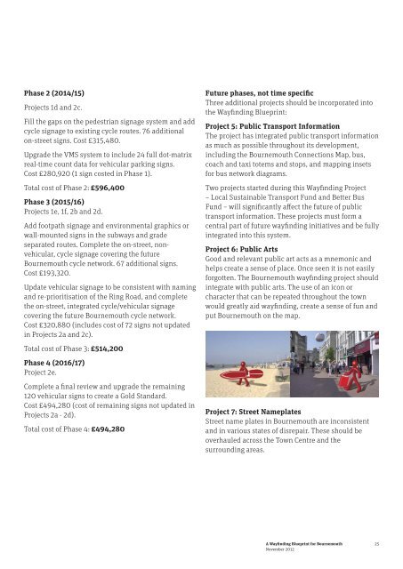
Project 6: Public Arts<br />
Good and relevant public art acts as a mnemonic and<br />
helps create a sense of place. Once seen it is not easily<br />
forgotten. The <strong>Bournemouth</strong> wayfinding project should<br />
integrate with public arts. The use of an icon or<br />
character that can be repeated throughout the town<br />
would greatly aid wayfinding, create a sense of fun and<br />
put <strong>Bournemouth</strong> on the map.<br />
Project 7: Street Nameplates<br />
Street name plates in <strong>Bournemouth</strong> are inconsistent<br />
and in various states of disrepair. These should be<br />
overhauled across the Town Centre and the<br />
surrounding areas.<br />
A <strong>Wayfinding</strong> <strong>Blueprint</strong> for <strong>Bournemouth</strong><br />
November 2012<br />
25