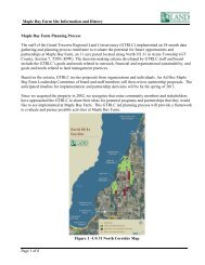
maple bay park & natural area - Grand Traverse Regional Land ...
maple bay park & natural area - Grand Traverse Regional Land ...
maple bay park & natural area - Grand Traverse Regional Land ...

You also want an ePaper? Increase the reach of your titles
YUMPU automatically turns print PDFs into web optimized ePapers that Google loves.
Maple Bay Park<br />
6<br />
<strong>Grand</strong> <strong>Traverse</strong> County, Michigan<br />
Existing<br />
Conditions<br />
<strong>Grand</strong> <strong>Traverse</strong> <strong>Regional</strong><br />
<strong>Land</strong> Conservancy<br />
1<br />
<strong>Grand</strong> <strong>Traverse</strong> <strong>Regional</strong><br />
<strong>Land</strong> Conservancy<br />
US 31<br />
7<br />
Private<br />
property<br />
State of<br />
Michigan<br />
<strong>Grand</strong> <strong>Traverse</strong><br />
<strong>Regional</strong> <strong>Land</strong><br />
Conservancy<br />
2<br />
3<br />
views to Lake<br />
Michigan blocked<br />
by trees<br />
rock jetties<br />
- sandy/stony beach<br />
- (low water 2007)<br />
- foot access only<br />
at present<br />
3<br />
1 2<br />
Forested Foredune<br />
Area<br />
- low, wet<br />
- lowland forest<br />
- beech, hemlock<br />
<strong>maple</strong>, birch<br />
C r o p R o t a t i o n<br />
steep slope acts as barrier<br />
to pedestrian/vehicular movement<br />
hardwood grove<br />
limited underbrush<br />
approximate hunting limit<br />
iconic barn<br />
reasonable condition<br />
historic?<br />
C r o p R o t a t i o n<br />
6' CMP cattle underpass<br />
- good condition, but<br />
may be wet in spring<br />
- good pedestrian<br />
connection under US-31<br />
power lines<br />
Old US-31 paving<br />
power lines<br />
power lines<br />
Bates<br />
8<br />
contiguous<br />
lowland/drainage <strong>area</strong><br />
7<br />
P e t o b e g o S w a m p<br />
8<br />
9<br />
4<br />
MDOT<br />
spoil material<br />
(high point)<br />
community<br />
septic field<br />
Orchard Shores<br />
Common Area<br />
<strong>Grand</strong> <strong>Traverse</strong><br />
<strong>Regional</strong> <strong>Land</strong><br />
Conservancy<br />
4<br />
only vehicular access<br />
into west <strong>park</strong>land<br />
allowed by MDOT<br />
6<br />
shady, grove <strong>area</strong><br />
potential for picnics<br />
newer pole barn<br />
good condition<br />
iconic farmhouse<br />
interior in poor condition<br />
low, drainage <strong>area</strong><br />
- great habitat<br />
- cedar buffer<br />
9<br />
Park Boundary<br />
Powerlines<br />
5<br />
Plum<br />
C r o p R o t a t i o n<br />
Yuba International Airport<br />
(private)<br />
grass runway<br />
High Points<br />
USGS Contours<br />
(Feet above mean sea level)<br />
584 - 600<br />
US 31<br />
great overview<br />
5<br />
600 - 620<br />
620 - 640<br />
640 - 670<br />
Wetland Reserve<br />
1 inch equals 650 feet<br />
0 300 600 1,200<br />
Feet