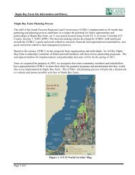
maple bay park & natural area - Grand Traverse Regional Land ...
maple bay park & natural area - Grand Traverse Regional Land ...
maple bay park & natural area - Grand Traverse Regional Land ...

Create successful ePaper yourself
Turn your PDF publications into a flip-book with our unique Google optimized e-Paper software.
MAPLE BAY PARK & NATURAL AREA<br />
generally dry. Paths would tie in to the pedestrian trail under US-31.<br />
The livestock underpass below under US-31 is also located in this <strong>area</strong>,<br />
and could be used as a pedestrian crossing during times of the year<br />
when it is dry.<br />
Upper Hardwood Grove. Currently this <strong>area</strong> is enrolled in the WRP<br />
and development is limited. The current limited underbrush would be<br />
maintained to keep this <strong>area</strong> in its current condition. “Rustic” picnic<br />
<strong>area</strong>s would be permitted in this <strong>area</strong>. A paved trail connection from<br />
the trailhead <strong>park</strong>ing to the pedestrian underpass under US-31 would<br />
follow the top of the bluff through the grove.<br />
EAST SIDE<br />
Hunting on the east<br />
side of US-31 would be<br />
permitted but limited to<br />
shotgun and archery<br />
only.<br />
Croplands (East of Bates Road). Moderate intensity uses on these <strong>area</strong>s<br />
consist of trail access to Petobego Marsh, a casual or occasional hunting<br />
dog training <strong>area</strong> with a <strong>park</strong>ing lot located off of Bates Road; trails<br />
leading from the <strong>park</strong>ing <strong>area</strong> to Petobego Marsh, hunting, and limited<br />
cropland that will support wildlife. Hunting would be permitted west of<br />
Bates Road<br />
Croplands (West of Bates Road). In croplands east of US-31 west of<br />
Bates, moderate intensity uses would consist of maintaining the current<br />
agricultural activities. There is also potential for a small <strong>area</strong> west of<br />
Bates on a high knoll that would contain a picnic <strong>area</strong> and trailhead<br />
accessed from Bates. Hunting on the east side of US-31 would be<br />
permitted but limited to shotgun and archery only.<br />
Farm Buildings. Moderate intensity use for the farm buildings east of<br />
US-31 would consist of stabilizing and preserving the barn, which can be<br />
used as a trailhead facility. The farmhouse would be stabilized based on<br />
a professional evaluation of the structure and cost estimate. It would be<br />
retained for future renovation and potential use as a property care<br />
taker’s residence. Restrooms would be installed in this <strong>area</strong> or as part of<br />
the barn structure. The grounds would include a small gravel <strong>park</strong>ing<br />
<strong>area</strong> and access drive off US-31 to serve as the trailhead.<br />
Wetlands. Because of the WRP restrictions, a feasible moderate<br />
intensity use would consist of mowed trails though the <strong>area</strong>s of the<br />
wetlands that are generally dry. An improved trail is proposed across<br />
the wetland dike connecting Bates Road and the rustic picnic <strong>area</strong> to the<br />
south.<br />
GRAND TRAVERSE COUNTY 20 MAPLE BAY PARK AND NATURAL AREA<br />
MASTER PLAN