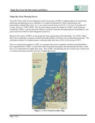
maple bay park & natural area - Grand Traverse Regional Land ...
maple bay park & natural area - Grand Traverse Regional Land ...
maple bay park & natural area - Grand Traverse Regional Land ...

You also want an ePaper? Increase the reach of your titles
YUMPU automatically turns print PDFs into web optimized ePapers that Google loves.
MAPLE BAY PARK & NATURAL AREA<br />
Upper Wetlands. Much of this <strong>area</strong> is enrolled in the WRP. Therefore,<br />
low intensity use of the wetlands consists of leaving the site in its current<br />
condition. Hunting would be permitted north of the current hunting<br />
boundary.<br />
EAST SIDE<br />
Upper Hardwood Grove. This <strong>area</strong> is currently characterized by old<br />
hardwoods with limited underbrush. A low intensity use for this <strong>area</strong><br />
would consist of leaving the site as-is and letting the underbrush grow<br />
back in, which would be compatible with its WRP designation.<br />
Hunting would continue to be permitted in this location.<br />
East Croplands (East of Bates Road). Low intensity uses for the<br />
croplands east of Bates Road consist of leaving the site in its current<br />
condition and maintaining agricultural activities. Hunting would be<br />
permitted in this <strong>area</strong>. Hunting would be permitted north of the<br />
current hunting boundary.<br />
East Croplands (West of Bates Road). The lowest<br />
intensity use for the west croplands would consist of<br />
ceasing agricultural production and letting the land revert<br />
back to its most <strong>natural</strong> state of a northern Michigan<br />
prairie or field grasses.<br />
Plan recommendations present several<br />
options for uses in the agricultural <strong>area</strong>s<br />
East Farm Buildings. The east side of US-31 contains a<br />
farm house and old barn that have deteriorated over time.<br />
The low intensity use of these structures would consist of<br />
razing them and letting the native vegetation reclaim the<br />
<strong>area</strong>. The newer pole barn would be retained as a service<br />
building for the <strong>park</strong>.<br />
East Farmstead Area. The mowed <strong>area</strong> near the<br />
buildings would be maintained as an entry point from<br />
US-31 to the east half of the <strong>park</strong>, a trailhead, and a<br />
picnic <strong>area</strong>.<br />
East Wetlands. Much of this <strong>area</strong> is enrolled in the<br />
WRP. Therefore, low intensity use of the wetlands<br />
consists of leaving the site in its current condition.<br />
Hunting would be permitted in these <strong>area</strong>s.<br />
Wetland <strong>area</strong>s are home to a variety of<br />
wildlife<br />
GRAND TRAVERSE COUNTY 16 MAPLE BAY PARK AND NATURAL AREA<br />
MASTER PLAN