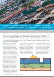
Nicoll Highway Collapse: Evaluation of Geotechnical ... - Plaxis
Nicoll Highway Collapse: Evaluation of Geotechnical ... - Plaxis
Nicoll Highway Collapse: Evaluation of Geotechnical ... - Plaxis

You also want an ePaper? Increase the reach of your titles
YUMPU automatically turns print PDFs into web optimized ePapers that Google loves.
ent excavation depth and s u the undrained shear strength <strong>of</strong> the clay (below the excavated grade). For<br />
cases where Δp > 0 (i.e., γH > 4s u – which commonly occurs for deep excavations in s<strong>of</strong>t-medium<br />
clays), the wall must transfer the net earth pressure forces to the overlying bracing system and/or span<br />
between the bracing system and an underlying bearing layer (such as the Old Alluvium, Fig. 1). For<br />
the cut-and-cover sections <strong>of</strong> the Circle Line contract C824, the JGP rafts have been included to increase<br />
the shear strength <strong>of</strong> the materials below the excavated grade and hence, increase the available<br />
passive resistance. The actual design <strong>of</strong> the earth support system was based on non-linear finite element<br />
methods which simulate the mobilization and redistribution <strong>of</strong> the earth pressures, flexure <strong>of</strong> the<br />
wall and strutting system at each stage <strong>of</strong> the excavation.<br />
Figure 1. Cross-section <strong>of</strong> excavation support system, Type M3<br />
(soil pr<strong>of</strong>ile is based on borehole ABH-32)<br />
2 SITE CHARACTERIZATION AND SOIL PROPERTIES<br />
Figure 2 shows the locations <strong>of</strong> the pre- and post-tender boreholes (M and ABH series, respectively),<br />
that were used to establish the site stratigraphy for the cut-and-cover tunnel sections adjacent to the<br />
TSA shaft. The site is located on the west bank <strong>of</strong> the Kallang River south <strong>of</strong> <strong>Nicoll</strong> <strong>Highway</strong> in an<br />
area <strong>of</strong> reclaimed land. The Merdeka bridge, Figure 3, was constructed in 1956 (Hollis-Bee, 1956)<br />
following reclamation <strong>of</strong> the area between Beach Road and <strong>Nicoll</strong> <strong>Highway</strong> in the 1930’s and 1940’s.<br />
Further reclamation south <strong>of</strong> <strong>Nicoll</strong> <strong>Highway</strong> was not completed until 1976. The aerial photo from<br />
1969 confirms that the TSA shaft and adjacent sections <strong>of</strong> the cut-and-cover tunnels (Type M3) are<br />
located beneath the land that was reclaimed during the 1970’s. The characteristic soil pr<strong>of</strong>ile includes<br />
4.5–5.0m <strong>of</strong> fill underlain by 30–35m <strong>of</strong> Kallang formation soil deposits and the Old Alluvium. The<br />
engineering geology <strong>of</strong> these main soil units has been extensively documented by Pitts (1983, 1984).<br />
The underlying Old Alluvium is generally assumed to date from the early Pleistocene and was formed<br />
principally as terrace deposits from a large braided river system that covered much <strong>of</strong> South East Asia