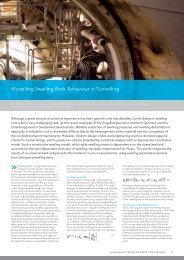
Nicoll Highway Collapse: Evaluation of Geotechnical ... - Plaxis
Nicoll Highway Collapse: Evaluation of Geotechnical ... - Plaxis
Nicoll Highway Collapse: Evaluation of Geotechnical ... - Plaxis

You also want an ePaper? Increase the reach of your titles
YUMPU automatically turns print PDFs into web optimized ePapers that Google loves.
very stiff to hard, silty clay. The SPT blowcount increases markedly with depth in the Old Alluvium,<br />
ranging from N = 10-20blows/300mm (i.e., blows/foot, bpf) near the upper surface to N > 100bpf<br />
typically over a depth <strong>of</strong> 6m – 10m. In order to simplify the interpretation <strong>of</strong> the local geology it is<br />
convenient to define the top <strong>of</strong> the Old Alluvium based on measured SPT blowcount, N > 30bpf corresponding<br />
to material which can provide adequate toe resistance for the diaphragm wall. Figures 4a<br />
and b show elevation contours <strong>of</strong> the base <strong>of</strong> the Lower Marine Clay (or Estuarine) unit and top <strong>of</strong> the<br />
Old Alluvium at the C824 site (the ground surface is level at 102.9m RL across the site). There is a<br />
well defined channel in the Old Alluvium (Fig. 4b) which extends in a North-South direction across<br />
the line <strong>of</strong> the cut-and-cover tunnels and reaches a maximum depth <strong>of</strong> 42m close to the TSA shaft. At<br />
this same location the Lower Marine Clay extends to a depth <strong>of</strong> approximately 40m. The Old Alluvium<br />
rises progressively moving westwards along the tunnel alignment (types M3 and M2), while the<br />
Marine Clay remains deeper along the southern side <strong>of</strong> the tunnels. More detailed observations <strong>of</strong> the<br />
borings indicate transitional fluvial sand units (F1) between the Old Alluvium and Marine Clay on the<br />
North side <strong>of</strong> the tunnels, and fluvial clay units (F2) on the South side.<br />
a) Contours <strong>of</strong> base <strong>of</strong> Lower Marine Clay (m RL)<br />
b) Contours showing top <strong>of</strong> Old Alluvium (N > 30bpf)<br />
Figure 4. Elevation contours derived from pre- and post-tender borehole data<br />
The elevation contours affect the construction <strong>of</strong> the lateral earth support in two key respects: i) The<br />
installation depth <strong>of</strong> diaphragm wall panels should ensure adequate embedment in the Old Alluvium to<br />
achieve toe fixity. The original intent <strong>of</strong> the design was to achieve 3m embedment within the Old Alluvium<br />
(Fig. 1). However, construction records show that the individual panels <strong>of</strong> the diaphragm wall<br />
were actually installed to specified design elevations rather than embedment requirements, Figure 5.<br />
Indeed, several panels have embedment depths less than 1m within the Old Alluvium (with N ><br />
30bpf). ii) Continuity <strong>of</strong> the JGP raft depends on achieving a specified diameter for each the individ-