Phosphorus and the Kawartha Lakes - Lakefield Herald
Phosphorus and the Kawartha Lakes - Lakefield Herald
Phosphorus and the Kawartha Lakes - Lakefield Herald

Create successful ePaper yourself
Turn your PDF publications into a flip-book with our unique Google optimized e-Paper software.
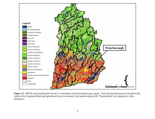
IJ 2 IJ 18 IJ 5<br />
IJ 1<br />
IJ 3<br />
Legend<br />
IJ 4 IJ 20<br />
Water<br />
FreshwaterMarsh<br />
Deciduous Swamp<br />
ConiferSwamp<br />
open fen<br />
open bog<br />
treed bog<br />
dense deciduous<br />
dense coniferous<br />
coniferous plantation<br />
mixed deciduous<br />
mixed coniferous<br />
sparse coniferous<br />
sparse deciduous<br />
recent cutover<br />
bedrock/s<strong>and</strong>/gravel<br />
settlement<br />
pasture <strong>and</strong> ab<strong>and</strong>oned fields<br />
cropl<strong>and</strong><br />
alvar<br />
unclassified<br />
IJ 6 IJ 14<br />
IJ 12<br />
17 IJ 21<br />
IJ 29<br />
IJ 7 IJ 9<br />
IJ 11<br />
IJ 10<br />
IJ 23<br />
IJ 16 IJ 15<br />
IJ 24 IJ 25<br />
IJ 19 IJ<br />
IJ 22<br />
IJ<br />
IJ 27<br />
IJ 30<br />
IJ 31 IJ 8<br />
Peterborough<br />
4.5<br />
{Kilometers<br />
IJ 13 IJ 26 0 9 18 27 36<br />
Figure 2.1 NRVIS l<strong>and</strong> classification for <strong>the</strong> 31 watersheds of <strong>the</strong> <strong>Kawartha</strong> <strong>Lakes</strong> region. Note that forested areas are located in <strong>the</strong><br />
north on <strong>the</strong> Canadian Shield <strong>and</strong> agricultural areas are located to <strong>the</strong> south on glacial till. Watershed Id’s are depicted in white<br />
pentagons.<br />
6