Phosphorus and the Kawartha Lakes - Lakefield Herald
Phosphorus and the Kawartha Lakes - Lakefield Herald
Phosphorus and the Kawartha Lakes - Lakefield Herald

You also want an ePaper? Increase the reach of your titles
YUMPU automatically turns print PDFs into web optimized ePapers that Google loves.
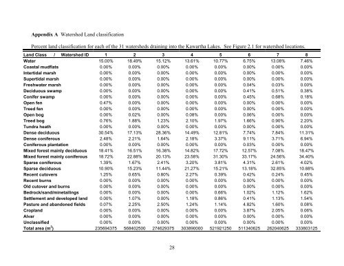
Appendix A Watershed L<strong>and</strong> classification<br />
Percent l<strong>and</strong> classification for each of <strong>the</strong> 31 watersheds draining into <strong>the</strong> <strong>Kawartha</strong> <strong>Lakes</strong>. See Figure 2.1 for watershed locations.<br />
L<strong>and</strong> Class / Watershed ID 1 2 3 4 5 6 7 8<br />
Water 15.00% 18.49% 15.12% 13.61% 10.77% 6.75% 13.08% 7.46%<br />
Coastal mudflats 0.00% 0.00% 0.00% 0.00% 0.00% 0.00% 0.00% 0.00%<br />
Intertidal marsh 0.00% 0.00% 0.00% 0.00% 0.00% 0.00% 0.00% 0.00%<br />
Supertidal marsh 0.00% 0.00% 0.00% 0.00% 0.00% 0.00% 0.00% 0.00%<br />
Freshwater marsh 0.00% 0.00% 0.00% 0.00% 0.00% 0.04% 0.03% 0.00%<br />
Deciduous swamp 0.00% 0.00% 0.00% 0.00% 0.00% 0.41% 0.51% 0.38%<br />
Conifer swamp 0.00% 0.00% 0.00% 0.00% 0.00% 0.45% 0.68% 0.18%<br />
Open fen 0.47% 0.00% 0.00% 0.00% 0.00% 0.00% 0.00% 0.00%<br />
Treed fen 0.00% 0.00% 0.00% 0.00% 0.00% 0.00% 0.00% 0.00%<br />
Open bog 0.00% 0.02% 0.00% 0.08% 0.00% 0.06% 0.00% 0.00%<br />
Treed bog 0.76% 1.88% 1.23% 2.10% 1.97% 1.66% 0.90% 2.20%<br />
Tundra heath 0.00% 0.00% 0.00% 0.00% 0.00% 0.00% 0.00% 0.00%<br />
Dense deciduous 30.54% 17.13% 28.36% 14.49% 12.81% 7.74% 7.84% 11.31%<br />
Dense coniferous 2.48% 2.21% 1.64% 2.18% 3.37% 9.11% 3.71% 6.94%<br />
Coniferous plantation 0.00% 0.00% 0.00% 0.00% 0.00% 0.03% 0.00% 0.00%<br />
Mixed forest mainly deciduous 18.41% 16.51% 16.38% 14.82% 17.72% 12.57% 7.08% 18.47%<br />
Mixed forest mainly coniferous 18.72% 22.88% 20.13% 23.58% 31.30% 33.17% 24.56% 34.40%<br />
Sparse coniferous 1.39% 1.67% 2.41% 3.20% 3.81% 4.31% 2.61% 4.02%<br />
Sparse deciduous 10.90% 15.23% 11.44% 21.27% 15.21% 13.18% 32.85% 10.88%<br />
Recent cutovers 1.25% 0.65% 0.80% 2.27% 0.39% 0.42% 0.24% 0.45%<br />
Recent burns 0.00% 0.00% 0.00% 0.00% 0.00% 0.00% 0.00% 0.00%<br />
Old cutover <strong>and</strong> burns 0.00% 0.00% 0.00% 0.00% 0.00% 0.00% 0.00% 0.00%<br />
Bedrock/s<strong>and</strong>/minetailings 0.00% 0.00% 0.00% 0.00% 0.66% 1.02% 1.12% 1.62%<br />
Settlement <strong>and</strong> developed l<strong>and</strong> 0.00% 1.07% 0.00% 1.18% 0.86% 0.41% 1.13% 1.54%<br />
Pasture <strong>and</strong> ab<strong>and</strong>oned fields 0.07% 2.25% 2.50% 1.24% 1.14% 4.82% 1.60% 0.08%<br />
Cropl<strong>and</strong> 0.00% 0.00% 0.00% 0.00% 0.00% 3.87% 2.05% 0.06%<br />
Alvar 0.00% 0.00% 0.00% 0.00% 0.00% 0.00% 0.00% 0.00%<br />
Unclassified 0.00% 0.00% 0.00% 0.00% 0.00% 0.00% 0.00% 0.00%<br />
Total area (m 2 ) 235694375 568402500 274629375 303890000 521921250 511340625 262040625 333803125<br />
28