Phosphorus and the Kawartha Lakes - Lakefield Herald
Phosphorus and the Kawartha Lakes - Lakefield Herald
Phosphorus and the Kawartha Lakes - Lakefield Herald

Create successful ePaper yourself
Turn your PDF publications into a flip-book with our unique Google optimized e-Paper software.
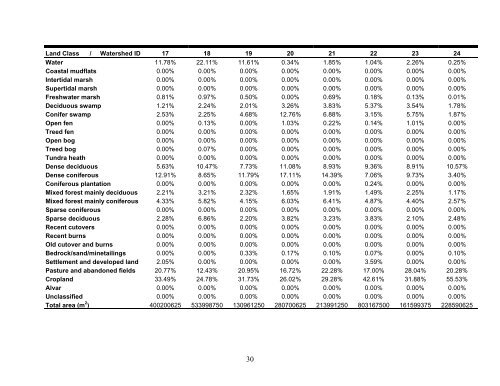
L<strong>and</strong> Class / Watershed ID 17 18 19 20 21 22 23 24<br />
Water 11.78% 22.11% 11.61% 0.34% 1.85% 1.04% 2.26% 0.25%<br />
Coastal mudflats 0.00% 0.00% 0.00% 0.00% 0.00% 0.00% 0.00% 0.00%<br />
Intertidal marsh 0.00% 0.00% 0.00% 0.00% 0.00% 0.00% 0.00% 0.00%<br />
Supertidal marsh 0.00% 0.00% 0.00% 0.00% 0.00% 0.00% 0.00% 0.00%<br />
Freshwater marsh 0.81% 0.97% 0.50% 0.00% 0.69% 0.18% 0.13% 0.01%<br />
Deciduous swamp 1.21% 2.24% 2.01% 3.26% 3.83% 5.37% 3.54% 1.78%<br />
Conifer swamp 2.53% 2.25% 4.68% 12.76% 6.88% 3.15% 5.75% 1.87%<br />
Open fen 0.00% 0.13% 0.00% 1.03% 0.22% 0.14% 1.01% 0.00%<br />
Treed fen 0.00% 0.00% 0.00% 0.00% 0.00% 0.00% 0.00% 0.00%<br />
Open bog 0.00% 0.00% 0.00% 0.00% 0.00% 0.00% 0.00% 0.00%<br />
Treed bog 0.00% 0.07% 0.00% 0.00% 0.00% 0.00% 0.00% 0.00%<br />
Tundra heath 0.00% 0.00% 0.00% 0.00% 0.00% 0.00% 0.00% 0.00%<br />
Dense deciduous 5.63% 10.47% 7.73% 11.08% 8.93% 9.36% 8.91% 10.57%<br />
Dense coniferous 12.91% 8.65% 11.79% 17.11% 14.39% 7.06% 9.73% 3.40%<br />
Coniferous plantation 0.00% 0.00% 0.00% 0.00% 0.00% 0.24% 0.00% 0.00%<br />
Mixed forest mainly deciduous 2.21% 3.21% 2.32% 1.65% 1.91% 1.49% 2.25% 1.17%<br />
Mixed forest mainly coniferous 4.33% 5.82% 4.15% 6.03% 6.41% 4.87% 4.40% 2.57%<br />
Sparse coniferous 0.00% 0.00% 0.00% 0.00% 0.00% 0.00% 0.00% 0.00%<br />
Sparse deciduous 2.28% 6.86% 2.20% 3.82% 3.23% 3.83% 2.10% 2.48%<br />
Recent cutovers 0.00% 0.00% 0.00% 0.00% 0.00% 0.00% 0.00% 0.00%<br />
Recent burns 0.00% 0.00% 0.00% 0.00% 0.00% 0.00% 0.00% 0.00%<br />
Old cutover <strong>and</strong> burns 0.00% 0.00% 0.00% 0.00% 0.00% 0.00% 0.00% 0.00%<br />
Bedrock/s<strong>and</strong>/minetailings 0.00% 0.00% 0.33% 0.17% 0.10% 0.07% 0.00% 0.10%<br />
Settlement <strong>and</strong> developed l<strong>and</strong> 2.05% 0.00% 0.00% 0.00% 0.00% 3.59% 0.00% 0.00%<br />
Pasture <strong>and</strong> ab<strong>and</strong>oned fields 20.77% 12.43% 20.95% 16.72% 22.28% 17.00% 28.04% 20.28%<br />
Cropl<strong>and</strong> 33.49% 24.78% 31.73% 26.02% 29.28% 42.61% 31.88% 55.53%<br />
Alvar 0.00% 0.00% 0.00% 0.00% 0.00% 0.00% 0.00% 0.00%<br />
Unclassified 0.00% 0.00% 0.00% 0.00% 0.00% 0.00% 0.00% 0.00%<br />
Total area (m 2 ) 400200625 533998750 130961250 280700625 213991250 803167500 161599375 228590625<br />
30