Chapter 7 - The Built & Natural Heritage - Waterford County Council
Chapter 7 - The Built & Natural Heritage - Waterford County Council
Chapter 7 - The Built & Natural Heritage - Waterford County Council

Create successful ePaper yourself
Turn your PDF publications into a flip-book with our unique Google optimized e-Paper software.
45<br />
<strong>Waterford</strong> City Environs Local Area Plan 2008-2014<br />
<strong>Chapter</strong> 5 Economy & Employment<br />
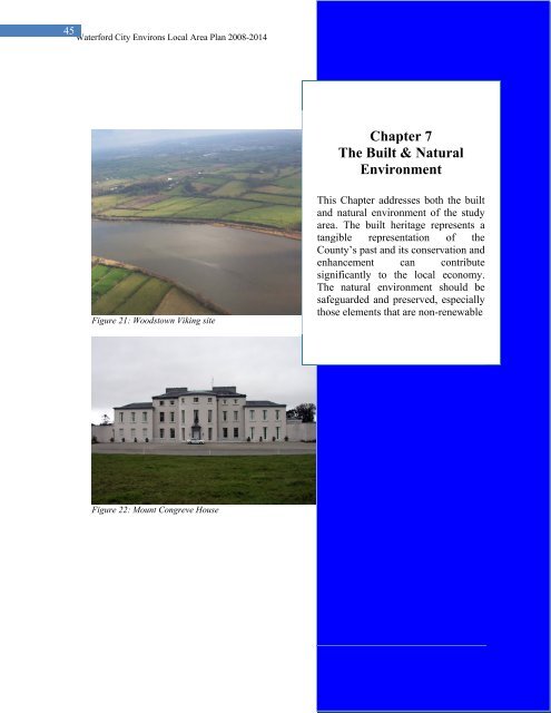
<strong>Chapter</strong> 7<br />
<strong>The</strong> <strong>Built</strong> & <strong>Natural</strong><br />
Environment<br />
Figure 21: Woodstown Viking site<br />
This <strong>Chapter</strong> addresses both the built<br />
and natural environment of the study<br />
area. <strong>The</strong> built heritage represents a<br />
tangible representation of the<br />
<strong>County</strong>’s past and its conservation and<br />
enhancement can contribute<br />
significantly to the local economy.<br />
<strong>The</strong> natural environment should be<br />
safeguarded and preserved, especially<br />
those elements that are non-renewable<br />
Figure 22: Mount Congreve House
46 <strong>Waterford</strong> City Environs Local Area Plan 2008-2014<br />
<strong>Chapter</strong> 7 <strong>The</strong> <strong>Built</strong> & <strong>Natural</strong> Environment<br />
7.1 Introduction<br />
<strong>The</strong> Plan Area includes landscapes of very high quality, notably the Mount Congreve<br />
Estate, Whitfield Estate and the River Suir environs. <strong>The</strong>se amenities are of essential<br />
value being located so close to the built up area of <strong>Waterford</strong> City.<br />
7.2 Landscape types<br />
7.2.1 Agricultural Hinterland<br />
Most of this area comprises agriculture pasture farmland which has been subject to<br />
pressure for one-off housing. Farm dwellings, holdings and agricultural buildings form<br />
an integral part of this area. Included in this area are historic buildings set in estate<br />
demesne and some non conforming existing uses.<br />
7.2.2 Scenic Landscape Evaluation<br />
A Scenic Landscape Evaluation, which identifies areas of sensitivity, visual<br />
vulnerability and classifies the capacity of an area to absorb development, is contained<br />
in the <strong>County</strong> Development Plan. Scenic routes within the plan area include the R675<br />
and the R684 at Coolgower and Ballygunner. <strong>The</strong> policy with regard to scenic routes<br />
as set out in <strong>County</strong> Development Plan which is to ensure that there will be no<br />
obstruction or degradation of the views towards visually vulnerable features or<br />
significant alterations to the appearance or character of sensitive areas shall be<br />
implemented in the plan area. Visually vulnerable areas within the plan area are<br />
located at Ballycashin, Ballycanvan, and the River Suir while areas described as<br />
sensitive occur at Mount Congreve, Ballyhoo, Duagh, Ballinamona, Moanmintra, and<br />
Kilcaragh 5 .<br />
7.2.3 Protected Structures<br />
A full list of protected structure in the <strong>County</strong> is included in the appendix to the<br />
<strong>Waterford</strong> <strong>County</strong> Development Plan 2005-2011 and can be viewed on the <strong>Council</strong>’s<br />
website www.waterfordcoco.ie. Such structures within the study area include the<br />
following:<br />
RPS No. Protected Structure Details<br />
15 Thatched Cottage, Matthews Cross Vernacular architecture<br />
328 Foxmount Country House<br />
291 Carriganore Country House<br />
316 Fairbrook Factory Mill Building<br />
35 Mount Congreve Country house rated as nationally important in NIAH<br />
128 <strong>The</strong> Sweep Pub, Adamstown Thatched Cottage<br />
318 Cosy Thatch Pub, Old Kilmeaden Thatched building<br />
129 Whitfield Court Rated as Nationally important by the NIAH<br />
34 Butlerstown Castle Late Medieval Tower House with C18th dwelling<br />
5 Scenic Landscape Evaluation, Appendix 4, <strong>Waterford</strong> <strong>County</strong> Development Plan 2005-2011.
47 <strong>Waterford</strong> City Environs Local Area Plan 2008-2014<br />
<strong>Chapter</strong> 7 <strong>The</strong> <strong>Built</strong> & <strong>Natural</strong> Environment<br />
house<br />
313 Ballygunnercastle Castle<br />
279 Ballinamona House Country House<br />
276 Ballycanvan Little Bridge<br />
278 Woodland House Country House<br />
Table 9: List of Protected Structures within the Study Area<br />
7.2.4 Demesne Landscapes<br />
<strong>The</strong> study area includes two demesne landscapes, Whitfield Court and Mount<br />
Congreve. <strong>The</strong>se lands are of high amenity value comprising built and natural heritage<br />
qualities. Both buildings are listed as Protected Structures in the <strong>County</strong> Development<br />
Plan and are rated by the National Inventory of Architectural <strong>Heritage</strong> (NIAH) as<br />
being of national importance. Mount Congreve Estate is situated at a sheltered bend<br />
along the River Suir 2km north east of Kilmeaden Village and a 10 minute drive from<br />
<strong>Waterford</strong> City. <strong>The</strong> Estate comprises over 600 acres, 100 of which form the gardens<br />
of international importance. A wholesale nursery business is also located within the<br />
estate. <strong>The</strong> gardens are now held in Trust and will be transferred to the Office of Public<br />
Works for the enjoyment by the State in the future. <strong>The</strong> gardens are currently open to<br />
the public on a limited basis and attract visitor numbers around 3,000 per annum.<br />
Whitfield Court is a 200 acre estate situated within an impressive landscape at<br />
Dooneen and Powersknock that boasts a wide selection of mature deciduous trees in an<br />
attractive landscape valley. Permission has been granted on the site for an 18 hole golf<br />
course, 20 two-storey chalets and a clubhouse/hotel conversion of Whitfield Court<br />
House, a separate 86 bedroom 4/5 star hotel, leisure centre and 27 lakeside hotel<br />
lodges, construction of a stocked lake, a new sewage treatment plant and reinstatement<br />
of an existing canal and ditches.<br />
Any development within these estates shall have regard to the landscape character of<br />
the demesne and shall not detract from the quality of the environment. Development<br />
shall be of a scale and density appropriate the setting having regard to the topography<br />
of the land, natural screening and visual vulnerability of the area.<br />
Local Area Plan Objective<br />
BHER1<br />
To protect all built heritage within the Plan area through<br />
appropriate designation and inclusion on the Record of<br />
Protected Structures<br />
BHER2<br />
To seek the retention, conservation and appropriate repair of<br />
buildings and traditional features such as traditional pub/shop<br />
fronts within the study area and to assess their appropriateness<br />
for inclusion in the Record of Protected Structures.
48 <strong>Waterford</strong> City Environs Local Area Plan 2008-2014<br />
<strong>Chapter</strong> 7 <strong>The</strong> <strong>Built</strong> & <strong>Natural</strong> Environment<br />
BHER 3<br />
To protect the character and quality of demesne landscapes.<br />
<strong>The</strong> setting of a proposed development within a demesne<br />
landscape is a significant consideration and will be addressed<br />
in any planning application. No development shall be<br />
permitted which would result in adverse visual impact or loss<br />
of landscape character.<br />
BHER 4<br />
To protect semi mature and mature trees, groups of trees and<br />
tree shelter belts within the demesnes of Whitfield Court and<br />
Mount Congreve.<br />
7.2.5 Valleys and River Environs<br />
Other distinctive landscapes within the study area include watercourses which flow<br />
into the River Suir- the Dawn River, Whelan Bridge River, Ballymoat Stream and<br />
Ballycanvan Stream. <strong>The</strong> landscapes in these areas are of value because of their low<br />
lying nature and the enclosure created by valley sides and adjacent woodland. <strong>The</strong><br />
River Suir and sections of the inflowing Whelanbridge River and Ballycanvan Stream<br />
are also designated Special Areas of Conservation on account of their important habitat<br />
value.<br />
7.2.6 River Suir Special Area of Conservation<br />
Special Areas of Conservation (SACs) are areas of prime wildlife conservation in the<br />
country, considered to be important on a European as well as Irish level. <strong>The</strong> Lower<br />
River Suir is designated SAC for its importance for Annex 1 habitats including<br />
Alluvial Woodland and floating river vegetation. <strong>The</strong> site is also designated for its<br />
importance for Annex II species such as Lamprey, Otter, Salmon, Pearl Mussel,<br />
Crayfish and Twaite Shad. Within the study area the Lower River Suir SAC includes<br />
parts of Whelanbridge River near Mount Congreve and the Ballycanvan Stream.<br />
In order to protect internationally important habitats, the Habitats Directive places<br />
restrictions on the management of land that has been designated as an SAC. Works that<br />
are not defined as “Development” under the Planning and Development Acts (2000-<br />
2006) may be considered as “Notifiable Actions” i.e. actions that may damage the<br />
wildlife interest of the site. <strong>The</strong>se actions can only be carried out with consent from the<br />
Department of the Environment, <strong>Heritage</strong> and Local Government. Examples include<br />
the alteration of a watercourse, reclamation, burning or infilling.<br />
In addition to the designated sites biodiversity also includes species, habitats and<br />
ecosystems, which are not statutorily designated but may be of regional or local<br />
importance. Details of <strong>Waterford</strong>’s natural heritage in terms of biodiversity, flora and<br />
fauna are set out in Section 4.2.6 of the Environmental Report.
49 <strong>Waterford</strong> City Environs Local Area Plan 2008-2014<br />
<strong>Chapter</strong> 7 <strong>The</strong> <strong>Built</strong> & <strong>Natural</strong> Environment<br />
7.3 Water Resources<br />
<strong>The</strong> Study area contains several river catchments namely Dawn River, Whelan Bridge<br />
River, John’s River, Ballycanvan Stream/Halfway House Stream, Ballymoat Stream<br />
and Keilogue River. All of these are tributaries of the River Suir which is designated a<br />
Special Area of Conservation.<br />
<strong>The</strong> principal legislation governing water quality in Ireland is the European<br />
Communities (Water Policy) Regulations 2003 (S.I. 722 of 2003) which transposed<br />
Directive 2000/60/EC (the Water Framework Directive-WFD) into Irish Law. <strong>The</strong><br />
WFD sets out that Member States shall implement the necessary measures to prevent<br />
deterioration of the status of all bodies of surface water, and shall protect, enhance and<br />
restore all bodies of surface water with the aim of achieving good status by 2015.<br />
Good status as defined by the WFD equates approximately to Q4 in the national<br />
scheme of biological classification. <strong>Waterford</strong> is divided between two regions for the<br />
purposes of implementation of the Water Framework Directive. <strong>The</strong> plan area is within<br />
the South Eastern River Basin District Area (SERBD).<br />
7.3.1 Flood Risk and Drainage<br />
<strong>The</strong> effect of climate change is increasing the incidence and severity of flooding and it<br />
is therefore increasingly important to take account of flood risk in landuse planning<br />
and development. Any development that reduces the rate of absorption or increases the<br />
rate of runoff increases the risk of flooding of lands and properties downstream.<br />
A number of flooding related projects have been undertaken by the Office of Public<br />
Works (OPW) including the facilitation of a governmental review into flooding issues<br />
and management and the preparation of national flood risk maps. Guidance on the<br />
Consideration of Flood Risk in Planning and Development Management is currently<br />
being prepared by the OPW. Flood Points and Benefiting lands in the study area are<br />
identified in Map 10 of the Environmental Report accompanying this plan. <strong>The</strong>se<br />
occur along the valley of Whelan’s Bridge River and the Ballymoat Stream through<br />
Mount Congreve Estate, Dooneen, Powersknock and Whitfield Court. <strong>The</strong><br />
Environmental Impact Statement for the N25 <strong>Waterford</strong> bypass states this area is<br />
subject to periodic winter flooding.<br />
<strong>The</strong> OPW has recognized the high levels of existing flood risk around the River Suir<br />
and its tributaries and that there is a potential for significant increases in this risk due to<br />
climate change, ongoing development and other pressures that may arise in the future.<br />
A catchment based flood risk assessment and management study in the Suir catchment<br />
as a means of addressing this problem was undertaken. <strong>The</strong> study was launched in mid<br />
2007 and expected to be completed in 2009.
50 <strong>Waterford</strong> City Environs Local Area Plan 2008-2014<br />
<strong>Chapter</strong> 7 <strong>The</strong> <strong>Built</strong> & <strong>Natural</strong> Environment<br />
Local Area Plan Objective<br />
WAT1<br />
It is an objective of this Plan to conserve and enhance<br />
the diversity of habitats and species.<br />
7.4 Archaeological Protection<br />
<strong>The</strong> Woodstown Viking site is located on the southern bank of the River Suir in<br />
<strong>County</strong> <strong>Waterford</strong>, close to <strong>Waterford</strong> City (See <strong>Natural</strong> <strong>Heritage</strong> Map, Map 3).<br />
Considerable items of archaeological artefacts were discovered, and this site appears to<br />
represent a defended, riverside settlement, with associated industrial activity. <strong>The</strong>re<br />
was abundant evidence for craft-workings in fine metals (e.g. silver), as well as iron<br />
working, stone, glass, bone, antler and amber.<br />
7.4.1 Woodstown ‘Viking Site’<br />
<strong>The</strong> artefacts and the radiocarbon dates taken together confirm the site most likely<br />
dates to the early medieval period c. 6 th century to early 12 th century AD. Indications<br />
are that the Norse possibly used an existing settlement of native Irish origin. <strong>The</strong> site<br />
was discovered during the course of pre-contract archaeological testing undertaken on<br />
the City By Pass scheme<br />
<strong>The</strong> Minister for the Environment, <strong>Heritage</strong> and Local Government issued<br />
archaeological directions for the Woodstown site on the 11 th May 2005. <strong>The</strong> Minister’s<br />
directions provide that the archaeological site is to be preserved and this necessitated a<br />
revised alignment for a section of the route.<br />
<strong>The</strong> Final Report of the Woodstown Working Group to the Minister for the<br />
Environment, <strong>Heritage</strong> and Local Government on the future preservation and<br />
archaeological investigation of the national monument site at Woodstown was<br />
completed in January 2008. the report states that the Woodstown site is of fundamental<br />
importance not simply on a regional or national level but internationally. It is thought<br />
to be one of the most productive dry sites of Early Medieval date ever discovered in<br />
Ireland.<br />
Local Area Plan Objective<br />
ARCH1<br />
It is an objective of this Plan to protect and preserve the<br />
Woodstown Archaeological Excavation Site.
51 <strong>Waterford</strong> City Environs Local Area Plan 2008-2014<br />
<strong>Chapter</strong> 7 <strong>The</strong> <strong>Built</strong> & <strong>Natural</strong> Environment<br />
ARCH2<br />
ARCH3<br />
It is an objective of the plan to support the placement of<br />
the site on the Register of Historic Monuments to afford<br />
it protection under the National Monuments Acts.<br />
Proposed developments that may have implications for<br />
the archaeological heritage may be subject to<br />
archaeological assessment. Such developments include<br />
those that are located at or close to archaeological<br />
monuments or sites.