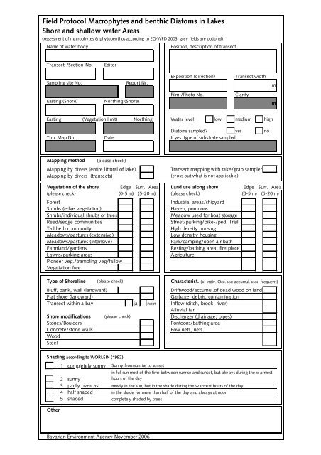
Field Protocol Macrophytes and benthic Diatoms in Lakes Shore ...
Field Protocol Macrophytes and benthic Diatoms in Lakes Shore ...
Field Protocol Macrophytes and benthic Diatoms in Lakes Shore ...

Create successful ePaper yourself
Turn your PDF publications into a flip-book with our unique Google optimized e-Paper software.
<strong>Field</strong> <strong>Protocol</strong> <strong>Macrophytes</strong> <strong>and</strong> <strong>benthic</strong> <strong>Diatoms</strong> <strong>in</strong> <strong>Lakes</strong><br />
<strong>Shore</strong> <strong>and</strong> shallow water Areas<br />
(Assessment of macrophytes & phytobenthos accord<strong>in</strong>g to EG-WFD 2003; grey fields are optional)<br />
Name of water body<br />
Position, description of transect<br />
Transect-/Section-No.<br />
Editor<br />
Sampl<strong>in</strong>g site No.<br />
Report Nr.<br />
Exposition (direction)<br />
Transect width<br />
m<br />
East<strong>in</strong>g (<strong>Shore</strong>)<br />
North<strong>in</strong>g (<strong>Shore</strong>)<br />
Film-/Photo No.<br />
Clarity<br />
m<br />
East<strong>in</strong>g (Vegetation limit) North<strong>in</strong>g Water level low medium high<br />
<strong>Diatoms</strong> sampled? yes no<br />
Top. Map No. Date If yes: type of substrate sampled<br />
Mapp<strong>in</strong>g method (please check)<br />
Mapp<strong>in</strong>g by divers (entire littoral of lake)<br />
Mapp<strong>in</strong>g by divers (transects)<br />
Transect mapp<strong>in</strong>g with rake/grab sampler<br />
(cross out what is not applicable)<br />
Vegetation of the shore Edge Surr. Area L<strong>and</strong> use along shore Edge Surr. Area<br />
(please check) (0-5 m) (5-20 m) (please check) (0-5 m) (5-20 m)<br />
Forest<br />
Shrubs (edge vegetation)<br />
Shrubs/<strong>in</strong>dividual shrubs or trees<br />
Reed/sedge communities<br />
Tall herb community<br />
Meadows/pastures (extensive)<br />
Meadows/pastures (<strong>in</strong>tensive)<br />
Farml<strong>and</strong>/gardens<br />
Lawns/park<strong>in</strong>g areas<br />
Pioneer veg./trampl<strong>in</strong>g veg/fallow<br />
Vegetation free<br />
Industrial areas/shipyard<br />
Haven, pontoons<br />
Meadow used for boat storage<br />
Street/park<strong>in</strong>g/bike-/ped. Trail<br />
High density hous<strong>in</strong>g<br />
Low densitiy hous<strong>in</strong>g<br />
Park/camp<strong>in</strong>g/open air bath<br />
Rest<strong>in</strong>g/bath<strong>in</strong>g area, fire place<br />
Agriculture<br />
Type of <strong>Shore</strong>l<strong>in</strong>e (please check) Characterist. (x: <strong>in</strong>div. Occ. xx: accumul. xxx: frequent)<br />
Bluff, bank, wall (l<strong>and</strong>ward)<br />
Driftwood/accumul.of dead wood on l<strong>and</strong><br />
Flat shore (l<strong>and</strong>ward)<br />
Garbage, debris, contam<strong>in</strong>ation<br />
Transect with<strong>in</strong> a bay ja ne<strong>in</strong> Inflow (ditch, brook, river)<br />
Alluvial fan<br />
<strong>Shore</strong> modifications (please check) Discharger (dra<strong>in</strong>age, pipes)<br />
Stones/Boulders<br />
Pontoons/bath<strong>in</strong>g area<br />
Concrete/stone walls<br />
Bow nets, nets<br />
Wood<br />
Steel<br />
Shad<strong>in</strong>g accord<strong>in</strong>g to WÖRLEIN (1992)<br />
1 completely sunny Sunny from sunrise to sunset<br />
<strong>in</strong> full sun most of the time betw een sunrise <strong>and</strong> sunset, but alw ays dur<strong>in</strong>g the w armest<br />
2 sunny<br />
hours of the day<br />
3 partly overcast mostly <strong>in</strong> the sun, but <strong>in</strong> the shade dur<strong>in</strong>g the w armest hours of the day<br />
4 half shaded <strong>in</strong> the shade for more than half of the day <strong>and</strong> always at noon<br />
5 shaded completely shaded by trees<br />
Other<br />
Bavarian Environment Agency November 2006
<strong>Field</strong> <strong>Protocol</strong> Lake <strong>Macrophytes</strong><br />
Littoral & <strong>Macrophytes</strong><br />
(Assessment of <strong>Macrophytes</strong>- & Phytobenthos accord<strong>in</strong>g to EU-WFD 2003)<br />
Name of water body Transect-No. Date<br />
Lacustr<strong>in</strong>e Sediment/Substratum<br />
Characteristics<br />
(please check; x: rare; xx: abundant; xxx: massive)<br />
(please check; x: rare; xx: frequent; xxx: massive)<br />
Tiefenstufe<br />
Tiefenstufe<br />
0-1m 1-2m 2-4m > 4m Sudden 0-1m 1-2m 2-4m > 4m<br />
Rock change <strong>in</strong> depth (> 0,5m)<br />
Boulder (>200 mm)<br />
Quak<strong>in</strong>g bog<br />
Stones (63-200 mm)<br />
<strong>Field</strong>s of reed stubble<br />
Coarse gravel (20-63 mm)<br />
Overhang<strong>in</strong>g Vegetat.<br />
F<strong>in</strong>e-/Medium gravel (2,0-20 mm)<br />
Dead wood<br />
S<strong>and</strong><br />
Influence of groundwater<br />
Marl (am), Seekreide<br />
Damage due to trampl<strong>in</strong>g<br />
S<strong>and</strong> mud (Mudde)<br />
Damage due to achors/buoys<br />
Lime mud (Mudde)<br />
Garbage, debris<br />
Detritus mud (Mudde)<br />
Dead leaves/detritus<br />
Organic/peat mud (Mudde)<br />
Mussels<br />
Sapropel<br />
Pa<strong>in</strong>ters Mussel<br />
Reed stubble<br />
Zebra Mussel<br />
Green algae<br />
Slope (f: flat; m: medium; s:steep) Blue-green algae<br />
Depth zones<br />
Other algae<br />
0-1m 1-2m 2-4m > 4m<br />
<strong>Macrophytes</strong><br />
Vegetation limit Deepest site sampled Deepest species (sg/pl)<br />
m<br />
m<br />
sub-/<br />
Abundance (1-5) <strong>in</strong> depth zones<br />
emerg<br />
Name of species<br />
ed 0-1 m 1-2 m 2-4 m >4 m<br />
Bavarian Environment Agency November 2006


![Accommodation booking form [PDF]](https://img.yumpu.com/39471785/1/184x260/accommodation-booking-form-pdf.jpg?quality=85)