

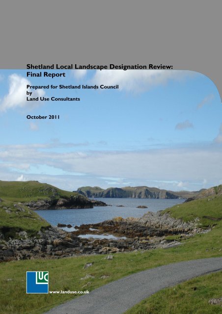
Shetland Local Landscape Designation Review: Final Report
Shetland Local Landscape Designation Review: Final Report
Shetland Local Landscape Designation Review: Final Report

Create successful ePaper yourself
Turn your PDF publications into a flip-book with our unique Google optimized e-Paper software.
<strong>Shetland</strong> <strong>Local</strong> <strong>Landscape</strong> <strong>Designation</strong> <strong>Review</strong>:<br />
<strong>Final</strong> <strong>Report</strong><br />
Prepared for <strong>Shetland</strong> Islands Council<br />
by<br />
Land Use Consultants<br />
October 2011<br />
www.landuse.co.uk
LUC SERVICES<br />
Environmental Planning<br />
<strong>Landscape</strong> Design<br />
<strong>Landscape</strong> Management<br />
Masterplanning<br />
<strong>Landscape</strong> Planning<br />
Ecology<br />
Environmental Assessment<br />
Rural Futures<br />
Digital Design<br />
Urban Regeneration<br />
Urban Design<br />
43 Chalton Street<br />
London NW1 1JD<br />
Tel: 020 7383 5784<br />
Fax: 020 7383 4798<br />
london@landuse.co.uk<br />
14 Great George Street<br />
Bristol BS1 5RH<br />
Tel: 0117 929 1997<br />
Fax: 0117 929 1998<br />
bristol@landuse.co.uk<br />
37 Otago Street<br />
Glasgow G12 8JJ<br />
Tel: 0141 334 9595<br />
Fax: 0141 334 7789<br />
glasgow@landuse.co.uk<br />
28 Stafford Street<br />
Edinburgh EH3 7BD<br />
Tel: 0131 202 1616<br />
edinburgh@landuse.co.uk
DOCUMENT CONTROL SHEET<br />
Version Status: Version Details: Prepared<br />
by:<br />
Checked<br />
by:<br />
Approved<br />
by:<br />
Ver: Date: Principal<br />
1 7/10/2011 Draft <strong>Final</strong> <strong>Report</strong> PDM SCO NJ<br />
2 31/10/2011 <strong>Final</strong> <strong>Report</strong> PDM NJ NJ
CONTENTS<br />
1 EXECUTIVE SUMMARY 1<br />
2 INTRODUCTION 3<br />
Study Context ........................................................................................................ 3<br />
Scottish Planning Policy ......................................................................................................... 3<br />
<strong>Shetland</strong> Policy Context ........................................................................................................ 4<br />
Guidance on <strong>Local</strong> <strong>Landscape</strong> <strong>Designation</strong>s ............................................................................ 4<br />
<strong>Local</strong> <strong>Landscape</strong> Areas .......................................................................................................... 4<br />
Project Aims and Objectives .................................................................................... 5<br />
Study Area ............................................................................................................. 5<br />
Structure of this report ........................................................................................... 5<br />
3 METHODOLOGY 6<br />
Desk <strong>Review</strong> ........................................................................................................................ 6<br />
Audit of Existing <strong>Landscape</strong> <strong>Designation</strong>s ............................................................................... 7<br />
<strong>Landscape</strong> Evaluation ............................................................................................................ 7<br />
Identification of Candidate <strong>Local</strong> <strong>Landscape</strong> Areas ................................................................ 14<br />
Candidate <strong>Local</strong> <strong>Landscape</strong> Areas ........................................................................................ 16<br />
4 PLANNING POLICY CONTEXT 17<br />
National Planning Policy and Advice ....................................................................... 17<br />
National Planning Framework .............................................................................................. 17<br />
Scottish Planning Policy ....................................................................................................... 17<br />
Planning Advice Note 60 ..................................................................................................... 18<br />
Guidance on <strong>Local</strong> <strong>Landscape</strong> <strong>Designation</strong>s .......................................................................... 18<br />
<strong>Local</strong> Planning ....................................................................................................... 18<br />
<strong>Shetland</strong> Structure Plan ....................................................................................................... 19<br />
<strong>Shetland</strong> <strong>Local</strong> Plan ............................................................................................................. 19<br />
<strong>Local</strong> Development Plan ...................................................................................................... 19<br />
Strategy and Guidance ........................................................................................................ 20<br />
Conclusion ........................................................................................................... 20<br />
5 EVIDENCE BASE 22<br />
<strong>Landscape</strong> Character Assessment ........................................................................................ 22<br />
Other Baseline Information ................................................................................................. 24<br />
6 AUDIT OF LANDSCAPE DESIGNATIONS 25<br />
Introduction ......................................................................................................... 25<br />
National Scenic Areas ........................................................................................... 25<br />
Location, extent and boundaries .......................................................................................... 25<br />
Key characteristics and special qualities ................................................................................ 26<br />
<strong>Local</strong> Protection Areas .......................................................................................... 26<br />
Conclusion ........................................................................................................... 27<br />
7 EVALUATION 28<br />
Results by Evaluation Criteria ................................................................................ 28<br />
Representativeness ............................................................................................................. 28<br />
Rarity ................................................................................................................................ 28<br />
Intactness ........................................................................................................................... 28<br />
Scenic qualities ................................................................................................................... 29<br />
i
Enjoyment .......................................................................................................................... 29<br />
Cultural qualities ................................................................................................................ 29<br />
Naturalness ........................................................................................................................ 29<br />
Rural pattern ...................................................................................................................... 30<br />
Views ................................................................................................................................ 30<br />
Weighting ............................................................................................................ 40<br />
Total Scores ......................................................................................................... 40<br />
Area of Search ...................................................................................................... 40<br />
8 IDENTIFICATION OF CANDIDATE LOCAL LANDSCAPE AREAS44<br />
9 CANDIDATE LOCAL LANDSCAPE AREAS 53<br />
Document Information .......................................................................................... 89<br />
TABLES<br />
Table 3.1 Evaluation Criteria ....................................................................................................... 9<br />
Table 3.2 Evaluation questions and decision rules .............................................................. 10<br />
Table 5.1 <strong>Landscape</strong> Character Units .................................................................................... 23<br />
Table 7.1 Evaluation Scores ordered by LUC ...................................................................... 41<br />
Table 7.2 Evaluation Scores ordered by total score ........................................................... 42<br />
Table 8.1 Qualitative Analysis of the Area of Search ......................................................... 45<br />
Table 9.1 Candidate <strong>Local</strong> <strong>Landscape</strong> Areas ......................................................................... 53<br />
FIGURES<br />
Figure 5.1 ..... <strong>Landscape</strong> Classification from <strong>Shetland</strong> <strong>Landscape</strong> Character Assessment<br />
Figure 5.2 ......................................................................................... <strong>Landscape</strong> Character Units<br />
Figure 5.3 ............................. <strong>Landscape</strong> Character Units and the <strong>Landscape</strong> Classification<br />
Figure 5.4 .................................................................................. Cultural Heritage <strong>Designation</strong>s<br />
Figure 5.5 ................................................................................... Natural Heritage <strong>Designation</strong>s<br />
Figure 6.1 ............................................................................................... <strong>Landscape</strong> <strong>Designation</strong>s<br />
Figure 7.1 ....................................................................................................... Representativeness<br />
Figure 7.2 ................................................................................................................................ Rarity<br />
Figure 7.3 ......................................................................................................................... Intactness<br />
Figure 7.4 ............................................................................................................... Scenic qualities<br />
Figure 7.5 ....................................................................................................................... Enjoyment<br />
Figure 7.6 ............................................................................................................ Cultural qualities<br />
Figure 7.7 ..................................................................................................................... Naturalness<br />
Figure 7.8 .................................................................................................................. Rural pattern<br />
Figure 7.9 ................................................................................................................................ Views<br />
Figure 7.10 .................................................................................................................. Total Scores<br />
Figure 7.11 .............................................................................................................. Area of Search<br />
ii
Figure 9.1 ............................................................................. Candidate <strong>Local</strong> <strong>Landscape</strong> Areas<br />
Figure 9.2 ...................................................................................... Candidate Area 1 Ronas Hill<br />
Figure 9.3 .................................................................. Candidate Area 2 Nibon and Mangaster<br />
Figure 9.4 ................................................ Candidate Area 3 Vementry and West Burrafirth<br />
Figure 9.5 ............................................................ Candidate Area 4 Papa Stour and Sandness<br />
Figure 9.6 ............................................................................. Candidate Area 5 Walls and Vaila<br />
Figure 9.7 ......................................................... Candidate Area 6 Culswick and Westerwick<br />
Figure 9.8 ........................................................................................ Candidate Area 7 Weisdale<br />
Figure 9.9 ................................................. Candidate Area 8 Scat Ness and Sumburgh Head<br />
Figure 9.10 .................................................................. Candidate Area 9 No Ness and Mousa<br />
Figure 9.11 ................................................................ Candidate Area 10 Aith Ness and Noss<br />
Figure 9.12 ........................................................... Candidate Area 11 Gletness and Skellister<br />
Figure 9.13 ........................................................ Candidate Area 12 Lunna Ness and Lunning<br />
Figure 9.14 ......................................................................... Candidate Area 13 Wick of Tresta<br />
Figure 9.15 ............................................................ Candidate Area 14 Colvadale and Muness<br />
Figure 9.16 ........................................................... Candidate Area 15 Haroldswick and Skaw<br />
Figure 9.17 ........................................... Candidate Area 16 Gloup Voe and Bluemull Sound<br />
Figure 9.18 ........................................... Candidate Area 17 West Sandwick to Gloup Holm<br />
APPENDICES<br />
Appendix 1 ...................................................................................... Example Field Survey Form<br />
Appendix 2 ................................................................................................. <strong>Landscape</strong> Evaluation<br />
iii
1 Executive Summary<br />
1.1 This report presents the findings of a <strong>Local</strong> <strong>Landscape</strong> <strong>Designation</strong> <strong>Review</strong><br />
(LLDR), carried out by Land Use Consultants on behalf of <strong>Shetland</strong> Islands<br />
Council (SIC).<br />
1.2 Due to changes in national policy, the current suite of <strong>Local</strong> Protection Areas,<br />
defined by the <strong>Shetland</strong> <strong>Local</strong> Plan, are no longer suitable. A new landscapespecific<br />
designation will be introduced as part of the new <strong>Local</strong> Development<br />
Plan, currently being prepared by SIC.<br />
1.3 A methodology for the LLDR was developed, based on the approach set out<br />
in Guidance on <strong>Local</strong> <strong>Landscape</strong> <strong>Designation</strong>s, published jointly by Scottish<br />
Natural Heritage and Historic Scotland in 2005. The methodology was<br />
designed to identify ‘candidate <strong>Local</strong> <strong>Landscape</strong> Areas’, which will be subject<br />
to further consultation by SIC prior to adoption.<br />
1.4 An evaluation of the <strong>Shetland</strong> landscape was undertaken, drawing on the<br />
published landscape character assessment of the area. A series of evaluation<br />
criteria were developed and agreed, and were employed to produce a ranking<br />
of character areas by landscape quality. The evaluation was carried out<br />
initially as a desk-based exercise, and subsequently expanded through field<br />
work. The result of this first stage was the definition of an area of search,<br />
which was agreed with SIC.<br />
1.5 Further field work informed an analysis of the area of search, enabling a move<br />
away from landscape character areas towards candidate <strong>Local</strong> <strong>Landscape</strong><br />
Areas, often focusing on areas of combined character where landscape<br />
qualities are most evident.<br />
1.6 A number of practical criteria were applied, to ensure all candidate <strong>Local</strong><br />
<strong>Landscape</strong> Areas represented coherent, recognisable landscapes, with<br />
appropriate boundaries. The resulting set of candidate <strong>Local</strong> <strong>Landscape</strong><br />
Areas were then submitted to SIC for approval, prior to finalisation of the<br />
report.<br />
1.7 The outcome of the LLDR was a set of 17 candidate <strong>Local</strong> <strong>Landscape</strong> Areas,<br />
representing a series of highly valued and high quality landscapes across<br />
<strong>Shetland</strong>. The candidate areas represent a range of <strong>Shetland</strong>’s landscape<br />
types, and complement the coverage of the <strong>Shetland</strong> National Scenic Area.<br />
1.8 A Statement of Importance has been developed for each candidate <strong>Local</strong><br />
<strong>Landscape</strong> Area, providing a robust justification for its extent and boundaries,<br />
together with its key characteristics, and recommendations for development<br />
guidelines.<br />
1.9 The next stage will be a consultation process, to be taken forward by SIC,<br />
which will seek wider comment on the candidate <strong>Local</strong> <strong>Landscape</strong> Areas.<br />
Appropriate policy to be applied within <strong>Local</strong> <strong>Landscape</strong> Areas will be<br />
formulated by SIC. It is anticipated that the finalised <strong>Local</strong> <strong>Landscape</strong> Areas<br />
will form supplementary planning guidance alongside the forthcoming <strong>Local</strong><br />
Development Plan.<br />
<strong>Shetland</strong> Islands <strong>Local</strong> <strong>Landscape</strong> <strong>Designation</strong> <strong>Review</strong><br />
Land Use Consultants<br />
<strong>Final</strong> <strong>Report</strong> 1 October 2011
Glossary<br />
1.10 This glossary lists acronyms used in the report.<br />
cLLA candidate <strong>Local</strong> <strong>Landscape</strong> Area<br />
LCA <strong>Landscape</strong> Character Assessment<br />
LCU <strong>Landscape</strong> Character Unit<br />
LDP <strong>Local</strong> Development Plan<br />
LLDR <strong>Local</strong> <strong>Landscape</strong> <strong>Designation</strong> <strong>Review</strong><br />
LUC Land Use Consultants<br />
LPA <strong>Local</strong> Protection Area<br />
MIR Main Issues <strong>Report</strong><br />
NNR National Nature Reserve<br />
NPF2 National Planning Framework 2<br />
NSA National Scenic Area<br />
PAN Planning Advice Note<br />
SAC Special Area of Conservation<br />
SIC <strong>Shetland</strong> Islands Council<br />
SNH Scottish Natural Heritage<br />
SoI Statement of Importance<br />
SPA Special Protection Area<br />
SPG Supplementary Planning Guidance<br />
SPP Scottish Planning Policy<br />
SSSI Site of Special Scientific Interest<br />
<strong>Shetland</strong> Islands <strong>Local</strong> <strong>Landscape</strong> <strong>Designation</strong> <strong>Review</strong><br />
Land Use Consultants<br />
<strong>Final</strong> <strong>Report</strong> 2 October 2011
2 Introduction<br />
2.1 Following a change in national planning policy, <strong>Shetland</strong> Islands Council (SIC)<br />
is taking a new approach to the protection of landscape at a local level. At<br />
present, a number of <strong>Local</strong> Protection Areas are designated for a range of<br />
reasons including landscape, biodiversity and archaeology. New national<br />
policy encourages local authorities to employ local designations for distinct<br />
purposes, backed by robust justification. As such, the current multi-purpose<br />
<strong>Local</strong> Protection Areas are no longer suitable. SIC proposes therefore to<br />
develop a new suite of local landscape designations which will accord with<br />
national policy, based on a review of landscape character.<br />
2.2 In April 2011, Land Use Consultants (LUC) was commissioned to undertake<br />
this local landscape designation review (LLDR). LUC’s brief was to develop a<br />
robust set of criteria and carry out a comprehensive assessment aimed at<br />
replacing the current set of designations with a new, more robustly justified<br />
suite of <strong>Local</strong> <strong>Landscape</strong> Areas.<br />
2.3 This report presents the findings of the review process, including a<br />
comparative evaluation of the <strong>Shetland</strong> landscape, and the selection of<br />
candidate <strong>Local</strong> <strong>Landscape</strong> Areas. This report builds on an interim report<br />
(May 2011), which set out the proposed methodology and baseline studies.<br />
This was discussed and agreed with SIC. Key elements of the study, such as<br />
the specific purposes of the new designation, were therefore agreed at the<br />
project outset, in order that the outcome fully reflects SIC’s intentions.<br />
STUDY CONTEXT<br />
Scottish Planning Policy<br />
2.4 In 2010, the Scottish Government published Scottish Planning Policy (SPP),<br />
their updated statement on nationally important land use planning matters.<br />
This includes policy on local designations, and states that “planning authorities<br />
are encouraged to limit non-statutory designations to two types - local landscape<br />
areas and local nature conservation sites” (paragraph 139).<br />
2.5 SPP also recommends that the “reasons for designation should be clearly<br />
explained” (paragraph 139), and states that:<br />
“The purpose of designating a local landscape area in the development plan should<br />
be to:<br />
<br />
<br />
<br />
safeguard and enhance the character and quality of landscapes which are<br />
important or particularly valued locally or regionally, or<br />
promote understanding and awareness of the distinctive character and special<br />
qualities of local landscapes, or<br />
safeguard and promote important settings for outdoor recreation and tourism<br />
locally” (paragraph 140).<br />
2.6 Under the terms of this policy, the <strong>Local</strong> Protection Areas (LPA) identified in<br />
the adopted <strong>Shetland</strong> <strong>Local</strong> Plan (2004) are no longer appropriate, since they<br />
<strong>Shetland</strong> Islands <strong>Local</strong> <strong>Landscape</strong> <strong>Designation</strong> <strong>Review</strong><br />
Land Use Consultants<br />
<strong>Final</strong> <strong>Report</strong> 3 October 2011
are a ‘multi-purpose’ designation. Further details on LPAs are included in<br />
Section 6 of this report.<br />
<strong>Shetland</strong> Policy Context<br />
2.7 SIC are currently working on a new <strong>Local</strong> Development Plan (LDP) to<br />
replace the <strong>Shetland</strong> <strong>Local</strong> Plan. This will introduce a new approach to<br />
planning, replacing the current zones with land allocations, for which<br />
submissions of Proposed Development Sites have already been invited. A<br />
new approach to local landscape protection will therefore integrate with the<br />
new LDP approach.<br />
Guidance on <strong>Local</strong> <strong>Landscape</strong> <strong>Designation</strong>s<br />
2.8 In 2006, Scottish Natural Heritage (SNH) and Historic Scotland jointly<br />
published Guidance on <strong>Local</strong> <strong>Landscape</strong> <strong>Designation</strong>s. This document,<br />
afterwards referred to as ‘the Guidance’ in this report, contains detailed<br />
guidance on undertaking a systematic review of landscape, aimed at identifying<br />
those areas most worthy of designation. The Guidance encourages an ‘alllandscapes’<br />
approach, whereby the value of every landscape is recognised<br />
through criteria-based policies, while those landscapes which merit special<br />
attention are recognised through designation.<br />
2.9 The approach set out in the Guidance has formed the basis for the<br />
methodology used in the present review, and is expanded upon in Section 3<br />
of this report.<br />
<strong>Local</strong> <strong>Landscape</strong> Areas<br />
2.10 SPP uses the term ‘local landscape area’ to refer to a local authority level<br />
landscape protection designation, and this term has therefore been adopted<br />
in the present report.<br />
2.11 Both SPP and the Guidance set out the generic role and purposes of local<br />
landscape areas, although the latter notes that local landscape designations<br />
can serve a variety of roles, and that it is for the local authority to decide on<br />
the specific purpose of any proposed designation. The new <strong>Local</strong> <strong>Landscape</strong><br />
Areas in <strong>Shetland</strong> will be designed to:<br />
<br />
<br />
<br />
offer protection to selected areas from inappropriate scales and types of<br />
development;<br />
extend protection to areas not already afforded significant protection by<br />
national-level landscape and biodiversity designations; and<br />
seek to protect a representative range of the landscapes for which<br />
<strong>Shetland</strong> is renowned, including rural crofting landscapes, as well as the<br />
more dramatic coastal scenery.<br />
2.12 <strong>Local</strong> <strong>Landscape</strong> Areas will not come into force until adopted as part of the<br />
new <strong>Local</strong> Development Plan.<br />
<strong>Shetland</strong> Islands <strong>Local</strong> <strong>Landscape</strong> <strong>Designation</strong> <strong>Review</strong><br />
Land Use Consultants<br />
<strong>Final</strong> <strong>Report</strong> 4 October 2011
PROJECT AIMS AND OBJECTIVES<br />
2.13 The objectives of the local landscape designation review (LLDR) have been<br />
identified by LUC, based on the requirements issued by SIC, as follows:<br />
<br />
<br />
<br />
<br />
<br />
To define and implement a clear methodology for identifying regionally<br />
significant <strong>Local</strong> <strong>Landscape</strong> Areas, based on the approach set out in<br />
Guidance on <strong>Local</strong> <strong>Landscape</strong> <strong>Designation</strong>s;<br />
To assess the whole of the <strong>Shetland</strong> landscape to identify areas that merit<br />
protection, and areas that do not, based on a systematic and transparent<br />
approach for defining proposed areas for designation;<br />
To briefly review the existing suite of LPAs, other designations, and<br />
submitted Proposed Development Sites, and to utilise these to inform an<br />
understanding of the baseline;<br />
To identify through this process a series of ‘candidate <strong>Local</strong> <strong>Landscape</strong><br />
Areas’, which will be the subject of further consultation by SIC;<br />
To provide a Statement of Importance for each candidate area, setting out<br />
full justification for their selection, including description of their character,<br />
qualities and value of the proposed areas, identification of justifiable<br />
boundaries, and an indication of potentially appropriate types and scales of<br />
development; and<br />
To present a detailed report setting out the methodology, assessment and<br />
findings of the review in a clear and transparent way.<br />
2.14 This report does not define or advise on the policy to be applied within <strong>Local</strong><br />
<strong>Landscape</strong> Areas, should they be adopted in future. Applicable policies will<br />
be formulated by SIC.<br />
STUDY AREA<br />
2.15 The study area for the review, as defined by SIC, covers the whole of<br />
<strong>Shetland</strong>, with the exception of the islands of Foula, Fair Isle and Out<br />
Skerries.<br />
STRUCTURE OF THIS REPORT<br />
2.16 The remainder of this report is structured as follows:<br />
<br />
<br />
<br />
<br />
<br />
<br />
<br />
Section 3: Methodology<br />
Section 4: Planning Policy Context<br />
Section 5: Evidence Base<br />
Section 6: Audit of <strong>Landscape</strong> <strong>Designation</strong>s in <strong>Shetland</strong><br />
Section 7: <strong>Landscape</strong> Evaluation<br />
Section 8: Qualitative Analysis<br />
Section 9: Candidate <strong>Local</strong> <strong>Landscape</strong> Areas<br />
<strong>Shetland</strong> Islands <strong>Local</strong> <strong>Landscape</strong> <strong>Designation</strong> <strong>Review</strong><br />
Land Use Consultants<br />
<strong>Final</strong> <strong>Report</strong> 5 October 2011
3 Methodology<br />
3.1 This section describes the methodology adopted in carrying out the local<br />
landscape designation review (LLDR). The approach was guided principally by<br />
Guidance on <strong>Local</strong> <strong>Landscape</strong> <strong>Designation</strong>s 1 , published by SNH and Historic<br />
Scotland, and was developed based on LUC’s past experience in carrying out<br />
designation reviews in Fife, Edinburgh and the Scottish Borders. The<br />
approach was adapted based on the specific requirements of SIC and of the<br />
special character of the <strong>Shetland</strong> landscape.<br />
3.2 The methodology was developed through discussion with SIC over the<br />
course of the project, to ensure its applicability, and to incorporate projectspecific<br />
needs.<br />
3.3 The study comprised the following main tasks:<br />
<br />
<br />
<br />
<br />
<br />
<br />
Desk-based review of background material;<br />
Audit of existing landscape designations;<br />
<strong>Landscape</strong> evaluation, comprising:<br />
<br />
<br />
<br />
<br />
Initial field survey<br />
Preliminary landscape evaluation;<br />
Definition of an ‘area of search’; and<br />
Detailed field survey and finalised evaluation;<br />
Analysis of the ‘area of search’;<br />
Identification of candidate <strong>Local</strong> <strong>Landscape</strong> Areas; and<br />
Draft ‘Statements of Importance’.<br />
Desk <strong>Review</strong><br />
3.4 The first stage was a detailed review of a range of national, regional, and local<br />
planning policy and guidance relating to landscape designations in general, and<br />
to the <strong>Shetland</strong> landscape in particular. The findings of the policy review are<br />
set out in Section 4.<br />
3.5 The principal source of information on the <strong>Shetland</strong> landscape is A <strong>Landscape</strong><br />
Assessment of the <strong>Shetland</strong> Isles, prepared by Gillespies and published in 1998<br />
by SNH. 2 To enable a comparative review of the landscapes of <strong>Shetland</strong>, the<br />
landscape character types and areas were grouped and modified, by LUC, as<br />
part of the current commission, to arrive at a refined classification of 57<br />
‘landscape character units’ (LCU). This process is described in detail in<br />
Section 5.<br />
3.6 Other background data sources were used to inform the evaluation as<br />
follows:<br />
<br />
Aerial photographs;<br />
1 Scottish Natural Heritage/Historic Scotland (2006) Guidance on <strong>Local</strong> <strong>Landscape</strong> <strong>Designation</strong>s.<br />
2 Gillespies (1998) A <strong>Landscape</strong> Assessment of the <strong>Shetland</strong> Isles. Scottish Natural Heritage <strong>Review</strong> No.<br />
93.<br />
<strong>Shetland</strong> Islands <strong>Local</strong> <strong>Landscape</strong> <strong>Designation</strong> <strong>Review</strong><br />
Land Use Consultants<br />
<strong>Final</strong> <strong>Report</strong> 6 October 2011
Ordnance Survey mapping at 1:50,000 and 1:25,000 scale;<br />
Natural heritage designations (National Scenic Areas, National Nature<br />
Reserves, Ramsar sites, Special Areas of Conservation, Special Protection<br />
Areas, Sites of Special Scientific Interest);<br />
Cultural heritage designations (Inventory of Gardens and Designed<br />
<strong>Landscape</strong>s, Scheduled Ancient Monuments, listed buildings);<br />
<strong>Local</strong> designations and policies defined in the <strong>Shetland</strong> <strong>Local</strong> Plan (2004);<br />
and<br />
<br />
Access information (public rights of way, Core Paths).<br />
Audit of Existing <strong>Landscape</strong> <strong>Designation</strong>s<br />
3.7 A brief audit was carried out of the existing suite of local and national<br />
landscape designations in <strong>Shetland</strong>. This focused on the LPA designation, and<br />
sought to identify their purpose, function, reasons for designation, and, where<br />
appropriate, the landscape qualities they embody and aim to protect. A key<br />
feature of the LPAs is their ‘community-led’ focus, whereby suggestions for<br />
potential areas are submitted by <strong>Shetland</strong> residents or community groups.<br />
The LPAs are therefore a potential source of information on the type of<br />
landscapes which are valued locally.<br />
3.8 The audit also looked at the <strong>Shetland</strong> National Scenic Area and its special<br />
qualities as set out in The special qualities of the National Scenic Areas. 3 The<br />
audit is included in Section 6 of this report.<br />
<strong>Landscape</strong> Evaluation<br />
3.9 The main part of the LLDR was the desk-based quantitative evaluation of the<br />
landscape of the study area. The methodology for the evaluation is based on<br />
Guidance on <strong>Local</strong> <strong>Landscape</strong> <strong>Designation</strong>s, and was developed based on LUC’s<br />
past experience, and through consultation with SIC.<br />
Evaluation criteria<br />
3.10 The evaluation was based on the landscape classification set out in A<br />
<strong>Landscape</strong> Assessment of the <strong>Shetland</strong> Isles, as refined for this review (see<br />
Section 5). Each of the landscape character units (LCU) were individually<br />
evaluated against a series of agreed criteria.<br />
3.11 The criteria used are based on those suggested in the Guidance, and further<br />
informed by the requirements of SIC and the needs of the present study.<br />
They were developed into a series of evaluation questions, with four possible<br />
‘ranks’ for each question: low, medium, high or very high. Three additional<br />
non-ranked criteria identify differences in relative value within LCUs, and<br />
important relationships with other LCUs, as well as noting other designations<br />
present in each LCU. The criteria were discussed and agreed with SIC during<br />
the course of the project. The criteria are defined in Table 3.1, and the<br />
evaluation questions and decision rules are set out in Table 3.2.<br />
3 Scottish Natural Heritage (2010). The special qualities of the National Scenic Areas. SNH<br />
Commissioned <strong>Report</strong> No.374.<br />
<strong>Shetland</strong> Islands <strong>Local</strong> <strong>Landscape</strong> <strong>Designation</strong> <strong>Review</strong><br />
Land Use Consultants<br />
<strong>Final</strong> <strong>Report</strong> 7 October 2011
3.12 An interim report (June 2011) presented proposed criteria, which have since<br />
been modified following discussion and initial fieldwork. Significant changes to<br />
the evaluation methodology, between the interim report and this <strong>Final</strong><br />
<strong>Report</strong>, are noted below:<br />
<br />
<br />
<br />
The term ‘typicality’ has been replaced with ‘representativeness’, to<br />
better reflect the evaluation of ‘sense of place’, rather than simply<br />
common landscapes.<br />
The assessment of condition was found to be problematic, as it was<br />
difficult to consistently assess the level of management of the landscape.<br />
Following initial field work, the level of landscape management was not<br />
found to be as important as intactness in determining landscape quality.<br />
The condition criterion has therefore been omitted while the intactness<br />
criterion has been developed further.<br />
The interim report included a ‘value’ criterion, to be assessed through the<br />
presence of existing designations. Following discussion with the Council,<br />
it was decided that this would not produce a consistent evaluation.<br />
Other designations have therefore been recorded as a non-ranked<br />
criterion.<br />
<strong>Shetland</strong> Islands <strong>Local</strong> <strong>Landscape</strong> <strong>Designation</strong> <strong>Review</strong><br />
Land Use Consultants<br />
<strong>Final</strong> <strong>Report</strong> 8 October 2011
Table 3.1 Evaluation Criteria<br />
Criteria<br />
Representativeness<br />
Rarity<br />
Intactness<br />
Scenic qualities<br />
Enjoyment<br />
Cultural qualities<br />
Naturalness<br />
Rural pattern<br />
Views<br />
Non-ranked criteria<br />
<strong>Landscape</strong><br />
consistency<br />
<strong>Landscape</strong><br />
relationships<br />
Other designations<br />
Definition<br />
The extent to which a landscape is representative of the <strong>Shetland</strong> Islands,<br />
and contributes to its wider identity and sense of place.<br />
Identifies landscapes or features which are rare or unusual within the<br />
<strong>Shetland</strong> Islands, or which are known to be uncommon elsewhere.<br />
The extent to which a landscape has changed in the past, or is currently<br />
changing, as a result of development or changing land management.<br />
The extent to which the landscape contains attractive, impressive, and/or<br />
dramatic combinations of features, or to which it prompts strong sensory<br />
appeal.<br />
The importance of the landscape as a recreational resource, including<br />
accessibility and provision of opportunities for appreciation of the landscape<br />
or views.<br />
The extent to which the landscape is the setting for features of historic<br />
value, including buildings, archaeology and designed landscapes. Also<br />
includes the influence of intangible literary or artistic associations.<br />
The importance of features of natural heritage interest within the landscape,<br />
including important habitats, protected sites, and features of geodiversity<br />
value.<br />
The extent to which the landscape allows an appreciation of the traditional<br />
pattern of cultivation and settlement on <strong>Shetland</strong>, and in particular the<br />
distinctive pattern of the crofting landscape.<br />
The extent and importance of views in and out of the landscape, including<br />
the relative visibility of the landscape from key routes and locations.<br />
The extent to which a LCU is consistent in terms of the above criteria.<br />
Identifies the most important adjacent LCUs, which may combine to form<br />
groupings with high value.<br />
Identifies existing designations which cover parts of the LCU, including<br />
LPAs, NSA, and other natural and cultural heritage designations.<br />
<strong>Shetland</strong> Islands <strong>Local</strong> <strong>Landscape</strong> <strong>Designation</strong> <strong>Review</strong><br />
Land Use Consultants<br />
<strong>Final</strong> <strong>Report</strong> 9 October 2011
Table 3.2 Evaluation questions and decision rules<br />
Criteria Evaluation questions Rank<br />
Representativeness<br />
Rarity<br />
Does the landscape contain features or a<br />
combination of features that are representative<br />
of the <strong>Shetland</strong> Islands, and therefore contribute<br />
to its wider identity, image and sense of place<br />
locally, regionally or nationally?<br />
Does the landscape contain features or a<br />
combination of features which are rare or unique<br />
within the <strong>Shetland</strong> Islands, or which are known<br />
to be uncommon elsewhere?<br />
Very high<br />
High<br />
Medium<br />
Low<br />
Very high<br />
High<br />
Medium<br />
Low<br />
Very high<br />
The landscape contains features or combination of features that are highly representative of<br />
the <strong>Shetland</strong> Islands, and has a strong sense of place.<br />
The landscape contains features or combination of features that are representative of the<br />
<strong>Shetland</strong> Islands, and has some sense of place.<br />
The landscape contains occasional features or combination of features that are<br />
representative of the <strong>Shetland</strong> Islands, and has a limited sense of place.<br />
The landscape does not contain features which are representative of the <strong>Shetland</strong> Islands.<br />
Large number of landscape features which are unique within the <strong>Shetland</strong> Islands, and may<br />
be rare across Scotland.<br />
Large number of landscape features which are rare or unique within the <strong>Shetland</strong> Islands.<br />
Some landscape features which are rare or unique within the <strong>Shetland</strong> Islands.<br />
No landscape features which are rare or unique within the <strong>Shetland</strong> Islands.<br />
Recent activity has either not affected this landscape, or has been carried on in a<br />
harmonious way.<br />
Intactness<br />
Scenic qualities<br />
Has the underlying character of the landscape<br />
(either natural or resulting from long-established<br />
management patterns) been obscured by past,<br />
present or future changes in human activity,<br />
including landscape management, patterns of<br />
development or the influence of development?<br />
Or, has such activity been continued in a way<br />
which preserves underlying character?<br />
To what extent is the landscape of scenic value<br />
in its own right or to what extent does it<br />
contribute to the scenic qualities of the wider<br />
area?<br />
High<br />
Medium<br />
Low<br />
Very high<br />
High<br />
Medium<br />
Low<br />
Recent activity may have modified this landscape in limited ways, and the underlying<br />
character remains clear.<br />
Recent activity has modified the underlying character of the landscape, though elements of<br />
its underlying character can be discerned.<br />
The character of the landscape has been extensively modified by recent activity such that its<br />
underlying character has been obscured.<br />
Pleasing combination of features, visual contrasts and/or dramatic elements. Strong visual,<br />
sensory, perceptual and experiential qualities which contribute to the natural beauty and<br />
appreciation of the landscape.<br />
Some pleasing features or combinations of features, visual contrasts and/or dramatic<br />
elements. Visual, sensory, perceptual and experiential qualities which contribute to the<br />
natural beauty and appreciation of the landscape.<br />
Few pleasing features, visual contrasts and/or dramatic elements. Some visual, sensory,<br />
perceptual and experiential qualities. <strong>Landscape</strong> contributes to the setting of an adjacent<br />
area of high landscape quality.<br />
The landscape does not contain pleasing features, visual contrasts and/or dramatic<br />
elements, and lacks visual, sensory, perceptual and experiential qualities.<br />
<strong>Shetland</strong> Islands <strong>Local</strong> <strong>Landscape</strong> <strong>Designation</strong> <strong>Review</strong> Land Use Consultants<br />
<strong>Final</strong> <strong>Report</strong> 10 October 2011
Criteria Evaluation questions Rank<br />
Enjoyment<br />
To what extent is the landscape enjoyed by local<br />
people and visitors, for example in the form of<br />
walking, cycling or horse riding, or in the form of<br />
more formal recreation activities, which are<br />
focused on enjoyment of the landscape?<br />
Very high<br />
High<br />
The landscape is well used, and is very important as a recreational and/or tranquil area.<br />
Extensive provision of access (routes and/or open access), viewpoints, attractions and/or<br />
other recreational facilities.<br />
The landscape is important as a recreational and/or tranquil area. Good provision of<br />
access, viewpoints, attractions and/or other recreational facilities.<br />
Medium<br />
Low<br />
The landscape has some importance as a recreational and/or tranquil area. Some provision<br />
of access, viewpoints, attractions and/or other recreational facilities, potentially less wellused.<br />
The landscape has little or no tranquillity and/or outdoor recreational value. There is little<br />
or no provision of access, viewpoints, attractions and/or other recreational facilities.<br />
Cultural qualities<br />
Does the landscape have historic or cultural<br />
associations, either visible monuments and<br />
landscape patterns, or intangible literature,<br />
music, art, local history or particular spiritual<br />
associations, or does it contribute to the wider<br />
cultural heritage of the area?<br />
Very high<br />
High<br />
Medium<br />
The landscape is very rich in visible features of archaeology and built heritage, and has<br />
strong, direct literary or artistic associations.<br />
The landscape is rich in visible features of archaeology and built heritage, and has some<br />
literary or artistic associations.<br />
The landscape has some visible features of archaeology and built heritage. Literary and<br />
artistic associations less direct.<br />
Low<br />
The landscape has few visible features of archaeology or built heritage, and few or no<br />
literary or artistic associations.<br />
Naturalness<br />
To what extent does the landscape represent a<br />
semi-natural area, indicated by a limited human<br />
presence, and by the contribution of natural<br />
heritage features (biodiversity and geodiversity)<br />
to the landscape?<br />
Very high<br />
High<br />
The landscape has very limited or no human influence, and has extensive areas of seminatural<br />
habitat or important features of geodiversity interest.<br />
The landscape has limited human influence, and has larger areas of semi-natural habitat or<br />
features of geodiversity interest.<br />
Medium<br />
The landscape has some degree of human influence, and semi-natural habitat or features of<br />
geodiversity interest are of less importance.<br />
Low<br />
The landscape has extensive human influence, and few areas of semi-natural habitat or<br />
features of geodiversity interest.<br />
<strong>Shetland</strong> Islands <strong>Local</strong> <strong>Landscape</strong> <strong>Designation</strong> <strong>Review</strong> Land Use Consultants<br />
<strong>Final</strong> <strong>Report</strong> 11 October 2011
Criteria Evaluation questions Rank<br />
Rural pattern<br />
To what extent does the landscape enable the<br />
typical pattern of the traditional <strong>Shetland</strong> crofting<br />
way of life to be appreciated?<br />
Very high<br />
High<br />
Medium<br />
Low<br />
A crofting landscape, with the typical elements of scattered croft houses, stone walls, smallscale<br />
patterns of enclosure, and a mix of arable and grazing land.<br />
The landscape contains some features and elements of the crofting landscape, but its<br />
pattern has been altered.<br />
The landscape contains few features and elements of the crofting landscape, and does not<br />
represent the traditional landscape pattern.<br />
Not a crofting landscape.<br />
Views<br />
Does the landscape provide key views to and<br />
from important built and natural heritage assets,<br />
residential properties, centres of population, or<br />
transport routes?<br />
Very high<br />
High<br />
Medium<br />
The landscape is very important in views from recognised key viewpoints, settlements or<br />
transport routes, and/or includes key landmarks.<br />
The landscape has some importance in views from recognised viewpoints, settlements or<br />
transport routes, and/or includes a key landmark.<br />
The landscape is important in a limited number of views from settlements or transport<br />
routes, and/or includes a local landmark.<br />
Low<br />
The landscape does not perform a key function in relation to views from viewpoints,<br />
settlements, transport routes or landmarks.<br />
Non-ranked criteria<br />
<strong>Landscape</strong><br />
consistency<br />
Does the character or quality vary significantly<br />
across the LCU?<br />
Consistent /<br />
Not consistent<br />
If not consistent, consider subdividing by quality or character, if taken forward for<br />
consideration as a candidate <strong>Local</strong> <strong>Landscape</strong> Area.<br />
<strong>Landscape</strong><br />
relationships<br />
Other<br />
designations<br />
Is the LCU closely associated with surrounding<br />
LCUs? Does it form a ‘gateway’ into another<br />
area?<br />
Any other landscape-scale designations which<br />
cover all or part of the LCU, including:<br />
<strong>Landscape</strong> Protection Areas;<br />
National Scenic Areas;<br />
Natural heritage designations (SPA, SAC,<br />
Ramsar, SSSI, NNR);<br />
Gardens and designed landscapes<br />
List related<br />
landscapes<br />
List relevant<br />
designations<br />
Consider grouping with related LCUs, or parts of LCUs, if taken forward for consideration<br />
as a candidate <strong>Local</strong> <strong>Landscape</strong> Area.<br />
<strong>Shetland</strong> Islands <strong>Local</strong> <strong>Landscape</strong> <strong>Designation</strong> <strong>Review</strong> Land Use Consultants<br />
<strong>Final</strong> <strong>Report</strong> 12 October 2011
Evaluation Process<br />
3.13 The first stage of the evaluation was based on desk study, and on a field<br />
survey of the <strong>Shetland</strong> landscape undertaken in June 2011. An evaluation<br />
sheet for each LCU was completed in during the field survey, to record<br />
justified rankings against each criterion. An example of the field recording<br />
sheet is included in Appendix 1.<br />
3.14 The initial findings arising from this evaluation were converted in to a<br />
numerical ‘score’ for each LCU. A ranking of low=1, medium=2, high=3, very<br />
high=4. A total score can then be derived, and the LCUs ranked in order of<br />
their landscape quality.<br />
3.15 The results of the evaluation were reviewed by SIC who made a number of<br />
detailed comments. These comments, along with further desk study, were<br />
incorporated into a revised evaluation.<br />
3.16 The revised evaluation scores were used to generate an ‘Area of Search’,<br />
based on the highest-scoring 50% of LCUs. While this represents an<br />
arbitrary cut-off, it is unlikely that the best of <strong>Shetland</strong>’s landscapes will be<br />
outside these LCUs.<br />
3.17 To derive the Area of Search, an appropriate weighting was devised and<br />
applied to the evaluation results, to emphasise important criteria. The<br />
weighting was agreed with SIC and is described in detail in Section 7.<br />
3.18 Following a second field survey, carried out in August/September 2011, and<br />
focusing on the Area of Search, the evaluation was refined based on the<br />
additional data gathered. The evaluation was again submitted to SIC for<br />
comment, to enable input of detailed local knowledge prior to finalisation.<br />
The results of the finalised evaluation are discussed in Section 7.<br />
Field Survey<br />
3.19 The first stage of fieldwork (June 2011) gathered basic information on each<br />
LCU, in order to carry out an initial evaluation against the criteria.<br />
3.20 The second field survey (August 2011) comprised a more targeted series of<br />
visits to LCUs within the Area of Search, to gather more detailed evaluation<br />
information, and to identify potential candidate <strong>Local</strong> <strong>Landscape</strong> Areas. <strong>Local</strong><br />
<strong>Landscape</strong> Areas may or may not correspond to LCUs, and therefore the<br />
second survey also looked across LCU boundaries, to identify potential<br />
groupings of landscapes. The second survey also sought also to gather more<br />
specific information on the key qualities to be drafted for each candidate<br />
<strong>Local</strong> <strong>Landscape</strong> Area.<br />
3.21 The survey form for the second stage of the evaluation looked to the<br />
identification of candidate <strong>Local</strong> <strong>Landscape</strong> Areas, and involved the recording<br />
of descriptive prose relating to three aspects:<br />
<br />
<br />
Objective description of landscape features, with reference to landform,<br />
land cover, land use, settlement pattern, distinctive features;<br />
Objective description of visual relationships and contrasts which are<br />
important to the landscape, including relationships between LCUs; and<br />
<strong>Shetland</strong> Islands <strong>Local</strong> <strong>Landscape</strong> <strong>Designation</strong> <strong>Review</strong><br />
Land Use Consultants<br />
<strong>Final</strong> <strong>Report</strong> 13 October 2011
Subjective description or personal response to the landscape.<br />
3.22 This approach draws on the SNH methodology employed in the definition of<br />
special qualities of National Scenic Areas. 4 It seeks to draw out the key<br />
characteristics of an area, which form part of the justification required for<br />
each candidate <strong>Local</strong> <strong>Landscape</strong> Area. The detailed field survey was therefore<br />
an iterative process, designed to verify and expand on the initial stage of the<br />
evaluation. An example of the second-stage field survey form is included in<br />
Appendix 1.<br />
Identification of Candidate <strong>Local</strong> <strong>Landscape</strong> Areas<br />
Analysis of the Area of Search<br />
3.23 The evaluation process looked at each LCU as a whole, but did not seek to<br />
identify variations within these units. The quantitative scoring of LCUs, while<br />
providing a sound basis for selecting the most valuable areas, does not<br />
correlate directly to the definition of candidate <strong>Local</strong> <strong>Landscape</strong> Areas.<br />
3.24 Significant variations in landscape quality occur across LCUs, and as such may<br />
not be brought out by an evaluation process that looks at LCUs as a whole.<br />
Potentially, high-scoring LCUs may contain areas of lower quality, while lower<br />
scoring LCUs may contain features of value. The potential for parts of<br />
neighbouring LCUs combine to form valuable assemblages is also recognised.<br />
Because of these variations, the wholesale adoption of high-scoring LCUs as<br />
candidate <strong>Local</strong> <strong>Landscape</strong> Areas would have been inappropriate.<br />
3.25 In order to refine the Area of Search, a more detailed qualitative analysis was<br />
carried out, to enable a move away from the pre-defined LCUs, towards<br />
potential candidate <strong>Local</strong> <strong>Landscape</strong> Areas.<br />
3.26 This analysis drew on the non-ranked criteria, and on material gathered<br />
during both stages of the field survey work. The following questions were<br />
explored in relation to each of the LCUs in the Area of Search.<br />
<br />
<br />
Which parts of the LCU perform best against the evaluation<br />
criteria?<br />
This question seeks to identify variations in relative landscape quality,<br />
noting which specific locations contribute to the highest rankings. This is<br />
particularly focused on the weighted criteria, and also draws on variations<br />
noted under the non-ranked consistency criterion.<br />
Are there parts of the LCU that contribute to important<br />
composite landscapes?<br />
This question was considered with reference to the non-ranked<br />
relationships criterion, and seeks to identify where adjacent landscapes of<br />
differing type combine to create valuable groupings. It also identifies areas<br />
which may form an important setting to a high-quality landscape. This<br />
included the consideration of areas outside the Area of Search, where<br />
these contributed to the integrity of potential candidate <strong>Local</strong> <strong>Landscape</strong><br />
Areas.<br />
4 SNH (2008) Guidance For Identifying The Special Qualities Of Scotland’s National Scenic Areas.<br />
<strong>Shetland</strong> Islands <strong>Local</strong> <strong>Landscape</strong> <strong>Designation</strong> <strong>Review</strong><br />
Land Use Consultants<br />
<strong>Final</strong> <strong>Report</strong> 14 October 2011
3.27 The result of this step indicates where sub-character areas, of high landscape<br />
quality, occur within LCUs, and whether these can be associated with<br />
adjacent areas in other LCUs to form potential candidate <strong>Local</strong> <strong>Landscape</strong><br />
Areas.<br />
Application of Practical Criteria<br />
3.28 The second part of the analysis of the Area of Search is the application of<br />
‘practical criteria’. The Guidance emphasises the need for ‘integrity’ in terms<br />
of the coherence and size of candidate areas for designation. The following<br />
practical criteria were therefore applied to inform choices over inclusion or<br />
exclusion:<br />
<br />
<br />
<br />
identity and coherence;<br />
suitable size;<br />
other designations; and<br />
boundary features.<br />
3.29 It is important that candidate <strong>Local</strong> <strong>Landscape</strong> Areas represent recognisable<br />
landscape units, with a logical theme or focus: for example a group of hills, a<br />
coastal landscape, or a crofting landscape. Very small areas of identified<br />
quality have not been taken forward in isolation, since it would be impractical<br />
to apply policy at this scale. Similarly, where larger areas of high quality are<br />
identified, the candidate <strong>Local</strong> <strong>Landscape</strong> Areas have been defined to focus on<br />
the core landscapes which most merit designation.<br />
3.30 In terms of other designations, it was agreed with SIC that the new<br />
designation should not overlap with the existing National Scenic Area.<br />
3.31 The aim has been to select strong and permanent boundaries for the<br />
candidate <strong>Local</strong> <strong>Landscape</strong> Areas where possible. These include roads and<br />
tracks, watercourses and water bodies, and coastal features. Other less<br />
permanent features, such as field boundaries, and topographic features such<br />
as ridgelines which define visual envelopes, have also been employed.<br />
3.32 Where there is a lack of obvious boundary features, it has been necessary to<br />
move outwards to the next available boundary, and to include areas of lower<br />
merit, rather than to move inwards and reduce the area of higher merit<br />
included within the candidate <strong>Local</strong> <strong>Landscape</strong> Area, particularly where this<br />
might have an impact on the integrity of the area in question.<br />
3.33 In some cases, the decision as to whether or not to include a specific area<br />
within a candidate <strong>Local</strong> <strong>Landscape</strong> Area was clear cut. However, most of<br />
the landscape is not so easily defined, and landscape quality is often variable at<br />
a detailed level. In many cases therefore, the decision required fine<br />
judgements to be made.<br />
3.34 The process of analysing the Area of Search and identifying candidate <strong>Local</strong><br />
<strong>Landscape</strong> Areas is set out in Section 8.<br />
<strong>Shetland</strong> Islands <strong>Local</strong> <strong>Landscape</strong> <strong>Designation</strong> <strong>Review</strong><br />
Land Use Consultants<br />
<strong>Final</strong> <strong>Report</strong> 15 October 2011
Candidate <strong>Local</strong> <strong>Landscape</strong> Areas<br />
3.35 An initial set of candidate <strong>Local</strong> <strong>Landscape</strong> Areas was presented to SIC for<br />
comment and feedback on:<br />
<br />
<br />
<br />
the appropriateness of the areas selected;<br />
the extent of the overall coverage; and<br />
specific areas included or excluded.<br />
Statements of Importance<br />
3.36 Once the extent of candidate <strong>Local</strong> <strong>Landscape</strong> Areas was agreed with SIC, a<br />
Statement of Importance (SoI) was developed for each. The SoI is designed<br />
to justify the designation, in terms of what it protects and why. The SoI is<br />
divided into four sections:<br />
<br />
<br />
<br />
<br />
Location and boundaries: defines the boundaries of the candidate<br />
<strong>Local</strong> <strong>Landscape</strong> Area;<br />
Key characteristics: a distillation of the special qualities which the<br />
candidate <strong>Local</strong> <strong>Landscape</strong> Area is designed to protect;<br />
<strong>Designation</strong> statement: a detailed description of the candidate <strong>Local</strong><br />
<strong>Landscape</strong> Area, which expands on the reasons for designation in terms of<br />
key themes or qualities;<br />
Development guidelines: outlines potential issues and guidance on<br />
managing future change in a manner which is sympathetic to the special<br />
qualities of the area. These guidelines are not intended to be overly<br />
prescriptive, and do not comment of potential capacity issues. They are<br />
designed to offer general guidance on the types of change which may or<br />
may not be appropriate in each area.<br />
3.37 The finalised candidate <strong>Local</strong> <strong>Landscape</strong> Areas, with statements of<br />
importance, are presented in Section 9.<br />
<strong>Shetland</strong> Islands <strong>Local</strong> <strong>Landscape</strong> <strong>Designation</strong> <strong>Review</strong><br />
Land Use Consultants<br />
<strong>Final</strong> <strong>Report</strong> 16 October 2011
4 Planning Policy Context<br />
4.1 This section gives an overview of relevant national planning policy on local<br />
landscape designations, and reviews related themes in strategic and local<br />
development plans.<br />
NATIONAL PLANNING POLICY AND ADVICE<br />
National Planning Framework<br />
4.2 The National Planning Framework for Scotland 2 (NPF2) 5 celebrates the<br />
diversity and value of Scotland’s landscapes. In particular, it recognises the<br />
role of natural and historic landscapes in creating a sense of place,<br />
contributing to quality of life, and as a rich resource for tourism and leisure,<br />
creative industries, education and national and regional marketing. “Nationally<br />
important landscape characteristics” are recognised, including “openness,<br />
intervisibility, perceived naturalness, and remoteness” (paragraph 97).<br />
4.3 NPF2 also recognises the wide ranging pressures on landscapes and the<br />
resultant changing character, particularly in response to the challenge of<br />
climate change. At the same time, these and other changes offer<br />
opportunities to support landscape enhancement, with the ultimate aim “to<br />
build environmental capital and pass well-managed, high quality landscapes on to<br />
future generations” (paragraph 100).<br />
Scottish Planning Policy<br />
4.4 Scottish Planning Policy 6 (SPP) is the Scottish Government’s policy on<br />
nationally important land use planning matters. The policy outlines the need<br />
for planning authorities to support opportunities for enjoyment and<br />
understanding of the natural heritage, whilst protecting and preserving it.<br />
The policy recognises the dynamic nature of the landscape in countryside and<br />
urban areas and the aim of the policy is to facilitate positive change whilst<br />
maintaining and enhancing its distinctive character.<br />
4.5 SPP notes that “local designations should be clearly identified and protected<br />
through the local development plan” and that “the reasons for designation should<br />
be clearly explained and the on-going relevance and function of local designations<br />
should be considered when development plans are prepared” (paragraph 139). It<br />
identifies that local landscape areas and local nature conservation sites are to<br />
be the only two non-statutory local designations for natural heritage. The<br />
document notes that the purpose for designating a local landscape area<br />
should be to:<br />
<br />
<br />
“Safeguard and enhance the character and quality of landscapes which are<br />
important or particularly valued locally or regionally, or<br />
Promote understanding and awareness of the distinctive character and special<br />
qualities of local landscapes, or<br />
5 Scottish Government (2009) National Planning Framework for Scotland 2.<br />
6 Scottish Government (2010) Scottish Planning Policy.<br />
<strong>Shetland</strong> Islands <strong>Local</strong> <strong>Landscape</strong> <strong>Designation</strong> <strong>Review</strong><br />
Land Use Consultants<br />
<strong>Final</strong> <strong>Report</strong> 17 October 2011
Safeguard and promote important settings for outdoor recreation and tourism<br />
locally” (paragraph 140).<br />
Planning Advice Note 60<br />
4.6 PAN 60: Planning for Natural Heritage 7 provides policy and planning advice<br />
regarding Scotland’s natural heritage. Safeguarding and enhancing landscape<br />
character is an important planning objective. To achieve this there needs to<br />
be clear policy objectives in relation to landscape, promotion of high<br />
standards of siting and use of appropriate materials. A landscape designation<br />
is employed when an area is valued beyond its immediate surroundings.<br />
4.7 <strong>Landscape</strong> designations are stated to be of more value when forming part of a<br />
wider land-use framework and habitat network and contributing to realisation<br />
of national natural heritage strategy (paragraph 39). <strong>Landscape</strong> character<br />
assessment can provide the means of determining the extent of landscapes to<br />
be designated (paragraph 26).<br />
4.8 <strong>Landscape</strong> designations can offer opportunities to develop a partnership<br />
between local authorities and stakeholders. Development guidelines should<br />
be designed to safeguard landscape and should play a supporting role in<br />
protecting designated landscape (paragraph 40).<br />
Guidance on <strong>Local</strong> <strong>Landscape</strong> <strong>Designation</strong>s<br />
4.9 This Guidance 8 was developed by Scottish Natural Heritage (SNH) and<br />
Historic Scotland from a review of local landscape designations initiated in<br />
2003. The Guidance offers advice to local authorities on reviewing their local<br />
landscape designations. It seeks to;<br />
<br />
<br />
<br />
“promote greater understanding and support for local landscape designations<br />
among local authorities, the public and other key stakeholders;<br />
reaffirm the role of local landscape designations as part of an ‘all landscapes’<br />
approach and define the circumstances when they could be used;<br />
secure greater consistency in the selection and use of local landscape<br />
designations by local authorities; and<br />
clarify the relationship of local landscape designations to the wider family of<br />
Scotland’s landscape designations” (paragraph 1-5).<br />
4.10 This guidance forms the basis for the approach to the current study, and is<br />
discussed further in relation to the methodology in Section 3.<br />
LOCAL PLANNING<br />
4.11 The current Development Plan for <strong>Shetland</strong> comprises the <strong>Shetland</strong> Structure<br />
Plan (2000) and the adopted <strong>Shetland</strong> <strong>Local</strong> Plan (2004). These will be<br />
superseded by a new <strong>Local</strong> Development Plan (LDP). This is currently being<br />
prepared by SIC, following the publication of a Main Issues <strong>Report</strong> in March<br />
2010. SIC has also prepared a range of supplementary planning guidance<br />
(SPG) and strategic studies.<br />
7 Scottish Executive (2000) Planning Advice Note 60: Planning for Natural Heritage.<br />
8 Scottish Natural Heritage/Historic Scotland (2006) Guidance on <strong>Local</strong> <strong>Landscape</strong> <strong>Designation</strong>s.<br />
<strong>Shetland</strong> Islands <strong>Local</strong> <strong>Landscape</strong> <strong>Designation</strong> <strong>Review</strong><br />
Land Use Consultants<br />
<strong>Final</strong> <strong>Report</strong> 18 October 2011
<strong>Shetland</strong> Structure Plan<br />
4.12 The <strong>Shetland</strong> Structure Plan was approved in 2001 and sets out the land use<br />
strategy for <strong>Shetland</strong> to 2015. The plan notes that “<strong>Shetland</strong>’s land and sea<br />
resources make up a particularly rich natural environment which is not only of<br />
international significance but forms the foundation for substantial parts of the<br />
<strong>Shetland</strong> economy” (page 8), and one of the key aims of the plan is “to protect<br />
and enhance the natural and built environment” (page 10). Under the heading<br />
The <strong>Shetland</strong> <strong>Landscape</strong> and Design, the structure plan notes that “<strong>Shetland</strong>’s<br />
landscape is one of extensive vistas in which almost every building or development<br />
can be seen” (page 12). Policy SP NE2 gives protection to the National Scenic<br />
Area.<br />
<strong>Shetland</strong> <strong>Local</strong> Plan<br />
4.13 The <strong>Shetland</strong> <strong>Local</strong> Plan was adopted in 2004. “To protect and enhance the<br />
natural and built environment” is again identified as a key aim (page 8), and the<br />
plan recognises that the “landscape heritage of <strong>Shetland</strong> is every bit as important<br />
as that of its music, language, agriculture and fishing traditions” (page 11). Policy<br />
LP NE11 defines <strong>Local</strong> Protection Areas, which are discussed in more detail<br />
in Section 3. Policy LP NE11 will not be taken forward in the new LDP.<br />
<strong>Local</strong> Development Plan<br />
Main Issues <strong>Report</strong><br />
4.14 The first stage of the new <strong>Shetland</strong> <strong>Local</strong> Development Plan (LDP), the Main<br />
Issues <strong>Report</strong> (MIR) was a consultative document which would determine the<br />
direction of the LDP. Its aim was to explore “the ways in which planning can<br />
best deliver the preservation of the natural and built environment of <strong>Shetland</strong><br />
including its rich cultural and landscape heritage and way of life” (page 2).<br />
4.15 Relevant aspects of the local vision for <strong>Shetland</strong> in the MIR include:<br />
<br />
<br />
“Conserving important historic and cultural assets; particularly <strong>Shetland</strong>’s<br />
traditional crofting way of life and traditions”;<br />
“Making sure that new development is environmentally sensitive and of good<br />
quality”; and<br />
“Protecting and enhancing areas for recreation and natural heritage” (page 6).<br />
4.16 Appendix 4 of the MIR confirms that Policy LP NE11, governing <strong>Local</strong><br />
Protection Areas, will not be retained in the <strong>Local</strong> Development Plan.<br />
Call for Proposed Development Sites<br />
4.17 As part of the LDP process, SIC is required to identify areas of land which<br />
will enable the provision of housing and commercial development during the<br />
life of the plan. In order to ensure that any areas allocated for development<br />
are deliverable, SIC asked landowners and developers to propose suitable<br />
sites where land could be developed over a five, ten or 20 year timescale.<br />
4.18 The consultation attracted submissions of 190 sites across <strong>Shetland</strong>, and SIC<br />
subsequently invited public comment on their appropriateness. Sites<br />
considered by SIC to be suitable for development will be included in the LDP.<br />
<strong>Shetland</strong> Islands <strong>Local</strong> <strong>Landscape</strong> <strong>Designation</strong> <strong>Review</strong><br />
Land Use Consultants<br />
<strong>Final</strong> <strong>Report</strong> 19 October 2011
4.19 Although the proposed sites represent an early stage in the process, they<br />
represent an impression of potential areas of development pressure, as well<br />
as areas where development may be taken forward. As such they form a<br />
useful cross-check against the results of the evaluation, although they are not<br />
a formal part of the study baseline.<br />
Strategy and Guidance<br />
4.20 In 2006, SIC published guidelines on landscape and visual impact assessment. 9<br />
These guidelines sought to “highlight the significance of <strong>Shetland</strong>’s landscape<br />
heritage when assessing planning applications. The aim is to ensure that the<br />
landscape and visual impacts of proposals are fully considered in the decisionmaking<br />
process.” The guidelines set out SIC’s preferred approach to<br />
landscape and visual impact assessment, and are based on the foundation that<br />
“<strong>Shetland</strong>’s landscape heritage is unique and should be celebrated” (page 2).<br />
4.21 <strong>Shetland</strong>’s Cultural Strategy 10 also recognises the importance of the islands’<br />
landscape, as part of their distinctive cultural and environmental heritage.<br />
Aim 2.4 of the strategy seeks to “Safeguard, promote and ensure access to the<br />
natural environment of <strong>Shetland</strong> and its outstanding landscape, flora and fauna”<br />
(page 11).<br />
4.22 The methods to achieve this aim are listed as:<br />
<br />
<br />
“Recognise that <strong>Shetland</strong>’s exceptional landscapes and seascapes are among<br />
our strongest assets and ensure that development within them is carefully<br />
considered and appropriate.<br />
Support efforts to have the special qualities of <strong>Shetland</strong>’s natural environment<br />
recognised and promoted, for example through Geopark designation.<br />
Safeguard, promote, and ensure appropriate access to, <strong>Shetland</strong>’s wildlife, sea<br />
life and high quality natural environment.” (page 11)<br />
4.23 A <strong>Landscape</strong> Sensitivity and Capacity Study for Wind Farm Development 11 was<br />
published by SIC in March 2009. The study is intended as a tool to assist<br />
planning officers rather than being a policy document. The report presents<br />
an examination of the landscape of <strong>Shetland</strong> and an assessment of the relative<br />
sensitivity of each landscape character area to wind farm development at a<br />
range of scales. The report identifies ‘visual compartments’ to assist the<br />
process, and presents a series of locational and design guidelines. The<br />
findings indicate that the most sensitive landscapes are coastal areas, while<br />
the least sensitive tend to be inland areas of the Mainland.<br />
CONCLUSION<br />
4.24 This brief survey of planning policy confirms the important role that local<br />
landscape designations can play within an integrated approach to landscape<br />
9 <strong>Shetland</strong> Islands Council (2006) Basic principles of landscape and visual impact assessment for sponsors of<br />
development.<br />
10 <strong>Shetland</strong> Islands Council (2009) On the Cusp... <strong>Shetland</strong>’s Cultural Strategy: A vision for cultural life in<br />
<strong>Shetland</strong> 2009 – 2013.<br />
11 Land Use Consultants (2009) <strong>Shetland</strong> Islands - <strong>Landscape</strong> Sensitivity and Capacity Study for Wind Farm<br />
Development. <strong>Shetland</strong> Islands Council.<br />
<strong>Shetland</strong> Islands <strong>Local</strong> <strong>Landscape</strong> <strong>Designation</strong> <strong>Review</strong><br />
Land Use Consultants<br />
<strong>Final</strong> <strong>Report</strong> 20 October 2011
planning and management. Within <strong>Shetland</strong>, landscape is clearly considered<br />
to be of major importance, and its protection and enhancement has been a<br />
key planning aim. It will continue to be of central importance to the<br />
forthcoming <strong>Local</strong> Development Plan.<br />
<strong>Shetland</strong> Islands <strong>Local</strong> <strong>Landscape</strong> <strong>Designation</strong> <strong>Review</strong><br />
Land Use Consultants<br />
<strong>Final</strong> <strong>Report</strong> 21 October 2011
5 Evidence Base<br />
5.1 This section sets out the landscape baseline for the <strong>Shetland</strong> Islands, and<br />
reviews the sources of information related to the <strong>Shetland</strong> landscape.<br />
Existing landscape designations are discussed in more detail in Section 6.<br />
<strong>Landscape</strong> Character Assessment<br />
5.2 A <strong>Landscape</strong> Assessment of the <strong>Shetland</strong> Isles was prepared by Gillespies and<br />
published in 1998 by SNH. 12 The landscape character assessment (LCA)<br />
presents a detailed review of the evolution of the <strong>Shetland</strong> landscapes, and<br />
classifies those landscapes into seven main landscape character types:<br />
<br />
<br />
<br />
<br />
<br />
<br />
Major Uplands;<br />
Peatland and Moorland;<br />
Undulating Moorland with Lochs;<br />
Inland Valleys;<br />
Farmed and Settled Lowlands and Coast;<br />
Farmed and Settled Voes and Sounds; and<br />
Coastal Edge.<br />
5.3 These seven types are further subdivided into a total of 29 sub-types, each of<br />
which occurs in one or more discrete areas. The landscape classification is<br />
illustrated in Figure 5.1.<br />
5.4 In total, the LCA divides <strong>Shetland</strong> into 276 individual character units, some of<br />
which are very small, while others are relatively extensive. As such, the<br />
existing classification does not represent a satisfactory baseline for the<br />
landscape evaluation process set out in the methodology (Section 2), since it<br />
would be difficult to compare such a large number of areas at such a range of<br />
scales.<br />
5.5 To enable a comparative review of the landscapes of <strong>Shetland</strong>, the landscape<br />
character types and areas within the study area were grouped and modified<br />
to arrive at a refined classification of 52 ‘landscape character units’ (LCU).<br />
This grouping was based primarily on associations of landscape character<br />
types to form geographically discrete units. The ‘visual compartments’<br />
identified in the wind farm sensitivity study have also influenced the process,<br />
particularly in terms of splitting larger areas. These compartments are based<br />
on natural divisions in the landscape, such as ridge lines. Each of the resulting<br />
LCUs has been assigned a number and a locally appropriate name.<br />
5.6 The LCUs were defined largely as a desk study exercise, though their number<br />
and extent was modified slightly following fieldwork. They have been<br />
identified only for the purposes of this study, and are not intended to<br />
supersede the detailed classification presented in the LCA. The LCUs and<br />
their names were reviewed and agreed with SIC.<br />
12 Gillespies (1998) A <strong>Landscape</strong> Assessment of the <strong>Shetland</strong> Isles. Scottish Natural Heritage <strong>Review</strong> No.<br />
93.<br />
<strong>Shetland</strong> Islands <strong>Local</strong> <strong>Landscape</strong> <strong>Designation</strong> <strong>Review</strong><br />
Land Use Consultants<br />
<strong>Final</strong> <strong>Report</strong> 22 October 2011
5.7 LCUs are listed in Table 5.1, and are illustrated in Figure 5.2. Figure 5.3<br />
shows the LCUs overlaid onto the LCA classification for comparison. These<br />
LCUs form the basis of the evaluation, and each unit is assessed against the<br />
criteria set out in Section 3.<br />
Table 5.1 <strong>Landscape</strong> Character Units<br />
No. Name No. Name<br />
1 Burra Firth and Haroldswick 27 Groni Field<br />
2 Valla Field 28 West Burrafirth<br />
3 Belmont to Herma Ness 29 Sandness<br />
4 Baltasound and Hill of 30 Papa Stour<br />
Colvadale<br />
5 Balta to Uyea 31 Gruting Voe and Vaila Sound<br />
6 Gloup Ness 32 Skeld<br />
7 Basta Voe 33 Sandsound<br />
8 Whale Firth and Mid Yell Voe 34 Weisdale Hills<br />
9 North Fetlar 35 Weisdale and Petta Dale<br />
10 South Fetlar 36 Muckla Moor and North<br />
Nesting<br />
11 South Yell Moorland 37 Lunna Ness and Dury Voe<br />
12 Heoga Ness to The Poil 38 Whalsay<br />
13 Copister to Stuis 39 South Nesting Bay<br />
14 Tofts Voe and Dales Voe 40 Wadbister<br />
15 Sullom Voe 41 Tingwall<br />
16 Souther Hill 42 Weisdale Voe and Whiteness<br />
Voe<br />
17 Gluss and Sullom 43 Burra<br />
18 Burravoe 44 Burra Dale<br />
19 North Roe 45 Lerwick<br />
20 Ronas Hill 46 South Bressay<br />
21 White Grunafirth and Tingon 47 North Bressay and Noss<br />
22 Esha Ness and Hillswick 48 Helli Ness to Gulberwick<br />
23 Gunnister 49 Ward of Scousburgh to Quarff<br />
24 Muckle Roe 50 Sandwick<br />
25 Aith Voe and Olna Firth 51 Fitful Head<br />
26 Vementry and Clousta 52 Sumburgh Head<br />
<strong>Shetland</strong> Islands <strong>Local</strong> <strong>Landscape</strong> <strong>Designation</strong> <strong>Review</strong><br />
Land Use Consultants<br />
<strong>Final</strong> <strong>Report</strong> 23 October 2011
Other Baseline Information<br />
5.8 A range of other information was used to inform the evaluation of the<br />
<strong>Shetland</strong> landscapes. The following aspects of the <strong>Shetland</strong> landscape were<br />
investigated:<br />
<br />
Cultural heritage, including Historic Landuse Assessment, scheduled<br />
monuments, Gardens and Designed <strong>Landscape</strong>s, listed buildings, and other<br />
visible features (Figure 5.4);<br />
Natural heritage and biodiversity, including designated sites (Figure 5.5);<br />
<br />
<br />
Geodiversity, including the <strong>Shetland</strong> Geopark and on-site interpretation of<br />
geological sites; and<br />
Recreation, including walking and cycling routes, visitor attractions, tourist<br />
centres, boat trips, and other opportunities for appreciating the landscape<br />
of <strong>Shetland</strong>.<br />
5.9 In each case, it is the contribution of these aspects to an appreciation of the<br />
visible landscape which was the focus.<br />
<strong>Shetland</strong> Islands <strong>Local</strong> <strong>Landscape</strong> <strong>Designation</strong> <strong>Review</strong><br />
Land Use Consultants<br />
<strong>Final</strong> <strong>Report</strong> 24 October 2011
6 Audit of <strong>Landscape</strong> <strong>Designation</strong>s<br />
INTRODUCTION<br />
6.1 This section presents a brief audit of the existing suite of national and local<br />
landscape designations in <strong>Shetland</strong>. <strong>Landscape</strong> designations in <strong>Shetland</strong><br />
comprise one National Scenic Area, and a large number of <strong>Local</strong> Protection<br />
Areas. These are illustrated in Figure 6.1.<br />
NATIONAL SCENIC AREAS<br />
6.2 The <strong>Shetland</strong> National Scenic Area (NSA) is one of 40 NSAs originally<br />
identified by the Countryside Commission for Scotland in their report<br />
Scotland’s Scenic Heritage, and described as being “of unsurpassed attractiveness<br />
which must be conserved as part of our national heritage”. 13 The designation<br />
came into effect in 1980. Recent legislation confirms NSAs as areas “of<br />
outstanding scenic value in a national context”. 14<br />
6.3 NSAs were reviewed by Scottish Natural Heritage (SNH) in the late 1990s,<br />
and this led to a process of identifying ‘special qualities’ for each NSA. This<br />
process was based on a standard methodology, 15 and began in 2007. The<br />
work was published in 2010 as The special qualities of the National Scenic<br />
Areas, 16 and has been referred to in the audit.<br />
Location, extent and boundaries<br />
6.4 The <strong>Shetland</strong> NSA comprises seven separate coastal areas across <strong>Shetland</strong>.<br />
These are:<br />
<br />
<br />
<br />
<br />
<br />
<br />
<br />
Fair Isle, comprising the whole island;<br />
South West Mainland, the largest area, stretching from Fitful Head to the<br />
Deeps and including Burra and Trondra;<br />
Foula, comprising the whole island;<br />
Muckle Roe, comprising the western half of the island;<br />
Eshaness, the south coast from Head of Stanshi to Ness of Hillswick;<br />
Fethaland, the northern part of North Roe and including Uyea; and<br />
Hermaness, including Burra Firth and Muckle Flugga.<br />
6.5 The <strong>Shetland</strong> NSA extends to around 11,600 ha of land in total.<br />
13 Countryside Commission for Scotland (1978) Scotland’s Scenic Heritage.<br />
14 The Planning etc. (Scotland) Act 2006, Section 263A(1).<br />
15 David Tyldesley & Associates (2006). Identifying the Special Qualities of Scotland’s National Scenic Areas.<br />
Scottish Natural Heritage Commissioned <strong>Report</strong> No.255.<br />
16 Scottish Natural Heritage (2010). The special qualities of the National Scenic Areas. SNH<br />
Commissioned <strong>Report</strong> No.374.<br />
<strong>Shetland</strong> Islands <strong>Local</strong> <strong>Landscape</strong> <strong>Designation</strong> <strong>Review</strong><br />
Land Use Consultants<br />
<strong>Final</strong> <strong>Report</strong> 25 October 2011
Key characteristics and special qualities<br />
6.6 The description of the area in Scotland’s Scenic Heritage suggests that “Scenic<br />
interest in <strong>Shetland</strong> is predominantly coastal.” On Fair Isle and Foula, the variety<br />
of coastal landform is highlighted, including cliffs, geos, stacks, skerries, natural<br />
arches, and beaches. The South West Mainland area is also described in<br />
terms of its varied coastal character, with distinctive settlement patterns<br />
identified on Burra and Trondra. It is a “seascape of strong character and<br />
atmosphere in which the constantly changing skies play an important part.” The<br />
more northerly areas are included again for their variety of coastal features,<br />
including the high red sandstone cliffs of Muckle Roe, and the scenic interest<br />
resulting from the northern islands’ complex geology.<br />
6.7 The special qualities report confirms that the areas covered by the NSA<br />
“comprise <strong>Shetland</strong>’s scenic highlights and epitomise the range of coastal forms<br />
varying across the island group” (page 295). The special qualities are listed as:<br />
<br />
<br />
<br />
<br />
<br />
<br />
<br />
<br />
“The stunning variety of the extensive coastline<br />
Coastal views both close and distant<br />
Coastal settlement and fertility within a large hinterland of unsettled moorland<br />
and coast<br />
The hidden coasts<br />
The effects and co-existence of wind and shelter<br />
A sense of remoteness, solitude and tranquillity<br />
The notable and memorable coastal stacks, promontories and cliffs<br />
The distinctive cultural landmarks<br />
Northern light”<br />
6.8 The detail of the report highlights the importance of visual diversity, resulting<br />
from the geological diversity of the coastlines, and the intimate relationship of<br />
land and sea. The importance of settlement pattern and crofting landscapes is<br />
also recognised. Perceptual aspects, arising from the dynamic weather<br />
conditions and general lack of light pollution and air pollution, are also<br />
considered important. Major landmarks include both impressive natural<br />
features (stacks, arches, headlands) and built structures (lighthouses, brochs).<br />
LOCAL PROTECTION AREAS<br />
6.9 As noted in Section 2, <strong>Local</strong> Protection Areas (LPA) are identified by the<br />
<strong>Shetland</strong> <strong>Local</strong> Plan, and are designated under Policy NE11 for a range of<br />
reasons, including landscape, biodiversity, archaeology, and protection of<br />
agricultural land.<br />
6.10 The justification for the policy states that LPAs are “regarded by the local<br />
community as being worthy of protection for a variety of reasons e.g. a viewpoint,<br />
wildlife, wild flowers, local historic interest, open space. The aim of the policy is to<br />
maintain these areas free from development, except that which is for the benefit of<br />
the community as a whole.”<br />
<strong>Shetland</strong> Islands <strong>Local</strong> <strong>Landscape</strong> <strong>Designation</strong> <strong>Review</strong><br />
Land Use Consultants<br />
<strong>Final</strong> <strong>Report</strong> 26 October 2011
6.11 As of 2011, a total of 82 sites were designated under Policy NE11. Most of<br />
the LPAs are between 10 and 100 hectares in area. The three largest areas<br />
are each around 350 hectares. The smallest are less than one hectare.<br />
6.12 Prior to commissioning this review, SIC undertook a consultation exercise,<br />
seeking submissions from the community for new <strong>Local</strong> <strong>Landscape</strong> Areas as<br />
well as new <strong>Local</strong> Nature Conservation Sites. This process attracted ten<br />
submissions, covering 15 individual sites.<br />
6.13 The results of this review have been used as an indicator of the types of<br />
landscape valued locally. It has informed the evaluation process as well as the<br />
selection of boundaries for candidate <strong>Local</strong> <strong>Landscape</strong> Areas.<br />
CONCLUSION<br />
6.14 The National Scenic Area designation offers protection to nationally<br />
significant coastal landscapes across several areas of <strong>Shetland</strong>. However,<br />
there are other locally valued landscapes outside these areas. The existing<br />
suite of LPAs, while varied and in many cases lacking robust justification, give<br />
a useful indication of the types of landscapes which are appreciated by local<br />
communities.<br />
<strong>Shetland</strong> Islands <strong>Local</strong> <strong>Landscape</strong> <strong>Designation</strong> <strong>Review</strong><br />
Land Use Consultants<br />
<strong>Final</strong> <strong>Report</strong> 27 October 2011
7 Evaluation<br />
7.1 This section discusses the findings of the landscape evaluation. The landscape<br />
evaluation process is largely quantitative, and is described in Section 3.<br />
Evaluation sheets for each individual LCU are included in Appendix 2.<br />
RESULTS BY EVALUATION CRITERIA<br />
7.2 The findings have been mapped separately for each of the twelve criteria,<br />
resulting in the series of maps presented in Figures 7.1 to 7.9. The key to<br />
these figures is given below:<br />
Very High<br />
High<br />
Medium<br />
Low<br />
Representativeness<br />
7.3 Many areas were ranked highly against this criterion (Figure 7.1). The<br />
coastal areas were generally rated high, since the varied coastline of <strong>Shetland</strong>,<br />
whether wild and rugged or settled, is distinctive of the islands. <strong>Shetland</strong>’s<br />
sense of place depends strongly on its coastal character, which is expressed in<br />
the majority of LCUs. The only area to be ranked very high was Sandness<br />
(LCU 29), where a range of representative landscape elements are all<br />
present. Moorland areas were generally ranked medium, since these inland<br />
areas are less representative. Unusual landscapes such as Ronas Hill (LCU<br />
20) and the serpentinite landscape of Hill of Colvadale (LCU 4) were also<br />
ranked medium (though they were rated higher for rarity, see below).<br />
Sullom Voe (LCU 15) was the only area to be ranked low, since the largescale<br />
industrial installation does not represent the wider landscape.<br />
Rarity<br />
7.4 The map of rarity rankings (Figure 7.2) indicates a mixed picture. Very high<br />
rankings were assigned to the dramatic cliffs of Esha Ness and Hillswick (LCU<br />
22), Ronas Hill (LCU 20) and the unusual geology of Unst (LCU 1 and 4).<br />
High rarity value was assigned to uncommon landscapes and landscape<br />
features, such as the rugged hills of Vementry (LCU 26), the cliffs of Noss<br />
(LCU 47) and the scattered small islands around Burra (LCU 43). Many<br />
coastal areas were ranked medium, and settled, less dramatic coasts were<br />
rated low, along with many areas of moorland which are not distinguished<br />
from one another.<br />
Intactness<br />
7.5 The most settled and developed areas of <strong>Shetland</strong> can be discerned from the<br />
map of intactness rankings (Figure 7.3). Areas of the South Mainland, where<br />
the majority of settlement is located, and around Sullom Voe, were generally<br />
<strong>Shetland</strong> Islands <strong>Local</strong> <strong>Landscape</strong> <strong>Designation</strong> <strong>Review</strong><br />
Land Use Consultants<br />
<strong>Final</strong> <strong>Report</strong> 28 October 2011
anked low or medium. Most other areas were ranked high, with more<br />
remote, undisturbed areas ranked very high.<br />
Scenic qualities<br />
7.6 Scenic quality across the islands is generally good, though the evaluation<br />
noted variations. The relative rankings shown in Figure 7.4 indicate that<br />
coastal areas were often rated highly. Areas ranked very high coincide with,<br />
but are not limited to, areas within the <strong>Shetland</strong> NSA. Much of Northmavine,<br />
West Mainland, and parts of the east coast were ranked very high, along with<br />
Fetlar and the Yell and Unst coasts. Inland areas, including the homogenous<br />
moorlands, were generally rated medium. The only two LCUs to be ranked<br />
low were the developed areas around Sullom Voe (LCU 15) and Lerwick<br />
(LCU 45).<br />
Enjoyment<br />
7.7 Enjoyment of the landscape in <strong>Shetland</strong> is predominantly informal, with<br />
coastal walks being the most popular means of access, especially in areas of<br />
scenic quality or where specific historic sites are present. The map of<br />
enjoyment rankings (Figure 7.5) reflects this, indicating the reduced rankings<br />
assigned to inaccessible areas. Low rankings were assigned to moorland<br />
areas not used for walking, and to the areas around Sullom Voe (LCU 15 and<br />
14). Very high rankings were assigned to the most popular areas, including<br />
Noss (LCU 47), St Ninian’s Isle (LCU 51), Esha Ness (LCU 22) and Burra<br />
Firth (LCU 1).<br />
Cultural qualities<br />
7.8 There are a large number of sites of cultural heritage importance across<br />
<strong>Shetland</strong>. The nature of these largely prehistoric features often renders them<br />
all but invisible to the untrained eye. The evaluation focused on the visible<br />
cultural dimension of each LCU, and as such many areas were assigned<br />
medium or low rankings, as shown in Figure 7.6. Very high rankings were<br />
assigned to areas where substantial cultural heritage features contributed<br />
visibly by their presence or by association, such as Jarlshof (LCU 52),<br />
Staneydale (LCU 31) and Tingwall (LCU 41). High rankings were assigned<br />
where features of lesser stature indicated time-depth and long-established<br />
settlement.<br />
Naturalness<br />
7.9 Almost all areas scored highly for naturalness, as shown in Figure 7.7. Most<br />
areas of <strong>Shetland</strong> have a high degree of naturalness due to the sparseness of<br />
settlement and infrastructure. Only the most developed areas around Sullom<br />
Voe (LCU 15), Brae, Voe and Aith (LCU 25), and Lerwick (LCU 45, 46 and<br />
48) were ranked low or medium. Uninhabited or inaccessible areas, such as<br />
the north-west coast of Yell, or the moorlands of Northmavine, were ranked<br />
very high.<br />
<strong>Shetland</strong> Islands <strong>Local</strong> <strong>Landscape</strong> <strong>Designation</strong> <strong>Review</strong><br />
Land Use Consultants<br />
<strong>Final</strong> <strong>Report</strong> 29 October 2011
Rural pattern<br />
7.10 The presence of the traditional crofting pattern of the settled <strong>Shetland</strong><br />
landscape, whether active or deserted, varies across the islands, as shown in<br />
the map of the rankings (Figure 7.8). Unsettled moorland areas, while<br />
sometimes forming part of crofting landscape assemblages, were generally<br />
ranked low for this criterion. Medium rankings were assigned to areas where<br />
settlement was limited, or where modern development had begun to obscure<br />
the traditional pattern, such along the east coast of the South Mainland.<br />
Several areas of more intact rural pattern were noted, for example to the<br />
west of South Mainland (LCU 51), on Fetlar (LCU 10) and Bressay (LCU 46),<br />
and around Skeld (LCU 35). The most intact areas, ranked very high, were<br />
in: the west of West Mainland (LCU 29 and 31) where a mix of active and<br />
relict croft patterns make up a valuable assemblage; around Vidlin Voe (LCU<br />
37), where the siting of croft houses on the voe sides is an important feature;<br />
and at Colvadale on Unst (LCU 5), a large-scale relict landscape.<br />
Views<br />
7.11 The visually open nature of much of <strong>Shetland</strong> leads to the rankings of most<br />
areas as high or very high. The map of views (Figure 7.9) shows no low<br />
rankings and only four LCUs rated medium. These are all areas which are<br />
not highly visible from other areas, such as the enclosed valley of Tingwall<br />
(LCU 41) and the island of Whalsay (LCU 38). Prominent hills have been<br />
ranked very high, such as Ronas Hill (LCU 20), the Noup of Noss (LCU 47)<br />
and the Ward of Scousburgh (LCU 49).<br />
<strong>Shetland</strong> Islands <strong>Local</strong> <strong>Landscape</strong> <strong>Designation</strong> <strong>Review</strong><br />
Land Use Consultants<br />
<strong>Final</strong> <strong>Report</strong> 30 October 2011
Figure 7.1: Representativeness<br />
<strong>Shetland</strong> Islands <strong>Local</strong> <strong>Landscape</strong> <strong>Designation</strong> <strong>Review</strong><br />
Land Use Consultants<br />
<strong>Final</strong> <strong>Report</strong> 31 October 2011
Figure 7.2: Rarity<br />
<strong>Shetland</strong> Islands <strong>Local</strong> <strong>Landscape</strong> <strong>Designation</strong> <strong>Review</strong><br />
Land Use Consultants<br />
<strong>Final</strong> <strong>Report</strong> 32 October 2011
Figure 7.3: Intactness<br />
<strong>Shetland</strong> Islands <strong>Local</strong> <strong>Landscape</strong> <strong>Designation</strong> <strong>Review</strong><br />
Land Use Consultants<br />
<strong>Final</strong> <strong>Report</strong> 33 October 2011
Figure 7.4: Scenic qualities<br />
<strong>Shetland</strong> Islands <strong>Local</strong> <strong>Landscape</strong> <strong>Designation</strong> <strong>Review</strong><br />
Land Use Consultants<br />
<strong>Final</strong> <strong>Report</strong> 34 October 2011
Figure 7.5: Enjoyment<br />
<strong>Shetland</strong> Islands <strong>Local</strong> <strong>Landscape</strong> <strong>Designation</strong> <strong>Review</strong><br />
Land Use Consultants<br />
<strong>Final</strong> <strong>Report</strong> 35 October 2011
Figure 7.6: Cultural qualities<br />
<strong>Shetland</strong> Islands <strong>Local</strong> <strong>Landscape</strong> <strong>Designation</strong> <strong>Review</strong><br />
Land Use Consultants<br />
<strong>Final</strong> <strong>Report</strong> 36 October 2011
Figure 7.7: Naturalness<br />
<strong>Shetland</strong> Islands <strong>Local</strong> <strong>Landscape</strong> <strong>Designation</strong> <strong>Review</strong><br />
Land Use Consultants<br />
<strong>Final</strong> <strong>Report</strong> 37 October 2011
Figure 7.8: Rural pattern<br />
<strong>Shetland</strong> Islands <strong>Local</strong> <strong>Landscape</strong> <strong>Designation</strong> <strong>Review</strong><br />
Land Use Consultants<br />
<strong>Final</strong> <strong>Report</strong> 38 October 2011
Figure 7.9: Views<br />
<strong>Shetland</strong> Islands <strong>Local</strong> <strong>Landscape</strong> <strong>Designation</strong> <strong>Review</strong><br />
Land Use Consultants<br />
<strong>Final</strong> <strong>Report</strong> 39 October 2011
WEIGHTING<br />
7.12 In order to reflect the importance of those criteria which are most influential<br />
in the perception of ‘special landscapes’, a system of weighting was developed.<br />
Three criteria were given additional weight, as follows:<br />
<br />
The rarity criterion was double-weighted, as a characteristic of special<br />
landscapes; and<br />
The scenic qualities, and views criteria were triple-weighted, as these<br />
were seen as the most significant qualities in terms of the perception of<br />
landscapes.<br />
7.13 These criteria were agreed with SIC following a number of trials with<br />
alternative weightings. It was notable that broadly similar results were<br />
obtained regardless of the weighting applied, with the same core areas<br />
scoring continuously highly.<br />
TOTAL SCORES<br />
7.14 A combined map was prepared using the total weighted score for each LCU.<br />
These were calculated by assigning a value of 1 to a ‘low’ evaluation, and 4 to<br />
a ‘very high’ evaluation for non-weighted criteria. These numbers were<br />
doubled or tripled for the weighted criteria noted above.<br />
7.15 The weighted scores have a possible range of between 14 and 56, though<br />
most areas scored between 30 and 50. Scores for each area are set out in<br />
Table 7.1 (ordered by LCU number) and Table 7.2 (ordered by total<br />
score). The total scores are illustrated on Figure 7.10.<br />
7.16 Esha Ness and Hillswick (22) was the single highest-scoring LCU, with 51<br />
points, followed by Gunnister (23) and North Bressay and Noss (47) each<br />
with 49 points. Areas in or adjacent to the NSAs make up the majority of<br />
the highest scoring areas.<br />
7.17 The lowest-scoring landscape was Sullom Voe (15) with 24 points, followed<br />
by Gluss and Sullom (17) with 27 points. Both of these areas are affected by<br />
the large-scale industrial development at Sullom Voe oil terminal. Other<br />
lower-scoring areas included the less remarkable moorland areas on the<br />
Mainland and Yell.<br />
AREA OF SEARCH<br />
7.18 The highest-scoring LCUs in the evaluation process form the Area of Search<br />
for candidate <strong>Local</strong> <strong>Landscape</strong> Areas. It was agreed with SIC that the highestscoring<br />
50% of LCUs would form the Area of Search, to be examined in<br />
greater detail at the next stage. While this is recognised as an arbitrary cutoff,<br />
it is considered that the very best of the <strong>Shetland</strong> landscapes, ie those<br />
that most merit designation, will be found within these LCUs.<br />
7.19 29 LCUs were selected to form the Area of Search, being those that scored<br />
40 points or more in the final evaluation, representing slightly more than 50%.<br />
These LCUs are highlighted in bold text in Table 7.2, and are illustrated in<br />
Figure 7.11.<br />
<strong>Shetland</strong> Islands <strong>Local</strong> <strong>Landscape</strong> <strong>Designation</strong> <strong>Review</strong><br />
Land Use Consultants<br />
<strong>Final</strong> <strong>Report</strong> 40 October 2011
Table 7.1 Evaluation Scores ordered by LUC<br />
Representativeness<br />
LCU<br />
No. LCU Name<br />
TOTAL<br />
1 Burra Firth and Haroldswick 3 8 2 12 4 4 3 3 9 48<br />
2 Valla Field 3 4 3 6 3 1 4 2 9 35<br />
3 Belmont to Herma Ness 3 2 3 12 2 4 4 3 9 42<br />
4 Baltasound and Hill of Colvadale 2 8 3 9 4 2 4 2 9 43<br />
5 Balta to Uyea 3 6 3 9 2 3 3 4 9 42<br />
6 Gloup Ness 3 4 3 12 3 2 4 3 9 43<br />
7 Basta Voe 3 2 2 6 1 1 3 2 9 29<br />
8 Whale Firth and Mid Yell Voe 3 4 3 9 2 2 4 3 9 39<br />
9 North Fetlar 3 4 3 12 3 2 4 1 9 41<br />
10 South Fetlar 3 6 3 12 3 3 3 3 9 45<br />
11 South Yell Moorland 3 6 4 6 2 1 4 1 9 36<br />
12 Heoga Ness to The Poil 3 4 3 9 3 2 3 3 12 42<br />
13 Copister to Stuis 3 4 3 12 3 2 3 3 12 45<br />
14 Tofts Voe and Dales Voe 3 4 2 6 1 1 3 1 9 30<br />
15 Sullom Voe 1 4 1 3 1 2 2 1 9 24<br />
16 Souther Hill 2 2 2 6 2 1 3 1 12 31<br />
17 Gluss and Sullom 3 2 2 6 2 1 3 2 6 27<br />
18 Burravoe 3 4 3 12 3 2 4 3 12 46<br />
19 North Roe 2 6 3 12 3 2 4 1 9 42<br />
20 Ronas Hill and Ronas Voe 2 8 3 12 3 1 4 2 12 47<br />
21 White Grunafirth and Tingon 2 4 3 6 2 2 4 2 6 31<br />
22 Esha Ness and Hillswick 3 8 3 12 4 3 4 2 12 51<br />
23 Gunnister 3 6 4 12 2 3 4 3 12 49<br />
24 Muckle Roe 3 4 3 12 3 2 4 2 12 45<br />
25 Aith Voe and Olna Firth 3 2 3 6 3 2 2 2 9 32<br />
26 Vementry and Clousta 3 6 4 12 2 2 4 2 12 47<br />
27 Groni Field 2 2 3 9 2 2 4 1 9 34<br />
28 West Burrafirth 3 6 4 12 2 2 4 2 9 44<br />
29 Sandness 4 4 3 9 3 3 3 4 9 42<br />
30 Papa Stour 3 6 4 12 3 3 4 3 9 47<br />
31 Gruting Voe and Vaila Sound 3 4 3 9 3 4 3 4 9 42<br />
32 Skeld 3 4 3 12 3 3 4 3 9 44<br />
33 Sandsound 3 2 3 9 3 3 3 3 9 38<br />
34 Weisdale Hills 2 2 3 6 2 1 4 1 9 30<br />
35 Weisdale and Petta Dale 2 6 3 9 2 2 4 1 9 38<br />
36 Muckla Moor and North Nesting 2 2 3 6 1 1 4 1 9 29<br />
37 Lunna Ness and Dury Voe 3 4 3 12 3 3 3 4 12 47<br />
38 Whalsay 3 6 3 9 3 2 3 2 6 37<br />
Rarity (x2)<br />
Intactness<br />
Scenic Value (x3)<br />
Enjoyment<br />
Cultural qualities<br />
Natural qualities<br />
Rural pattern<br />
Views (x3)<br />
<strong>Shetland</strong> Islands <strong>Local</strong> <strong>Landscape</strong> <strong>Designation</strong> <strong>Review</strong><br />
Land Use Consultants<br />
<strong>Final</strong> <strong>Report</strong> 41 October 2011
Representativeness<br />
LCU<br />
No. LCU Name<br />
TOTAL<br />
39 South Nesting Bay 3 4 4 9 3 1 4 3 9 40<br />
40 Wadbister 3 4 2 6 2 2 3 2 9 33<br />
41 Tingwall 3 4 3 9 3 4 3 2 6 37<br />
42 Weisdale Voe and Whiteness Voe 3 6 2 12 3 3 3 2 12 46<br />
43 Burra 3 6 3 12 3 3 4 3 9 46<br />
44 Burra Dale 2 4 2 6 1 1 4 1 12 33<br />
45 Lerwick 3 6 1 3 3 4 1 1 9 31<br />
46 South Bressay 3 2 2 6 3 3 2 3 12 36<br />
47 North Bressay and Noss 3 6 3 12 4 3 4 2 12 49<br />
48 Helli Ness to Gulberwick 3 2 2 9 2 1 2 2 9 32<br />
49 Ward of Scousburgh to Quarff 2 2 2 6 1 1 3 1 12 30<br />
50 Sandwick 3 2 2 9 3 4 4 2 12 41<br />
51 Fitful Head 3 6 3 12 4 3 3 3 9 46<br />
52 Sumburgh Head 3 4 1 9 3 4 3 2 12 41<br />
Rarity (x2)<br />
Intactness<br />
Scenic Value (x3)<br />
Enjoyment<br />
Cultural qualities<br />
Natural qualities<br />
Rural pattern<br />
Views (x3)<br />
Table 7.2 Evaluation Scores ordered by total score<br />
Representativeness<br />
LCU<br />
No. LCU Name<br />
TOTAL<br />
22 Esha Ness and Hillswick 3 8 3 12 4 3 4 2 12 51<br />
23 Gunnister 3 6 4 12 2 3 4 3 12 49<br />
47 North Bressay and Noss 3 6 3 12 4 3 4 2 12 49<br />
1 Burra Firth and Haroldswick 3 8 2 12 4 4 3 3 9 48<br />
20 Ronas Hill and Ronas Voe 2 8 3 12 3 1 4 2 12 47<br />
26 Vementry and Clousta 3 6 4 12 2 2 4 2 12 47<br />
30 Papa Stour 3 6 4 12 3 3 4 3 9 47<br />
37 Lunna Ness and Dury Voe 3 4 3 12 3 3 3 4 12 47<br />
18 Burravoe 3 4 3 12 3 2 4 3 12 46<br />
42 Weisdale Voe and Whiteness Voe 3 6 2 12 3 3 3 2 12 46<br />
43 Burra 3 6 3 12 3 3 4 3 9 46<br />
51 Fitful Head 3 6 3 12 4 3 3 3 9 46<br />
10 South Fetlar 3 6 3 12 3 3 3 3 9 45<br />
13 Copister to Stuis 3 4 3 12 3 2 3 3 12 45<br />
24 Muckle Roe 3 4 3 12 3 2 4 2 12 45<br />
28 West Burrafirth 3 6 4 12 2 2 4 2 9 44<br />
32 Skeld 3 4 3 12 3 3 4 3 9 44<br />
Rarity (x2)<br />
Intactness<br />
Scenic Value (x3)<br />
Enjoyment<br />
Cultural qualities<br />
Natural qualities<br />
Rural pattern<br />
Views (x3)<br />
<strong>Shetland</strong> Islands <strong>Local</strong> <strong>Landscape</strong> <strong>Designation</strong> <strong>Review</strong><br />
Land Use Consultants<br />
<strong>Final</strong> <strong>Report</strong> 42 October 2011
Representativeness<br />
LCU<br />
No. LCU Name<br />
TOTAL<br />
4 Baltasound and Hill of Colvadale 2 8 3 9 4 2 4 2 9 43<br />
6 Gloup Ness 3 4 3 12 3 2 4 3 9 43<br />
3 Belmont to Herma Ness 3 2 3 12 2 4 4 3 9 42<br />
5 Balta to Uyea 3 6 3 9 2 3 3 4 9 42<br />
12 Heoga Ness to The Poil 3 4 3 9 3 2 3 3 12 42<br />
19 North Roe 2 6 3 12 3 2 4 1 9 42<br />
29 Sandness 4 4 3 9 3 3 3 4 9 42<br />
31 Gruting Voe and Vaila Sound 3 4 3 9 3 4 3 4 9 42<br />
9 North Fetlar 3 4 3 12 3 2 4 1 9 41<br />
50 Sandwick 3 2 2 9 3 4 4 2 12 41<br />
52 Sumburgh Head 3 4 1 9 3 4 3 2 12 41<br />
39 South Nesting Bay 3 4 4 9 3 1 4 3 9 40<br />
8 Whale Firth and Mid Yell Voe 3 4 3 9 2 2 4 3 9 39<br />
33 Sandsound 3 2 3 9 3 3 3 3 9 38<br />
35 Weisdale and Petta Dale 2 6 3 9 2 2 4 1 9 38<br />
38 Whalsay 3 6 3 9 3 2 3 2 6 37<br />
41 Tingwall 3 4 3 9 3 4 3 2 6 37<br />
11 South Yell Moorland 3 6 4 6 2 1 4 1 9 36<br />
46 South Bressay 3 2 2 6 3 3 2 3 12 36<br />
2 Valla Field 3 4 3 6 3 1 4 2 9 35<br />
27 Groni Field 2 2 3 9 2 2 4 1 9 34<br />
40 Wadbister 3 4 2 6 2 2 3 2 9 33<br />
44 Burra Dale 2 4 2 6 1 1 4 1 12 33<br />
25 Aith Voe and Olna Firth 3 2 3 6 3 2 2 2 9 32<br />
48 Helli Ness to Gulberwick 3 2 2 9 2 1 2 2 9 32<br />
16 Souther Hill 2 2 2 6 2 1 3 1 12 31<br />
21 White Grunafirth and Tingon 2 4 3 6 2 2 4 2 6 31<br />
45 Lerwick 3 6 1 3 3 4 1 1 9 31<br />
14 Tofts Voe and Dales Voe 3 4 2 6 1 1 3 1 9 30<br />
34 Weisdale Hills 2 2 3 6 2 1 4 1 9 30<br />
49 Ward of Scousburgh to Quarff 2 2 2 6 1 1 3 1 12 30<br />
7 Basta Voe 3 2 2 6 1 1 3 2 9 29<br />
36 Muckla Moor and North Nesting 2 2 3 6 1 1 4 1 9 29<br />
17 Gluss and Sullom 3 2 2 6 2 1 3 2 6 27<br />
15 Sullom Voe 1 4 1 3 1 2 2 1 9 24<br />
Rarity (x2)<br />
Intactness<br />
Scenic Value (x3)<br />
Enjoyment<br />
Cultural qualities<br />
Natural qualities<br />
Rural pattern<br />
Views (x3)<br />
<strong>Shetland</strong> Islands <strong>Local</strong> <strong>Landscape</strong> <strong>Designation</strong> <strong>Review</strong><br />
Land Use Consultants<br />
<strong>Final</strong> <strong>Report</strong> 43 October 2011
8 Identification of Candidate <strong>Local</strong> <strong>Landscape</strong><br />
Areas<br />
8.1 The next stage of the process looks in more detail within the LCUs which<br />
make up the Area of Search. In order to move from character-based LCUs,<br />
to quality-based candidate <strong>Local</strong> <strong>Landscape</strong> Areas (cLLA), a two stage analysis<br />
was undertaken. The first stage identifies specific areas and groups of areas<br />
which perform well in terms of the evaluation criteria. The second stage<br />
involves applying practical criteria to produce suitable candidate areas for<br />
designation.<br />
8.2 These two stages are described in detail in Section 3, and the findings are<br />
presented in Table 8.1.<br />
<strong>Shetland</strong> Islands <strong>Local</strong> <strong>Landscape</strong> <strong>Designation</strong> <strong>Review</strong><br />
Land Use Consultants<br />
<strong>Final</strong> <strong>Report</strong> 44 October 2011
Table 8.1 Identification of cLLAs within the Area of Search<br />
LCU<br />
No.<br />
LCU Name<br />
Which parts of the LCU performs<br />
best against the evaluation criteria?<br />
Are there parts of the LCU that<br />
contribute to important composite<br />
landscapes?<br />
Application of practical criteria<br />
(coherence, size, other<br />
designations, boundaries)<br />
Conclusion<br />
1 Burra Firth and<br />
Haroldswick<br />
3 Belmont to Herma<br />
Ness<br />
4 Baltasound and Hill<br />
of Colvadale<br />
The coastal parts of this LCU scored<br />
highly, particularly those within the NSA.<br />
The inland area around Haroldswick and<br />
Valsgarth does not have the drama of<br />
the coast, though the rarity value of this,<br />
Britain’s most northerly area, is<br />
recognised<br />
The northern and southern extents of<br />
this area were felt to be the most<br />
visually interesting, and are also the<br />
most accessible parts, viewed by many<br />
visitors to Unst. Belmont House and<br />
Blue Mull are significant features in the<br />
south, while Herma Ness and Muckle<br />
Flugga form a focal point in the north<br />
Several of the high scores assigned to<br />
this LCU can be attributed to the Keen<br />
of Hamar, and its unusual serpentine<br />
landscape which also occurs on the less<br />
accessible Hill of Colvadale. The area<br />
around Baltasound is more affected by<br />
modern development and has less scenic<br />
appeal<br />
5 Balta to Uyea This area scores highly against a range of<br />
criteria, with particular value being<br />
assigned to the area around Sandwick<br />
and Colvadale, which scored highly for<br />
naturalness and scenic quality. The<br />
extensive relict crofting landscape of<br />
Colvadale also scores highly for rarity<br />
and rural pattern. The Uyea area was<br />
not considered to be of such high quality<br />
The peninsula between Burra Firth and<br />
Harold’s Wick stands alone, though the<br />
cliffs on the east side of Burra Firth have<br />
a strong relationship with Herma Ness<br />
in the NSA<br />
The relationship between south-west<br />
Unst and north-east Yell across Bluemull<br />
Sound is important. From Yell, Valla<br />
Field is a visual backdrop<br />
The Hill of Colvadale is important as the<br />
backdrop to the east coast of Unst.<br />
Elsewhere there are visual relationships<br />
with other parts of the wider Unst<br />
landscape, but the inland parts of the<br />
LCU do not contribute to areas of high<br />
landscape quality<br />
The bay between Mu Ness and Huney is<br />
a self-contained landscape, backed by the<br />
Hill of Colvadale. The south coast of<br />
this LCU has a relationship with islands<br />
to the south, but not with other inland<br />
parts of Unst<br />
The western edge is within an NSA.<br />
The north-eastern part of the LCU is<br />
considered to be a coherent area, with<br />
the B9086 as the most appropriate<br />
boundary feature, defining an area<br />
between the NSA and Harold’s Wick<br />
The northern area is within an NSA.<br />
The southern areas are closely<br />
associated with Yell, including the<br />
western slopes of Valla Field. This ridge<br />
line and the A968 form suitable inland<br />
boundaries<br />
The Keen of Hamar is a small area, and<br />
is already protected as a NNR at a<br />
national level. The south-western part<br />
of the area forms part of a coherent<br />
landscape between Mu Ness and Huney,<br />
with the ridge line of Hill of Colvadale<br />
forming a visual boundary. The eastern<br />
areas of the LCU are part of the wider<br />
Unst landscape<br />
The area between Mu Ness and Huney<br />
represents a coherent area of highquality<br />
landscape. Suitable boundaries<br />
were found in the ridge of Hill of<br />
Colvadale, which forms a visual edge,<br />
and along minor roads and field<br />
boundaries to the south<br />
The north-eastern part of<br />
the LCU is proposed as<br />
cLLA 15<br />
The southern part of the<br />
LCU is included in cLLA<br />
16, along with part of<br />
LCU 6 Gloup Ness, and a<br />
small part of LCU 2 Valla<br />
Field<br />
The south-western edge<br />
of this LCU is included in<br />
cLLA 14, along with part<br />
of LCU 5<br />
The central part of this<br />
LCU, covering the east<br />
coast of Unst, is included<br />
in cLLA 14 along with part<br />
of LCU 4<br />
<strong>Shetland</strong> Islands <strong>Local</strong> <strong>Landscape</strong> <strong>Designation</strong> <strong>Review</strong> Land Use Consultants<br />
<strong>Final</strong> <strong>Report</strong> 45 October 2011
LCU<br />
No.<br />
LCU Name<br />
Which parts of the LCU performs<br />
best against the evaluation criteria?<br />
Are there parts of the LCU that<br />
contribute to important composite<br />
landscapes?<br />
Application of practical criteria<br />
(coherence, size, other<br />
designations, boundaries)<br />
Conclusion<br />
6 Gloup Ness This area scores very highly for<br />
naturalness and scenic quality, being a<br />
remote and wild stretch of dramatic<br />
<strong>Shetland</strong> coastline, particularly to the<br />
west. The north-eastern area also<br />
scored highly for its attractive rural<br />
pattern<br />
9 North Fetlar The exposed north coast of the island<br />
scores highly for its scenic qualities, and<br />
undisturbed natural character<br />
10 South Fetlar The southern part of the island scored<br />
highly across all criteria, with the beach,<br />
settlement and headland around Tresta<br />
and Lamb Hoga forming a particularly<br />
attractive and diverse assemblage<br />
12 Heoga Ness to The<br />
Poil<br />
This area scored most highly for its<br />
views, particularly from the south-east<br />
promontory looking south along<br />
<strong>Shetland</strong> and east to Fetlar. It was also<br />
considered to have high scenic qualities,<br />
though these were found to be varied<br />
across the area. The various qualities of<br />
this landscape are not concentrated in<br />
any one area, and are interspersed with<br />
areas of lesser quality<br />
13 Copister to Stuis This area scores very highly for views<br />
and scenic qualities. The northern area,<br />
though less visible from the A968, is<br />
wilder, and is also less affected by the<br />
intrusion of the busy road. The area<br />
around West Sandwick combines many<br />
of the best features of this area<br />
There is a strong association between<br />
the north-east area of Yell and the ridge<br />
of Valla Field on Unst, across Bluemull<br />
Sound. The western coast is more<br />
visually isolated, though it continues in a<br />
similar character south of the Nev of<br />
Stuis<br />
The northern coast is relatively isolated<br />
from the more settled southern part of<br />
the island and there are no associations<br />
with other LCUs<br />
The isolated nature of the Wick of<br />
Tresta is one of its special attributes<br />
This area on the south-east of Yell does<br />
not have strong relationships with other<br />
landscapes, aside from the moorland<br />
which forms a backdrop to the coastal<br />
strip<br />
The moorland of Yell forms the<br />
backdrop to this coastal landscape,<br />
which continues in a similar character<br />
north of Whale Firth. There is a visual<br />
relationship with Fethaland across Yell<br />
Sound, but this area is distant<br />
LCU 6 does not form a coherent area in<br />
itself. The settled north-east part of the<br />
LCU, and south-west Unst, together<br />
form a visually contained area. The<br />
wilder western coast continues south<br />
beyond Stuis. The ridge west of Gloup<br />
Voe divides the settled and unsettled<br />
areas<br />
It was considered that a cLLA covering<br />
the whole island was not appropriate,<br />
and that the range of special qualities of<br />
Fetlar were better represented by the<br />
southern area<br />
The area around Wick of Tresta forms a<br />
coherent and recognisable area<br />
Though there are pockets of high quality<br />
landscape in this LCU, none were<br />
considered to form coherent areas of<br />
suitable size for designation<br />
The A968 was considered to detract<br />
from the southern part of this area. The<br />
coast north of West Sandwick is of high<br />
quality, remote, and forms part of the<br />
wider setting of the Fethaland NSA<br />
The north east part of<br />
LCU 6 is included in cLLA<br />
16 with part of LCU 2.<br />
The western part is<br />
included in cLLA 17 with<br />
part of LCU 13.<br />
No proposal<br />
The core area around<br />
Wick of Tresta is<br />
proposed as cLLA 13<br />
No proposal<br />
The area between West<br />
Sandwick and Nev of Stuis<br />
is included in cLLA 17,<br />
with part of LCU 6 Gloup<br />
Ness<br />
<strong>Shetland</strong> Islands <strong>Local</strong> <strong>Landscape</strong> <strong>Designation</strong> <strong>Review</strong> Land Use Consultants<br />
<strong>Final</strong> <strong>Report</strong> 46 October 2011
LCU<br />
No.<br />
LCU Name<br />
Which parts of the LCU performs<br />
best against the evaluation criteria?<br />
Are there parts of the LCU that<br />
contribute to important composite<br />
landscapes?<br />
Application of practical criteria<br />
(coherence, size, other<br />
designations, boundaries)<br />
Conclusion<br />
18 Burravoe This area was rated very highly for its<br />
scenic quality and views, as well as<br />
naturalness. These qualities were<br />
primarily found at the northern tip,<br />
including the prominent Ramna Stacks<br />
which form a landmark in views around<br />
Yell Sound<br />
19 North Roe This vast empty area of Northmavine<br />
scored very highly for its undisturbed<br />
naturalness and its wild drama. The<br />
coastal areas as well as the open moors<br />
were considered scenic, though with<br />
different qualities<br />
20 Ronas Hill and<br />
Ronas Voe<br />
22 Esha Ness and<br />
Hillswick<br />
The red granite peak scored very highly<br />
against several criteria, including rarity,<br />
scenic qualities and naturalness. These<br />
qualities are apparent on Ronas Hill<br />
itself, along the sea coast and into the<br />
long Ronas Voe, though they are less<br />
pronounced in the eastern part of the<br />
voe<br />
The dramatic coastal landscape of this<br />
area scored highly across almost all<br />
criteria. The two headlands are the<br />
focus of the particular qualities of the<br />
area, offering very high scenic quality,<br />
and impressive views<br />
The northern parts of this area are<br />
associated with the coastline to the<br />
west, along the northern edge of North<br />
Roe. The landscape is visually<br />
connected with Yell across Yell Sound.<br />
Further south, the Beorgs of Skelberry<br />
form the backdrop to the lower-lying<br />
settled parts of the LCU<br />
This area is related to Ronas Hill which<br />
rises up to the south. The east-facing<br />
Beorgs of Skelberry form the setting of<br />
the settlement of North Roe<br />
Moorland to the south of Ronas Voe<br />
forms the setting of the hill, while to the<br />
north, the foothills merge into the lower<br />
rocky moorland and lochans of North<br />
Roe<br />
The key visual relationships are across St<br />
Magnus Bay. The headlands of this LCU<br />
stand alone, though the intervening<br />
section of coast is strongly linked to the<br />
moorland of LCU 21<br />
The areas of highest quality within this<br />
LCU are already protected as part of the<br />
<strong>Shetland</strong> NSA. The remaining areas are<br />
not considered to represent a coherent<br />
high quality landscape suitable for<br />
designation<br />
The northern coast is already protected<br />
as part of the <strong>Shetland</strong> NSA. The<br />
southern area forms part of the foothills<br />
of the visually important Ronas Hill. The<br />
chain of lochans along the Burn of<br />
Roerwater form a suitable boundary<br />
This major landmark and the voe to the<br />
south, together with the foothills to the<br />
north, form a coherent area of suitable<br />
size. The ridge to the south of Ronas<br />
Voe, and the A970, form appropriate<br />
boundaries<br />
Almost all of this area, including all of<br />
the most dramatic coastal areas, is<br />
already protected as part of the <strong>Shetland</strong><br />
NSA. The remaining area does not<br />
represent a coherent landscape suitable<br />
for designation<br />
No proposal<br />
The southern part of the<br />
LCU is included in cLLA<br />
1, along with LCU 20<br />
The majority of this area<br />
is proposed as cLLA 1,<br />
along with the southern<br />
part of LCU 19<br />
No proposal<br />
<strong>Shetland</strong> Islands <strong>Local</strong> <strong>Landscape</strong> <strong>Designation</strong> <strong>Review</strong> Land Use Consultants<br />
<strong>Final</strong> <strong>Report</strong> 47 October 2011
LCU<br />
No.<br />
LCU Name<br />
Which parts of the LCU performs<br />
best against the evaluation criteria?<br />
Are there parts of the LCU that<br />
contribute to important composite<br />
landscapes?<br />
Application of practical criteria<br />
(coherence, size, other<br />
designations, boundaries)<br />
Conclusion<br />
23 Gunnister The indented coast of this LCU, backed<br />
by rugged uneven hills, has high visual<br />
diversity and scores highly against<br />
several criteria. The A970 locally<br />
reduces the intactness, and the inland<br />
area is considered less scenic. Mavis<br />
Grind contributes to rarity value<br />
24 Muckle Roe This area scores very highly for its<br />
dramatic coastal scenery and<br />
uninterrupted naturalness. This value is<br />
concentrated in the wilder, more rugged<br />
west of the island. The more settled<br />
eastern part of the island is less visually<br />
diverse, though it does offer views of the<br />
Mainland<br />
26 Vementry and<br />
Clousta<br />
This LCU scores highly against several<br />
criteria, due to its rugged landform and<br />
highly complex coastline. These<br />
qualities are noted throughout the LCU,<br />
which is consistent in character<br />
28 West Burrafirth The northern part of this LCU has<br />
greater visual interest and diversity,<br />
arising from its rugged landform and<br />
complex coastline. The southern part,<br />
comprising open moorland, contributes<br />
less to the high scores attributed to this<br />
LCU<br />
This coastal landscape forms part of a<br />
wider series of landscapes around St<br />
Magnus Bay. On a local scale, the<br />
northern headland, Ness of Hamar, is<br />
part of the setting of Ness of Hillswick<br />
across Ura Firth. To the south a similar<br />
character extends along the west coast<br />
of Muckle Roe<br />
The west-facing cliffs contribute to the<br />
array of rugged landscapes around St<br />
Magnus Bay. To the east, the island<br />
forms part of the wider setting of Busta<br />
Voe and Olna Firth<br />
The rugged coastal character continues<br />
to the west, along the West Mainland<br />
peninsula. The two LCUs meet across<br />
the long inlet of Brindister Voe. There is<br />
a wider relationship with other coastal<br />
landscapes around St Magnus Bay<br />
The rugged coastline continues eastward<br />
across Brindister Voe into LCU 26,<br />
without a notable change in character.<br />
There is also a wider relationship with<br />
other landscapes around St Magnus Bay.<br />
The southern part of the LCU forms<br />
part of the open inland landscape of<br />
West Mainland<br />
The A970 forms a suitable boundary for<br />
an area covering the coastal part of this<br />
LCU, relating to the NSA to the west<br />
and south. The narrow neck of Mavis<br />
Grind is included, though the rock<br />
cuttings on the A970 to the south are<br />
not. Ridgelines and watercourses form<br />
the north and south boundaries<br />
The western part of the island is within<br />
the <strong>Shetland</strong> NSA, including over half of<br />
its area. The designation protects the<br />
key qualities of this island. The eastern<br />
area, outside the NSA, is not considered<br />
to have a high level of landscape quality<br />
suitable for designation<br />
This area is consistent, but extends<br />
westward without a break in character.<br />
Uniting this LCU with the similar parts<br />
of LCU 28 results in a coherent area of<br />
similar character and high quality. In<br />
order to include all areas of this<br />
landscape, the boundary follows a series<br />
of water bodies including Loch of<br />
Clousta and Forse Water<br />
The northern part of this area is<br />
consistent with LCU 26 to the east, and<br />
the two areas have therefore been<br />
united to form a coherent area. Suitable<br />
physical boundary features are lacking in<br />
this landscape. A boundary has been<br />
suggested, which links a series of lochans<br />
around the south of the rugged hills<br />
The area west of the<br />
A970 is proposed as cLLA<br />
2<br />
No proposal<br />
The area is proposed,<br />
along with part of LCU<br />
28, as cLLA 3<br />
The northern part of the<br />
area is included, along<br />
with LCU 26, as cLLA 3<br />
<strong>Shetland</strong> Islands <strong>Local</strong> <strong>Landscape</strong> <strong>Designation</strong> <strong>Review</strong> Land Use Consultants<br />
<strong>Final</strong> <strong>Report</strong> 48 October 2011
LCU<br />
No.<br />
LCU Name<br />
Which parts of the LCU performs<br />
best against the evaluation criteria?<br />
Are there parts of the LCU that<br />
contribute to important composite<br />
landscapes?<br />
Application of practical criteria<br />
(coherence, size, other<br />
designations, boundaries)<br />
Conclusion<br />
29 Sandness The settled parts of this area, including<br />
Sandness and Dale of Walls, scored<br />
highly against several criteria, and very<br />
highly for their intact settlement pattern.<br />
These areas are considered to be<br />
representative of the <strong>Shetland</strong> rural<br />
landscape. The open moorland between<br />
these areas contributes less to the high<br />
scores attributed to this LCU<br />
30 Papa Stour This area scores highly against all<br />
criteria. The variation in character<br />
between the wilder west coast and the<br />
settled eastern part is noted, but all<br />
areas are considered to contribute to<br />
the rankings<br />
31 Gruting Voe and<br />
Vaila Sound<br />
This large area scores highly against a<br />
range of criteria. There are prominent<br />
cultural features, and the settled areas<br />
around Vaila Sound rank highly for their<br />
rural pattern. The Vaila Sound area is<br />
considered to be more visually diverse<br />
than the area around Gruting Voe,<br />
which is less intricate. The open coastal<br />
edge is more dramatic<br />
Dale of Walls is physically isolated,<br />
looking west to distant Foula. To the<br />
south, the moorland forms part of the<br />
wider West Mainland landscape, and<br />
serves as the setting for settlement to<br />
the south. Sandness Hill forms the<br />
backdrop in views from Papa Stour<br />
The low-lying island, particularly at the<br />
south and east, has a strong visual<br />
relationship with the nearby area of<br />
West Mainland, particularly Sandness<br />
Hill which is prominent and forms a<br />
visual backdrop to the settled coast<br />
around Sandness<br />
There is no clear association between<br />
this and other LCUs, though Ward of<br />
Culswick in LCU 32 is prominent in<br />
some eastward views. To the north the<br />
moorland merges with the wider West<br />
Mainland landscape<br />
The Dale of Walls area, though<br />
performing well in terms of the criteria,<br />
was not considered to be of a suitable<br />
size for designation, and does not group<br />
with other areas. The Sandness area is<br />
larger, and has a strong visual<br />
relationship with the island of Papa<br />
Stour. The ridge of Sandness Hill<br />
provides a suitable visual boundary<br />
The island is a coherent area, but has a<br />
strong visual relationship with Sandness<br />
Hill. In order to protect the setting of<br />
Papa Stour the island has been joined<br />
with the northern area of LCU 29<br />
The area around Vaila Sound represents<br />
the most appealing part of this LCU, and<br />
forms a visually coherent area, focused<br />
on Vaila. Unclassified roads form<br />
suitable boundaries, enclosing the setting<br />
of Vaila Sound to north and east, and<br />
including the shoreline of Walls. To the<br />
west, in order to include the Hill of<br />
Scarvister, the western boundary follows<br />
a minor road and watercourse at<br />
Skarpigarth<br />
The settled area north of<br />
Sandness Hill is proposed<br />
as part of cLLA 4<br />
The island is proposed as<br />
part of cLLA 4<br />
The southern part of the<br />
area, including Vaila and<br />
Vaila Sound is proposed<br />
as cLLA 5<br />
<strong>Shetland</strong> Islands <strong>Local</strong> <strong>Landscape</strong> <strong>Designation</strong> <strong>Review</strong> Land Use Consultants<br />
<strong>Final</strong> <strong>Report</strong> 49 October 2011
LCU<br />
No.<br />
LCU Name<br />
Which parts of the LCU performs<br />
best against the evaluation criteria?<br />
Are there parts of the LCU that<br />
contribute to important composite<br />
landscapes?<br />
Application of practical criteria<br />
(coherence, size, other<br />
designations, boundaries)<br />
Conclusion<br />
32 Skeld The coastal parts of this LCU score<br />
highly for their naturalness and scenic<br />
value. These varied coastal features,<br />
including the cove of Wester Wick,<br />
Stead of Culswick and Skeld Voe, are<br />
scenically diverse. The inland moorland<br />
contributes less to the rankings, though<br />
the importance of Ward of Culswick as<br />
a landmark is noted<br />
37 Lunna Ness and<br />
Dury Voe<br />
This LCU scores particularly highly for<br />
scenic quality and rural pattern, with the<br />
area around Vidlin Voe being<br />
referenced. The Lunna Ness peninsula<br />
contributes to high rankings for natural<br />
and cultural qualities, and views. The<br />
diversity of the long headland, settled<br />
bay, and rugged hills around Lunning is<br />
noted. The southern area around Dury<br />
Voe contributes less to the rankings for<br />
this area<br />
39 South Nesting Bay The coastal setting is the most<br />
important aspect of this landscape,<br />
contributing to high scores for scenic<br />
quality, views, and naturalness. The area<br />
around Gletness is noted for its greater<br />
intricacy and visual diversity<br />
The area is linked to the similar intricate<br />
coast to the south of Vaila to the west,<br />
and which continues around the Deeps<br />
to the east, with views to the many<br />
islands in this area. To the north the<br />
open moorland merges with the wider<br />
West Mainland landscape<br />
This peninsular area extends away from<br />
the Mainland, and is not associated with<br />
outlying islands, though there are visual<br />
relationships with Whalsay and the<br />
smaller islands in Lunning Sound<br />
The headland of Gletness is associated<br />
with other headlands around Cat Firth<br />
and Lax Firth, although these areas are<br />
of lesser visual interest and do not<br />
represent an important landscape group<br />
The south-eastern edge of this LCU is<br />
already protected as part of the <strong>Shetland</strong><br />
NSA. The intricate coast and the<br />
traditional settlement patterns in the<br />
south of the LCU, which are currently<br />
outside the NSA, form a coherent area<br />
for designation. The B9071, along with<br />
the summit of Ward of Culswick, defines<br />
the northern extent of this high quality<br />
part of the LCU<br />
The two contrasting headlands either<br />
side of Vidlin Voe form a coherent area<br />
for designation, defined to the west by<br />
roads, except for field boundaries at<br />
Vidlin to include all of the settlement<br />
setting<br />
The headland area, taking in Gletness,<br />
Skellister and Benston, forms a coherent<br />
landscape, with the inclusion of the area<br />
west of Loch of Benston. The B9075<br />
forms a suitable boundary along the<br />
inland edge of this headland<br />
The south-western area<br />
of this LCU is proposed<br />
as cLLA 6<br />
Lunna Ness and the<br />
headland to the south of<br />
Vidlin Voe are proposed<br />
as cLLA 12<br />
The headland between<br />
Cat Firth and South<br />
Nesting Bay, including a<br />
small part of LCU 41, is<br />
proposed as cLLA 11<br />
<strong>Shetland</strong> Islands <strong>Local</strong> <strong>Landscape</strong> <strong>Designation</strong> <strong>Review</strong> Land Use Consultants<br />
<strong>Final</strong> <strong>Report</strong> 50 October 2011
LCU<br />
No.<br />
LCU Name<br />
Which parts of the LCU performs<br />
best against the evaluation criteria?<br />
Are there parts of the LCU that<br />
contribute to important composite<br />
landscapes?<br />
Application of practical criteria<br />
(coherence, size, other<br />
designations, boundaries)<br />
Conclusion<br />
42 Weisdale Voe and<br />
Whiteness Voe<br />
The LCU scores highly for most criteria,<br />
particularly scenic quality and views,<br />
most clearly arising from the long<br />
headlands to the south. Although the<br />
busy A971 loops through a relatively<br />
developed landscape to the north, this<br />
makes the area more visible, and enables<br />
open views of the dramatic Weisdale<br />
Voe. Whiteness Voe is more hidden<br />
and contributes less significantly to the<br />
area’s high rankings. The Weisdale area<br />
is also the setting for several visitor<br />
attractions<br />
43 Burra This area scores highly across all criteria.<br />
The scatter of islands and their<br />
interrelationships across the area<br />
provide the basis for most of these high<br />
rankings<br />
47 North Bressay and<br />
Noss<br />
The LCU scores highly against a range of<br />
criteria. Noss contributes to very high<br />
scores for scenic quality, enjoyment and<br />
naturalness. The Noup of Noss is an<br />
important landmark of eastern <strong>Shetland</strong>,<br />
visible along the length of the coast. The<br />
northern and eastern parts of Bressay<br />
contribute to high cultural and scenic<br />
scores<br />
The head of Weisdale Voe forms an<br />
important part of the setting of the NSA<br />
to the south. There is no break in<br />
landscape quality at the NSA boundary,<br />
though the linear enclosure of the voe<br />
becomes more apparent. This visual<br />
enclosure extends north into Weisdale,<br />
forming a complete assemblage of glacial<br />
valley and flooded voe<br />
The islands group with the steep<br />
western slopes of the South Mainland to<br />
form a composite landscape of islands<br />
and voes, backed by hills<br />
The north-eastern part of Bressay is<br />
important to the setting of Noss, and as<br />
the main approach. The two islands<br />
form a group, though the southern and<br />
western sides of Bressay are more<br />
developed, and more closely linked to<br />
Lerwick<br />
The southern part of the LCU is already<br />
protected as part of the <strong>Shetland</strong> NSA.<br />
The area around Weisdale Voe forms an<br />
important part of the setting to the<br />
NSA, including long views into the<br />
designated area. In order to define a<br />
coherent area, the settled part of<br />
Weisdale was included, covering the<br />
main visitor attractions in the area, as<br />
well as the unusual woodland<br />
plantations. Ridges to the east and west<br />
form visual boundaries, and the B road<br />
to the north marks the boundary<br />
between settled valley landscape and<br />
open moorland<br />
Almost all of this LCU is already<br />
protected as part of the <strong>Shetland</strong> NSA.<br />
The remaining area, around Scalloway, is<br />
less intact, and does not represent a<br />
coherent landscape suitable for<br />
designation<br />
The island of Noss clearly merits<br />
designation under the criteria, though it<br />
is small. Including the eastern part of<br />
Bressay recognises the interrelationship<br />
between the islands. Suitable<br />
boundaries on Bressay include minor<br />
roads, tracks, ridgelines and<br />
watercourses<br />
The area around Weisdale<br />
Voe, along with the east<br />
edge of LCU 34, and the<br />
south-west part of LCU<br />
35, is proposed as cLLA 7<br />
No proposal<br />
The eastern part of the<br />
area, including Noss, is<br />
proposed as cLLA 10<br />
<strong>Shetland</strong> Islands <strong>Local</strong> <strong>Landscape</strong> <strong>Designation</strong> <strong>Review</strong> Land Use Consultants<br />
<strong>Final</strong> <strong>Report</strong> 51 October 2011
LCU<br />
No.<br />
LCU Name<br />
Which parts of the LCU performs<br />
best against the evaluation criteria?<br />
Are there parts of the LCU that<br />
contribute to important composite<br />
landscapes?<br />
Application of practical criteria<br />
(coherence, size, other<br />
designations, boundaries)<br />
Conclusion<br />
50 Sandwick This area scores particularly highly for<br />
both cultural and natural qualities, largely<br />
represented by Mousa, which is both a<br />
bird reserve and a historic site. Mousa<br />
is also a landmark on this stretch of<br />
coast. These qualities are reflected in<br />
the unsettled No Ness peninsula which<br />
faces Mousa, though the majority of the<br />
LCU scores less highly, and contributes<br />
to the lower intactness score<br />
51 Fitful Head This south-west part of the Mainland<br />
scores highly across all criteria,<br />
particularly scenic qualities, which reside<br />
in the varied coastal landscape. The area<br />
contains visible crofting patterns as well<br />
as natural undisturbed areas. The coast<br />
of this area performs best against the<br />
criteria, though the inland areas also<br />
contribute<br />
52 Sumburgh Head This landscape scores highly for its<br />
visibility and views, and for its cultural<br />
heritage qualities. The southern tip of<br />
Sumburgh Head is an important <strong>Shetland</strong><br />
landmark, particularly for those arriving<br />
or departing from Sumburgh Airport.<br />
The developed area around the airport<br />
contributes to the area’s low intactness<br />
score, though there are a number of<br />
important attractions in the area<br />
The area forms part of a continuous<br />
landscape of more or less settled coast<br />
which stretches from Sumburgh to<br />
Lerwick. The peninsula area of this LCU<br />
extends outward, away from this and<br />
other landscapes, although the No Ness<br />
peninsula and Mousa form an association<br />
This area does not form clear<br />
associations with other landscapes,<br />
though it forms part of the wider South<br />
Mainland peninsula, backed by Ward of<br />
Scousburgh, and continuing northward<br />
towards Burra and Trondra<br />
Sumburgh Head and Scat Ness extends<br />
out from the southern tip of <strong>Shetland</strong>,<br />
and are not closely associated with<br />
other areas of high landscape value<br />
Mousa alone, though performing well<br />
against the criteria, would not be large<br />
enough to warrant designation.<br />
Grouped with No Ness, the area<br />
becomes more substantial, representing<br />
the links between Mainland and island.<br />
Minor roads form a suitable boundary<br />
across the top of No Ness<br />
Around half of this LCU, including most<br />
of the coast, is already protected as part<br />
of the <strong>Shetland</strong> NSA. The remaining<br />
area does not represent a coherent<br />
landscape suitable for designation<br />
The key area of this LCU is south of the<br />
airport, though the airport area is not<br />
suitable for designation, due to its level<br />
of development. The A970 has<br />
therefore been selected as the<br />
boundary, excluding the airport but<br />
including Sumburgh Head, Jarlshof and<br />
Scat Ness<br />
No Ness and Mousa<br />
proposed as cLLA 9<br />
No proposal<br />
The southern headlands<br />
are proposed as cLLA 8<br />
<strong>Shetland</strong> Islands <strong>Local</strong> <strong>Landscape</strong> <strong>Designation</strong> <strong>Review</strong> Land Use Consultants<br />
<strong>Final</strong> <strong>Report</strong> 52 October 2011
9 Candidate <strong>Local</strong> <strong>Landscape</strong> Areas<br />
9.1 Following the analysis and the application of practical criteria, a total of 17<br />
candidate <strong>Local</strong> <strong>Landscape</strong> Areas (cLLA) were identified. These are listed in<br />
Table 9.1 and illustrated in Figure 9.1.<br />
Table 9.1 Candidate <strong>Local</strong> <strong>Landscape</strong> Areas<br />
No. Name LCUs Area (ha)<br />
1 Ronas Hill 19,20 4,238<br />
2 Nibon and Mangaster 23 2,508<br />
3 Vementry and West Burrafirth 26,28 3,602<br />
4 Papa Stour and Sandness 29,30 1,919<br />
5 Walls and Vaila 31 1,294<br />
6 Culswick and Westerwick 32 1,404<br />
7 Weisdale 35,42 1,125<br />
8 Scat Ness and Sumburgh Head 52 272<br />
9 No Ness and Mousa 50 381<br />
10 Aith Ness and Noss 47 1,084<br />
11 Gletness and Skellister 39 1,077<br />
12 Lunna Ness and Lunning 37 2,161<br />
13 Wick of Tresta 10 504<br />
14 Colvadale and Muness 4,5 956<br />
15 Haroldswick and Skaw 1 1,869<br />
16 Gloup Voe and Bluemull Sound 3,6 2,161<br />
17 West Sandwick to Gloup Holm 6,13 1,844<br />
9.2 The area of each cLLA is given in Table 9.1, to the nearest hectare. In total,<br />
these 17 cLLAs cover 28,399 ha, equating to around 19% of the land area of<br />
<strong>Shetland</strong>. In addition to the 11,600 ha covered by the NSA, a total of around<br />
27% of the land area of <strong>Shetland</strong> would be subject to some level of landscape<br />
protection, if all the candidate areas are taken forward.<br />
9.3 Statements of Importance for each cLLA are presented in this section.<br />
Detailed maps of the individual cLLAs are included as Figures 9.2 to 9.18.<br />
<strong>Shetland</strong> Islands <strong>Local</strong> <strong>Landscape</strong> <strong>Designation</strong> <strong>Review</strong><br />
Land Use Consultants<br />
<strong>Final</strong> <strong>Report</strong> 53 October 2011
Candidate <strong>Local</strong> <strong>Landscape</strong> Area 1: Ronas Hill<br />
Location and boundaries:<br />
This area covers Ronas Hill in Northmavine, along with the long, curving Ronas Voe to the south.<br />
It includes the foothills of Ronas Hill stepping down to the sea to the west, and the rocky<br />
moorland to the north and east, as well as both sides of Ronas Voe.<br />
The north boundary of this area follows a chain of lochs and the Burn of Roerwater from the<br />
coast at Lang Clodie Wick to the A970. The eastern boundary follows the A970 as far as<br />
Swinister. The southern boundary runs along the ridgeline to the south of Ronas Voe, including<br />
the visual envelope of the voe. These boundaries enclose the setting of hill and voe, and<br />
represent the most suitable physical and visual boundaries available.<br />
Key characteristics:<br />
<br />
<br />
<br />
<br />
A <strong>Shetland</strong> landmark, the highest point of the islands<br />
Distinctive red granite geology is clearly expressed<br />
Largely empty, uninhabited hills and moors<br />
Rocky plateau, steep cliffs, and other rugged features<br />
<strong>Designation</strong> statement:<br />
Ronas Hill is a <strong>Shetland</strong> landmark, distinctive as the highest point on the islands. It is widely<br />
visible from locations to the south and west, though its true size, relative to the generally lowlying<br />
<strong>Shetland</strong> Islands, is only apparent closer to. The hill has a distinctive red colour derived<br />
from its granite geology. Ronas Hill is the main peak of a broad, rounded ridge running east to<br />
west, and topped by an expansive rocky plateau. This gravelly granite surface features unusual<br />
alpine plant communities, which occur here at exceptionally low altitudes. The plateau falls away<br />
to the north, giving way to lochans and blanket bog. The hill offers wide views across the whole<br />
of <strong>Shetland</strong>, and is a popular destination for hill-walkers visiting <strong>Shetland</strong>. The chambered cairn at<br />
the summit makes for a destination, as well as speaking of the long-established human presence,<br />
even in the remotest parts of <strong>Shetland</strong>. The masts on Collafirth Hill are a reminder of more<br />
modern human influence, but otherwise this is an empty landscape, without settlement except<br />
for properties along the A970.<br />
Ronas Voe to the south is deep and broad, a dramatic fjord-like inlet with tall cliffs of pink granite<br />
and green grass on its northern shore. These colourful cliffs are at their most imposing from<br />
Heylor on the south shore. Falling steeply into the water, their feet are fringed by narrow<br />
reddish ayres derived from the granite. Small burns tumble down incised gullies in the cliffs, and<br />
remnants of willow scrub can be seen. The eastern voe is less dramatic, with disused dwellings<br />
visible on the north shore. The open coastal edge to the west has a steep rugged edge, with<br />
sharp offshore rocks and islets. Rounded bays are gouged out of the granite, eroding onto more<br />
red-tinted beaches. A minor road follows the south shore of the voe, giving access to a very few<br />
dwellings, and emphasising the inaccessibility of the north shore. Otherwise human influence is<br />
limited to fish farms in the voe and associated landings on the coast.<br />
Development guidelines:<br />
<br />
<br />
<br />
<br />
Ronas Hill and the north shore of Ronas Voe should remain an area of very limited human<br />
influence. The further proliferation of infrastructure on Collafirth Hill may lead to visual<br />
clutter<br />
Carefully consider the siting and design of any proposed development along the south shore<br />
of Ronas Voe<br />
Seek to ensure that new and existing fish farms, and particularly the associated onshore<br />
components, can be assimilated into the landscape through design and ongoing maintenance<br />
Encourage sustainable and responsible recreational access into this landscape, to allow<br />
greater appreciation<br />
<strong>Shetland</strong> Islands <strong>Local</strong> <strong>Landscape</strong> <strong>Designation</strong> <strong>Review</strong><br />
Land Use Consultants<br />
<strong>Final</strong> <strong>Report</strong> 54 October 2011
Candidate Area 1: Views from Collafirth Hill<br />
Candidate Area 1: Pink granite cliffs of Ronas Hill<br />
<strong>Shetland</strong> Islands <strong>Local</strong> <strong>Landscape</strong> <strong>Designation</strong> <strong>Review</strong><br />
Land Use Consultants<br />
<strong>Final</strong> <strong>Report</strong> 55 October 2011
Candidate <strong>Local</strong> <strong>Landscape</strong> Area 2: Nibon and Mangaster<br />
Location and boundaries:<br />
The area covers the south-western part of the Northmavine peninsula, including Mavis Grind and<br />
Ness of Culsetter to the south. It lies between the Esha Ness and Muckle Roe sections of the<br />
<strong>Shetland</strong> NSA.<br />
The northern boundary follows the ridgeline to the north of Hamar Voe, and follows the A970<br />
to the east. The southern boundary includes Mavis Grind, but not the quarry to the south, and<br />
follows the ridgeline across Ness of Culsetter. These boundaries have been selected to include<br />
the areas of highest quality along the coast. The main road forms a strong physical boundary,<br />
while the ridges to north and south provide are visual boundaries containing the voes.<br />
Key characteristics:<br />
<br />
<br />
<br />
<br />
Rugged landscape of rocky coastal hills interspersed with numerous lochans<br />
Sequence of long views along voes and sudden opening of wide panoramas<br />
Intricate coastal edge with an array of features and colours<br />
Panoramic views across St Magnus Bay<br />
<strong>Designation</strong> statement:<br />
This is a rugged, largely unsettled landscape of rocky coastal hills facing St Magnus Bay. To the<br />
west, the area is deeply indented by Hamar Voe, Gunnister Voe and Mangaster Voe. These<br />
steep-sided, irregular voes divide the coast into a series of granite headlands, giving rise to a<br />
dramatic and highly scenic combination of sea, islands and rugged hills. The area offers a sense of<br />
remoteness and wildness and a rich array of coastal features and colours where outcrops of pink<br />
granite contrast with the green moorland that tops the hills. The highly complex coastal edge is<br />
manifested as a variety of headlands, geos, caves and islands. These features, together with the<br />
intricate landform of the inland areas, interspersed with numerous lochans, bring a strong visual<br />
diversity and scenic quality. At the lower coastal fringes, small pockets of relict walls and stone<br />
buildings tell of past settlement along these voes, despite the inhospitable landscape.<br />
The low lying islands of Nibon, Gunnister and Egilsay lend a degree of enclosure to parts of the<br />
west coast around the opening of the voes, whilst the headland of Lang Head is directly exposed<br />
to the ocean. Intimate views of the landscape are experienced when travelling along the voes,<br />
gradually unfolding and opening out until, at the coast, a wide panorama is found across St<br />
Magnus Bay, and beyond to Foula. Coastal views of the overlapping layers of headlands are<br />
available in some locations. Seaward views to the northwest are focused on the landmark<br />
feature of Hillswick Lighthouse at Baa Taing.<br />
Management guidelines:<br />
<br />
<br />
<br />
Seek to retain undeveloped wildness character: any development should be at the smallest<br />
scale, and should be very sensitively sited and designed<br />
Encourage sustainable and responsible recreational access into this landscape, to allow<br />
greater appreciation<br />
Maintain the wider setting of the NSA through control of development within this area<br />
<strong>Shetland</strong> Islands <strong>Local</strong> <strong>Landscape</strong> <strong>Designation</strong> <strong>Review</strong><br />
Land Use Consultants<br />
<strong>Final</strong> <strong>Report</strong> 56 October 2011
Candidate Area 2: Gunnister Voe<br />
Candidate Area 2: Nibon, looking across to Ness of Hillswick<br />
<strong>Shetland</strong> Islands <strong>Local</strong> <strong>Landscape</strong> <strong>Designation</strong> <strong>Review</strong><br />
Land Use Consultants<br />
<strong>Final</strong> <strong>Report</strong> 57 October 2011
Candidate <strong>Local</strong> <strong>Landscape</strong> Area 3: Vementry and West Burrafirth<br />
Location and boundaries:<br />
Located on the north coast of the west Mainland, this area extends east from the Hill of Bousta<br />
to Vementry, including West Burra Firth, Brindister Voe and the Voe of Clousta.<br />
There are few physical boundaries in this open landscape. A series of watercourses and lochans<br />
has been identified surrounding the area of rugged hills which forms the core of this candidate<br />
area. These have been linked with ridge lines and field boundaries to form a suitable boundary,<br />
containing the higher quality coastal landscapes and their setting. The western boundary is<br />
shared with the eastern boundary of candidate area 4: Papa Stour and Sandness.<br />
Key characteristics:<br />
<br />
<br />
<br />
Distinctive rugged rocky terrain based on Lewisian gneiss<br />
Complex interface between land and sea, intricate pattern of voes, sounds and islands<br />
Isolated pockets of settlement around sheltered voes<br />
<strong>Designation</strong> statement:<br />
This area has a distinctive rugged terrain reflecting its underlying geology of Lewisian gneiss, one<br />
of the world’s oldest rocks. It is an area of deeply indented coastline, with a complex interface<br />
between land and sea, exemplified by the many branches of Brindister Voe, and the irregular<br />
island of Vementry. Between these are further interlocking voes, islands, headlands, and lochs,<br />
creating a convoluted and at times disorienting shoreline.<br />
The landward hills are low, rising to little more than 100m, but their complexity gives them a<br />
rugged drama, particularly in unfolding vistas along the voes. An unusual dense pattern of lochs<br />
and burns, and a sense of wild and remote moorland, is found inland. At the north-facing coastal<br />
edge, these views open out to take in St Magnus Bay, extending to Ronas Hill and Esha Ness,<br />
with the red cliffs of Muckle Roe a key landmark.<br />
The complexity of the landscape also imparts a sense of separation from the sea: this is a very<br />
different coastal experience than that of Esha Ness, for example. The area feels sheltered,<br />
almost secluded in places, though remote. The scattered houses which make up the few<br />
settlements of this area are located along the lower and more sheltered edges and have the<br />
appearance of isolated but secure communities. Fish farms are a feature of the sheltered voes.<br />
Development guidelines:<br />
<br />
<br />
<br />
Seek to maintain sustainable communities which are sympathetic to the landscape<br />
Development should be small in scale, and be sited and designed in accordance with the<br />
landscape setting<br />
Carefully consider any proposals for new aquaculture, ensuring particularly that onshore<br />
works can be sited sensitively<br />
<strong>Shetland</strong> Islands <strong>Local</strong> <strong>Landscape</strong> <strong>Designation</strong> <strong>Review</strong><br />
Land Use Consultants<br />
<strong>Final</strong> <strong>Report</strong> 58 October 2011
Candidate Area 3: Intricate voes and islands<br />
Candidate Area 3: Long views to Ronas Hill<br />
<strong>Shetland</strong> Islands <strong>Local</strong> <strong>Landscape</strong> <strong>Designation</strong> <strong>Review</strong><br />
Land Use Consultants<br />
<strong>Final</strong> <strong>Report</strong> 59 October 2011
Candidate <strong>Local</strong> <strong>Landscape</strong> Area 4: Papa Stour and Sandness<br />
Location and boundaries:<br />
This area lies at the north-west corner of the west Mainland, and includes the island of Papa<br />
Stour.<br />
The southern boundary follows the ridge line of Ramna Vord and Sandness Hill which encloses<br />
the low-lying coast. It continues along field boundaries across Herma Neuk and The Spinner.<br />
The eastern boundary follows watercourses and lochs from the higher moorland down to<br />
Bousta. The eastern boundary is shared with the western boundary of candidate area 3:<br />
Vementry and West Burrafirth.<br />
Key characteristics:<br />
<br />
<br />
<br />
Intact settled coastal landscape with strong crofting-derived pattern<br />
The varied coast of Papa Stour, including high stacks, dramatic caves, and vertical cliffs, as<br />
well as sandy bays<br />
Sense of a long history of settlement within a contained and relatively remote part of the<br />
Mainland<br />
<strong>Designation</strong> statement:<br />
The area around Sandness represents an intact settled landscape, illustrating the traditional<br />
<strong>Shetland</strong> land-use pattern derived from crofting. The limited modern development in the area<br />
has been carried out in such a way that this pattern can still be read. Distinctive crofting field<br />
patterns can be seen in the landscape, backed by moorland which forms the common scattald.<br />
There are other historic features discernible in the landscape such as planticrubs and noosts that<br />
contribute to a strong sense of historic and cultural heritage.<br />
The stretch of coast along the mainland has a predominantly northern aspect, facing onto St<br />
Magnus Bay, across which wide views are afforded from much of the area. The low rounded hill<br />
at the Neap of Norby, which encloses the Sand of Gord, is a prominent feature. Here the coast<br />
comprises a series of small coves and beaches of shingle or white-grey sand. Inland the gradual<br />
descent from moorland to sea contrasts with the more rugged area east of Garth, where the<br />
Lewisian gneiss appears, running east into candidate area 3: West Burrafirth and Vementry.<br />
Located 1-2km offshore, the low-lying island of Papa Stour has a strong visual association with<br />
the Sandness area, with the settled part of the island facing the Mainland. The western coast of<br />
Papa Stour is particularly exposed, giving rise to varied and dramatic coastline of high vertical<br />
cliffs, arches, stacks and sea caves. On the more sheltered side of the island are found broad<br />
coves and wide sandy beaches as well as distinctive “scalped” heathland. Like the Mainland area<br />
around Sandness, the pattern of the crofting landscape can be read, but here it is even less<br />
affected by modern development.<br />
Located at the north-western tip of the west Mainland, the area retains a sense of remoteness<br />
and containment, though it is well visited. There is an element of surprise when arriving at the<br />
settlement from the desolate moorland to the south. Coastal walks are popular around Melby<br />
Beach and along the coast the Water Mills at Huxter and Woollen Mill at Sandness can be visited.<br />
Papa Stour is also a visitor destination.<br />
Development guidelines:<br />
<br />
<br />
<br />
Seek to retain the strong land-use pattern, ensuring a continuation of the sympathetic<br />
modern development of this area which have retained its cultural and natural values<br />
Promote responsible access and enable interpretation of the recent and distant past as well<br />
as the geological interest of the area<br />
Seek to conserve the historic features such as planticrubs, stone walls and noosts<br />
<strong>Shetland</strong> Islands <strong>Local</strong> <strong>Landscape</strong> <strong>Designation</strong> <strong>Review</strong><br />
Land Use Consultants<br />
<strong>Final</strong> <strong>Report</strong> 60 October 2011
Candidate Area 4: Approaching Sandness with Papa Stour in the background<br />
<strong>Shetland</strong> Islands <strong>Local</strong> <strong>Landscape</strong> <strong>Designation</strong> <strong>Review</strong><br />
Land Use Consultants<br />
<strong>Final</strong> <strong>Report</strong> 61 October 2011
Candidate <strong>Local</strong> <strong>Landscape</strong> Area 5: Walls and Vaila<br />
Location and boundaries:<br />
This area is located to the south of the west Mainland peninsula, and is centred on Vaila Sound.<br />
It includes part of the settlement of Walls, the island of Vaila, and the wide headland between<br />
Lera Voe and Voe of Footabrough.<br />
The western boundary follows a watercourse at Mid Walls. The northern and eastern<br />
boundaries follow minor roads from Mid Walls through Walls to Whitesness. These boundaries<br />
enclose the immediate setting of Vaila Sound and the broad headland to the west.<br />
Key characteristics:<br />
<br />
<br />
<br />
Contrasting landscape of gentle and sheltered inner voes and sounds, and a rugged, exposed<br />
seaward coast<br />
An intact settled area with layers of past settlement and visible time depth<br />
Inland, larger scale open areas of moorland provides a wild setting to the more intimate<br />
coastal edges<br />
<strong>Designation</strong> statement:<br />
This area is representative of an intact and highly attractive settled coastal landscape, with a<br />
strong sense of place. It is composed of the contrasting gentle and sheltered inner waters of<br />
Lera Voe and Vaila Sound and a rugged, exposed outer coast. The smooth landforms of the low<br />
islands of Linga and Vaila give way to more rocky outlines west of Lera Ness. Views are focused<br />
around Vaila Sound and from inland areas the undulating landforms often frame views towards<br />
the water, leading the eye seaward. Distinctive landmarks are located at the coastal edges of the<br />
sounds and voes, such as Burrastow House, Vaila House, and.<br />
Inland the low, undulating hills, although not rising much above 60-70 m (90m on Vaila) are<br />
experienced as relatively elevated areas of moorland which contrast with the sheltered and<br />
settled edges of the sounds and voes. Long views inland across an undeveloped landscape are<br />
available, and the empty moorland provides a sense of wildness. At the narrow and rocky<br />
coastline of the seaward edges are found large cliffs and sculpted geological features. These are<br />
largely unseen from the more active areas of settlements and can only be accessed on foot. The<br />
remote and inaccessible nature of these outer seaward edges gives rise to a sense of a hidden<br />
coastal landscape to be explored.<br />
Landcover is a patchwork of rocky moorland, enclosed grazing and crofts. The traditional<br />
crofting pattern of the landscape remains legible, giving visible time-depth to the area. There are<br />
numerous stone enclosures, including many planticrubs. Vaila Sound provides the setting for<br />
active settlement, with traces of past settlement extending across this area. This is an intact, if<br />
only partly settled landscape, with limited modern development aside from fish farms. Recent<br />
development in the village of Walls, including the new marina, fits sympathetically with the<br />
landscape.<br />
Development guidelines:<br />
<br />
<br />
<br />
Seek to retain the strong land-use pattern, ensuring a continuation of the sympathetic<br />
modern development of this area which have retained its cultural and natural values<br />
Development should be directed away from the higher areas of moorland that enclose the<br />
coast and should be set below the skyline to retain the focus of development around the<br />
shoreline<br />
Encourage sympathetic siting and design of new development, including restoration of<br />
traditional buildings where appropriate<br />
<strong>Shetland</strong> Islands <strong>Local</strong> <strong>Landscape</strong> <strong>Designation</strong> <strong>Review</strong><br />
Land Use Consultants<br />
<strong>Final</strong> <strong>Report</strong> 62 October 2011
Candidate Area 5: Vaila Sound<br />
Candidate Area 5: Looking back across the crofting landscape from Vesquoy<br />
<strong>Shetland</strong> Islands <strong>Local</strong> <strong>Landscape</strong> <strong>Designation</strong> <strong>Review</strong><br />
Land Use Consultants<br />
<strong>Final</strong> <strong>Report</strong> 63 October 2011
Candidate <strong>Local</strong> <strong>Landscape</strong> Area 6: Culswick and Westerwick<br />
Location and boundaries:<br />
This candidate area lies to the northwest of The Deeps and includes the granite coast of the<br />
southernmost section of the west Mainland peninsula, with the villages of Culswick, Westerwick<br />
and West Skeld. It adjoins the NSA to the east. The northern boundary runs over the ridgeline<br />
of Ward of Culswick, then follows the B9071. The eastern boundary follows the edge of the<br />
NSA. These boundaries visually enclose the coastal area which forms part of the NSA setting.<br />
Key characteristics:<br />
<br />
<br />
<br />
<br />
Rugged, intricate coastline with tall cliffs, dramatic caves, and rocky coves expressing the<br />
granite geology<br />
High variety of coastal features<br />
Inland topography of gently undulating moorland interspersed with a high concentration of<br />
lochs and water courses<br />
Intact crofting landscapes<br />
<strong>Designation</strong> statement:<br />
This candidate area represents an intricate section of coastline that expresses its granite geology<br />
in tall cliffs, dramatic caves, and rocky coves. The variety of coastal features gives this coast high<br />
visual and natural interest. This is a rugged south-east-facing coast, open and directly exposed to<br />
the sea, and composed of complex headlands and intimate rocky bays, such as the enclosed<br />
Wester Wick, from which an array of offshore stacks and skerries extend. The high cliffs east<br />
and west are pitted with caves, and deep geos,<br />
Inland the landform is undulating, rising to the high point of Ward of Culswick (118m), which is<br />
prominent in views from the west. Enclosed valleys, such as the bowl-like depression at<br />
Culswick, contain small settlements. The interior displays a pattern of moorland, broken up by<br />
numerous lochs and lochans, which is common across the west Mainland. The coast is largely<br />
hidden from view from these inland areas. The enclosed and short views across moorland can<br />
suddenly open out to a dramatic coast, taking in long seaward views to the south. The sudden<br />
juxtaposition of rugged coastal edge and low, undramatic moorland hills is very different to the<br />
more gentle transition from land to sea that occurs around Vaila Sound.<br />
The small settlements exhibit the traditional crofting pattern so typical of the west Mainland.<br />
They are generally located within the more low-lying and sheltered coastal areas, such as the<br />
gentle Stead of Culswick, or inland as at Skeld. The area is largely unaffected by modern<br />
development, which has been carried on in a sympathetic manner. Many traditional buildings are<br />
still in use, and relict features such as noosts are common.<br />
Development guidelines:<br />
<br />
<br />
<br />
Development should be sympathetic to the existing pattern of settlement and located<br />
within the low-lying sheltered valleys<br />
There is scope for small-scale development in association with existing settlements,<br />
provided that it is appropriately sited and designed<br />
Continue to promote opportunities for responsible access to the coast<br />
<strong>Shetland</strong> Islands <strong>Local</strong> <strong>Landscape</strong> <strong>Designation</strong> <strong>Review</strong><br />
Land Use Consultants<br />
<strong>Final</strong> <strong>Report</strong> 64 October 2011
Candidate Area 6: Relict walls at Stead of Culswick<br />
Candidate Area 6: Coastal scenery at Westerwick<br />
<strong>Shetland</strong> Islands <strong>Local</strong> <strong>Landscape</strong> <strong>Designation</strong> <strong>Review</strong><br />
Land Use Consultants<br />
<strong>Final</strong> <strong>Report</strong> 65 October 2011
Candidate <strong>Local</strong> <strong>Landscape</strong> Area 7: Weisdale<br />
Location and boundaries:<br />
The candidate area encompasses the settled part of the Weisdale valley and Weisdale Voe, from<br />
the NSA boundary in the south, to Springfield in the north. The eastern and western boundaries<br />
follow the prominent linear ridge lines which contain Weisdale. The southern boundary is<br />
shared with the NSA. To the north, the boundary follows the B9075 and a watercourse. These<br />
boundaries enclose the visually interesting valley, separate from the open moorland to the north.<br />
Key characteristics:<br />
<br />
<br />
<br />
Unique in <strong>Shetland</strong> as the location of the only substantial woodlands<br />
An enclosed valley landscape, opening out to wide voe<br />
Panoramic views across Weisdale Voe to the south, taking in an attractive composition of<br />
the islands and sea towards Fitful Head<br />
<strong>Designation</strong> statement:<br />
Weisdale is enclosed by prominent ridges of low moorland running north-south, which define the<br />
linear valleys of central <strong>Shetland</strong>. The open and undeveloped moorland provide an important<br />
setting to the lower-lying settled valley and shore. As such, they are integral to the sense of<br />
remoteness within the valley itself, particularly in the north. Weisdale is unique in <strong>Shetland</strong> as<br />
the location of the only substantial area of woodland. These small plantations that extend up the<br />
valley from the head of the voe give the north of the area a sheltered character not found on<br />
others parts of the islands. Closely interwoven with the woodland belts, the larger farm buildings<br />
and pastoral enclosures of the settled lower valley are also unusual. The remnants of croft<br />
houses are visible on the hillsides, providing visual links to past patterns of settlement.<br />
Weisdale Voe is an extensive long and broad inlet, enclosed by steep sided hills that drop down<br />
to a low-lying coastal margin of green pasture. This is a simple coastal edge without cliffs or<br />
beaches. Much of this southern part of the area is a highly visible from the western parts of the<br />
central mainland, particularly from the NSA to the south. The A971, which winds through and<br />
around the voe, alternately down at the waterside and elevated on the enclosing hills, offers an<br />
attractive sequence of views. From elevated areas it offers panoramic views along the broad,<br />
long valley and voe. Views south are particularly scenic, taking in the interlocking layers of water,<br />
islands and the low forms of Strom Ness and Whiteness and Fitful Head in the far distance.<br />
Within the long ridges containing the area direct the eye up through the valley to the north and<br />
south along the voe.<br />
The shores of Weisdale Voe are well settled, including modern developments at Kalliness and<br />
new houses at Helgibister. Older remnants of historic settlement are present in the landscape<br />
and on the western shore there remains a regular, linear pattern of enclosures extending up the<br />
lower slopes of the Hill of Sound. Within the valley Weisdale Mill is a local landmark and a key<br />
visitor attraction.<br />
Development guidelines:<br />
<br />
<br />
<br />
Seek to retain the distinctive woodland of the upper valley<br />
Retain largely undeveloped skyline that encloses the area and forms an important back-drop<br />
to the voe<br />
Development should be sympathetic to the existing pattern of settlement and located on<br />
the lower-lying coastal edge<br />
<strong>Shetland</strong> Islands <strong>Local</strong> <strong>Landscape</strong> <strong>Designation</strong> <strong>Review</strong><br />
Land Use Consultants<br />
<strong>Final</strong> <strong>Report</strong> 66 October 2011
Candidate Area 7: Views over Weisdale Voe<br />
Candidate Area 7: Woodland at Kergord<br />
<strong>Shetland</strong> Islands <strong>Local</strong> <strong>Landscape</strong> <strong>Designation</strong> <strong>Review</strong><br />
Land Use Consultants<br />
<strong>Final</strong> <strong>Report</strong> 67 October 2011
Candidate <strong>Local</strong> <strong>Landscape</strong> Area 8: Scat Ness and Sumburgh Head<br />
Location and boundaries:<br />
These two headlands form the rocky southern tip of Mainland <strong>Shetland</strong>. The northern boundary<br />
of this area follows the A970 as it skirts the airport and separates the promontories from the<br />
developed area around the airfield.<br />
Key characteristics:<br />
<br />
<br />
<br />
<br />
Dramatic headlands jutting into the open sea<br />
Rich historical background represented by world-class archaeological sites<br />
The distinctive approach to Sumburgh Airport across the headland<br />
An accessible area for viewing scenery, history and wildlife<br />
<strong>Designation</strong> statement:<br />
Scat Ness is the lower lying headland, occupied in the north by the village of Scatness, which<br />
illustrates a traditional pattern of tofts, although overlaid with more recent development. South<br />
of the settlement, the headland becomes more open, breaking up into a series of rocky spits and<br />
geos. Its southern extremity, the Ness of Burgi, is accessible by a narrow rocky path with the<br />
sea on either side, and only a metal chain for protection. Once past this narrow exposed neck,<br />
the headland broadens out, and is topped by a well preserved Iron Age blockhouse. Low cliffs<br />
fall sharply to jagged skerries and clear shallow seas on all sides. The smaller islands around Scat<br />
Ness, including Lady’s Holm, Little Holm and Horse Island, form part of the setting of these<br />
headlands. The two headlands are linked by a long beach of grey-white sand.<br />
Sumburgh Head is much more upstanding. Although low and relatively gentle on its western<br />
side, it rises to over 100m at Compass Head, with steep cliffs on its eastern face. It narrows<br />
southward in an arrowhead shape to an angular headland, with rocky slopes tilting sharply into<br />
the sea, and surrounded by knife-edged offshore rocks. The lighthouse on the headland is a<br />
landmark, and along with several aerials and masts, is visible from aeroplanes approaching<br />
Sumburgh Airport. The angled descent onto the runway is a distinctive feature of arrival into<br />
<strong>Shetland</strong> for many visitors. This area is also very accessible: a public road links the lighthouse<br />
with viewpoints and car parks, and the headland is a popular bird reserve. The multi-layered<br />
archaeological site of Jarlshof is located on Sumburgh Head.<br />
Development guidelines:<br />
<br />
<br />
<br />
Seek to resist the further proliferation of communications equipment on Sumburgh Head,<br />
which may give rise to visual clutter<br />
Seek to retain the pattern of tofts in Scatness. Development within the settlement should<br />
be sympathetically sited and designed. The open, undeveloped nature of the southern part<br />
of Scat Ness should be maintained<br />
In planning for access, the distinction between the more accessible Sumburgh Head and the<br />
less accessible Ness of Burgi should be retained to preserve their individual characters<br />
<strong>Shetland</strong> Islands <strong>Local</strong> <strong>Landscape</strong> <strong>Designation</strong> <strong>Review</strong><br />
Land Use Consultants<br />
<strong>Final</strong> <strong>Report</strong> 68 October 2011
Candidate Area 8: Sumburgh Head Lighthouse<br />
<strong>Shetland</strong> Islands <strong>Local</strong> <strong>Landscape</strong> <strong>Designation</strong> <strong>Review</strong><br />
Land Use Consultants<br />
<strong>Final</strong> <strong>Report</strong> 69 October 2011
Candidate <strong>Local</strong> <strong>Landscape</strong> Area 9: No Ness and Mousa<br />
Location and boundaries:<br />
This narrow headland and adjacent island lies west of Sandwick on the southern Mainland,<br />
approximately midway between Sumburgh Head and Lerwick. The land boundary of the area<br />
follows the minor road between Sandwick and Sand Lodge, separating the undeveloped peninsula<br />
from the more settled landscape around Sandwick.<br />
Key characteristics:<br />
<br />
<br />
<br />
<br />
An undeveloped headland within the most densely settled part of <strong>Shetland</strong><br />
Prominent position on the south Mainland coast, with long visual links<br />
Important cultural landmarks<br />
Jagged rocky foreshores and sandstone strata<br />
<strong>Designation</strong> statement:<br />
The narrow headland of No Ness extends south and west from the southern Mainland,<br />
separating Sand Wick to the west from Mousa Sound to the east. The peninsula is very sparsely<br />
settled, in contrast with the more densely settled area around Sandwick and Houlland to the<br />
west. The long headland forms an important part of the setting of the small, traditional hamlet of<br />
Sandwick at the head of the deep bay.<br />
No Ness overlooks the small uninhabited island of Mousa to the east. Both ness and island are<br />
surrounded by an exposed rocky coastal edge, displaying an intricate pattern of sandstone strata.<br />
The low lying island is subtly rounded, almost separated into smaller islands where the landform<br />
dips. The tidal lagoons of East and West Pool, connected by rocky sounds, are attractive<br />
features, hidden from the Mainland. Jagged rocks jut from the foreshore, and rock outcrops<br />
extend into the grassy interior. The island is a popular visitor destination, known for its<br />
population of storm petrels. It is also highly visible from the settled parts of the Mainland, and<br />
from the main A970, as is No Ness.<br />
Signs of historic settlement include the impressive Mousa Broch, the most intact surviving<br />
example of this Iron Age building type, which is strongly associated with the Northern Isles.<br />
Facing Mousa Broch are the remains of its sister, the Broch of Burraland on No Ness. Together,<br />
these two remnants offer a glimpse of the <strong>Shetland</strong> past, where sea transport was more<br />
important than land. Long views from the headland allow long views along the seaways north to<br />
Bressay and Noup of Noss and south to Sumburgh Head.<br />
Development guidelines:<br />
<br />
<br />
<br />
Seek to protect the largely undeveloped nature of the headland, as a contrast to the settled<br />
land to the west<br />
Promote responsible access and understanding of the area’s past<br />
Seek to protect the setting of the important group of historic buildings and Sand Lodge<br />
<strong>Shetland</strong> Islands <strong>Local</strong> <strong>Landscape</strong> <strong>Designation</strong> <strong>Review</strong><br />
Land Use Consultants<br />
<strong>Final</strong> <strong>Report</strong> 70 October 2011
Candidate Area 9: The low-lying island of Mousa<br />
Candidate Area 9: Relict settlement on No Ness<br />
<strong>Shetland</strong> Islands <strong>Local</strong> <strong>Landscape</strong> <strong>Designation</strong> <strong>Review</strong><br />
Land Use Consultants<br />
<strong>Final</strong> <strong>Report</strong> 71 October 2011
Candidate <strong>Local</strong> <strong>Landscape</strong> Area 10: Aith Ness and Noss<br />
Location and boundaries:<br />
This area comprises the eastern part of the island of Bressay, together with the smaller island of<br />
Noss to the east. The landward boundary of this area follows field boundaries south from Leir<br />
Wick across Hill of Setter, then minor roads and a track across West Hill, and then follows the<br />
Burn of Grutwick to Seli Geo. These boundaries contain the key parts of the visual setting of<br />
Noss, as well as the headland of Aith Ness. The areas outside the line are generally the parts of<br />
Bressay more affected by development.<br />
Key characteristics:<br />
<br />
<br />
<br />
Dramatic seascapes: high cliffs; rocky headlands; sheltered bays<br />
Landmark cliffs of the Noup of Noss<br />
Relict landscapes both ancient and modern<br />
<strong>Designation</strong> statement:<br />
In contrast to the busy western side of Bressay, the eastern half of the island is undeveloped and<br />
intact. The long, low-lying but complex and rugged headlands of Aith Ness and Rules Ness<br />
extend northwards, enclosing the sheltered Voe of Cullingsburgh. The scores at the north of<br />
Aith Ness in turn enclose the white sand beach of Score Minni. Relict crofting patterns are<br />
apparent amongst the rolling landscape of heather moors, for example the moss-encrusted<br />
buildings at Wadbister, and the planticrubs around Ander Hill. The abandoned settlement and<br />
church at Cullingsburgh tell of a greater population in the past. More recent relics visible in the<br />
landscape include old slate workings, and the remnants of wartime defences, including an<br />
abandoned gun on Erne’s Hill.<br />
The uninhabited island of Noss is separated from Bressay by a narrow sound, clear blue in fine<br />
weather, but with violent swells during storms. The islands are and joined by a short ferry<br />
crossing popular with visitors to the nature reserve on Noss. From Bressay, the smaller island<br />
appears as a smoothly sloping conical hill, rising from the sandy beaches either side of Gungstie.<br />
Only on reaching the top of the island is the scale of the cliffs apparent, dropping 180m into the<br />
sea at the Noup of Noss. Gannets, puffins, and hundreds of other seabirds wheel around the<br />
exposed cliffs, which are pitted with cliffs and narrow geos. The high point of Noss Head is a<br />
prominent landmark tying eastern <strong>Shetland</strong> together, visible from as far away as Saxa Vord on<br />
Unst, and Sumburgh Head to the south.<br />
Development guidelines:<br />
<br />
<br />
<br />
<br />
The designation focuses on the distinction between the settled west of Bressay, associated<br />
with Lerwick, and the less developed east. Planning should seek to maintain this distinction.<br />
Substantial development should be resisted, to retain the open landscape.<br />
Small-scale development should be sympathetically sited and designed, in order to maintain<br />
the character of the landscape.<br />
Continue to promote responsible access to features of interest within the area, while<br />
protecting their landscape setting.<br />
<strong>Shetland</strong> Islands <strong>Local</strong> <strong>Landscape</strong> <strong>Designation</strong> <strong>Review</strong><br />
Land Use Consultants<br />
<strong>Final</strong> <strong>Report</strong> 72 October 2011
<strong>Shetland</strong> Islands <strong>Local</strong> <strong>Landscape</strong> <strong>Designation</strong> <strong>Review</strong><br />
Land Use Consultants<br />
<strong>Final</strong> <strong>Report</strong> 73 October 2011
Candidate <strong>Local</strong> <strong>Landscape</strong> Area 11: Gletness and Skellister<br />
Location and boundaries:<br />
This headland in South Nesting is located between Cat Firth and South Nesting Bay. The<br />
landward boundary of the candidate area follows the B9075 between Cat Firth and Wester Voe<br />
of Skellister.<br />
Key characteristics:<br />
<br />
<br />
<br />
An intact, settled area, whose character has been preserved through a sympathetic<br />
approach to development<br />
An understated beauty of intricate and generally sheltered coast, rocky islands and ayres<br />
Rich in wildlife, a quiet tranquil area<br />
<strong>Designation</strong> statement:<br />
This area is an intact example of a settled coastal landscape. Although close to Lerwick, and<br />
actively settled, unlike other similar landscapes it remains largely unaffected by adverse<br />
development. It has time-depth in the relict crofting pattern of the landcover, and numerous<br />
planticrubs and other relict features. More recent development has been generally sympathetic,<br />
including the renovation of traditional buildings, and its character has not been eroded.<br />
The headland is not greatly exposed, and being located on the more sheltered east coast it is a<br />
calmer coast than elsewhere. Cat Firth to the west is enclosed on both sides. The coastline is<br />
intricate and varied, low-lying, with an often jagged rocky shoreline. The range of rocky<br />
headlands, skerries, and ayres gives the area a strong visual appeal. The Vadill of Garth is a long<br />
sinuous shingly inlet extending inland, the reverse of the gravelly ayres linking the islands off<br />
Skellister. Several such islands lie just offshore: some rugged like North isle of Gletness and Hoo<br />
Stack, others low and smoother like Little Holm. Opportunities abound to view seals and otters<br />
in and around the shallow waters. The varied coast is backed by settled pasture and lochs in the<br />
north-western part of the headland. The south-eastern areas comprise open rocky moorland,<br />
more sparsely settled, rising to Hill of the Taing (66m) near Gletness, and The Noup (72m) by<br />
Eswick. Long views from Gletness look south to Bressay and Noss. The headland of Gletness is<br />
clearly visible from the A970 as it heads north past Wadbister.<br />
Development guidelines:<br />
<br />
<br />
<br />
Development should be permitted in this area if it is at an appropriate scale, and is suitable<br />
in terms of siting and design<br />
There is potential for careful development to contribute to this landscape, as shown by<br />
sympathetic modern buildings in the area<br />
Seek to preserve the more open, remote character of the outer headlands, in contrast to<br />
the more settled area around Benston<br />
<strong>Shetland</strong> Islands <strong>Local</strong> <strong>Landscape</strong> <strong>Designation</strong> <strong>Review</strong><br />
Land Use Consultants<br />
<strong>Final</strong> <strong>Report</strong> 74 October 2011
Candidate Area 11: Skellister Voe<br />
<strong>Shetland</strong> Islands <strong>Local</strong> <strong>Landscape</strong> <strong>Designation</strong> <strong>Review</strong><br />
Land Use Consultants<br />
<strong>Final</strong> <strong>Report</strong> 75 October 2011
Candidate <strong>Local</strong> <strong>Landscape</strong> Area 12: Lunna Ness and Lunning<br />
Location and boundaries:<br />
This area at the north-east of the Mainland includes the long, narrow, Lunna Ness, together with<br />
Vidlin Voe and the broader headland to the south. The landward boundary follows the minor<br />
road south from West Lunna Voe, past Vidlin, and south to Levaneap. This boundary includes<br />
the headlands and the settlement which form the core of the candidate area.<br />
Key characteristics:<br />
<br />
<br />
<br />
<br />
Attractive settlements around Vidlin Voe, with a distinctive pattern and character<br />
Long, narrow and remote headland of Lunna Ness<br />
Rugged moorland hills around Lunning<br />
Historic features and associations at Lunna, including the ancient kirk and the <strong>Shetland</strong> Bus<br />
<strong>Designation</strong> statement:<br />
These outlying peninsulas of the north-east Mainland include a range of contrasting landscapes,<br />
from the settled, sheltered bay of Vidlin Voe, to the rocky moorland around Lunning, and the<br />
long, irregular and sparsely inhabited Lunna Ness. The land is covered with heather moorland<br />
where not enclosed as part of a croft. East of Vidlin Voe, this moorland is rocky and irregular,<br />
with a network of small lochs and watercourses. This headland is sparsely populated, with only a<br />
few houses at Lunning. There are deserted croft houses at Lunning and also further south at<br />
Bonidale.<br />
Around Vidlin Voe, a distinctive pattern of settlement is evident. Houses at Gillsbreck and<br />
Kirkabister are located on the slopes above the voe, their croft lands running down to the shore,<br />
and moorland grazing behind. The marina and associated development fits into this landscape<br />
without affecting its character. Across the voe, Lunna Ness stretches out, a long finger extending<br />
out to Yell and Whalsay. At the narrow neck halfway along, the designed landscape of Lunna<br />
House provides an interesting and unusual attraction, and is associated with the wartime<br />
‘<strong>Shetland</strong> Bus’ operation, as well as with the ancient church nearby. The northern part of the<br />
headland is empty, with only a few houses and deserted buildings. Lunna Ness tapers northwards<br />
to the rocky Ward of Outrabister (90m), and a scatter of outlying skerries and taings.<br />
Views are often contained within this medium-scale landscape, but on occasion these open out to<br />
take in panoramic views of surrounding islands and sounds, particularly from the northern end of<br />
Lunna Ness, which overlooks both Yell and Whalsay. The area is intact, and visually appealing,<br />
with a sheltered, welcoming character.<br />
Development guidelines:<br />
<br />
<br />
<br />
Seek to preserve the distinctive character of the settlement around Vidlin Voe<br />
Ensure that any development is appropriate in scale, siting and design, and that it<br />
complements the landscape character of the area<br />
Protect the undeveloped nature of Lunna Ness, while continuing to promote responsible<br />
access to sites within the area<br />
<strong>Shetland</strong> Islands <strong>Local</strong> <strong>Landscape</strong> <strong>Designation</strong> <strong>Review</strong><br />
Land Use Consultants<br />
<strong>Final</strong> <strong>Report</strong> 76 October 2011
Candidate Area 12: Designed landscape at Lunna House<br />
<strong>Shetland</strong> Islands <strong>Local</strong> <strong>Landscape</strong> <strong>Designation</strong> <strong>Review</strong><br />
Land Use Consultants<br />
<strong>Final</strong> <strong>Report</strong> 77 October 2011
Candidate <strong>Local</strong> <strong>Landscape</strong> Area 13: Wick of Tresta<br />
Location and boundaries:<br />
The candidate area is located on the island of Fetlar, and comprises the Wick of Tresta, the<br />
dispersed settlement of Tresta, and the surrounding landscape. The south-west boundary of this<br />
area follows the ridge of Lamb Hoga, across Gillis Field and Fitsyi Field, then turns north-east<br />
along a field boundary to the B9088, which forms the northern boundary as far as Wick of Aith.<br />
These boundaries enclose the visual setting of the bay and the beach.<br />
Key characteristics:<br />
<br />
<br />
<br />
Secluded bay, a hidden gem;<br />
Bright, broad sandy beach;<br />
Enclosed by soft green cliffs and sinuous profile of Lamb Hoga;<br />
<strong>Designation</strong> statement:<br />
Hidden from views from off the island, the Wick of Tresta is at the heart of Fetlar. The wick is<br />
contained between the bulk of the island to the north, and enclosed by the tall headland of Lamb<br />
Hoga to the south. Its secluded location imparts a sense of discovery for visitors. The setting<br />
also provides shelter, a marked contrast from the rugged wild shores which make up much of the<br />
coast of Fetlar.<br />
At the head of the wick is the broad sandy beach which forms the focus of this candidate area,<br />
backed by low dunes. The Papil Water forms part of a wider pattern of hill and dale behind the<br />
beach. The sand shelves gently into the clear water, creating attractive colours when viewed<br />
from elevated points on Lamb Hoga. Behind the beach the kirk and the manse, with its wooded<br />
garden, add to the picturesque scene.<br />
The southern shore of the wick comprises the long, sinuous profile of Lamb Hoga, rising to Gillis<br />
Field then sweeping down to Head of Lambhoga. The grassy moor of the headland extends onto<br />
the slopes of the soft, eroded cliffs which line the bay.<br />
The northern part of this area is settled, with a number of crofts and houses, and a campsite<br />
above Tresta. Along this northern shore the coastline is lower, extending out in rocky spits and<br />
skerries which separate smaller bays. Views south from this coast extend to the Out Skerries<br />
and Noup of Noss.<br />
Development guidelines:<br />
<br />
<br />
<br />
Any development within the area should be sympathetic to the setting of the beach within<br />
the bay;<br />
Development should not be permitted in the area behind the beach, to preserve the setting<br />
of kirk and manse.<br />
Development should not be permitted south and west of Papil Water and the beach, to<br />
preserve the open backdrop to the beach when viewed from Tresta<br />
<strong>Shetland</strong> Islands <strong>Local</strong> <strong>Landscape</strong> <strong>Designation</strong> <strong>Review</strong><br />
Land Use Consultants<br />
<strong>Final</strong> <strong>Report</strong> 78 October 2011
Candidate Area 13: Tresta Wick and Lamb Hoga<br />
Candidate Area 13: The beach at Tresta<br />
<strong>Shetland</strong> Islands <strong>Local</strong> <strong>Landscape</strong> <strong>Designation</strong> <strong>Review</strong><br />
Land Use Consultants<br />
<strong>Final</strong> <strong>Report</strong> 79 October 2011
Candidate <strong>Local</strong> <strong>Landscape</strong> Area 14: Colvadale and Muness<br />
Location and boundaries:<br />
This area is located on the southeast coast of Unst, centred on the bay of Easting. The northern<br />
boundary follows the ridge line from Clugan, turning south across Virda Field, Hill of Colvadale<br />
and along a watercourse behind Vord Hill. From Loch of Hoversta the boundary follows tracks<br />
and minor roads across Breck of Still to Muness, then south to Scolla Wick. These boundaries<br />
enclose the visual setting of the wide bay between Mu Ness and Huney.<br />
Key characteristics:<br />
<br />
<br />
<br />
Deserted settlement and relict patterns of croft boundaries and empty buildings;<br />
Backed by the bare, gravelly moors derived from the underlying serpentinite geology;<br />
An empty landscape, no longer settled but with extensive time depth.<br />
<strong>Designation</strong> statement:<br />
This is an unusual landscape, characterised by attractive colours of rusty brown crags, rocky<br />
moorland and the bright sand at Sandwick and The Yei. The area is underlain by the distinctive<br />
geology of serpentinite rock, containing rare minerals, and producing a bare gravelly moorland,<br />
supporting a rare heathland flora.<br />
The land slopes gently from this moorland to the low-lying coast, largely rocky with occasional<br />
small shingle beaches. The large beach at Sandwick is the only stretch of sand, excepting the<br />
developing tombolo at Huney. These isolated patches of bright white-yellow sand stand out in<br />
views across the grey-green landscape. Though not greatly indented or dramatic, the coast is<br />
locally rugged and intricate.<br />
There is a strong sense of time depth, represented by a range of surviving cultural heritage<br />
features. The excavated longhouse Sandwick is one of many Unst sites associated with the Viking<br />
period. More recent history is represented by the extensive deserted settlements in the area,<br />
the most substantial being at Colvadale, abandoned since the 1950s. The isolated burial ground<br />
at Framgord, with its ruined pre-reformation kirk, is a reminder of the population that once<br />
flourished here, as are the numerous named features along the now empty coast.<br />
Much of this coastline is relatively inaccessible. Due to its location on the west of Unst, the area<br />
feels remote, even from other parts of <strong>Shetland</strong>. There are few views of other islands, aside<br />
from Fetlar to the south, and long scenic views to the distant Out Skerries.<br />
Development guidelines:<br />
<br />
<br />
<br />
<br />
Seek to retain the unsettled isolation of this area, retaining its cultural and natural values<br />
Promote responsible access and enable interpretation of the recent and distant past, as well<br />
as the unique geological material<br />
The area around Muness, where there is active settlement, forms part of the setting of this<br />
landscape, but is not central. Development in this area should be sympathetic to the setting<br />
of the area<br />
Potentially, seek to conserve some of the relict stone walls and buildings<br />
<strong>Shetland</strong> Islands <strong>Local</strong> <strong>Landscape</strong> <strong>Designation</strong> <strong>Review</strong><br />
Land Use Consultants<br />
<strong>Final</strong> <strong>Report</strong> 80 October 2011
Candidate Area 14: The east coast of Unst<br />
<strong>Shetland</strong> Islands <strong>Local</strong> <strong>Landscape</strong> <strong>Designation</strong> <strong>Review</strong><br />
Land Use Consultants<br />
<strong>Final</strong> <strong>Report</strong> 81 October 2011
Candidate <strong>Local</strong> <strong>Landscape</strong> Area 15: Haroldswick and Skaw<br />
Location and boundaries:<br />
This area is located in the northeast of Unst and includes the settlements of Haroldswick,<br />
Norwick and Skaw.<br />
The western boundary follows the edge of the <strong>Shetland</strong> NSA, from Saxa Vord south to<br />
Burrafirth. The southern boundary follows the. These boundaries define a coherent area of<br />
north-east Unst, between Burra Firth and Harold’s Wick.<br />
Key characteristics:<br />
<br />
<br />
<br />
<br />
<br />
Part of the most northerly area of <strong>Shetland</strong> and Britain<br />
Highly visible military defence infrastructure, including active and disused elements<br />
Rugged, exposed northern coast, with sheltered sandy bays<br />
Rich geology visible at the surface<br />
Actively settled area undergoing redevelopment as former military uses decline and new<br />
uses are found<br />
<strong>Designation</strong> statement:<br />
This is a rugged landscape with a great variety in landform. The rocky headlands and dramatic<br />
folded cliffs of the north coast are topped with moorland, contrasting in its smoothness. This<br />
moorland continues upwards to a group of rounded hills, the highest being Saxa Vord. South of<br />
the broad dale of Valsgarth, the Hill of Clibberswick is bare and rocky, revealing its serpentinite<br />
geology. It falls steeply at the east coast, forming cliffs up to 160m high. Between the headlands<br />
are attractive beaches at Skaw and Norwick, where the geology of Unst can be viewed up close.<br />
The area has a strong sense of place by virtue of it being the in the most northerly part of<br />
<strong>Shetland</strong>, with several features being “the most northerly in Britain”. This apparent remoteness<br />
is reinforced by the high sense of exposure along of the north-facing coast. The more sheltered<br />
dale between Haroldswick and Norwick is actively settled, with intact, if often relict, patterns of<br />
crofting. At the centre of this dale is the modern development of the former RAF Saxa Vord.<br />
Although the clustered housing integrates surprisingly well, the larger buildings stand out among<br />
the more traditional, smaller-scale houses of the area. Good examples of restored traditional<br />
buildings are located north of Norwick.<br />
The much-reduced RAF base dominates the area, with remnant structures scattered across<br />
Lamba Ness and around Skaw. The hilltop radar station on Saxa Vord is widely visible across<br />
Unst and beyond, and despite its incongruity, is a <strong>Shetland</strong> landmark. Long coastal views<br />
southwards from this area take in a series of distinctive headlands and the cliffs of Fetlar in the<br />
distance. To the north, wide and open seawards views are available, with Muckle Flugga and its<br />
lighthouse a landmark feature. This area has a great sense of space and openness, increasing to<br />
exposure at the coast.<br />
Development guidelines:<br />
<br />
<br />
<br />
Development in and around the actively settled part of the landscape should not be unduly<br />
discouraged, though it should be appropriately sited and designed. Restoration of<br />
traditional buildings should be further encouraged<br />
Seek to encourage sensitive redevelopment of the former RAF buildings at Valsgarth,<br />
promoting sustainable uses which will further integrate these structures into the landscape<br />
Seek creative reuse or interpretation of remnant military structures across the landscape<br />
<strong>Shetland</strong> Islands <strong>Local</strong> <strong>Landscape</strong> <strong>Designation</strong> <strong>Review</strong><br />
Land Use Consultants<br />
<strong>Final</strong> <strong>Report</strong> 82 October 2011
Candidate Area 15: Norwick<br />
Candidate Area 15: Skaw<br />
<strong>Shetland</strong> Islands <strong>Local</strong> <strong>Landscape</strong> <strong>Designation</strong> <strong>Review</strong><br />
Land Use Consultants<br />
<strong>Final</strong> <strong>Report</strong> 83 October 2011
Candidate <strong>Local</strong> <strong>Landscape</strong> Area 16: Gloup Voe and Bluemull Sound<br />
Location and boundaries:<br />
This area is located across the south-west coast of Unst and the north-eastern coast of Yell,<br />
either side of Bluemull Sound.<br />
The eastern boundary on Unst follows the A968 from Belmont, then the ridge of Shore Hill. It<br />
runs north over Valla Field to the Ward of Houlland. This line forms a natural visual and physical<br />
boundary containing the area.<br />
The western boundary on Yell follows the ridge that visually encloses Gloup Voe, and is shared<br />
in part with the eastern boundary of candidate area 17: West Sandwick and Gloup Holm. It<br />
continues to follow ridge lines to Cullivoe, enclosing the settled coastal edge and the immediate<br />
moorland setting of Sandwater Hill and Scordaback.<br />
Key characteristics:<br />
<br />
<br />
<br />
Layers of historic settlement apparent in the many ruined churches and buildings and<br />
standing stones;<br />
Exposed northern coast with enclosed bays and narrow voes;<br />
Rolling coastal hills and the steeply rising slopes of Valla Field that enclose the area;<br />
<strong>Designation</strong> statement:<br />
This area represents diverse coast of prominent rocky headlands, sheltered bays and high and<br />
dramatic cliffs exposed to the open sea. The simple arrangement of hills, the water of the<br />
Bluemull Sound and open sea, and rocky coastal edge has high scenic qualities. The two coasts of<br />
Yell and Unst are intimately linked visually. Long, highly scenic views along and across the<br />
Bluemull Sound are available across the area, though they are particularly dramatic from elevated<br />
inland areas. Within the central area, the rolling coastal hills and the steeply rising slopes of Valla<br />
Field that enclose the area form important settings to the lower settled edges. At the north the<br />
area affords a variety of experiences, from expansive views focused out to the open sea to<br />
intimate areas enclosed within bays and narrow voes. To the west the long and broad Gloup<br />
Voe forms a secluded inlet enclosed by steeply rising green grass slopes. It forms an important<br />
setting to the Gloup memorial at the western edge of Gloup and despite the proximity of the<br />
settlement, there is a sense of remoteness due to the visual isolation of the area.<br />
This is a cultivated but sparsely settled landscape, with layers of historic settlement apparent in<br />
the many ruined churches and buildings and standing stones. Remnant crofting patterns are<br />
discernible. Isolated communities are scattered along the lower, gentle and more sheltered<br />
edges of the Bluemull Sound. The limited modern development within the area also occurs at<br />
this lower edge, with the surrounding moorland hills providing an important series of<br />
undeveloped enclosing skylines.<br />
Development guidelines:<br />
<br />
<br />
Retain undeveloped skylines of the rolling coastal hills and Valla Field that form the setting<br />
to the area<br />
Ensure new development is sympathetically and carefully integrated with the existing<br />
settlement pattern<br />
<strong>Shetland</strong> Islands <strong>Local</strong> <strong>Landscape</strong> <strong>Designation</strong> <strong>Review</strong><br />
Land Use Consultants<br />
<strong>Final</strong> <strong>Report</strong> 84 October 2011
Candidate Area 16: Blue Mull and Valla Field from Cullivoe<br />
Candidate Area 16: Looking across Bluemull Sound from Westing on Unst to Yell<br />
<strong>Shetland</strong> Islands <strong>Local</strong> <strong>Landscape</strong> <strong>Designation</strong> <strong>Review</strong><br />
Land Use Consultants<br />
<strong>Final</strong> <strong>Report</strong> 85 October 2011
Candidate <strong>Local</strong> <strong>Landscape</strong> Area 17: West Sandwick to Gloup Holm<br />
Location and boundaries:<br />
This area encompasses the west coast of Yell, from the headland of Ness of West Sandwick to<br />
the small islands of The Clapper and Gloup Holm in the north.<br />
The inland boundary is formed by ridges which form the immediate viewshed from the coast.<br />
The northeastern boundary is shared in part by that of candidate area 16: Gloup Voe and<br />
Bluemull Sound.<br />
Key characteristics:<br />
<br />
<br />
<br />
Highly isolated, long stretches of coastline increasing in exposure to the north<br />
Impressive wide views of great depth across Yell Sound to the rocky hills of Northmavine;<br />
An area of limited active settlement, with isolated pockets of historic settlement rich in<br />
cultural heritage;<br />
<strong>Designation</strong> statement:<br />
This is a dramatic coastal landscape comprising the long, exposed and largely isolated western<br />
coast of Yell. Impressive wide views of great depth across Yell Sound to the low, smooth coast<br />
backed by the rocky hills of Northmavine. The exposed coastline of stacks and high cliffs is highly<br />
visible from the North Roe headland. Views along the sound take in an attractive assemblage of<br />
water and layers of low, interlocking coastal hills rising to the rounded Ronas Hill behind. The<br />
northern coast has a heightened sense of exposure, with views to the rugged headland of North<br />
Roe, the open sea and the jagged profile of the Ramna Stacks on the horizon. The area to the<br />
north of Whale Firth is particularly rugged, with varied and distinctive coastal features, including<br />
Eigg, Ern Stack and Stuis.<br />
The area represents a highly remote coastal margin, much of which is inaccessible and can only<br />
be explored on foot or by boat. Settlement in the area limited to the small, isolated settlement<br />
of West Sandwick, which has a strong and intact rural pattern. The area represents a rich<br />
cultural heritage that is visible in the landscape, including church, vernacular stone buildings,<br />
standing stones and an iron age fort.<br />
Development guidelines:<br />
<br />
<br />
Encourage sustainable and responsible recreational access into this landscape, to allow<br />
greater appreciation<br />
Seek to retain the unsettled isolation of this area, retaining its cultural and natural values<br />
<strong>Shetland</strong> Islands <strong>Local</strong> <strong>Landscape</strong> <strong>Designation</strong> <strong>Review</strong><br />
Land Use Consultants<br />
<strong>Final</strong> <strong>Report</strong> 86 October 2011
Candidate Area 17: Crofting landscape at West Sandwick<br />
Candidate Area 17: Gloup Voe<br />
<strong>Shetland</strong> Islands <strong>Local</strong> <strong>Landscape</strong> <strong>Designation</strong> <strong>Review</strong><br />
Land Use Consultants<br />
<strong>Final</strong> <strong>Report</strong> 87 October 2011
<strong>Shetland</strong> Islands <strong>Local</strong> <strong>Landscape</strong> <strong>Designation</strong> <strong>Review</strong><br />
Land Use Consultants<br />
<strong>Final</strong> <strong>Report</strong> 88 October 2011
H:\1 Projects\51\5193 LIVE <strong>Shetland</strong> <strong>Landscape</strong> Protection and Open Space\B Project Working\<strong>Final</strong><br />
<strong>Report</strong>\<strong>Shetland</strong> <strong>Final</strong> <strong>Report</strong> v2 20111031.doc<br />
DOCUMENT INFORMATION<br />
<strong>Report</strong> Title<br />
<strong>Shetland</strong> <strong>Local</strong> <strong>Landscape</strong> <strong>Designation</strong> <strong>Review</strong>:<br />
<strong>Final</strong> <strong>Report</strong><br />
Authors<br />
Land Use Consultants<br />
Date of Publication October 2011<br />
Version Status<br />
<strong>Final</strong><br />
Commissioning Organisation Name<br />
Contact<br />
Address<br />
Website<br />
<strong>Shetland</strong> Islands Council<br />
Heather Taylor<br />
Infrastructure Services, Grantfield, Lerwick ZE1<br />
0NT<br />
www.shetland.gov.uk<br />
<strong>Shetland</strong> Islands <strong>Local</strong> <strong>Landscape</strong> <strong>Designation</strong> <strong>Review</strong><br />
Land Use Consultants<br />
<strong>Final</strong> <strong>Report</strong> 89 October 2011
Appendix 1<br />
Example Field Survey Form
Stage 1 Field survey form<br />
<strong>Landscape</strong> Character Unit:<br />
Date and time<br />
Location<br />
Surveyor(s)<br />
Weather<br />
Criteria Rank Description<br />
Representative<br />
ness<br />
Rarity<br />
Intactness<br />
Scenic qualities<br />
Enjoyment<br />
Value
Cultural<br />
qualities<br />
Naturalness<br />
Rural pattern<br />
Views<br />
<strong>Landscape</strong><br />
consistency<br />
Key <strong>Landscape</strong><br />
relationships
Stage 2 Field survey form<br />
Identification of key qualities<br />
<strong>Landscape</strong> features<br />
Objective description of landscape features: Landform, land cover, land use, settlement pattern, distinctive<br />
features.<br />
Visual analysis<br />
Visual relationships and contrasts which are important to the landscape<br />
Personal response<br />
Subjective description of personal response to the landscape
Appendix 2<br />
<strong>Landscape</strong> Evaluation
<strong>Landscape</strong> Character Unit<br />
1 Burra Firth and Haroldswick<br />
Criteria Rank Description<br />
Representativeness<br />
High<br />
Burra Firth has a strong <strong>Shetland</strong> sense of place. The radar station atop Saxa<br />
Vord is a local landmark.<br />
Rarity Very high An unusual landscape arising from an uncommon combination of features,<br />
including the serpentine rocks, sand dunes, and the former RAF base. Also a<br />
feeling of uniqueness as the most northerly part of Britain.<br />
Intactness Medium Variable across the area. The former RAF buildings at Valsgarth and Skaw<br />
are utilitarian in aspect, though the former have a strong association with<br />
place. Remnant crofting and croft houses combined with much less<br />
sympathetic building types. Some croft buildings are being restored. The<br />
radar station on Saxa Vord is highly visible.<br />
Scenic qualities Very high The cliffs of Burra Firth are dramatic and diverse. Elsewhere a visually<br />
interesting area, with pockets of more and less scenically attractive<br />
landscape.<br />
Enjoyment Very high The car park at Herma Ness is well used, with many visitors walking out to<br />
the headland. Skaw is also a destination for visitors to the most northerly<br />
part of Britain. Development of the former RAF buildings as a tourist facility<br />
is ongoing, and there are other attractions in Haroldswick. The area lies at<br />
the ultimate end of National Cycle Network Route 1.<br />
Cultural qualities Very high A Norse longhouse is under restoration at Haroldswick, emphasising the<br />
layers of settlement, through crofting to 20 th century RAF buildings and more<br />
recent development. Ruins of a wartime radar station are located on the<br />
Lambaness headland.<br />
Naturalness High In parts, a highly natural landscape, particularly along Burra Firth and in more<br />
remote sections. The Saxa Vord radar and other 20 th century infrastructure<br />
are often apparent.<br />
Rural pattern High There are pockets of intact crofting landscape, though much is relict.<br />
Views High Many visitors come to Burra Firth purely for the views, although the extent<br />
of views varies across this area. Panoramic views available from the road to<br />
Burrafirth from Haroldswick are particularly noted for their drama.<br />
Unranked criteria<br />
<strong>Landscape</strong><br />
consistency<br />
<strong>Landscape</strong><br />
relationships<br />
Other<br />
designations<br />
n/a<br />
n/a<br />
n/a<br />
There is a distinct difference between the rugged character of Burra Firth<br />
and the more rolling landscape to the east, partly explained by a change in<br />
geology. Within the area to the east, there are local variations arising from<br />
the levels of settlement.<br />
The western part has a very strong relationship to the moorland landscape of<br />
Herma Ness (LCU 2), while the eastern part is more closely related to<br />
Crussa Field to the south.<br />
NSA takes in Burra Firth and surrounding cliffs<br />
LPA at Skaw<br />
Norwick Meadows SSSI<br />
Herma Ness and Saxa Vord SPA
<strong>Landscape</strong> Character Unit<br />
2 Valla Field<br />
Criteria Rank Description<br />
Representativeness<br />
High<br />
Empty bleak moorland with lochs is similar to moorland types elsewhere in<br />
<strong>Shetland</strong><br />
Rarity Medium Inland area has few seas views which is unusual. The long steep ridge of Valla<br />
Field contrasts with the more common rounded moors.<br />
Intactness High Very limited modern development in this landscape. Disused croft buildings<br />
are evident.<br />
Scenic qualities Medium The moorland hills not remarkably visually interesting, more attractive to the<br />
north, though this is due to its relationship with the coast of Herma Ness.<br />
Enjoyment High Access point for the much visited NNR at Hermaness. Fishing lochs<br />
Cultural qualities Low Few obvious cultural features contribute to the character of this landscape.<br />
Naturalness Very high A largely undisturbed landscape with a strong sense of remoteness,<br />
particularly to the north.<br />
Rural pattern Medium Limited areas of enclosure, this is not generally a crofting landscape.<br />
Views High Valla Field is widely visible from the A968 and from locations on Yell and<br />
forms part of the setting of the coastal area. Dramatic and views to Muckle<br />
Flugga and the ocean from Hermaness Hill.<br />
Unranked criteria<br />
<strong>Landscape</strong><br />
consistency<br />
<strong>Landscape</strong><br />
relationships<br />
Other<br />
designations<br />
n/a<br />
n/a<br />
n/a<br />
The settled area near Baltasound is substantially different to the open areas<br />
of moorland, elsewhere there is variation with topography and differing<br />
associations<br />
Valla Field has a strong relationship to the coast to the east (LCU 3), and<br />
visually with Yell beyond. The northern area is closely associated with Burra<br />
Firth (LCU 1)<br />
NSA covers the northern part of this LCU, north of Libbers Hill<br />
Hermaness and Valla Field SPA and SSSIs<br />
Hermaness NNR
<strong>Landscape</strong> Character Unit<br />
3 Belmont to Herma Ness<br />
Criteria Rank Description<br />
Representativeness<br />
High<br />
A combination of seascapes, with rural crofting backdrops and hills behind.<br />
The coastline is composed of a pattern of small headlands and coves with<br />
geos and stacks.<br />
Rarity Low Typical of much of <strong>Shetland</strong>’s coast, an often remote rocky coastline.<br />
Intactness High Generally intact, with limited modern development. Some disused croft<br />
buildings, though the house and landscape at Belmont House have been<br />
restored.<br />
Scenic qualities Very high Attractive coast with beaches and imposing cliff in the north. A peaceful<br />
backwater feel. Attractive sandy bays and dramatic headlands.<br />
Enjoyment Medium Informal walking access, as well as some signposted walks. Areas of NTS<br />
land. Popular access point at Hermaness NNR and some attractions within<br />
the southern area between Belmont and Lund.<br />
Cultural qualities Very high Prominent features include Belmont House and the ruined church at Lunda<br />
Wick, as well as the remnant crofting landscape and a number of standing<br />
stones in the south.<br />
Naturalness Very high To the north, an undisturbed natural coastline with a remote and tranquil<br />
feel.<br />
Rural pattern High The relict crofting pattern is clearly apparent around Burragarth and<br />
Westing.<br />
Views High Visible from the A968 and from the ferry crossing from Yell. Attractive<br />
views from the road approaching Westing are noted.<br />
Unranked criteria<br />
<strong>Landscape</strong><br />
consistency<br />
<strong>Landscape</strong><br />
relationships<br />
Other<br />
designations<br />
n/a<br />
n/a<br />
n/a<br />
A generally consistent landscape, although more settled to the south and<br />
wilder to the north. The area is more visually contained and sheltered within<br />
the Bluemull Sound, becoming more open to the sea in the north.<br />
Strong physical relationship with Valla Field to the east (LCU 2), and visually<br />
with LCU 6 across Bluemull Sound<br />
NSA covers the northern section, north of Tonga<br />
Belmont Garden and Designed <strong>Landscape</strong><br />
Hermaness and Valla Field SPA and SSSIs<br />
Hermaness NNR<br />
Lunda Wick SSSI
<strong>Landscape</strong> Character Unit<br />
4 Baltasound and Hill of Colvadale<br />
Criteria Rank Description<br />
Representativeness<br />
Medium<br />
Typical settlement around Baltasound, but elsewhere an unusual landscape of<br />
rocky moorland<br />
Rarity Very high Serpentine geology gives rise to a unique landscape of stony moorland with<br />
rare plant communities.<br />
Intactness High Some larger buildings at Baltasound, and modern housing which fits poorly<br />
into the settlement pattern, but does not affect the wider landscape. The<br />
airstrip at Baltasound is unobtrusive.<br />
Scenic qualities High An interesting landscape, not always dramatic or especially attractive in a<br />
traditional sense, but unusual and with its own attraction as a geologically<br />
rare landscape.<br />
Enjoyment Very high Keen of Hamar NNR is a popular visitor location, with many people coming<br />
to view the unusual landscape, geology and botany. National Cycle Network<br />
Route 1.<br />
Cultural qualities Medium Evidence of historic mining activity, and cairns atop the hills north of Crussa<br />
Field, but overall limited contribution of cultural heritage to the landscape.<br />
Naturalness Very high Valuable geology and botany, most obviously at the Keen of Hamar, but<br />
extending south across Hill of Colvadale.<br />
Rural pattern Medium Much of this landscape is open moorland. This contrasts with the enclosed<br />
land around Baltasound, but these enclosures are not strongly visible in the<br />
landscape.<br />
Views High Very visible from the A968. Coastal and attractive panoramic views available<br />
from the A968<br />
Unranked criteria<br />
<strong>Landscape</strong> n/a<br />
Consistent landscape, apart from the settled area around Baltasound.<br />
consistency<br />
<strong>Landscape</strong><br />
relationships<br />
Other<br />
designations<br />
n/a<br />
n/a<br />
Visual relationships with Nikka Vord to the north (LCU 1) and Valla Field to<br />
the west (LCU 2). Hill of Colvadale forms the backdrop to LCU 5 Balta to<br />
Uyea<br />
Keen of Hamar NNR and SAC<br />
SSSIs at Hill of Colvadale and Sobul, Crussa Field and The Heogs, and Skeo<br />
Taing.
<strong>Landscape</strong> Character Unit<br />
5 Uyea to Balta<br />
Criteria Rank Description<br />
Representativeness<br />
High<br />
Typical of settled coast, with dispersed settlements fringing the low-lying<br />
coast, and sections of cliffs between.<br />
Rarity High Extensive abandoned settlement at Colvadale, and the rocky backdrop of the<br />
serpentine hills. Unusual geology of serpentinite rock containing rare<br />
minerals and supporting rare heathland and plants.<br />
Intactness High Larger developments include fishing piers and substantial buildings locally<br />
affect the area around Uyeasound. To the north the relict settlement of<br />
Colvadale presents an intact, though disused, traditional landscape.<br />
Scenic qualities High Associations of rocky hills, rusty brown crags, abandoned crofting<br />
settlements, and beaches. Attractive colours, bright sandy beaches around<br />
Balta<br />
Enjoyment Medium Muness Castle. Inaccessible east coast unlikely to be much visited.<br />
Cultural qualities High Muness Castle, a fortified house, is an important feature, a prominent<br />
standing stone at Clivocast. The relict crofting landscape of Colvadale is of<br />
interest. Excavated Viking longhouses at Sandwick.<br />
Naturalness High Coastline is important to the appreciation of this landscape, as are views out<br />
to sea and islands<br />
Rural pattern Very high Remnant pattern of Colvadale is very strong, preserved by the abandonment<br />
of the village, more eroded around Uyeasound<br />
Views High Long coastal views extend northwards along the eastern coast and south to<br />
Fetlar. Extensive views to the mainland are also available.<br />
Unranked criteria<br />
<strong>Landscape</strong><br />
consistency<br />
<strong>Landscape</strong><br />
relationships<br />
Other<br />
designations<br />
n/a<br />
n/a<br />
n/a<br />
The northern and central part, including Sandwick and Colvadale, is empty<br />
and inaccessible, while the southern area around Uyeasound feels relatively<br />
busy.<br />
Strong relationship with rocky hills to north west (LCU 4) and Fetlar to the<br />
south (LCU 9 and 10).<br />
Ham Ness, Qui Ness and Balta SSSIs.
<strong>Landscape</strong> Character Unit<br />
6 Gloup Ness<br />
Criteria Rank Description<br />
Representativeness<br />
High<br />
Typical <strong>Shetland</strong> combination of a dispersed settlement pattern and intricate<br />
coastline<br />
Rarity Medium Sandy beaches and dunes, the long narrow Gloup Voe<br />
Intactness High Intact pattern with few intrusive features, though a number of croft houses<br />
are disused.<br />
Scenic qualities Very high Attractive complex coast with a range of rocky features and beaches.<br />
Association with cliffs and hills of Unst across Bluemull Sound<br />
Enjoyment High Beaches and coastal walks are available, a signposted walk to the memorial at<br />
Gloup Voe<br />
Cultural qualities Medium Traditional settlement contributes to the landscape, including planticrubs,<br />
boat-roofed buildings, etc<br />
Naturalness Very high Particularly to the west, in the less settled area, a remote feel and even in<br />
settled areas limited modification<br />
Rural pattern High Strong relict pattern though now appears to be managed as pasture.<br />
Views High Strong visual interaction with the west coast of Unst, with cliffs and rocky<br />
headlands forming focus in views to the northeast. Long seaward views<br />
across expanse of open sea are available at the northern coastal fringe.<br />
Unranked criteria<br />
<strong>Landscape</strong><br />
consistency<br />
n/a<br />
Difference is between the more settled north east area and the wilder coast<br />
to the west<br />
<strong>Landscape</strong> n/a<br />
Physical relationship with moorland to the south (LCU 7), but key visual<br />
relationships<br />
Other<br />
designations<br />
n/a<br />
relationship is with Unst Coast and Valla Field (LCU 3 and 2).<br />
Ness of Cullivoe and Breackon SSSI.
<strong>Landscape</strong> Character Unit<br />
7 Basta Voe<br />
Criteria Rank Description<br />
Representativeness<br />
High<br />
Typical <strong>Shetland</strong> landscapes of open moorland and dispersed coastal<br />
settlement<br />
Rarity Low Does not contain features which are considered rare in a <strong>Shetland</strong> context<br />
Intactness Medium Fish farms and onshore infrastructure around Basta Voe. A small quarry at<br />
Sellafirth. The wide A968 bordered by red gravel fits poorly into the<br />
landscape.<br />
Scenic qualities Medium An unspectacular moorland landscape, shelving to an undramatic coast.<br />
Visual interest added by the long view along Basta Voe to Fetlar. Otherwise<br />
visual diversity is limited.<br />
Enjoyment Low Aside from fishing lochs, little evidence that this is a much visited landscape.<br />
National Cycle Route 1 passes through<br />
Cultural qualities Low Cultural heritage features make a limited contribution to the appreciation of<br />
this landscape.<br />
Naturalness High Largely undisturbed upland landscape<br />
Rural pattern Medium Small areas of traditional settlement pattern at Sellafirth and Basta, though<br />
some disused croft houses. Evidence of active peat cutting.<br />
Views High Very visible from the A968 and from the ferry crossing.<br />
Unranked criteria<br />
<strong>Landscape</strong><br />
consistency<br />
<strong>Landscape</strong><br />
relationships<br />
Other<br />
designations<br />
n/a<br />
n/a<br />
n/a<br />
Coast is more settled and busier than the open moorland of the interior.<br />
Visual relationship with Unst (LCU 3) and Fetlar (LCU 9). Closely related to<br />
west and north coasts of Yell (LCU 6)<br />
East Mires and Lumbister SAC is located in the centre of the area.<br />
SSSIs at Gutcher and North Sandwick
<strong>Landscape</strong> Character Unit<br />
8 Whale Firth and Mid Yell Voe<br />
Criteria Rank Description<br />
Representativeness<br />
High<br />
Typical low-lying settled coast, with settlement around voes.<br />
Rarity Medium Heather moorland comes right down to coastal edge in places, though<br />
generally this is not a rare landscape.<br />
Intactness High Pattern remains intact, though there appear to be many empty croft houses.<br />
Eastern areas are more actively settled, with fish farms in Mid Yell Voe.<br />
Scenic qualities High Attractive fjord-like voes, with long views. Diversity arising from landforms.<br />
Whale Firth is more dramatic than Mid Yell Voe.<br />
Enjoyment Medium No obvious signs of well used paths or visitor destinations<br />
Cultural qualities Medium The traditional landscape pattern is the only obvious cultural heritage feature<br />
which contributes to the landscape<br />
Naturalness Very high Particularly to the west, a natural coastal landscape backed by open<br />
moorland. <strong>Local</strong>ly affected by settlement and the main road.<br />
Rural pattern High Traditional pattern of scattered crofts, the relict pattern is apparent in the<br />
west, while the eastern area is more actively settled<br />
Views High Visible from the A968, which offers long views along the voes<br />
Unranked criteria<br />
<strong>Landscape</strong><br />
consistency<br />
<strong>Landscape</strong><br />
relationships<br />
Other<br />
designations<br />
n/a<br />
Split between more settled east and more dramatic west<br />
n/a Close relationship to moorland to north and south (LCU 7 and 11)<br />
n/a<br />
Hascosay SAC
<strong>Landscape</strong> Character Unit<br />
9 North Fetlar<br />
Criteria Rank Description<br />
Representativeness<br />
High<br />
Intricate coastline of cliffs is typical of the <strong>Shetland</strong> seascape, backed by open<br />
moorland<br />
Rarity Medium A dramatic seascape. Unusual serpentine solid geology giving rise to<br />
distinctive colour and texture, and supporting rare plants communities.<br />
Intactness High Intact, with very limited settlement. Sense of being uninhabited although<br />
evidence of past settlement. A clearance landscape with some deserted<br />
buildings.<br />
Scenic qualities Very high Coastal scenery, dramatic cliffs and rocky shore, for example at Funzie Bay.<br />
High cliffs with caves, sheltered bays and stacks.<br />
Enjoyment High Bird reserve, fishing lochs, coastal walks, but relatively inaccessible.<br />
Cultural qualities Medium Deserted settlement at Gruting, with relic settlement pattern and empty<br />
stone houses. Cairns are visible across the moorland.<br />
Naturalness Very high Important for wildlife, the moorland and sea cliffs particularly so for birds,<br />
with an RSPB Nature Reserve at the west of the area.<br />
Rural pattern Low Only remnants around Gruting, relic settlement patterns discernable to<br />
different degrees across the area.<br />
Views High Visible from Unst and Yell, long views north from higher ground. Views are<br />
extensive across most of Unst to the north and out to the open sea to the<br />
east. The Out Skerries can occasionally be glimpsed to the southeast.<br />
Unranked criteria<br />
<strong>Landscape</strong><br />
consistency<br />
n/a<br />
Most of the area comprises consistent moorland terminating abruptly at cliffs<br />
to the north. It is only marginally settled to the east and northwest.<br />
<strong>Landscape</strong> n/a<br />
Linked closely to south Fetlar (LCU 10). There is also a visual relationship<br />
relationships<br />
Other<br />
designations<br />
n/a<br />
with Unst to the north (LCU 4 and 5)<br />
Much of the area is within the North Fetlar SAC and Fetlar SPA, which also<br />
includes Trona Mires SSSI to the north-east. Another SSSI at Funzie Ness.<br />
LPA covers the whole coastline.<br />
LPAs at Aithbank and Funzie
<strong>Landscape</strong> Character Unit<br />
10 South Fetlar<br />
Criteria Rank Description<br />
Representativeness<br />
High<br />
Dramatic sections of coast with high cliffs, with lower-lying settled sections,<br />
is representative of the <strong>Shetland</strong> coast.<br />
Rarity High The sheltered bay of Wick of Tresta with the distinctive long sandy beach. A<br />
reputation as the “Garden of <strong>Shetland</strong>”, which sets it apart.<br />
Intactness High An intact landscape, with very limited modern development. A number of<br />
deserted buildings, eg the cluster of ruins at Aith.<br />
Scenic qualities Very high Attractive coast and beaches. The long headland of Lamb Hoga provides the<br />
setting for the beach at Tresta<br />
Enjoyment High Beach at Tresta, bird watching, coastal walks. Although less accessible, the<br />
island is popular with visitors.<br />
Cultural qualities High Brough Lodge designed landscape and folly buildings are prominent on the<br />
western shore. Haltadans stone circle is the key ancient monument on the<br />
island.<br />
Naturalness High Coast and bird interest, tempered by settlement around Wick of Tresta.<br />
Rural pattern High Intact rural patterns of settlement at Aith, often relic with deserted houses<br />
and collapsing walls. Some areas of lower enclosed pasture are centred on<br />
the Wick of Tresta.<br />
Views High West coast is highly visible from mainland. The Wick of Tresta is hidden,<br />
enclosed by Gallow Hill and Lamb Hoga.<br />
Unranked criteria<br />
<strong>Landscape</strong><br />
consistency<br />
n/a<br />
Settled area around Tresta contrasts with the more open and unsettled<br />
moorland of Lamb Hoga<br />
<strong>Landscape</strong> n/a<br />
Linked closely to North Fetlar (LCU 9). There is also a visual relationship<br />
relationships<br />
Other<br />
designations<br />
n/a<br />
with Yell to the west (LCU 8 and 12)<br />
Much of the northern part of this LCU is within the North Fetlar SAC and<br />
the Fetlar SPA. The SPA extends south to include Lamb Hoga SSSI.<br />
Brough Lodge Garden and Designed <strong>Landscape</strong><br />
LPA covers the whole coastline.<br />
LPA at Sands of Tresta
<strong>Landscape</strong> Character Unit<br />
11 South Yell Moorland<br />
Criteria Rank Description<br />
Representativeness<br />
High<br />
Extensive moorland landscape typical of upland <strong>Shetland</strong>, and common to<br />
much of Yell.<br />
Rarity High The sheer extent of peatland is unusual. Inland valleys such as Aris Dale are<br />
relatively uncommon<br />
Intactness Very high A continuous moorland representing a huge area not affected by<br />
development, other than the main road passing through the north-west<br />
corner.<br />
Scenic qualities Medium Rather bland moorland with wilderness, rather than scenic, appeal. There is<br />
limited visual diversity.<br />
Enjoyment Medium Some promoted walks, eg Aris Dale, but little to suggest this is a much<br />
visited landscape.<br />
Cultural qualities Low Few obvious features of cultural heritage value contribute to this peatland<br />
landscape.<br />
Naturalness Very high Extensive moorland with wilderness appeal and bird interest.<br />
Rural pattern Low Not a settled landscape, though evidence of active peat cutting.<br />
Views High Visible from the main road, and forms the setting of the coastal landscapes of<br />
southern and central Yell.<br />
Unranked criteria<br />
<strong>Landscape</strong> n/a<br />
Continuous moorland without major variations.<br />
consistency<br />
<strong>Landscape</strong> n/a Related to surrounding coastal landscapes LCU 8, 12 and 13<br />
relationships<br />
Other<br />
designations<br />
n/a<br />
Otterswick and Graveland SPA
<strong>Landscape</strong> Character Unit<br />
12 Heoga Ness to the Poil<br />
Criteria Rank Description<br />
Representativeness<br />
High<br />
Low lying coast with settled pockets and a small area of high cliffs at heights<br />
of Ramnageo.<br />
Rarity Medium Not a rare landscape, though Heoga Ness is a distinctive and unusual flat,<br />
low-lying promontory<br />
Intactness High Particularly at the south east of the area, this rural landscape is intact, though<br />
there are disused croft houses. Elsewhere, traditional field boundary patterns<br />
are disappearing, as at Otterswick. Fish farms and onshore development<br />
affects character locally.<br />
Scenic qualities High Varied across the area, the east coast has less visual diversity, though the<br />
south east headland is very attractive, with dramatic cliffs and flat peninsula<br />
enabling long views.<br />
Enjoyment High Signposted coastal walks, attractions include the White Wife and<br />
Gossabrough Beach<br />
Cultural qualities Medium Aside from the remnant crofting, cultural heritage interest is relatively<br />
limited. The Old Haa at Burravoe and the White Wife are relatively<br />
prominent historic features.<br />
Naturalness High Seabird interest along the coast, though generally this is a settled landscape.<br />
Rural pattern High The traditional crofting pattern is apparent in localised areas through this<br />
landscape, and particularly at Burravoe, although it is breaking down in some<br />
other parts.<br />
Views Very high The headland offers extensive views south to the Mainland, Noss and the<br />
Out Skerries.<br />
Unranked criteria<br />
<strong>Landscape</strong><br />
consistency<br />
<strong>Landscape</strong><br />
relationships<br />
Other<br />
designations<br />
n/a<br />
n/a<br />
n/a<br />
The south east headland has undisturbed coastal scenery, and relatively intact<br />
crofting back to Burravoe, other areas feel more marginal. Around Burravoe<br />
and to the west the area is more affected by development.<br />
Main relationship with moorland to north (LCU 11), although long views to<br />
many other areas, including the Mainland.<br />
None
<strong>Landscape</strong> Character Unit<br />
13 Copister to Stuis<br />
Criteria Rank Description<br />
Representativeness<br />
High<br />
Settled rocky coast, with beaches and islands, becoming more remote to the<br />
north. Strong sense of place, with wide and extensive views across Yell<br />
Sound to North Mainland.<br />
Rarity Medium Tombolo at Ness of Sound. The northern section of this coast is unusually<br />
remote.<br />
Intactness High No intrusive developments of housing, though there are occasional crude<br />
buildings. Road upgrading has integrated poorly with the landscape.<br />
Scenic qualities Very high Attractive coastal crofting with long views west across the islands towards<br />
Ronas Hill. The gentle coastal scenery and beaches, with scattered houses.<br />
Enjoyment High Coastal walks and beach access. The area is accessible from the main road.<br />
Cultural qualities Medium Traditional croft houses and occasional brochs on the shore, limited to the<br />
southern and central part of the area.<br />
Naturalness High Coastal scene of islands and tombolo. A range of wildflowers. Affected in<br />
southern part by the busy main road.<br />
Rural pattern High Traditional crofting landscape largely intact though with some abandonment.<br />
Relict enclosures remain. Best preserved areas are around West Sandwick<br />
and Sound. Many deserted croft houses. Evidence of active peat cutting.<br />
Views Very High Visible from the A968 and the ferry crossing. Long views to Ronas Hill and<br />
north to the Ramna Stacks off Fethaland.<br />
Unranked criteria<br />
<strong>Landscape</strong><br />
consistency<br />
n/a<br />
Contrast between the settled crofting areas and open pastoral areas, and<br />
between the lower-lying south, and the more remote north.<br />
<strong>Landscape</strong> n/a<br />
Moorland to the east forms the backdrop to this landscape (LCU 11), and a<br />
relationships<br />
Other<br />
designations<br />
n/a<br />
more distant visual relationship with Ronas Hill and islands.<br />
Yell Sound Coast SAC and SSSI at the southern extent.<br />
Otterswick and Graveland SPA
<strong>Landscape</strong> Character Unit<br />
14 Tofts Voe and Dales Voe<br />
Criteria Rank Description<br />
Representativeness<br />
High<br />
Large scale settled voes, distinctive topographical containment<br />
Rarity Medium Dales Voe is an unusually deep, fjord-like valley and voe.<br />
Intactness Medium Fish farms in the voes. Large road cut into slopes along Dales Voe.<br />
Extensive development at Mossbank and areas of ‘settlement fringe’ not<br />
always sympathetic.<br />
Scenic qualities Medium A simple smooth landscape, without great scenic diversity or attraction. The<br />
deep, curving Dales Voe gives visual interest to the main road<br />
Enjoyment Low Limited evidence that this landscape is a destination for recreation, National<br />
Cycle Route 1 passes through<br />
Cultural qualities Low No obvious features of cultural heritage value that contribute to the<br />
landscape<br />
Naturalness High Undeveloped moorland along Dales Voe, tombolos at Fora Ness.<br />
Rural pattern Low Not a crofting landscape, settlement in this landscape follows a modern<br />
pattern.<br />
Views High Very visible from a long section of the main A970. Long views to the North<br />
Isles from elevated points.<br />
Unranked criteria<br />
<strong>Landscape</strong><br />
consistency<br />
n/a<br />
Variable between the settled Mossbank area, and the long, wide Dales Voe<br />
which has a distinct character of its own<br />
<strong>Landscape</strong> n/a Principally with the moorland to west and south LCU 15, 16 and 36<br />
relationships<br />
Other<br />
designations<br />
n/a<br />
Swinister Voe and the Houb MCA<br />
Yell Sound Coast SAC and SSSI<br />
Dales Voe SSSI<br />
Small LPA at Mossbank
<strong>Landscape</strong> Character Unit<br />
15 Sullom Voe<br />
Criteria Rank Description<br />
Representativeness<br />
Low<br />
Extensive industrial development is not representative of <strong>Shetland</strong>, although<br />
it does represent an important facet of <strong>Shetland</strong>’s economy.<br />
Rarity Medium The landscape of the area is common to the <strong>Shetland</strong> coast and does not<br />
contain rare features.<br />
Intactness Low Extensive industrial development, infrastructure and buildings are<br />
incongruous within the landscape, although attempts have been made to<br />
integrate them. Loss of traditional settlement types in the face of industrial<br />
development.<br />
Scenic qualities Low Some visual interest in the sale of the industrial operations, but this is not a<br />
scenic area. Attractive setting and views north along Northmavine<br />
Enjoyment Low Although there is a viewpoint opposite Sullom Voe, this is not a landscape<br />
which is well used for recreation<br />
Cultural qualities Medium Modern history is present in the former RAF buildings, but no depth of<br />
history in the landscape<br />
Naturalness Medium Although the northern area is extensively affected by development, the<br />
southern part of the LCU returns to a natural voe landscape.<br />
Rural pattern Low Not a crofting landscape, and development has not followed a crofting<br />
pattern.<br />
Views High Visible from main roads on both sides of Sullom Voe. Long views along<br />
Northmavine to the north<br />
Unranked criteria<br />
<strong>Landscape</strong><br />
consistency<br />
n/a<br />
Divided between the industrial area to the north and the less affected part to<br />
the south<br />
<strong>Landscape</strong> n/a<br />
With LCU 17 across the voe<br />
relationships<br />
Other<br />
designations<br />
n/a<br />
Sullom Voe SAC<br />
Yell Sound Coast SAC and SSSI<br />
Voxter Voe and Burn of Valayre SSSIs
<strong>Landscape</strong> Character Unit<br />
16 Souther Hill<br />
Criteria Rank Description<br />
Representativeness<br />
Medium<br />
Represents moorland which occurs across north and central mainland, but<br />
does not have a strong sense of place.<br />
Rarity Low Typical of <strong>Shetland</strong> moorland, without features of rarity value.<br />
Intactness Medium Largely undeveloped moorland. There are masts at the north-east end, and<br />
the A968 is prominent in the dale below Souther Hill. The area is affected by<br />
views of the oil terminal and other industry to the north, and forms part of<br />
the Viking Windfarm site which would physically affect this landscape.<br />
Scenic qualities Medium The approach to Dales Voe is particularly dramatic, with the voe itself<br />
curving away out of sight. Elsewhere, this LCU is bleak empty moorland<br />
though with some drama and broad views.<br />
Enjoyment Medium There is a promoted walk at the wooded Burn of Valayre, but opportunities<br />
to experience this landscape are otherwise limited.<br />
Cultural qualities Low There are no obvious cultural heritage elements in the landscape.<br />
Naturalness High An undisturbed moorland, although somewhat affected by views of industrial<br />
development to the north.<br />
Rural pattern Low The area is not representative of the traditional rural crofting pattern of<br />
<strong>Shetland</strong>, though moorland forms a component part of the wider rural<br />
landscape.<br />
Views Very high Visible from main roads on all sides, particularly the A968. The moorland<br />
forms the setting or backdrop to Brae and scattered settlement along these<br />
roads.<br />
Unranked criteria<br />
<strong>Landscape</strong> n/a<br />
This is a consistent landscape of moorland, with only the valley at Dales Voe<br />
consistency<br />
<strong>Landscape</strong><br />
relationships<br />
Other<br />
designations<br />
n/a<br />
n/a<br />
having a somewhat different character<br />
The key relationships of this landscape are with the coastal areas that<br />
surround it, including LCU 15 Sullom Voe, 14 Tofts Voe and Dales Voe, and<br />
25 Aith Voe and Olna Firth<br />
Burn of Valayre SSSI
<strong>Landscape</strong> Character Unit<br />
17 Gluss and Sullom<br />
Criteria Rank Description<br />
Representativeness<br />
High<br />
A rocky coastal landscape with intermittent settlement, and composed of<br />
voes, headlands and islands<br />
Rarity Low Does not contain rare features<br />
Intactness Medium Some larger commercial buildings and a quarry. Larger enclosures have been<br />
formed. Views across to oil terminal affect the area.<br />
Scenic qualities Medium An attractive, pleasant landscape of rocky outcrops and hummocky terrain,<br />
combined with areas of blander topography. Some visual interest but not<br />
dramatic.<br />
Enjoyment Medium Limited evidence of recreational use of this landscape, aside from fishing<br />
lochs<br />
Cultural qualities Low No obvious contribution of cultural heritage features to the landscape<br />
Naturalness High Away from settled areas, this is a coastal landscape of moorland and rocky<br />
shore, relatively undisturbed.<br />
Rural pattern Medium Some areas of crofting landscape, such as Collafirth, but these are not<br />
widespread.<br />
Views Medium Not particularly visible from the A970, more from the B9076 across the voe.<br />
Unranked criteria<br />
<strong>Landscape</strong><br />
consistency<br />
<strong>Landscape</strong><br />
relationships<br />
Other<br />
designations<br />
n/a<br />
n/a<br />
n/a<br />
A consistent landscape<br />
Physical relationship with hills to west (LCU 23), visual relationship across<br />
Sullom Voe with LCU 15 and 16 behind.<br />
Yell Sound Coast SAC and SSSI covers Gluss Isle<br />
The Houb, Fugla Ness MCA<br />
Sullom Voe SAC
<strong>Landscape</strong> Character Unit<br />
18 Burravoe<br />
Criteria Rank Description<br />
Representativeness<br />
High<br />
A rocky coastal landscape with very intermittent settlement. Strong sense of<br />
place within the settlements.<br />
Rarity Medium Sea stacks at Ramna are unusual, though within the context of the generally<br />
dramatic coastal landscape of Northmavine.<br />
Intactness High Some large buildings and new houses around North Roe are unsympathetic,<br />
but this is largely an intact coastal landscape, with limited modern<br />
development.<br />
Scenic qualities Very high A dramatic coast of cliffs and sea stacks, with attractive views across Yell<br />
Sound.<br />
Enjoyment High An accessible area for coastal walks, though there are few formal visitor<br />
facilities.<br />
Cultural qualities Medium Giants Grave standing stones and cairn by the A970: a prehistoric settlement<br />
at Kame of Isbister; though these are of limited prominence within the<br />
landscape.<br />
Naturalness Very high A wild coastal landscape, at the edge of the open ocean. Opportunities for<br />
viewing ocean wildlife and seabirds.<br />
Rural pattern High Crofting landscape of North Roe and Sand Voe shows the traditional<br />
<strong>Shetland</strong> pattern. Some areas are influenced by more recent development.<br />
Views Very high Northern tip and Ramna Stacks are very visible in distant views from south<br />
and from Yell. The area is visible from the northern end of the A970.<br />
Unranked criteria<br />
<strong>Landscape</strong><br />
consistency<br />
<strong>Landscape</strong><br />
relationships<br />
Other<br />
designations<br />
n/a<br />
n/a<br />
n/a<br />
Southern part comprises a deserted inland valley and smoother sloping<br />
coastline. Northern area is more visually interesting as reflected in its NSA<br />
designation.<br />
The southern area has a similar character to LCU 17 to the south. Close<br />
relationship with LCU 19 to the west also. Distant visual relationship with<br />
Yell and Yell Sound<br />
<strong>Shetland</strong> NSA covers the northern half of the LCU. Ramna Stacks and<br />
Gruney SPA, North Roe Coast SSSI, North Roe Meadow SSSI
<strong>Landscape</strong> Character Unit<br />
19 North Roe<br />
Criteria Rank Description<br />
Representativeness<br />
Medium<br />
Not a typical landscape, though with some areas to the north which have<br />
more in common with rugged upland hills elsewhere on <strong>Shetland</strong><br />
Rarity High The red granite is unusual on this scale, combined with the expansive rockstrewn<br />
plateau. Density of small lochs.<br />
Intactness High Affected by the prominent masts on Collafirth, but there are no other<br />
intrusive features<br />
Scenic qualities Very high Rugged and attractive combinations of lochs, rocks, hills and moorland.<br />
Bleak and empty but with a wild drama.<br />
Enjoyment High Aside from coastal paths, there is limited recreational access to this remote<br />
landscape. Many fishing lochs.<br />
Cultural qualities Medium The remains of a Neolithic axe working site at the Beorgs of Uyea, although<br />
cultural heritage is not a highly visible feature in this landscape.<br />
Naturalness Very high An undisturbed natural landscape of rocks and alpine vegetation, fringed by<br />
unsettled seascapes. Opportunities for observing seabirds and other wildlife.<br />
Rural pattern Low Not a settled landscape and not representative of the crofting landscape<br />
pattern<br />
Views High Although not a visible landscape, only overlooked from Ronas Hill, it does<br />
offer broad views across to Yell and along the coasts of Northmavine. The<br />
Beorgs of Skelberry form part of the setting of the settlement of North Roe.<br />
Unranked criteria<br />
<strong>Landscape</strong><br />
consistency<br />
<strong>Landscape</strong><br />
relationships<br />
Other<br />
designations<br />
n/a<br />
The southern area is more rocky, the northern part more rugged, with<br />
smoother moor and lochs between. Seascapes become more impressive<br />
further north.<br />
n/a Main landscape relationship is with Ronas Hill to the south, and with LCU 18<br />
to the east.<br />
n/a<br />
<strong>Shetland</strong> NSA includes the northern coast.<br />
Ronas Hill - North Roe Ramsar site/SPA/SAC<br />
North Roe Coast SSSI
<strong>Landscape</strong> Character Unit<br />
20 Ronas Hill and Ronas Voe<br />
Criteria Rank Description<br />
Representativeness<br />
Medium<br />
Less typical of <strong>Shetland</strong>, and has more in common with some parts of the<br />
Highlands of Scotland. A sense of place as a <strong>Shetland</strong> landmark.<br />
Rarity Very high The dramatic red granite cliffs, and the high hill behind, are unique in<br />
<strong>Shetland</strong>. Alpine plant communities occur here at unusually low altitudes.<br />
The red beaches along Ronas Voe are also highly unusual.<br />
Intactness High An intact landscape, but for the presence of fish farms in the Voe, and related<br />
onshore infrastructure and buildings. Some disused croft houses within the<br />
settled area of the Voe.<br />
Scenic qualities Very high Dramatic red granite cliffs rising steeply from the long curving Voe, and<br />
framing the view out to sea, past the striking red beaches.<br />
Enjoyment High Ronas Hill a popular walking location, though few other apparent destinations<br />
within this area.<br />
Cultural qualities Low Limited visible contribution of cultural heritage in this landscape, though<br />
there is a prominent chambered cairn at the summit.<br />
Naturalness Very high Largely, an undisturbed landscape, with alpine plant communities on the high<br />
ground. The cliffs along the Voe have an elemental quality.<br />
Rural pattern Medium The settled parts of the Voe are relatively small, but still largely retain their<br />
crofting pattern.<br />
Views Very high A visible landmark from many areas of the northern and western Mainland<br />
and from some of the islands. Also offers wide views from the summit. Long<br />
seaward views along Ronas Voe.<br />
Unranked criteria<br />
<strong>Landscape</strong><br />
consistency<br />
n/a<br />
The hill and the Voe differ in character. The inland part of the Voe is less<br />
dramatic and lacks the strong pink/red colour of the granite.<br />
<strong>Landscape</strong> n/a To the north of Ronas Hill, the rocky landscape continues into LCU 19.<br />
relationships<br />
Other<br />
designations<br />
n/a<br />
Ronas Hill - North Roe Ramsar site/SPA/SAC
<strong>Landscape</strong> Character Unit<br />
21 White Grunafirth and Tingon<br />
Criteria Rank Description<br />
Representativeness<br />
Medium Typical of undeveloped moorland areas across <strong>Shetland</strong>, with a scatter of<br />
lochs and open moorland extending to the coast. This landscape type is<br />
common but does not have a strong sense of place, except at the coastal<br />
edge.<br />
Rarity Medium Not a landscape with features that are rare within <strong>Shetland</strong>.<br />
Intactness High An intact moorland landscape with an undeveloped coast. Unaffected by<br />
development<br />
Scenic qualities Medium Relatively undramatic coastline with low cliffs of black basalt. Inland areas are<br />
undramatic.<br />
Enjoyment Medium Accessible coastal walks and fishing lochs (Gluss Water). Mainly passed<br />
through on the road.<br />
Cultural qualities Medium There are some remnant field boundaries, deserted buildings, and a broch at<br />
Hamnavoe.<br />
Naturalness Very high Undisturbed coastal edge and moorland, opportunities to view wildlife<br />
Rural pattern Medium Some remnants of field patterns at the fringes of this landscape, but generally<br />
it is not a settled landscape. Used for grazing.<br />
Views Medium Not widely visible. Setting of Ronas Hill. Views across area from the B9078<br />
Unranked criteria<br />
<strong>Landscape</strong><br />
consistency<br />
<strong>Landscape</strong><br />
relationships<br />
Other<br />
designations<br />
n/a<br />
n/a<br />
n/a<br />
Consistent landscape of gently rolling moorland and rocky coast<br />
Mainly with Ronas Hill across Ronas Voe (LCU 20), and with LCU 22 to the<br />
south<br />
Small part within the NSA<br />
Ronas Hill - North Roe and Tingon Ramsar site/SPA/SAC<br />
Villians of Hamnavoe SSSI
<strong>Landscape</strong> Character Unit<br />
22 Esha Ness and Hillswick<br />
Criteria Rank Description<br />
Representativeness<br />
High<br />
A strong sense of place with a variety of headlands, cliffs and skerries, closely<br />
identified with the <strong>Shetland</strong> Islands.<br />
Rarity Very high The dramatic tall vertical cliffs and black volcanic rock, and the storm beach<br />
at Grind o da Navir, are rare and distinctive features.<br />
Intactness High The coastal area is very intact and undeveloped, although occasional larger<br />
buildings affect the settled areas.<br />
Scenic qualities Very high High scenic quality with a unique range of coastal stacks, promontories and<br />
cliffs. Dramatic and exceptional.<br />
Enjoyment Very high Well visited area, popular for walking, with visitor facilities and features<br />
including the Eshaness Lighthouse and the Tangwick Haa Museum.<br />
Cultural qualities High Hillswick lighthouse and the Broch of Houlland are significant features.<br />
Several traditional water mills.<br />
Naturalness Very high A largely wild landscape with a wide range of habitats, supporting alpine plant<br />
and wildflowers in meadows and the moorland inland and at the cliffs and<br />
coastal edge. It is particularly important for sea birds, seals and otters on the<br />
coast.<br />
Rural pattern Medium There are a number of small settled pockets, but this is a largely wild and<br />
unsettled landscape.<br />
Views Very high Visible across St Magnus Bay, landmark features, impressive coastal views<br />
Unranked criteria<br />
<strong>Landscape</strong><br />
consistency<br />
<strong>Landscape</strong><br />
relationships<br />
Other<br />
designations<br />
n/a<br />
The exposed coast is different in character to the settled areas.<br />
n/a Visual relationships around St Magnus Bay (LCU 23, 24, 29, 30)<br />
n/a<br />
Large areas lie within the NSA<br />
Eshaness Coast SSSI
<strong>Landscape</strong> Character Unit<br />
23 Gunnister<br />
Criteria Rank Description<br />
Representativeness<br />
High<br />
Indented coast with strong sense of place.<br />
Rarity High Distinctive red rock outcrops and low rocky hills enclose Gunnister Voe.<br />
Mavis Grind is an unusual feature and a <strong>Shetland</strong> landmark<br />
Intactness Very high An intact rural landscape except for the main road and its crash barriers.<br />
Scenic qualities Very high Attractive framed views along voes with historic interest and geological<br />
features. Variety of colours and textures. Visual diversity of rocky landform.<br />
Enjoyment Medium Recreational access is informal within this landscape and there are few<br />
destinations.<br />
Cultural qualities High Abundant relics of the crofting past including water mills, planticrubs etc.<br />
Associations with the ‘Gunnister Man’.<br />
Naturalness Very high A semi-wild landscape of islands, voes and rocky outcrops. Sense of<br />
remoteness at the ends of the side roads.<br />
Rural pattern High Although largely relict, the field pattern in areas of former cultivation is<br />
largely intact.<br />
Views Very high Long outward views along and around the coast, including Hillswick, Papa<br />
Stour and Foula. Hillswick Lighthouse is prominent closer in.<br />
Unranked criteria<br />
<strong>Landscape</strong> n/a<br />
Generally consistent, though the inland areas along the main road do not<br />
consistency<br />
<strong>Landscape</strong><br />
relationships<br />
Other<br />
designations<br />
n/a<br />
n/a<br />
have the scenic qualities of the coast.<br />
Linked with a series of coastal landscapes around the west coast of<br />
Northmavine and the north coast of west Mainland, particularly LCUs 22 and<br />
24<br />
Clothister Hill Quarry SSSI
<strong>Landscape</strong> Character Unit<br />
24 Muckle Roe<br />
Criteria Rank Description<br />
Representativeness<br />
High<br />
Coastal scenery, dramatic coast with a strong <strong>Shetland</strong> sense of place along<br />
the west coast, a representative settled coast on the east.<br />
Rarity Medium Granite coastal scenery of high, red cliffs is unusual and distinctive, though<br />
limited to part of the island.<br />
Intactness High Development is limited to the southern and eastern fringes of the island, with<br />
views to development around Brae influencing parts of the eastern area.<br />
Scenic qualities Very high Dramatic coastal scenery along the western half of the island, backed by low<br />
but irregular and visually diverse hills. The eastern side is smoother with<br />
more limited visual diversity.<br />
Enjoyment High Accessible for recreation, although limited vehicular access, popular for<br />
coastal walks and cycling.<br />
Cultural qualities Medium Not a major factor in the landscape. Deserted houses on the west coast tell<br />
of past settlement<br />
Naturalness Very high Mostly uninterrupted rocky coast and moorland, opportunities for viewing<br />
wildlife<br />
Rural pattern Medium Settled at eastern fringe with limited evidence of crofting pattern<br />
Views Very high Visible across St Magnus Bay and from Voe. Long views available in all<br />
directions, across St Magnus Bay to Papa Stour and the intricate, incised<br />
coastline of Vementry, contrasting with views to the smooth rounded<br />
moorland hills above Olna Firth and the West and Mid Kame Hills.<br />
<strong>Landscape</strong><br />
consistency<br />
<strong>Landscape</strong><br />
relationships<br />
Other<br />
designations<br />
n/a<br />
n/a<br />
n/a<br />
Eastern part of the island is settled and much less dramatic than the wilder<br />
western half<br />
With Vementry to south (LCU 26), Gunnister (LCU 23) to the north, and<br />
other granite coastal areas around St Magnus Bay<br />
The western half of the area lies within the <strong>Shetland</strong> NSA<br />
Small SSSI at Muckle Roe Meadows
<strong>Landscape</strong> Character Unit<br />
25 Aith Voe and Olna Firth<br />
Criteria Rank Description<br />
Representativeness<br />
High<br />
Typical of the settled <strong>Shetland</strong> coast of long voes and scattered dwellings,<br />
with concentrated, but not compact, settlements.<br />
Rarity Low Not an unusual landscape, though the wooded settlement of Voe is unusual<br />
in a <strong>Shetland</strong> context.<br />
Intactness High There are no major new developments in this landscape. There are some<br />
larger buildings which are locally prominent, but are in the context of a<br />
settled coastal landscape. The A970 is visible in places where it cuts into the<br />
side-slopes of Olna Firth. The settlement of Brae is prominent from across<br />
Busta Voe.<br />
Scenic qualities Medium A pleasant landscape of coastal settlement, but not remarkable. Attractive<br />
wooded settlement of Voe. The smooth heather-covered island of Linga is<br />
an attractive feature which ties the three voes together.<br />
Enjoyment High National Cycle Route 1 passes through. Popular walking route to<br />
Lunkwater. Aith, Voe and Brae are all local centres with visitor facilities.<br />
Cultural qualities Medium Historic settlement pattern is apparent, but with several modern buildings.<br />
Features of cultural heritage value include Busta House, and other traditional<br />
buildings such as around Voe harbour.<br />
Naturalness Medium A landscape of voes and islands, but overlaid with settlement and humaninfluenced<br />
throughout<br />
Rural pattern Medium No longer a crofting landscape, although the settlement pattern reflects its<br />
crofting origin.<br />
Views High Visible from main routes and settlements. Long views along the voes, and<br />
from elevated locations along the roads<br />
Unranked criteria<br />
<strong>Landscape</strong> n/a<br />
Variations between more and less settled areas, and uninhabited islands.<br />
consistency<br />
<strong>Landscape</strong> n/a<br />
Visual relationship with Muckle Roe (LCU 24) across the water. Physical<br />
relationships<br />
Other<br />
designations<br />
n/a<br />
relationship with moorland above the voes (LCU 16, 34)<br />
LPAs at the head of Olna Firth, and at the north and west fringes of Busta<br />
Voe.
<strong>Landscape</strong> Character Unit<br />
26 Vementry and Clousta<br />
Criteria Rank Description<br />
Representativeness<br />
High<br />
Low but rugged coastal hills, having a sense of place, and representative of a<br />
type of rugged coastal landscape which occurs elsewhere.<br />
Rarity High Many visible outcrops of pink granite. A particularly complex and convoluted<br />
coastal landscape.<br />
Intactness Very high This area is only affected by the presence of fish farms within the voes and<br />
sounds. Occasional domestic scale wind turbines within farmsteads.<br />
Scenic qualities Very high Scenic combinations of sea and rugged hills. Visual complexity of the lochs<br />
and voes. Strong visual appeal and drama from the sea.<br />
Enjoyment Medium Informal outdoor access, including coastal walks and boating. Several fishing<br />
lochs, but few destinations.<br />
Cultural qualities Medium A few traditional and other historic buildings, but generally an unsettled<br />
landscape with limited overt cultural dimension.<br />
Naturalness Very high An unsettled landscape of rocky moorland and islands, with a strong<br />
wilderness feel in places.<br />
Rural pattern Medium The area is only sparsely settled and not discernable as a crofting landscape<br />
except in small pockets such as Clousta.<br />
Views Very high Often intimate views, within the landscape, but occasional longer views out<br />
to the sea from the more elevated hills, particularly from the roads<br />
approaching the area.<br />
Unranked criteria<br />
<strong>Landscape</strong> n/a<br />
A consistent but complex landscape<br />
consistency<br />
<strong>Landscape</strong> n/a<br />
Visual relationship with Muckle Roe (LCU 24) to the north, and a more<br />
relationships<br />
Other<br />
designations<br />
n/a<br />
physical relationship with West Burrafirth to the west (LCU 28).<br />
Brindister Voe and Vadills MCA<br />
Ness of Clousta and Loch of Clousta SSSIs
<strong>Landscape</strong> Character Unit<br />
27 Groni Field<br />
Criteria Rank Description<br />
Representativeness<br />
Medium<br />
Inland moorland and pasture with lochs, with less strong sense of place.<br />
Rarity Low Not a rare landscape, though the inland setting is relatively unusual in<br />
<strong>Shetland</strong>.<br />
Intactness High An intact mosaic of lochs and moorland with little or no intrusive<br />
developments<br />
Scenic qualities High A pleasant open moorland landscape with some interest in lochs and views<br />
to rugged hills to the north, but generally undramatic.<br />
Enjoyment Medium Few destinations within the landscape. A marked viewpoint on the A971 and<br />
some fishing lochs.<br />
Cultural qualities Medium Hill top cairns and some chambered cairns are visible in the landscape.<br />
Naturalness Very high Away from the road, an undisturbed moorland landscape uninterrupted by<br />
development.<br />
Rural pattern Low Not a settled landscape, and not representative of crofting patterns. Evidence<br />
of peat cutting on higher ground.<br />
Views High Visible from the A971, with long views across the landscape, but few<br />
landmark features.<br />
Unranked criteria<br />
<strong>Landscape</strong> n/a<br />
A consistent landscape<br />
consistency<br />
<strong>Landscape</strong> n/a<br />
Key relationships with the rugged hills to the north (LCU 26), and with the<br />
relationships<br />
Other<br />
designations<br />
n/a<br />
more settled landscape to the south and east (LCU 33)<br />
None
<strong>Landscape</strong> Character Unit<br />
28 West Burrafirth<br />
Criteria Rank Description<br />
Representativeness<br />
High<br />
Typical interplay of islands and voes, with a high level of remoteness. A<br />
strong <strong>Shetland</strong> sense of place, and representative of rugged coastal hill type.<br />
Rarity High Complexity of these rugged hills relatively unusual within <strong>Shetland</strong><br />
Intactness Very high Very limited development, very few houses or areas of cultivation. Fish<br />
farms occur throughout the voes.<br />
Scenic qualities Very high Scenic combinations of sea and rugged hills. Visual complexity of the lochs<br />
and voes. Strong visual appeal, the hills are low but dramatic, particularly so<br />
at the open coastal edges.<br />
Enjoyment Medium Few destinations within this landscape other than the Papa Stour ferry.<br />
Informal walking and fishing lochs.<br />
Cultural qualities Medium Occasional cairns and brochs but without a strong overt contribution to<br />
landscape.<br />
Naturalness Very high A largely undisturbed landscape of rocky moorland and voes<br />
Rural pattern Medium Not a settled landscape. The few cultivated areas are composed of larger<br />
enclosures of pasture which do not reflect the historic crofting pattern.<br />
Views High An intimate landscape, with few long views. Not visible from routes except<br />
the Papa Stour ferry, though the southern part is visible from the A971.<br />
Longer views are available to the south from the A971.<br />
Unranked criteria<br />
<strong>Landscape</strong><br />
consistency<br />
<strong>Landscape</strong><br />
relationships<br />
Other<br />
designations<br />
n/a<br />
n/a<br />
n/a<br />
The northern part of this LCU is a rockier, more visually interesting<br />
landscape. The southern area comprises open moorland and lochs, with<br />
larger scale and less intricate feel, although long and attractive views are<br />
available across the inland area.<br />
Strong relationship with the similar landscape of LCU 26 to the east. The<br />
moorland areas continue south and east into LCU 31 and 27.<br />
Brindister Voe and Vadills MCA
<strong>Landscape</strong> Character Unit<br />
29 Sandness<br />
Criteria Rank Description<br />
Representativeness<br />
Very high<br />
In settled areas, a green crofting landscape, with upland areas that reflect the<br />
typical moorland of <strong>Shetland</strong>. A strong sense of place.<br />
Rarity Medium The area does not contain features which are rare within <strong>Shetland</strong>.<br />
Intactness High Some quarries, prominent fencing in the upland area. Around Sandness there<br />
are occasional incongruous barns and houses, though most newer<br />
development is of an appropriate scale. The crofting pattern of the Sandness<br />
area is largely intact.<br />
Scenic qualities High Undramatic landscape, the coastline is more ruggedly attractive. Settled<br />
areas are peaceful and pleasant with visual interest and views to Papa Stour.<br />
Moorland has a wilderness feel<br />
Enjoyment High Coastal walks are particularly popular within this area and Melby Beach at<br />
Sandness has parking and visitor facilities. Along the coast the Water Mills at<br />
Huxter and Woollen Mill at Sandness are attractions.<br />
Cultural qualities High In settled and formerly settled areas, a rich cultural depth, from crofting<br />
times and older history<br />
Naturalness High Natural open moorland and rugged coast. Wildflowers in Dale of Walls.<br />
Opportunities for viewing seabirds and wildlife.<br />
Rural pattern Very high Generally intact and active around Sandness. In Dale of Walls there are<br />
several deserted croft houses, but the relict landscape pattern can be easily<br />
read. Active peat cutting on the moorland. Overall the area reflects the<br />
complete pattern of enclosed lowland and open moorland.<br />
Views High The higher ground is visible from Papa Stour and areas to the east,<br />
particularly from the A971. Sandness Hill is important as a backdrop to<br />
settlement at Sandness. Long views to Foula and Northmavine and the<br />
distinctive red cliffs of Muckle Roe are available to the north.<br />
Unranked criteria<br />
<strong>Landscape</strong><br />
consistency<br />
<strong>Landscape</strong><br />
relationships<br />
Other<br />
designations<br />
n/a<br />
n/a<br />
n/a<br />
There is a clear distinction between the settled area around Sandness, and<br />
the open moorland of Sandness and Stourbrough Hills, with the formerly<br />
settled Dale of Walls between.<br />
Visual relationship north to Papa Stour (LCU 30), moorland south of Dale of<br />
Walls has a physical relationship to the settled landscape to the south (LCU<br />
31). More distant visual relationship to Foula.<br />
The Papa Stour SAC extends across Sound of Papa to the north-western<br />
coastline, north of Sandness.<br />
Sel Ayre, Melby and Sandness Coast SSSIs<br />
Small LPA at Bousta
<strong>Landscape</strong> Character Unit<br />
30 Papa Stour<br />
Criteria Rank Description<br />
Representativeness<br />
High<br />
A strong <strong>Shetland</strong> sense of place with dramatic seascapes, and an intricate<br />
coast<br />
Rarity High Low-lying rugged island with an extremely exposed western coastline<br />
including a diverse range of coastal features. The high, dramatic cliffs and tall<br />
stacks and geos in the west are distinctive features, with a number of<br />
intricate sea caves. The low-lying and relatively fertile land inland is unusual<br />
along the west coast of <strong>Shetland</strong>.<br />
Intactness Very high An intact landscape with very limited recent development.<br />
Scenic qualities Very high Dramatic seascapes of cliffs, caves, skerries, subterranean passages, stacks.<br />
Strong visual appeal in the diverse array of features.<br />
Enjoyment High Coastal walks are popular, and the island is a destination for ferry trips by<br />
visitors.<br />
Cultural qualities High Evidence of long established settlement, burnt mounds, homesteads, cairns,<br />
enclosures present. The undisturbed nature of this landscape allows these<br />
features to be more easily read.<br />
Naturalness Very high Rocky moorland and wild seascapes. Opportunities for viewing sea life.<br />
Rural pattern High Traditional pattern of infield and scattald still visible, divided by hill dykes<br />
Views High Visible from Mainland at Sandness and across St Magnus Bay. Longer views<br />
to Foula.<br />
Unranked criteria<br />
<strong>Landscape</strong><br />
consistency<br />
n/a<br />
Largely consistent across the island, though some difference between the<br />
settled east and the wilder west.<br />
<strong>Landscape</strong> n/a<br />
Close visual relationship with Sandness (LCU 29) to the south.<br />
relationships<br />
Other<br />
designations<br />
n/a<br />
Most of the west of the island is designated as the Papa Stour SPA, and the<br />
Papa Stour SSSI which extends around the coast. A large area of seascape<br />
surrounding the island is designated as a SAC.
<strong>Landscape</strong> Character Unit<br />
31 Gruting Voe and Vaila Sound<br />
Criteria Rank Description<br />
Representativeness<br />
High<br />
Intricate, indented coastline with a long history of settlement and strong<br />
<strong>Shetland</strong> sense of place. Representative of less densely settled coastal<br />
landscapes.<br />
Rarity Medium Expansive inland views from elevated locations are unusual in a <strong>Shetland</strong><br />
context.<br />
Intactness High Small quarries, fish farms, occasional barns and other large buildings are<br />
present but villages are generally intact and newer development fits well with<br />
the old.<br />
Scenic qualities High Not a dramatic landscape, but gentle with a strong visual appeal. Visual<br />
interest in historic and remnant crofting landscape and houses, and historic<br />
remains. Attractive coastal setting and sea views, with contrasts in land<br />
cover. More dramatic features are present at the open coastal edge.<br />
Enjoyment High Attractions include Staneydale Temple and coastal walks, as well as Walls,<br />
the local centre<br />
Cultural qualities Very high Extensive time-depth, with much evidence of a formerly cultivated and<br />
settled landscape, including stone walls, ruined houses etc. Occasional<br />
features from an older time, including standing stones and the important<br />
Staneydale Temple. Vaila Hall and its tower are prominent in some views.<br />
Naturalness High A natural backdrop which is reasserting itself in areas where crofting has<br />
ceased. Strongly natural coastline often unsettled.<br />
Rural pattern Very high Strong pattern of croft landscape is still apparent. Traditional features such<br />
as planticrubs and field patterns still much in evidence. Active peat cutting on<br />
high ground. Some disused croft buildings though relict pattern still visible.<br />
Views High The area is highly visible from the A971. Sea views are available across the<br />
inland parts and there is an attractive setting to Walls approached from the<br />
north.<br />
Unranked criteria<br />
<strong>Landscape</strong><br />
consistency<br />
<strong>Landscape</strong><br />
relationships<br />
Other<br />
designations<br />
n/a<br />
Generally consistent, some divide between coastal and settled inland.<br />
n/a Main relationships with higher ground to north (LCU 29) and east (LCU 32).<br />
Long views to Foula<br />
n/a<br />
Lochs of Kirkigarth and Bardista SSSI and Fidlar Geo to Watsness SSSI<br />
Three LPAs around Walls, others at West Houlland, Staneydale Temple, and<br />
Ness of Gruting.
<strong>Landscape</strong> Character Unit<br />
32 Skeld<br />
Criteria Rank Description<br />
Representativeness<br />
High<br />
The indented, settled coast and moorland are typical of the <strong>Shetland</strong> Islands<br />
landscapes.<br />
Rarity Medium There are few rare features, though coves such as Wester Wick are unusual.<br />
Intactness High The area is a generally intact crofting landscape, few intrusive developments,<br />
although there are some new developments at Skeld that have localised<br />
influence.<br />
Scenic qualities Very high Intricate rocky coast with highly attractive bays and voes, including Stead of<br />
Culswick, Wester Wick and Skeld Voe.<br />
Enjoyment High A range of coastal walks are popular, and the beach at Reawick<br />
Cultural qualities High There is a rich cultural heritage and discernable time depth across the area,<br />
with several features including standing stones and the broch of Culswick<br />
Naturalness Very high There is a high natural quality particularly along the coast and the unsettled<br />
moorlands.<br />
Rural pattern High Intact patches of crofting landscape at Culswick and Skeld<br />
Views High The area is visible from the Mainland across The Deeps. It forms part of the<br />
setting of the NSA. Ward of Culswick is a locally prominent high point.<br />
Unranked criteria<br />
<strong>Landscape</strong> n/a<br />
The intricate, rocky coastal area contrasts with the large scale expanses of<br />
consistency<br />
<strong>Landscape</strong><br />
relationships<br />
Other<br />
designations<br />
n/a<br />
n/a<br />
moorland inland.<br />
Visual relationship between Gruting Voe and Vaila Sound (LCU 31) to the<br />
west and across the Deeps to the southeast and east to Sandsound (LCU<br />
33), Weisdale Voe and Whiteness Voe (LCU 42) and scattered islands that<br />
comprise Burra (LCU 43).<br />
South-east fringe is within the NSA<br />
Ward of Culswick, Skelda Ness, and Culswick Marsh SSSIs<br />
Coastal LPAs at Culswick and Westerwick
<strong>Landscape</strong> Character Unit<br />
33 Sandsound<br />
Criteria Rank Description<br />
Representativeness<br />
High<br />
The area is typical of the settled coasts found across <strong>Shetland</strong>, with crofting<br />
settlement located along a long inlet, backed by moorland.<br />
Rarity Low There are few rare features, although the extent of the inland Firth is<br />
unusual.<br />
Intactness High Although there is a regular pattern of settlement across the area, there are<br />
few intrusive developments. Fish farms and are present across the area. The<br />
remains of Park Hall are prominent.<br />
Scenic qualities High There is an attractive and intricate combination of land and sea, becoming<br />
more diverse to the south. The visual context is important, with extensive<br />
views south across the NSA centred on The Deeps, the scattered islands of<br />
Burra and the western coast of the southern Mainland. Views north to the<br />
rugged around Vementry are also of scenic quality.<br />
Enjoyment High Several opportunities for accessing the landscape, including the garden at<br />
Tresta<br />
Cultural qualities High Cultural heritage features are visible in the landscape, eg the cairn at Bixter,<br />
Park Hall, the church at Sand.<br />
Naturalness High Seascapes have a high degree of naturalness, particularly to the south<br />
Rural pattern High Strong traditional settlement pattern with active crofting ongoing at Sand and<br />
Twatt<br />
Views High Visible from the A971, and from across the bay to the south, forming part of<br />
the wider sweep of land. Views along The Firth and Sandsound<br />
Unranked criteria<br />
<strong>Landscape</strong><br />
consistency<br />
n/a<br />
<strong>Local</strong> variations between settled and unsettled areas. The southern areas<br />
have stronger visual appeal then the area to the north around Bixter.<br />
<strong>Landscape</strong> n/a Strongly related to moorland on either side (LCU 32 and 34)<br />
relationships<br />
Other<br />
designations<br />
n/a<br />
The southern fringe of the area is within the NSA<br />
LPA at Bixter
<strong>Landscape</strong> Character Unit<br />
34 Weisdale Hills<br />
Criteria Rank Description<br />
Representativeness<br />
Medium<br />
Typical of inland moorland hills with lochs which are extensive across central<br />
mainland, but do not have a particularly strong <strong>Shetland</strong> sense of place<br />
Rarity Low Not a rare landscape in a <strong>Shetland</strong> context.<br />
Intactness High Limited development includes transmission lines and moorland tracks, and<br />
the A971 cutting across. The LCU includes part of the Viking Windfarm site<br />
which would physically affect this landscape.<br />
Scenic qualities Medium Often bleak and uninteresting, but also wild and exposed, depending on<br />
aspect and conditions. Lacks scenic diversity.<br />
Enjoyment Medium There is a popular signposted walk to the waterfall at Burn of Lunklet,<br />
though the wider area is little used for recreation.<br />
Cultural qualities Low No obvious sign of cultural heritage features contributing to the landscape<br />
Naturalness Very high An undeveloped moorland landscape.<br />
Rural pattern Low Not a crofting landscape. Evidence of active peat cutting.<br />
Views High Hills are very visible as a backdrop to Aiths Voe and settlement to the west,<br />
as well as Weisdale in the east. Visible from main roads<br />
Unranked criteria<br />
<strong>Landscape</strong> n/a<br />
A consistent landscape<br />
consistency<br />
<strong>Landscape</strong> n/a<br />
Key relationships are to east and west, with lower ground (LCU 33) and with<br />
relationships<br />
Other<br />
designations<br />
n/a<br />
the Mid Kame (LCU 35).<br />
The southern tip of the LCU is within the NSA<br />
Burn of Lunklet SSSI
<strong>Landscape</strong> Character Unit<br />
35 Weisdale and Petta Dale<br />
Criteria Rank Description<br />
Representativeness<br />
Medium<br />
Represents inland moorland which occurs across north and central mainland.<br />
The area is not typical of <strong>Shetland</strong> landscapes but has some sense of place.<br />
Rarity High Woodland plantation at Kergord gives this pocket an unusual character for<br />
<strong>Shetland</strong>. Mid Kame is a distinctive feature.<br />
Intactness High The main road cuts along Petta Dale, and has variable fit with the landscape.<br />
Part of the Viking Windfarm would be within this area, along Mid Kame,<br />
which would physically affect this landscape.<br />
Scenic qualities High The area around Kergord is attractive and notable for the small plantations<br />
surrounding it. The moorland sections are less visually interesting, but the<br />
low, smooth ridgelines frame long views south towards the coast and inland<br />
to the north. The moorland also has some wilderness appeal.<br />
Enjoyment Medium There is limited opportunity to access and enjoy the northern extent of this<br />
landscape. Recreational activities and attractions are concentrated in the<br />
southern extent of the area and along the B9075, and include fishing lochs<br />
and the Bonhoga Gallery and café within Weisdale Mill,<br />
Cultural qualities Medium Largely concentrated in the south, cultural features are limited to the<br />
Weisdale Water Mill and significant landscape features including the wellestablished<br />
tree plantations around Kergord.<br />
Naturalness Very high Much of the area is unsettled and inaccessible, with only the area around<br />
Weisdale settled and cultivated.<br />
Rural pattern Low The area is not a crofting landscape, although some peat cutting is evident.<br />
Views High Petta Dale very visible from A970 though Weisdale is more hidden. Long<br />
views are directed along the valley, to the north and south, enclosed by a<br />
series of elongated and gently undulating ridges. Framed views to the NSA<br />
are available to the south.<br />
Unranked criteria<br />
<strong>Landscape</strong><br />
consistency<br />
<strong>Landscape</strong><br />
relationships<br />
Other<br />
designations<br />
n/a<br />
n/a<br />
n/a<br />
There is a distinctive contrast between the more settled and wooded part of<br />
the area around Weisdale to the south and the extensive, uninterrupted<br />
moorland that characterised the northern extent.<br />
Weisdale is visually related to the end of Weisdale Voe (LCU 42) to the<br />
south, whilst the north is more closely related to the moorland enclosing it<br />
to the east and west (LCU 34 and LCU 36).<br />
Kergord Plantations and Sandwater SSSIs
<strong>Landscape</strong> Character Unit<br />
36 Muckla Moor and North Nesting<br />
Criteria Rank Description<br />
Representativeness<br />
Medium<br />
Represents extensive peaty moorland which occurs across north and central<br />
Mainland, but not with a strong sense of place.<br />
Rarity Low Large-scale moorland is extensive in this part of <strong>Shetland</strong><br />
Intactness High Little or no development at present. The LCU includes part of the Viking<br />
Windfarm site which would physically affect this landscape. The busy A970<br />
runs along the western edge.<br />
Scenic qualities Medium Empty moorland is scenic when combined with sunlight or dramatic weather.<br />
Can also appear dull in other conditions. Limited visual diversity.<br />
Enjoyment Low Some recreational activity – fishing lochs, hill walkers, but limited due to<br />
inaccessible nature of area<br />
Cultural qualities Low Some remnant enclosure, peat cutting, but sense of low levels of use, other<br />
than for rough grazing, both historically and at present<br />
Naturalness Very high Extensive peat moorland – grasses, heather, with scattered lochs.<br />
Rural pattern Low This is not a crofting landscape: the area is used for peat cutting and<br />
moorland grazing.<br />
Views High Very visible from main roads A970, B9075 and B9071. Provides the setting of<br />
coastal settlements. Offers wide views across the islands, eg from the Watch<br />
House above the B9075.<br />
Unranked criteria<br />
<strong>Landscape</strong> n/a<br />
This is a consistent landscape of uninterrupted moorland.<br />
consistency<br />
<strong>Landscape</strong> n/a<br />
There is a visual relationship with the peripheral coast and kames to the east<br />
relationships<br />
Other<br />
designations<br />
n/a<br />
(LCU 37) and to Weisdale and Petta Dale (LCU 35)<br />
None
<strong>Landscape</strong> Character Unit<br />
37 Lunna Ness and Dury Voe<br />
Criteria Rank Description<br />
Representativeness<br />
High<br />
Typical of the rugged hills and seascapes of <strong>Shetland</strong>, with clusters of<br />
settlement around sheltered voes.<br />
Rarity Medium The rugged hills are a less common type across <strong>Shetland</strong><br />
Intactness High New harbour fits well with the landscape, newer houses mostly appropriate<br />
in style. The pattern of this landscape is largely intact.<br />
Scenic qualities Very high Attractive seascapes and juxtapositions of crofting, rugged hills, and dramatic<br />
views, with appropriate newer development. The headlands and voes offer<br />
scenic diversity. The area around Vidlin Voe is particularly attractive.<br />
Enjoyment High An accessible landscape, through which NCN Route 1 passes. Lunna House<br />
and Kirk are local attractions.<br />
Cultural qualities High Remnant crofting landscape is clearly visible around Vidlin. The Lunna House<br />
designed landscape, and the nearby ancient church are prominent along<br />
Lunna Ness.<br />
Naturalness High Away from the clusters of settlement, this is landscape of natural coast and<br />
moorland, particularly along Lunna Ness.<br />
Rural pattern Very high Traditional patterns evident at Vidlin Voe, with the croft houses located<br />
above strip fields running down to the sea. Relict patterns around Lunna.<br />
Views Very high Visible from many locations on the mainland, and offers excellent long views<br />
in all directions, taking in the Out Skerries and Noss<br />
Unranked criteria<br />
<strong>Landscape</strong> n/a<br />
Lunna Ness headland is different in character to the bay to the south.<br />
consistency<br />
<strong>Landscape</strong> n/a<br />
Visual relationships up and down the coast, to Whalsay and Yell. Physical<br />
relationships<br />
Other<br />
designations<br />
n/a<br />
relationship with the moorland to the west (LCU 36).<br />
Yell Sound Coast SAC and SSSI along the west coast of Lunna Ness.
<strong>Landscape</strong> Character Unit<br />
38 Whalsay<br />
Criteria Rank Description<br />
Representativeness<br />
High<br />
Smooth moorland and relatively dense settlement typical of more settled<br />
coasts<br />
Rarity High Densely populated island with a large fishing port<br />
Intactness High <strong>Landscape</strong> locally affected by fish processing plant and harbour development,<br />
but elsewhere more intact<br />
Scenic qualities High An attractive island landscape and seascape<br />
Enjoyment High Less commonly visited island but opportunities to experience the landscape<br />
and for recreation, including fishing lochs and coastal walks.<br />
Cultural qualities Medium Aside from crofting patterns and planticrubs, limited contribution to the<br />
landscape<br />
Naturalness High Away from settled areas, expanses of natural moorland and seascape<br />
Rural pattern Medium Some areas of crofting pattern, most prominent around Isbister<br />
Views Medium Visible at a moderate distance from several locations on the Mainland and the<br />
North Isles, but not a prominent landscape. Panoramas of the east coast are<br />
available from summits of the low hills, such as the Wart of Clett.<br />
Unranked criteria<br />
<strong>Landscape</strong><br />
consistency<br />
n/a<br />
Contrast between the open heather moorland at the centre of the island and<br />
the settled coast.<br />
<strong>Landscape</strong> n/a Visual relationship with the east coast of the Mainland (LCU 37).<br />
relationships<br />
Other<br />
designations<br />
n/a<br />
LPA at Kirk Ness
<strong>Landscape</strong> Character Unit<br />
39 South Nesting Bay<br />
Criteria Rank Description<br />
Representativeness<br />
High<br />
A rocky low lying coast with numerous islets, indented coasts and scattered<br />
dwellings.<br />
Rarity Medium Settled rocky coast with few rare features.<br />
Intactness Very high Few intrusive buildings or features. Some wild areas.<br />
Scenic qualities High Attractive coastal scenery with alternating long and short coastal views.<br />
Around Gletness there is greater diversity with intricate inlets and small<br />
islands.<br />
Enjoyment High NCN Route 1 follows the ‘Nesting Loop’ road, coastal walks<br />
Cultural qualities Low No obvious features, though there are occasional remains, such as brochs.<br />
Naturalness Very high Coastal setting is the most important aspect of this landscape, forming setting<br />
for pastoral settled areas. Opportunities for viewing sea life.<br />
Rural pattern High Remnants of crofting landscape, particularly around Gletness. Elsewhere,<br />
large pastoral fields have been formed.<br />
Views High Headland is visible from the A970 and long views across South Nesting Bay<br />
from the B9075 and NCN Route 1, along south Mainland towards Bressay<br />
and Noss.<br />
Unranked criteria<br />
<strong>Landscape</strong><br />
consistency<br />
n/a<br />
The headland of Gletness is settled, while Stava Ness to the east is wilder in<br />
character.<br />
<strong>Landscape</strong> n/a<br />
Close relationship with LCU 40 across Cat Firth. LCU 36 forms the<br />
relationships<br />
Other<br />
designations<br />
n/a<br />
backdrop to this landscape to the north.<br />
LPAs at Quoy, Loch of Benston and Ling Ness.
<strong>Landscape</strong> Character Unit<br />
40 Wadbister<br />
Criteria Rank Description<br />
Representativeness<br />
High<br />
Typical coastal settled landscape, long inlets with scattered dwellings, backed<br />
by coastal moorland.<br />
Rarity Medium Rhythm of angular headlands is unusual, but there are few rare features.<br />
Intactness Medium Large pastoral fields and some large farm buildings, and a quarry in the<br />
upland. A more intact area around Cat Firth and Little Holm. Fish farms in<br />
the lochs. The area around Veensgarth and Tingwall Airport is more affected<br />
by busy roads and development.<br />
Scenic qualities Medium Attractive but unremarkable, gently sloping coast and low hills. More<br />
attractive to the north around Cat Firth. Pockets of more intricate coast.<br />
Enjoyment Medium Footpaths and NCN Route 1, Dale Golf Course.<br />
Cultural qualities Medium Association with Tingwall to the south, though few obvious cultural heritage<br />
features contributing to the landscape<br />
Naturalness High Much unimproved moorland is visible, and the natural parts of the coastline,<br />
mainly the headlands.<br />
Rural pattern Medium Larger pastoral fields for the most part, not a crofting landscape.<br />
Views High Visible from the A970, long views across bays to north and west.<br />
Unranked criteria<br />
<strong>Landscape</strong><br />
consistency<br />
<strong>Landscape</strong><br />
relationships<br />
Other<br />
designations<br />
n/a<br />
Moorland area contrasts with coast. Northern area is less settled than the<br />
southern part.<br />
n/a Strong relationship with hills to the west (LCU 41).<br />
n/a<br />
Loch of Girlsta SSSI<br />
LPAs around Gott, and at Catfirth and Little Holm
<strong>Landscape</strong> Character Unit<br />
41 Tingwall<br />
Criteria Rank Description<br />
Representativeness<br />
High<br />
Inland valley and hills, representative of the interior of <strong>Shetland</strong>, and a strong<br />
sense of place as the former heart of <strong>Shetland</strong>.<br />
Rarity Medium As an inland landscape with limited seaward views, this is a relatively unusual<br />
part of <strong>Shetland</strong>. The moorland is less unusual.<br />
Intactness High The wind turbines above Tingwall are prominent, but otherwise the<br />
landscape is unaffected by intrusive development. The A971 cuts through<br />
part of the moorland, and the A970 follows the eastern fringe.<br />
Scenic qualities High The valley landscape around the Loch of Tingwall is attractive, and contrasts<br />
with the pasture beside the loch and the moorland above. Long views across<br />
layers of hills. The rugged coast at the south-west is attractive.<br />
Enjoyment High A golf course and fishing at Loch of Tingwall. NCN Route 1 passes through.<br />
Law Ting Holm is a visitor attraction, though with limited access.<br />
Cultural qualities Very high The loch is the setting for Law Ting Holm, the former seat of the Islands’<br />
parliament. Tingwall church is prominent in views along the valley.<br />
Naturalness High The rugged higher ground and lochs have naturalness value<br />
Rural pattern Medium Larger pastoral holdings along the loch, not a crofting pattern. Upland areas<br />
are not enclosed.<br />
Views Medium Valley is visible from main roads, though uplands are less visible. Long<br />
directional views along the valley.<br />
Unranked criteria<br />
<strong>Landscape</strong> n/a<br />
Distinctions between cultivated valley area and open uplands<br />
consistency<br />
<strong>Landscape</strong> n/a<br />
Strong relationship with hills and valleys to west and east (LCU 40, 42 and<br />
relationships<br />
Other<br />
designations<br />
n/a<br />
44).<br />
The south-west fringe is within the NSA<br />
Lochs of Tingwall and Asta SSSI
<strong>Landscape</strong> Character Unit<br />
42 Weisdale Voe and Whiteness Voe<br />
Criteria Rank Description<br />
Representativeness<br />
High<br />
Strong sense of place, typical of settled coast<br />
Rarity High The very steep, narrow linear landscape is unusual, with a strong rhythm of<br />
headland and voe.<br />
Intactness Medium Some newer housing fits less well into the landscape. The A971 cuts into<br />
hillsides as it sweeps across the landscape. Away from the main road, areas<br />
such as White Ness are more intact.<br />
Scenic qualities Very high Attractive views along the long narrow headlands and voes, combinations of<br />
settled and unsettled landscape and rugged promontories. A visually diverse<br />
landscape with intricate coastal landforms.<br />
Enjoyment High An accessible landscape with a number of prominent viewpoints.<br />
Cultural qualities High Evidence of long established settlement, with ruined and relict buildings.<br />
Naturalness High Long stretches of natural coastline with bird interest, although the area is<br />
settled and with relatively busy roads to the north.<br />
Rural pattern Medium Crofting pattern evident in some places but elsewhere has been obscured by<br />
more recent development<br />
Views Very high A visually important landscape particularly from the A971 which sweeps<br />
through, offering several grand vistas and panoramas, with roadside car parks<br />
and viewpoints. Views south extend to Fitful Head.<br />
Unranked criteria<br />
<strong>Landscape</strong><br />
consistency<br />
<strong>Landscape</strong><br />
relationships<br />
Other<br />
designations<br />
n/a<br />
n/a<br />
n/a<br />
The south, particularly the southern extents of the headlands and taings, are<br />
generally quieter, removed from the influence of the busy roads and<br />
settlement in the north. There is a contrast between the lower-lying settled<br />
coast and the moorland hills to the east.<br />
Relationship with the surrounding hills, to the west (LCU 34) and east (LCU<br />
41), as well as the continuation of the vale to the north (LCU 35)<br />
A large proportion of the southern area lies within the <strong>Shetland</strong> NSA.<br />
Whitness Voe is designated as a MCA<br />
South Whiteness SSSI lies within the centre of the area<br />
LPAs at Hellister and Nesbister
<strong>Landscape</strong> Character Unit<br />
43 Burra<br />
Criteria Rank Description<br />
Representativeness<br />
High<br />
A collection of small islands, typical of the complex interaction of islands and<br />
coastline.<br />
Rarity High The assemblage of smaller and larger scale islands, both settled and unsettled,<br />
are unusual in their extent and variety<br />
Intactness High The islands are largely unaffected by intrusive development. A quarry is<br />
prominent above Scalloway. Settlement expansion is affecting the area<br />
around the settlement.<br />
Scenic qualities Very high Attractive islands, with strong appeal in its visual complexity. Backed by high<br />
ground to the west, the low lying landscape is alternately gentle and rugged.<br />
Enjoyment High There are a number of visitor attractions within Scalloway, including that<br />
Crofting Museum, Scalloway Castle and marinas at Scalloway and Hamnavoe.<br />
The area has a number of popular walking routes and other opportunities for<br />
recreational activities, with and an outdoor centre is located at Bridgend.<br />
Cultural qualities High Historic village of Scalloway with its prominent castle, some brochs and<br />
other features<br />
Naturalness Very high The interplay of sea and land is the most important aspect of this landscape.<br />
Rural pattern High There are some crofting areas present along the more sheltered areas of the<br />
coast, with relict patterns of settlement on some islands, including disused<br />
houses.<br />
Views High This is a visible landscape from Scalloway and from the mainland. Long views<br />
along and between the islands, and seaward views. Long views to Fitful Head<br />
and Foula in the distance.<br />
Unranked criteria<br />
<strong>Landscape</strong><br />
consistency<br />
n/a<br />
A consistent landscape, with a close interplay between the settled areas,<br />
wilder areas and habitats of the smaller islands and the peninsulas.<br />
<strong>Landscape</strong> n/a<br />
Strong relationship with the steep slopes of the west coast of the mainland.<br />
relationships<br />
Other<br />
designations<br />
n/a<br />
Forms the backdrop to Scalloway when seen from inland.<br />
Falls almost entirely within the <strong>Shetland</strong> NSA, with the exception of<br />
Scalloway<br />
LPAs at Scalloway, and on West Burra
<strong>Landscape</strong> Character Unit<br />
44 Burra Dale<br />
Criteria Rank Description<br />
Representativeness<br />
Medium<br />
Typical of inland moorland hills which are extensive across central Mainland,<br />
but do not have a strong sense of place<br />
Rarity Medium Often bleak, but also wild and dramatic, depending on aspect and conditions.<br />
Lacks scenic diversity except at the northern coastal tip.<br />
Intactness Medium The undeveloped and largely unsettled area within the south is largely intact.<br />
The central area is affected by road cuttings and a large quarry. Wind<br />
turbines at Burra Dale. Affected by development at the fringes of Lerwick.<br />
Scenic qualities Medium Often bleak and uninteresting, but also wild and dramatic, depending on<br />
aspect and conditions. Lacks scenic diversity<br />
Enjoyment Low Not a recreational landscape. NCN Route 1 passes through.<br />
Cultural qualities Low No obvious contribution of cultural heritage features to this landscape<br />
Naturalness Very high A largely undeveloped moorland landscape with naturalness value<br />
Rural pattern Low Not a crofting landscape. Evidence of active peat cutting.<br />
Views Very high Hills are visible from several key routes and form an important part of the<br />
setting of Lerwick<br />
Unranked criteria<br />
<strong>Landscape</strong> n/a<br />
A relatively consistent and uninterrupted moorland.<br />
consistency<br />
<strong>Landscape</strong><br />
relationships<br />
Other<br />
designations<br />
n/a A visual relationship with the coastal areas to the east and west (LCU 43, 45,<br />
48) A transitional landscape when travelling north and west from Lerwick,<br />
from the settled, low-lying coast to the unsettled moorland hills.<br />
n/a<br />
Small area within the southwest lies within the <strong>Shetland</strong> NSA<br />
Easter Rova Head SSSI<br />
LPA at Quarff
<strong>Landscape</strong> Character Unit<br />
45 Lerwick<br />
Criteria Rank Description<br />
Representativeness<br />
High<br />
A strong sense of place as an arrival point, and the ‘capital’ of <strong>Shetland</strong>.<br />
Rarity High The area contains the only large settlement in <strong>Shetland</strong><br />
Intactness Low Much of the landscape is influenced by residential and commercial<br />
development and by the port, particularly to the north of the town.<br />
Scenic qualities Low The town centre is an attractive feature, but as a landscape the area does not<br />
retain high scenic value, except in small pockets such as the Knab<br />
Enjoyment High Many opportunities to experience the area, and a number of attractions<br />
Cultural qualities Very high Prominent historic buildings and townscape including Clickimin Broch and<br />
Fort Charlotte<br />
Naturalness Low Generally a man-modified landscape with limited natural qualities.<br />
Rural pattern Low A relatively densely settled area which does not retain any crofting<br />
landscapes<br />
Views High Visually important from the A970 and from the ferry. Views are available to<br />
Bressay across Lerwick Harbour and along the Bressay Sound.<br />
Unranked criteria<br />
<strong>Landscape</strong><br />
consistency<br />
n/a<br />
The Ness of Sound and Ness of Trebister are open and undeveloped in<br />
contrast to the otherwise relatively densely settled area.<br />
<strong>Landscape</strong> n/a Bressay across the water (LCU 46), backdrop of Hill of Dale in LCU 44.<br />
relationships<br />
Other<br />
designations<br />
n/a<br />
The old town within Lerwick is a conservation area<br />
Numerous LPAs around Lerwick
<strong>Landscape</strong> Character Unit<br />
46 South Bressay<br />
Criteria Rank Description<br />
Representativeness<br />
High<br />
Typical composition of the low-lying settled parts of <strong>Shetland</strong> can be seen in<br />
the western coast along the Bressay Sound backed by low heather moorland<br />
hills.<br />
Rarity Low The landscape does not contain features which are individually rare.<br />
Intactness Medium The area is more intact to south, where the influence of Lerwick and<br />
associated industrial development is more limited. Small quarries and<br />
prominent masts on the Ward of Bressay.<br />
Scenic qualities Medium Pleasant but not dramatic, views of Lerwick old town are available from the<br />
coastal road following to the west across the Bressay Sound.<br />
Enjoyment High Boat trips run regularly between Lerwick and Bressay, and the island is a<br />
popular destination.<br />
Cultural qualities High Features include Gardie House, a prominent 18 th -century building and<br />
landscape, the historic associations with the fishing (herring) industry, and<br />
pattern of dry stone walls.<br />
Naturalness Medium The coastal areas to the west, facing into the Bressay Sound are largely<br />
settled whilst the more inaccessible and unsettled southeast has greater<br />
naturalness, particularly the high cliffs of the Bard.<br />
Rural pattern High Strong, intact crofting pattern with stone walls.<br />
Views Very high The coast and hinterland of heather moorland hills forms an important<br />
setting to Lerwick, highly visible from the town and ferry route.<br />
Unranked criteria<br />
<strong>Landscape</strong><br />
consistency<br />
n/a<br />
The south of the island is particularly attractive and has a greater cultural and<br />
scenic interest. The moorland to the north is more marginal.<br />
<strong>Landscape</strong> n/a Visual relationship between Lerwick and the central Mainland (LCU 44)<br />
relationships<br />
Other<br />
designations<br />
n/a<br />
Gardie House Garden and Designed <strong>Landscape</strong><br />
LPAs at Leira Ness and Daal
<strong>Landscape</strong> Character Unit<br />
47 North Bressay and Noss<br />
Criteria Rank Description<br />
Representativeness<br />
High<br />
Typical composition of indented coast, with voes, rocky headlands and<br />
promontories, and a hinterland of low heather moorland hills with lochs.<br />
Strong sense of place and associations with the <strong>Shetland</strong> land and seascape,<br />
especially the cliffs and wild life of Noss.<br />
Rarity High The high sea cliffs at Noup of Noss (181m) are a rare feature on <strong>Shetland</strong><br />
Intactness High Relatively inaccessible, particularly the southeast coast and Noss, with a high<br />
level of intactness as a consequence<br />
Scenic qualities Very high Dramatic coastal scenery, with distinctive red sandstone cliffs.<br />
Enjoyment Very high There are numerous recreational opportunities, including coastal walks,<br />
fishing lochs, and boats trips to Noss. A small visitor centre is located at<br />
Gungstie on Noss.<br />
Cultural qualities High There are a number of brochs and cairns evident across the area and other<br />
features of interest include the chapel of St Marys, and World War II gun<br />
emplacements.<br />
Naturalness Very high Rich in wildlife, including marine and coastal mammals, and a mosaic of<br />
habitats that support a variety of wild flowers and bird life. The Isle of Noss<br />
is a National Nature Reserve (NNR).<br />
Rural pattern Medium Limited settlement, although evidence of traditional features such as<br />
planticrubs and field patterns on fringes around Aith Voe and Voe of<br />
Cullingsburgh and remains of stone buildings following water courses.<br />
Views Very high Cliffs are a striking feature from many locations on the Mainland and to<br />
north. Long views available to Out Skerries and south to Mousa<br />
Unranked criteria<br />
<strong>Landscape</strong><br />
consistency<br />
n/a<br />
Generally consistent, with a gentle variation between the lower-lying areas of<br />
the valleys and coastal fringes areas and the open heather moorland.<br />
<strong>Landscape</strong> n/a Physical relationship with the adjacent South Bressay (LCU 46)<br />
relationships<br />
Other<br />
designations<br />
n/a<br />
Isle of Noss is designated as a SPA and is a National Nature Reserve.<br />
LPAs cover Noss and several coastal areas of Bressay
<strong>Landscape</strong> Character Unit<br />
48 Helli Ness to Gulberwick<br />
Criteria Rank Description<br />
Representativeness<br />
High<br />
<strong>Shetland</strong> sense of place as typical of the more settled coastal areas of the<br />
mainland, including a range of traditional and modern settlement and house<br />
types.<br />
Rarity Low These settled landscapes are common along the east coast of the southern<br />
mainland.<br />
Intactness Medium Pockets of intact coastal and crofting landscape, for example at Fladdabister,<br />
though locally eroded by quarrying and the engineered main road. More<br />
densely settled areas, as at Cunningsburgh, are interrupted by newer and<br />
larger building types.<br />
Scenic qualities High The coastline is attractive, as are the more intact sections of crofting<br />
landscape.<br />
Enjoyment Medium NCN Route 1 passes through the area and there are coastal walks, and local<br />
attractions.<br />
Cultural qualities Low There are few obvious features across the landscape, though there are<br />
individual features such as the broch at Aithsetter, and the deserted croft<br />
houses at Fladdabister.<br />
Naturalness Medium The undeveloped coastline is varied and rocky, though much of the inland<br />
area is more affected by development.<br />
Rural pattern Medium The traditional crofting pattern is discernible in some areas, and is the<br />
background to the scattered settlement pattern in this landscape, although in<br />
more developed areas this pattern is less clear.<br />
Views High A highly visible landscape from the main A970, also visible from the ferry<br />
approaching Lerwick. Long views along the coast and across to Bressay.<br />
Unranked criteria<br />
<strong>Landscape</strong><br />
consistency<br />
<strong>Landscape</strong><br />
relationships<br />
Other<br />
designations<br />
n/a<br />
<strong>Local</strong> variation in level of development, with some large empty areas of<br />
moorland. Greater scenic value in less developed coastal areas.<br />
n/a Physical relationship with the hills to the west (LCU 44 and 49)<br />
Longer views to Bressay and Noss<br />
n/a<br />
Aith Meadows and Burn of Aith SSSIs<br />
A large number of LPAs mostly around settlements
<strong>Landscape</strong> Character Unit<br />
49 Ward of Scousburgh to Quarff<br />
Criteria Rank Description<br />
Representativeness<br />
Med<br />
Typical of <strong>Shetland</strong> uplands, though without a strong sense of place<br />
Rarity Low This is a predominantly moorland landscape without rare features.<br />
Intactness Medium The area is generally intact, with some prominent masts on the southern<br />
hills, and visible tracks.<br />
Scenic qualities Medium Generally a bleak open upland, lacking visual diversity. The rounded hills<br />
have limited grandeur. More dramatic pockets such as the rocky slopes<br />
rising from the sea at Thief’s Hole.<br />
Enjoyment Low Limited opportunities for access or enjoyment of this landscape, other than<br />
as a backdrop to other areas<br />
Cultural qualities Low Historic features are not a prominent part of this landscape<br />
Naturalness High A largely undisturbed landscape of moorland hills<br />
Rural pattern Low Not a settled landscape and therefore there is limited pattern of settlement,<br />
although there is some evidence of active peat cutting.<br />
Views Very high A very visible landscape which is prominent in views from the A970 and from<br />
several neighbouring landscapes. Also forms a visible spine to South<br />
Mainland when seen from islands to east and west.<br />
Unranked criteria<br />
<strong>Landscape</strong> n/a<br />
A consistent landscape of open upland<br />
consistency<br />
<strong>Landscape</strong> n/a Physical relationships with the coastal landscapes to east and west (43, 48,<br />
relationships<br />
Other<br />
designations<br />
n/a<br />
53, 54), and linked to the ridge which continues to the north (44)<br />
The western edge forms part of the NSA
<strong>Landscape</strong> Character Unit<br />
50 Sandwick<br />
Criteria Rank Description<br />
Representativeness<br />
High<br />
A <strong>Shetland</strong> sense of place, typical of settled coastal areas, though more<br />
developed than most<br />
Rarity Low Does not contain features which are rare or unusual in <strong>Shetland</strong><br />
Intactness Medium A relatively densely settled landscape, with clusters of development spread<br />
across the area. Some large commercial buildings are present in the area,<br />
and parts have a ‘settlement fringe’ feel. The peninsula of No Ness and<br />
Mousa are much more intact.<br />
Scenic qualities High The rocky peninsula and Mousa are attractive coastal landscapes, though the<br />
settled areas inland are less remarkable.<br />
Enjoyment High The main attraction in this area are the regular boat trips to Mousa for bird<br />
watching and access to the broch. Also a visitor centre at Hoswick.<br />
Cultural qualities Very high Mousa Broch is very well preserved, and there are other features on Mousa<br />
and brochs on the mainland.<br />
Naturalness Very high Mousa is an important bird reserve, and several coastal edges are unaffected<br />
by development.<br />
Rural pattern Medium The pattern of settlement is derived from the scattered crofting pattern, but<br />
the area is now more built up and no longer reflects the crofting landscape.<br />
Views Very high The area is visible from the A970, and forms the setting of one of the main<br />
settlements on the islands. The northern and eastern coast are also visible<br />
from Mousa. Long views are available along the east coast to the south to<br />
Sumburgh Head, whilst inland views are contained by the central hills.<br />
Unranked criteria<br />
<strong>Landscape</strong><br />
consistency<br />
n/a<br />
There is a strong contrast between the settled Sandwick area and the more<br />
natural coastal edge and Mousa.<br />
<strong>Landscape</strong> n/a Physical relationship with the hills to the west (LCU 49).<br />
relationships<br />
Other<br />
designations<br />
n/a<br />
The island of Mousa is an SPA and also a SSSI, whilst the waters around<br />
Mousa are designated as a SAC.<br />
LPAs at Hoswick and Setter
<strong>Landscape</strong> Character Unit<br />
51 Fitful Head<br />
Criteria Rank Description<br />
Representativeness<br />
High<br />
A strong sense of place, associated with the coastal scenery which <strong>Shetland</strong> is<br />
renowned for.<br />
Rarity High The coastal upland and cliffs of Fitful Head are unique in <strong>Shetland</strong>, along with<br />
other unusual features such as the tombolo at St Ninian’s Isle.<br />
Intactness High A few large modern buildings and the masts on Fitful Head. However, the<br />
landscape generally remains intact, for example around Scousburgh.<br />
Scenic qualities Very high Attractive landscape of contrasts, including Loch Spiggie, the tombolo of St<br />
Ninian’s Isle and cliffs of Fitful Head, against a backdrop of higher ground and<br />
scattered houses.<br />
Enjoyment Very high Well used opportunities for outdoor access including coastal walks, St<br />
Ninian’s Isle. Also the restored Quendale Water Mill. NCN Route 1 passes<br />
through.<br />
Cultural qualities High Ruins on St Ninian’s Isle, historic mill at Quendale. The disused settlements<br />
east of the Wart.<br />
Naturalness High Coastal scenery is a defining feature of this landscape. Loch Spiggie is a SSSI<br />
for its bird life.<br />
Rural pattern High The pattern of the crofting landscape is still clearly visible in many places,<br />
particularly on the slopes around Scousburgh and Longfield.<br />
Views High Visible from the A970, and offering fine views along the coast and out to the<br />
islands to the west, including Foula in the distance. Visible from planes<br />
arriving at Sumburgh Airport.<br />
Unranked criteria<br />
<strong>Landscape</strong><br />
consistency<br />
n/a<br />
Coast contrasts with inland areas, and coastal character is quickly lost inland,<br />
eg at Ringasta.<br />
<strong>Landscape</strong> n/a<br />
Strong relationship with the hills to the north east, and Ward of Scousburgh<br />
relationships<br />
Other<br />
designations<br />
n/a<br />
(LCU 49) in particular.<br />
Much of the western area is within the <strong>Shetland</strong> NSA<br />
Lochs of Spiggie and Brow SPA and SSSI<br />
St Ninian’s Tombolo SSSI and part of the Quendale SSSI at the southern<br />
fringe<br />
LPAs at St Ninian’s Isle, Colsay, The Moul and Garths Ness
<strong>Landscape</strong> Character Unit<br />
52 Sumburgh Head<br />
Criteria Rank Description<br />
Representativeness<br />
High<br />
A strong sense of place, and important as an arrival point into <strong>Shetland</strong>. A<br />
range of representative features, including sandy beaches, rocky headland and<br />
scattered settlement.<br />
Rarity Medium Few rare features but an unusual combination.<br />
Intactness Low The airport and associated infrastructure dominate most of this area,<br />
including the masts on Sumburgh Head. Modern buildings at Central<br />
Dunrossness. The outer parts of the headlands are more intact.<br />
Scenic qualities High The twin rocky headlands of Scat Ness and Sumburgh are attractive features,<br />
along with the beaches and incoming flights, makes for visual diversity.<br />
Dramatic cliffs and lighthouse on Sumburgh Head is a picturesque<br />
composition.<br />
Enjoyment High Parking and viewpoint at Sumburgh Head Lighthouse. The most important<br />
attraction in the area is Jarlshof, as well as Old Scatness. NCN Route 1<br />
passes through, as do all visitors arriving at the airport.<br />
Cultural qualities Very high Jarlshof is one of Britain’s foremost archaeological sites, and there are other<br />
key sites at Burgi Ness and Old Scatness.<br />
Naturalness High Although there are disturbed areas of this landscape, the coastal strip is<br />
largely unaffected. Opportunities for viewing seabirds at Sumburgh Head<br />
Rural pattern Medium More recent development has largely obscured the crofting landscape,<br />
though there are remnant areas away from the airport, for example at<br />
Scatness village.<br />
Views Very high A visible landscape from the main road A970, and also on arrival/departure<br />
from the airport. The lighthouse is a major landmark. Long views north and<br />
south from Sumburgh Head to Noss and Fair Isle.<br />
Unranked criteria<br />
<strong>Landscape</strong><br />
consistency<br />
n/a<br />
There are differences between the headland, the airport area, and the less<br />
developed pocket in the north-east of the LCU.<br />
<strong>Landscape</strong> n/a<br />
Principal relationship with the upland to the north (LCU 49), particularly<br />
relationships<br />
Other<br />
designations<br />
n/a<br />
Ward of Scousburgh, and also with Fitful Head to the west (LCU 51)<br />
Sumburgh Head SPA<br />
Dalsetter, The Cletts, Pool of Virkie, and Quendale SSSIs<br />
LPAs cover Scat Ness, Old Scatness, and Jarlshof


