

Sentinel 2A Launch
Sentinel 2A Launch
Sentinel 2A Launch

You also want an ePaper? Increase the reach of your titles
YUMPU automatically turns print PDFs into web optimized ePapers that Google loves.
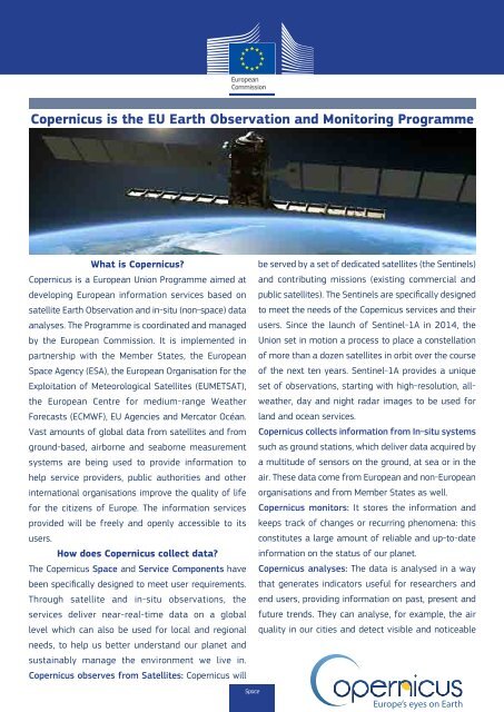
Copernicus is the EU Earth Observation and Monitoring Programme<br />
What is Copernicus?<br />
be served by a set of dedicated satellites (the <strong>Sentinel</strong>s)<br />
Copernicus is a European Union Programme aimed at and contributing missions (existing commercial and<br />
developing European information services based on public satellites). The <strong>Sentinel</strong>s are specifically designed<br />
satellite Earth Observation and in-situ (non-space) data to meet the needs of the Copernicus services and their<br />
analyses. The Programme is coordinated and managed users. Since the launch of <strong>Sentinel</strong>-1A in 2014, the<br />
by the European Commission. It is implemented in Union set in motion a process to place a constellation<br />
partnership with the Member States, the European of more than a dozen satellites in orbit over the course<br />
Space Agency (ESA), the European Organisation for the of the next ten years. <strong>Sentinel</strong>-1A provides a unique<br />
Exploitation of Meteorological Satellites (EUMETSAT), set of observations, starting with high-resolution, allweather,<br />
day and night radar images to be used for<br />
the European Centre for medium-range Weather<br />
Forecasts (ECMWF), EU Agencies and Mercator Océan. land and ocean services.<br />
Vast amounts of global data from satellites and from Copernicus collects information from In-situ systems<br />
ground-based, airborne and seaborne measurement such as ground stations, which deliver data acquired by<br />
systems are being used to provide information to a multitude of sensors on the ground, at sea or in the<br />
help service providers, public authorities and other air. These data come from European and non-European<br />
international organisations improve the quality of life organisations and from Member States as well.<br />
for the citizens of Europe. The information services Copernicus monitors: It stores the information and<br />
provided will be freely and openly accessible to its keeps track of changes or recurring phenomena: this<br />
users.<br />
constitutes a large amount of reliable and up-to-date<br />
How does Copernicus collect data? information on the status of our planet.<br />
The Copernicus Space and Service Components have Copernicus analyses: The data is analysed in a way<br />
been specifically designed to meet user requirements. that generates indicators useful for researchers and<br />
Through satellite and in-situ observations, the end users, providing information on past, present and<br />
services deliver near-real-time data on a global future trends. They can analyse, for example, the air<br />
level which can also be used for local and regional quality in our cities and detect visible and noticeable<br />
needs, to help us better understand our planet and<br />
sustainably manage the environment we live in.<br />
Copernicus observes from Satellites: Copernicus will<br />
Space<br />
increases in air pollution (smoke, dust, smog) • High resolution images, and lower<br />
or analyse the rise in global sea levels. resolution overviews;<br />
• Regular and systematic review of data;<br />
What are the services? • Reduced reaction time to enable better<br />
The services address six thematic areas: response to man-made or natural disasters;<br />
An Atmosphere Monitoring Service • Global/Pan European Approach to Earth<br />
⇢ fully operational from July 2015; monitoring.<br />
A Marine Environment Monitoring Service The Copernicus data policy promotes the<br />
⇢ fully operational since May 2015; access, use and sharing of Copernicus<br />
A Land Monitoring Service<br />
information and data on a full, free and<br />
⇢ fully operational since January 2013; open basis.<br />
A Climate Change Service<br />
How does Copernicus help<br />
⇢ in ramp-up phase;<br />
the citizens of Europe?<br />
An Emergency Management Service Copernicus is the concrete realisation of<br />
⇢ fully operational since April 2012; the European idea of providing our citizens<br />
A Security Service<br />
with new public services on both a European<br />
⇢ in ramp-up phase.<br />
and global scale. By investing in Earth<br />
monitoring and observation systems and<br />
What happens to the data? networks, which monitor and forecast the<br />
The Copernicus system delivers data and state of the environment on land, sea and<br />
information to Copernicus users, supplied in the atmosphere, we are now better able<br />
on a long term and sustainable basis understand our planet, protect and sustain<br />
through a set of services. The EC funds our environment and feel more safe and<br />
companies and public entities which provide secure.<br />
these services. The information can be used Copernicus in Action (examples)<br />
by end users for a wide range of applications • The Marine Environment Monitoring Service<br />
in a variety of areas. These include urban provided data to the Italian authorities<br />
area management, sustainable development supporting oil spill scenario calculations<br />
and nature protection, regional and local during the parbuckling of Costa Concordia;<br />
planning, agriculture, forestry and fisheries, • During the terrible floods that hit central<br />
health, civil protection, infrastructure, Europe in 2013 the Emergency Management<br />
transport and mobility, as well as tourism. Service provided reference maps and flood<br />
delineation to the affected areas;<br />
What is the added-value • Copernicus also plays an important role<br />
of the Copernicus System? in creating business opportunities for small<br />
• Guarantee of service, providing global and medium-sized enterprises, which create<br />
spatial coverage;<br />
jobs and growth. It is estimated that the<br />
• Near-real time data provided to end users; programme could result in some 48,000<br />
• Enable integration of the data (space and direct and indirect jobs being created over<br />
in-situ) and analyses;<br />
the period 2015-2030.<br />
Web: http://copernicus.eu | Facebook: Copernicus EU | Twitter: @CopernicusEU<br />
Photo credits: <strong>Sentinel</strong> ©ESA/DLR; Land Istock ©Dariusz Paciorek; Marine ©IStockphoto.com/Mercator-Ocean; Atmosphere ©FDC; Emergency: Fire Istock ©negaprion; Eartquake Fotolia ©puckillustrations; Flood ©On-Air; Security ©French Navy; Climate change Fotolia ©z576; In-situ component ©IRD, 2011.