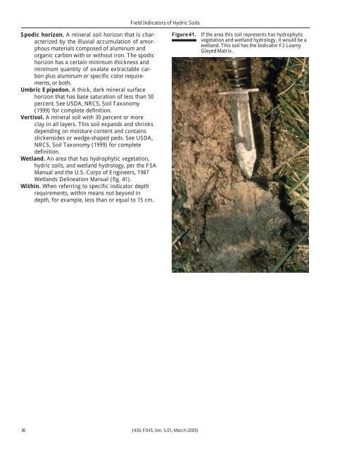
<strong>Field</strong> <strong>Indicators</strong> <strong>of</strong> <strong>Hydric</strong> <strong>Soils</strong>Spodic horizon. A m<strong>in</strong>eral soil horizon that is characterizedby <strong>the</strong> illuvial accumulation <strong>of</strong> amorphousmaterials composed <strong>of</strong> alum<strong>in</strong>um andorganic carbon with or without iron. The spodichorizon has a certa<strong>in</strong> m<strong>in</strong>imum thickness andm<strong>in</strong>imum quantity <strong>of</strong> oxalate extractable carbonplus alum<strong>in</strong>um or specific color requirements,or both.Umbric Epipedon. A thick, dark m<strong>in</strong>eral surfacehorizon that has base saturation <strong>of</strong> less than 50percent. See USDA, NRCS, Soil Taxonomy(1999) for complete def<strong>in</strong>ition.Vertisol. A m<strong>in</strong>eral soil with 30 percent or moreclay <strong>in</strong> all layers. This soil expands and shr<strong>in</strong>ksdepend<strong>in</strong>g on moisture content and conta<strong>in</strong>sslickensides or wedge-shaped peds. See USDA,NRCS, Soil Taxonomy (1999) for completedef<strong>in</strong>ition.Wetland. An area that has hydrophytic vegetation,hydric soils, and wetland hydrology, per <strong>the</strong> FSAManual and <strong>the</strong> U.S. Corps <strong>of</strong> Eng<strong>in</strong>eers, 1987Wetlands Del<strong>in</strong>eation Manual (fig. 41).With<strong>in</strong>. When referr<strong>in</strong>g to specific <strong>in</strong>dicator depthrequirements, with<strong>in</strong> means not beyond <strong>in</strong>depth, for example, less than or equal to 15 cm.Figure 41. If <strong>the</strong> area this soil represents has hydrophyticvegetation and wetland hydrology, it would be awetland. This soil has <strong>the</strong> Indicator F2 LoamyGleyed Matrix.30 (430, FIHS, Ver. 5.01, March 2003)
<strong>Field</strong> <strong>Indicators</strong> <strong>of</strong> <strong>Hydric</strong> <strong>Soils</strong>Appendix A<strong>Indicators</strong> by Land Resource Region (LRR)LRR<strong>Indicators</strong>AA1, A2, A3, A4, A10, S1, S4, S5, S6, F1 (except MLRA 1), F2, F3, F4, F5, F6, F7, F8, TF2, TF7.BCDEFGHIJKLMNOPRSA1, A2, A3, A4, A10, S1, S4, S5, S6, F1, F2, F3, F4, F5, F6, F7, F8, TF2, TF7.A1, A2, A3, A4, A10, S1, S4, S5, S6, F1, F2, F3, F4, F5, F6, F7, F8, F9, TF2, TF7.A1, A2, A3, A4, A9, S1, S4, S5, S6, F1, F2, F3, F4, F5, F6, F7, F8, F9, TA1, TF2, TF5, TF7, TF8.A1, A2, A3, A4, A10, S1, S4, S5, S6, F1, F2, F3, F4, F5, F6, F7, F8, TF2, TF7.A1, A2, A3, A4, A5, A9, S1, S3, S4, S5, S6, F1, F2, F3, F4, F5, F6, F7, F8, TS2, TS5, TF1, TF2, TF4, TF5,TF6, TF7.A1, A2, A3, A4, A9, S1, S2, S4, S5, S6, F1, F2, F3, F4, F5, F6, F7, F8, TS3, TS5, TF1, TF2, TF6, TF7.A1, A2, A3, A4, A9, S1, S2, S4, S5, S6, F1, F2, F3, F4, F5, F6, F7, F8, F16 (MLRAs 72 & 73 only), TS5,TF1, TF2, TF7.A1, A2, A3, A4, A9, S1, S4, S5, S6, F1, F2, F3, F4, F5, F6, F7, F8, TF2, TF7.A1, A2, A3, A4, A9, S1, S4, S5, S6, F1, F2, F3, F4, F5, F6, F7, F8, TF2, TF7.A1, A2, A3, A4, A5, A10, S1, S4, S5, S6, F1, F2, F3, F4, F5, F6, F7, F8, TS5, TF2, TF7.A1, A2, A3, A4, A5, A10, S1, S4, S5, S6, F1, F2, F3, F4, F5, F6, F7, F8, TS5, TF2, TF7.A1, A2, A3, A4, A5, A10, S1, S3, S4, S5, S6, F1, F2, F3, F4, F5, F6, F7, F8, F12, TS4, TS5, TF1, TF2, TF4, TF5,TF6, TF7, TF10.A1, A2, A3, A4, A5, A10, S1, S4, S5, S6, S7, F2, F3, F4, F5, F6, F7, F8, F12, TF2, TF7, TF10.A1, A2, A3, A4, A5, A9, S1, S4, S5, S6, F1, F2, F3, F4, F5, F6, F7, F8, F12, TF2, TF9.A1, A2, A3, A4, A5, A6, A7, A9, S4, S5, S6, S7, F2, F3, F4, F5, F6, F7, F8, F12, F13, TF2.A1, A2, A3, A4, A5, S1, S3, S4, S5, S6, S7, S8, S9, F2, F3, F4, F5, F6, F7, F8, TA2, TF2, TF7.A1, A2, A3, A4, A5, A10, S1, S4, S5, S6, S7, S8, S9, F2, F3, F4, F5, F6, F7, F8, TF2, TF4, TF10.T A1, A2, A3, A4, A5, A6, A7, A9, S4, S5, S6, S7, S8, S9, F2, F3, F4, F5, F6, F7, F8, F 11 (MLRA 151 Only), F12,F13, TA3 (MLRA 150a 0nly)U A1, A2, A3, A4, A5, A6, A7, A8, S4, S5, S6, S7, F2, F3, F4, F5, F6, F7, F10, F13.VWXYZA1, A2, A3, A4, A5, A8, S4, S5, S6, S7, F2, F3, F4, F5, F6, F7, F8, TF2, TF7.A1, A2, A3, A4, A10, S10, F4, F5, F6, F7, F8, F14, F15, TS1, TF2, TF3, TF7.A1, A2, A3, A4, A10, S10, F4, F5, F6, F7, F8, F14, F15, TS1, TF2, TF3, TF7.A1, A2, A3, A4, A10, S10, F4, F5, F6, F7, F8, F14, F15, TS1, TF2, TF3, TF7.A1, A2, A3, A4, A5, A6, A7, A8, S4, S5, S6, S7, F2, F3, F4, F5, F6, F7, F8, TF2, TF7.(430, FIHS, Ver. 5.01, March 2003) 31