Field Indicators of Hydric Soils in the United States - ITC
Field Indicators of Hydric Soils in the United States - ITC
Field Indicators of Hydric Soils in the United States - ITC
You also want an ePaper? Increase the reach of your titles
YUMPU automatically turns print PDFs into web optimized ePapers that Google loves.
<strong>Field</strong> <strong>Indicators</strong> <strong>of</strong> <strong>Hydric</strong> <strong>Soils</strong>ContentsForeword ........................................................................................ iLocation <strong>of</strong> <strong>Indicators</strong> by page ................................................... ivIntroduction ....................................................................................1Concept ...........................................................................................1Cautions ..........................................................................................3Procedure .......................................................................................3To Comment on <strong>the</strong> <strong>Indicators</strong> .....................................................4<strong>Field</strong> <strong>Indicators</strong> <strong>of</strong> <strong>Hydric</strong> <strong>Soils</strong> .............................................5All soils ...................................................................................5Sandy soils .............................................................................9Loamy and clayey soils ......................................................13Test <strong>Indicators</strong> <strong>of</strong> <strong>Hydric</strong> <strong>Soils</strong> .............................................20All soils .................................................................................20Sandy soils .......................................................................... 21Loamy and clayey soils ..................................................... 21References ....................................................................................24Glossary ........................................................................................25AppendixesAppendix A: <strong>Indicators</strong> by Land Resource Region ................31Appendix B: Indicator Correlations ....................................... 32(430, FIHS, Ver. 5.01, March 2003) iii
<strong>Field</strong> <strong>Indicators</strong> <strong>of</strong> <strong>Hydric</strong> <strong>Soils</strong>Location <strong>of</strong> <strong>Indicators</strong> by pageAll soilsA1 Histosol ...................................................... 5A2 Histic Epipedon ........................................ 5A3 Black Histic ...............................................5A4 Hydrogen Sulfide ......................................6A5 Stratified Layers ....................................... 6A6 Organic Bodies. ........................................ 7A7 5 cm Mucky M<strong>in</strong>eral .................................8A8 Muck Presence. ........................................ 8A9 1 cm Muck .................................................9A10 2 cm Muck .................................................9TA1 Playa Rim Stratified Layers ................... 20TA2 Structureless Muck ................................ 20TA3 Coast Prairie Redox ............................... 20Sandy soilsS1 Sandy Mucky M<strong>in</strong>eral .............................. 9S2 2.5 cm Mucky Peat or Peat ......................9S3 5 cm Mucky Peat or Peat ....................... 10S4 Sandy Gleyed Matrix .............................. 10S5 Sandy Redox ........................................... 10S6 Stripped Matrix ....................................... 10S7 Dark Surface ........................................... 12S8 Polyvalue Below Surface ....................... 12S9 Th<strong>in</strong> Dark Surface .................................. 13S10 Alaska Gleyed ......................................... 13TS1 Iron Sta<strong>in</strong><strong>in</strong>g ............................................ 21TS2 Thick Sandy Dark Surface ..................... 21TS3 Dark Surface 2 ........................................ 21TS4 Sandy Neutral Surface ........................... 21TS5 Chroma 3 Sandy Redox ......................... 21Loamy and clayey soilsF1 Loamy Mucky M<strong>in</strong>eral ........................... 13F2 Loamy Gleyed Matrix ............................. 14F3 Depleted Matrix ...................................... 14F4 Depleted Below Dark Surface ............... 15F5 Thick Dark Surface ................................ 15F6 Redox Dark Surface ............................... 16F7 Depleted Dark Surface ........................... 17F8 Redox Depressions ................................ 17F9 Vernal Pools ............................................ 17F10 Marl .......................................................... 18F11 Depleted Ochric ...................................... 18F12 Iron/Manganese Masses ......................... 18F13 Umbric Surface ....................................... 19F14 Alaska Redox Gleyed ............................. 19F15 Alaska Gleyed Pores .............................. 19F16 High Pla<strong>in</strong>s Depressions ........................ 20TF1 ? cm Mucky Peat or Peat ....................... 21TF2 Red Parent Material ............................... 21TF3 Alaska Concretions ................................ 22TF4 2.5Y/5Y Below Dark Surface ................. 22TF5 2.5Y/5Y Below Thick Dark Surface ...... 22TF6 Calcic Dark Surface ............................... 22TF7 Thick Dark Surface 2/1 .......................... 22TF8 Redox Spr<strong>in</strong>g Seeps. .............................. 23TF9 Delta Ochric ............................................ 23TF10 Alluvial Depleted Matrix ........................ 23TF11 Reduced Vertic ........................................ 23iv (430, FIHS, Ver. 5.01, March 2003)
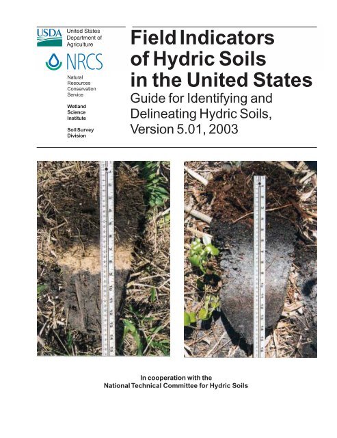
<strong>Field</strong> <strong>Indicators</strong> <strong>of</strong> <strong>Hydric</strong> <strong>Soils</strong> <strong>in</strong><strong>the</strong> <strong>United</strong> <strong>States</strong>Introduction<strong>Field</strong> <strong>Indicators</strong> <strong>of</strong> <strong>Hydric</strong> <strong>Soils</strong> <strong>in</strong> <strong>the</strong> <strong>United</strong><strong>States</strong> (hereafter referred to as <strong>Indicators</strong>) is a guideto help identify and del<strong>in</strong>eate hydric soils <strong>in</strong> <strong>the</strong> field(fig. 1). <strong>Indicators</strong> are not <strong>in</strong>tended to replace orrelieve <strong>the</strong> requirements conta<strong>in</strong>ed <strong>in</strong> <strong>the</strong> def<strong>in</strong>ition<strong>of</strong> a hydric soil. The list <strong>of</strong> <strong>Indicators</strong> is considered tobe dynamic; changes and additions are anticipatedannually. The section To Comment on <strong>the</strong> <strong>Indicators</strong>provides guidance to recommend changes, deletions,and additions. Any modifications to <strong>the</strong> <strong>Indicators</strong>must be approved by NRCS and <strong>the</strong> National TechnicalCommittee for <strong>Hydric</strong> <strong>Soils</strong>. To properly use <strong>the</strong><strong>Indicators</strong>, a basic knowledge <strong>of</strong> soil landscaperelationships and soil survey procedures is necessary.The <strong>in</strong>dicators are designed to be regionally specific.Each <strong>in</strong>dicator provides <strong>the</strong> Land Resource Regions(LRRs) or <strong>the</strong> Major Land Resource Areas (MLRAs)<strong>in</strong> which it can be used. The geographic extent <strong>of</strong>LRRs (fig. 2) and MLRAs are def<strong>in</strong>ed <strong>in</strong> USDA AgricultureHandbook 296 (USDA, SCS, 1981). LRR specific<strong>Indicators</strong> are listed <strong>in</strong> appendix A and described<strong>in</strong> section <strong>Field</strong> <strong>Indicators</strong> <strong>of</strong> <strong>Hydric</strong> <strong>Soils</strong>.The <strong>in</strong>dicators are used to identify <strong>the</strong> hydric soilcomponent <strong>of</strong> wetlands; however, some hydric soilsdo not have any <strong>of</strong> <strong>the</strong> currently listed <strong>in</strong>dicators.Therefore, <strong>the</strong> absence <strong>of</strong> any listed <strong>in</strong>dicator doesnot exclude <strong>the</strong> soil from be<strong>in</strong>g classed as hydric.Such soils should be studied and <strong>the</strong>ir characteristicmorphologies identified for <strong>in</strong>clusion <strong>in</strong> this guide.days. Saturation or <strong>in</strong>undation when comb<strong>in</strong>ed withmicrobial activity <strong>in</strong> <strong>the</strong> soil causes a depletion <strong>of</strong>oxygen. This anaerobiosis promotes biogeochemicalprocesses, such as <strong>the</strong> accumulation <strong>of</strong> organicmatter and <strong>the</strong> reduction, translocation, and/oraccumulation <strong>of</strong> iron and o<strong>the</strong>r reducible elements.These processes result <strong>in</strong> characteristic morphologiesthat persist <strong>in</strong> <strong>the</strong> soil dur<strong>in</strong>g both wet and dryperiods, mak<strong>in</strong>g <strong>the</strong>m particularly useful for identify<strong>in</strong>ghydric soils.Figure 1.The field <strong>in</strong>dicators are to be used to del<strong>in</strong>eatehydric soils. The soil on <strong>the</strong> right is hydric thathas <strong>the</strong> Indicator S6 Stripped Matrix start<strong>in</strong>g ata depth <strong>of</strong> about 14 cm, and <strong>the</strong> soil on <strong>the</strong> leftis nonhydric with <strong>the</strong> Stripped Matrix start<strong>in</strong>g ata depth <strong>of</strong> about 18 cm.Concept<strong>Hydric</strong> soils are def<strong>in</strong>ed as soils that formed underconditions <strong>of</strong> saturation, flood<strong>in</strong>g, or pond<strong>in</strong>g longenough dur<strong>in</strong>g <strong>the</strong> grow<strong>in</strong>g season to develop anaerobicconditions <strong>in</strong> <strong>the</strong> upper part <strong>of</strong> <strong>the</strong> soil (FederalRegister, July 13, 1994).Nearly all hydric soils exhibit characteristic morphologiesthat result from repeated periods <strong>of</strong> saturationor <strong>in</strong>undation, or both, for more than a few(430, FIHS, Ver. 5.01, March 2003) 1
CautionsSome hydric soils have morphologies that are difficultto <strong>in</strong>terpret or seem <strong>in</strong>consistent with <strong>the</strong> landscape,vegetation, or hydrology. Such soils <strong>in</strong>cludethose formed <strong>in</strong> grayish or reddish parent materials;soils that have high pH or low organic matter content;Mollisols and Vertisols; soils that have relictredoximorphic features; and disturbed soils, such ascultivated soils and filled areas.<strong>Field</strong> <strong>Indicators</strong> <strong>of</strong> <strong>Hydric</strong> <strong>Soils</strong><strong>of</strong>ten conta<strong>in</strong> no visible redoximorphic features. Inmany sites mak<strong>in</strong>g exploratory observations to ameter or more is necessary. These observationsshould be made with <strong>the</strong> <strong>in</strong>tent <strong>of</strong> document<strong>in</strong>g andunderstand<strong>in</strong>g <strong>the</strong> variability <strong>in</strong> soil properties andhydrologic relationships on <strong>the</strong> site.Depths used <strong>in</strong> <strong>the</strong> <strong>Indicators</strong> are measured from <strong>the</strong>muck or m<strong>in</strong>eral soil surface unless o<strong>the</strong>rwise <strong>in</strong>dicated.All colors refer to moist Munsell colors (fig. 3).Soil that is artificially dra<strong>in</strong>ed or protected, for <strong>in</strong>stance,by levees, is hydric if <strong>the</strong> soil <strong>in</strong> its undisturbedstate would meet <strong>the</strong> def<strong>in</strong>ition <strong>of</strong> a hydric soil. This soilshould also have at least one <strong>of</strong> <strong>the</strong> <strong>Indicators</strong>.Morphological features <strong>of</strong> hydric soils <strong>in</strong>dicate thatsaturation and anaerobic conditions have existedunder ei<strong>the</strong>r contemporary or former (recent) hydrologicregimes. Features that do not reflect contemporaryor recent hydrologic conditions <strong>of</strong> saturation andanaerobiosis are relict features. Typically, contemporaryand recent hydric soil morphologies have diffuseboundaries; relict hydric soil features have sharpboundaries. When soil morphology seems <strong>in</strong>consistentwith <strong>the</strong> landscape, vegetation, or observable hydrology,<strong>the</strong> assistance <strong>of</strong> an experienced soil or wetlandscientist may be needed to determ<strong>in</strong>e whe<strong>the</strong>r <strong>the</strong> soilis hydric.Soil colors specified <strong>in</strong> <strong>the</strong> <strong>Indicators</strong> do not havedecimal po<strong>in</strong>ts listed; however, colors do occur betweenMunsell chips. Soil colors should not berounded to qualify as meet<strong>in</strong>g an <strong>in</strong>dicator. For example,a soil matrix that has a chroma between 2 and3 should be listed as hav<strong>in</strong>g a chroma <strong>of</strong> 2+. This soilmaterial does not have a chroma 2 and would notmeet any <strong>in</strong>dicator that requires a chroma 2 or less.Particular attention should be paid to changes <strong>in</strong>topography over short distances (microtopography).Small changes <strong>in</strong> elevation may result <strong>in</strong> repetitivesequences <strong>of</strong> hydric/nonhydric soils. The del<strong>in</strong>eation<strong>of</strong> <strong>in</strong>dividual areas <strong>of</strong> hydric and nonhydric soils maybe difficult.Often <strong>the</strong> dom<strong>in</strong>ant condition (hydric/nonhydric) is<strong>the</strong> only reliable <strong>in</strong>terpretation. The shape <strong>of</strong> <strong>the</strong>local landform can greatly affect <strong>the</strong> movement <strong>of</strong>ProcedureTo document a hydric soil, first remove all loose leafmatter, needles, bark, and o<strong>the</strong>r easily identifiedplant parts to expose <strong>the</strong> surface. Dig a hole anddescribe <strong>the</strong> soil pr<strong>of</strong>ile to a depth <strong>of</strong> at least 50 cm(20 <strong>in</strong>). Us<strong>in</strong>g <strong>the</strong> completed soil description specifywhich <strong>Indicators</strong> have been matched.Deeper exam<strong>in</strong>ation <strong>of</strong> soil may be required wherefield <strong>in</strong>dicators are not easily seen with<strong>in</strong> 50 cm(20 <strong>in</strong>) <strong>of</strong> <strong>the</strong> surface. It is always recommended thatsoils be excavated and described as deep as necessaryto make reliable <strong>in</strong>terpretations. For example,exam<strong>in</strong>ation to less than 50 cm (20 <strong>in</strong>) may suffice <strong>in</strong>soils that have a surface horizon <strong>of</strong> organic materialor mucky m<strong>in</strong>eral material because <strong>the</strong>se shalloworganic accumulations only occur <strong>in</strong> hydric soils.Conversely, depth <strong>of</strong> excavation is <strong>of</strong>ten greater than50 cm (20 <strong>in</strong>) <strong>in</strong> Mollisols because <strong>the</strong> upper horizons<strong>of</strong> <strong>the</strong>se soils mask <strong>the</strong> effect <strong>of</strong> organic material andFigure 3.Indicator F6 Redox Dark Surface. The left ismoist and <strong>the</strong> right is dry. Most commonlymoist soil colors are to be used when identify<strong>in</strong>gand del<strong>in</strong>eat<strong>in</strong>g hydric soils.(430, FIHS, Ver. 5.01, March 2003) 3
<strong>Field</strong> <strong>Indicators</strong> <strong>of</strong> <strong>Hydric</strong> <strong>Soils</strong>water through <strong>the</strong> landscape. Significant changes <strong>in</strong>parent material or lithologic discont<strong>in</strong>uities <strong>in</strong> <strong>the</strong>soil can affect <strong>the</strong> hydrologic properties <strong>of</strong> <strong>the</strong> soil.After exploratory observations have been madesufficient to understand <strong>the</strong> soil-hydrologic relationshipsat <strong>the</strong> site, subsequent excavations may <strong>the</strong>nbe shallower if identification <strong>of</strong> appropriate <strong>in</strong>dicatorsallows.To Comment on <strong>the</strong> <strong>Indicators</strong>The <strong>Indicators</strong> are revised and updated as field dataare collected to improve our understand<strong>in</strong>g <strong>of</strong> hydricsoil processes (fig. 4). Revisions, additions, and o<strong>the</strong>rcomments regard<strong>in</strong>g field observations <strong>of</strong> hydric soilconditions that cannot be documented us<strong>in</strong>g <strong>the</strong>presently recognized <strong>Indicators</strong> are welcome; however,any modifications and additions must be approvedby NRCS and NTCHS. Guidel<strong>in</strong>es for request<strong>in</strong>gchanges to field <strong>in</strong>dicators are as follows:1. Add<strong>in</strong>g <strong>in</strong>dicators or chang<strong>in</strong>g exist<strong>in</strong>g <strong>in</strong>dicators—M<strong>in</strong>imally,<strong>the</strong> follow<strong>in</strong>g should accompanyall requests for additions and changes to exist<strong>in</strong>ghydric soil <strong>in</strong>dicators <strong>in</strong> <strong>Field</strong> <strong>Indicators</strong> <strong>of</strong> <strong>Hydric</strong><strong>Soils</strong> <strong>in</strong> <strong>the</strong> <strong>United</strong> <strong>States</strong>:(a) Detailed pedon descriptions <strong>of</strong> at least threepedons that document <strong>the</strong> addition or changeand detailed pedon descriptions <strong>of</strong> threeneighbor<strong>in</strong>g nonhydric pedons.(b) Detailed vegetative data collected to represent<strong>the</strong> vegetation <strong>of</strong> <strong>the</strong> six pedons.(c) Saturation/<strong>in</strong>undation data and redox potential(Eh) data for a duration that captures <strong>the</strong>saturation cycle (dry-wet-dry) <strong>of</strong> at least one<strong>of</strong> <strong>the</strong> hydric pedons and one <strong>of</strong> <strong>the</strong> nonhydricpedons. Precipitation and <strong>in</strong> situ soil-water pHdata from <strong>the</strong> same sites should also be provided.Monitor<strong>in</strong>g <strong>in</strong>strumentation should be<strong>in</strong>stalled accord<strong>in</strong>g to <strong>the</strong> <strong>Hydric</strong> Soil TechnicalStandard <strong>in</strong> Technical Note 11 (http://soils.usda.gov/soil_use/hydric/hstn.htm).2. Add<strong>in</strong>g a test <strong>in</strong>dicator—M<strong>in</strong>imally, <strong>the</strong> follow<strong>in</strong>gshould accompany all requests for add<strong>in</strong>g atest <strong>in</strong>dicator to <strong>Field</strong> <strong>Indicators</strong> <strong>of</strong> <strong>Hydric</strong> <strong>Soils</strong><strong>in</strong> <strong>the</strong> <strong>United</strong> <strong>States</strong>:(a) Detailed pedon descriptions <strong>of</strong> at least threepedons that document <strong>the</strong> test <strong>in</strong>dicator anddetailed pedon descriptions <strong>of</strong> three neighbor<strong>in</strong>gnonhydric pedons.(b) Detailed vegetative data collected to represent<strong>the</strong> vegetation <strong>of</strong> <strong>the</strong> six pedons.Figure 4.Proper <strong>in</strong>stallation <strong>of</strong> <strong>the</strong> right k<strong>in</strong>ds <strong>of</strong>monitor<strong>in</strong>g devices is important to obta<strong>in</strong>approval <strong>of</strong> changes and additions to <strong>the</strong> hydricsoil <strong>in</strong>dicators.3. All requests <strong>in</strong>volv<strong>in</strong>g 1 and 2 above additionallyrequire a short written plan that(a) Identifies <strong>the</strong> problem,(b) Expla<strong>in</strong>s <strong>the</strong> rationale for <strong>the</strong> request, and(c) Provides <strong>the</strong> follow<strong>in</strong>g:– person responsible and po<strong>in</strong>t <strong>of</strong> contact(e–mail and mail addresses and phonenumber)– timel<strong>in</strong>e for support<strong>in</strong>g data and f<strong>in</strong>al reportto be delivered to NTCHS– timel<strong>in</strong>e needed for f<strong>in</strong>al NTCHS decision– partners <strong>in</strong>volved <strong>in</strong> projectRequests and data should be sent to:Wade Hurt, ChairNTCHS <strong>Field</strong> Indicator SubcommitteeP.O. Box 110290University <strong>of</strong> FloridaGa<strong>in</strong>esville, FL 32611-0290e-mail: Wade_Hurt@mail.ifas.ufl.edu4 (430, FIHS, Ver. 5.01, March 2003)
<strong>Field</strong> <strong>Indicators</strong> <strong>of</strong> <strong>Hydric</strong> <strong>Soils</strong><strong>Field</strong> <strong>Indicators</strong> <strong>of</strong> <strong>Hydric</strong> <strong>Soils</strong> <strong>in</strong> <strong>the</strong> <strong>United</strong><strong>States</strong> is structured as follows:1. Alpha-numeric list<strong>in</strong>g2. Short name3. Applicable Land Resource Regions (LRRs)4. Description <strong>of</strong> <strong>the</strong> field <strong>in</strong>dicator5. User notesFor example, A1 <strong>in</strong>dicates <strong>the</strong> first <strong>in</strong>dicator for allsoils; Histosol or Histel is <strong>the</strong> short name; <strong>the</strong> <strong>in</strong>dicatoris for use <strong>in</strong> all LRRs; classifies as a Histosolexcept Folists is <strong>the</strong> field <strong>in</strong>dicator description; andhelpful user notes are added.All soilsAll soils refers to soils that have any USDA soiltexture. Unless o<strong>the</strong>rwise <strong>in</strong>dicated, all m<strong>in</strong>erallayers above any <strong>of</strong> <strong>the</strong> <strong>Indicators</strong> have dom<strong>in</strong>antchroma 2 or less, or <strong>the</strong> layer(s) with dom<strong>in</strong>antchroma <strong>of</strong> more than 2 is less than 15 cm (6 <strong>in</strong>) thick.Also, unless o<strong>the</strong>rwise <strong>in</strong>dicated, nodules and concretionsare not considered to be redox concentrations.Use <strong>the</strong> follow<strong>in</strong>g <strong>Indicators</strong> regardless <strong>of</strong> texture.Histic Epipedon User Notes: Most histic epipedonsare surface horizons 20 cm (8 <strong>in</strong>) or more thick <strong>of</strong>organic soil material. Aquic conditions or artificialdra<strong>in</strong>age are required. See Soil Taxonomy, (USDA,NRCS, Soil Survey Staff 1999). Slightly lower organiccarbon contents are allowed <strong>in</strong> plowed soils (ibid.).See glossary for def<strong>in</strong>itions. See figure 37 (organicsoil material) <strong>in</strong> <strong>the</strong> glossary for organic carbonrequirements.A3. Black Histic. For use <strong>in</strong> all LRRs except W, X,and Y; for test<strong>in</strong>g <strong>in</strong> LRRs W, X, and Y. A layer <strong>of</strong>peat, mucky peat, or muck 20 cm (8 <strong>in</strong>) or morethick start<strong>in</strong>g with<strong>in</strong> <strong>the</strong> upper 15 cm (6 <strong>in</strong>) <strong>of</strong><strong>the</strong> soil surface hav<strong>in</strong>g hue 10YR or yel-lower,value 3 or less, and chroma 1 or less (fig. 6).Black Histic User Notes: Unlike <strong>in</strong>dicator A2 this<strong>in</strong>dicator does not require pro<strong>of</strong> <strong>of</strong> aquic conditionsor artificial dra<strong>in</strong>age. See glossary for def<strong>in</strong>itions <strong>of</strong>peat, mucky peat, and muck. See figure 37 (organicsoil material) <strong>in</strong> <strong>the</strong> glossary for organic carbonrequirements.A1. Histosol (for use <strong>in</strong> all LRRs) or Histel (foruse <strong>in</strong> LRRs with permafrost). Classifies as aHistosol (except Folist) or as a Histel (exceptFolistel).Histosol User Notes: A Histosol has 40 cm (16 <strong>in</strong>)or more <strong>of</strong> <strong>the</strong> upper 80 cm (32 <strong>in</strong>) as organic soilmaterial (fig. 5). Organic soil material has an organiccarbon content (by weight) <strong>of</strong> 12 to 18 percent ormore, depend<strong>in</strong>g on <strong>the</strong> clay content <strong>of</strong> <strong>the</strong> soil. Thematerial <strong>in</strong>cludes muck (sapric soil material), muckypeat (hemic soil material), or peat (fibric soil material).See glossary for def<strong>in</strong>ition <strong>of</strong> muck, muckypeat, peat, and organic soil material. See figure 37(organic soil material) <strong>in</strong> <strong>the</strong> glossary for organiccarbon requirements. Histels are similar to Histosolsexcept <strong>the</strong>y are underla<strong>in</strong> by permafrost.A2. Histic Epipedon. For use <strong>in</strong> all LRRs except W,X, and Y; for test<strong>in</strong>g <strong>in</strong> LRRs W, X, and Y. A histicepipedon.Figure 5.Indicator A1 Histosols. Muck (sapric soilmaterial) is more than 80 cm thick. Scale isfeet (R) and m (L).(430, FIHS, Ver. 5.01, March 2003) 5
<strong>Field</strong> <strong>Indicators</strong> <strong>of</strong> <strong>Hydric</strong> <strong>Soils</strong>Figure 6.Indicator A3 Black Histic. Pro<strong>of</strong> <strong>of</strong> aquicconditions is not required. Scale is <strong>in</strong>ches (R)and cm (L).observed. Individual strata are dom<strong>in</strong>antly less than2.5 cm (1 <strong>in</strong>) thick. A hand lens is an excellent tool toaid <strong>in</strong> <strong>the</strong> identification <strong>of</strong> this <strong>in</strong>dicator. Many alluvialsoils have stratified layers at greater depths;<strong>the</strong>se are not hydric soils. Many alluvial soils havestratified layers at <strong>the</strong> required depths, but lackchroma 2 or less; <strong>the</strong>se do not fit this <strong>in</strong>dicator.Stratified layers occur <strong>in</strong> any type soil material (figs.7 and 8).Figure 7.Indicator A5 Stratified Layers is sandy. Scale is<strong>in</strong>ches.A4. Hydrogen Sulfide. For use <strong>in</strong> all LRRs. Ahydrogen sulfide odor with<strong>in</strong> 30 cm (12 <strong>in</strong>) <strong>of</strong><strong>the</strong> soil surface.Hydrogen Sulfide User Notes: The rotten egg smell<strong>in</strong>dicates that sulfate-sulfur has been reduced, and<strong>the</strong>refore <strong>the</strong> soil is anaerobic. In most hydric soils<strong>the</strong> sulfidic odor is only present when <strong>the</strong> soil issaturated and anaerobic.A5. Stratified Layers. For use <strong>in</strong> LRRs F, K, L, M,N, O, P, R, S, T, and U; for test<strong>in</strong>g <strong>in</strong> LRRs V and Z.Several stratified layers start<strong>in</strong>g with<strong>in</strong> <strong>the</strong>upper 15 cm (6 <strong>in</strong>) <strong>of</strong> <strong>the</strong> soil surface. One ormore <strong>of</strong> <strong>the</strong> layers has value 3 or less withchroma 1 or less, and/or it is muck, mucky peat,peat, or mucky modified m<strong>in</strong>eral texture. Therema<strong>in</strong><strong>in</strong>g layers have value 4 or more andchroma 2 or less.Stratified Layers User Notes: Use <strong>of</strong> this <strong>in</strong>dicatormay require assistance from a tra<strong>in</strong>ed soil scientistthat has local experience. The m<strong>in</strong>imum organiccarbon content <strong>of</strong> at least one layer <strong>of</strong> this <strong>in</strong>dicatoris slightly less than required for Indicator A7 MuckyModified M<strong>in</strong>eral Texture: at least 70 percent <strong>of</strong> soilmaterial is covered, coated, or similarly masked withorganic matter. An undisturbed sample must beFigure 8.Indicator A5 <strong>in</strong> loamy material. Scale is <strong>in</strong>ches(R) and cm (L).6 (430, FIHS, Ver. 5.01, March 2003)
<strong>Field</strong> <strong>Indicators</strong> <strong>of</strong> <strong>Hydric</strong> <strong>Soils</strong>A7. 5 cm Mucky M<strong>in</strong>eral. For use <strong>in</strong> LRRs P, T, U,and Z. A mucky modified m<strong>in</strong>eral surface layer 5cm (2 <strong>in</strong>) or more thick start<strong>in</strong>g with<strong>in</strong> 15 cm (6<strong>in</strong>) <strong>of</strong> <strong>the</strong> soil surface (fig. 12).5 cm Mucky M<strong>in</strong>eral User Notes: Mucky is a USDAtexture modifier for m<strong>in</strong>eral soil. The organic carboncontent is at least 5 percent and ranges to as high as18 percent. The percentage requirement is dependentupon <strong>the</strong> clay content <strong>of</strong> <strong>the</strong> soil; <strong>the</strong> higher <strong>the</strong>clay content, <strong>the</strong> higher <strong>the</strong> organic carbon requirement.An example is mucky f<strong>in</strong>e sand that has atleast 5 percent organic carbon, but not more thanabout 12 percent organic carbon. Ano<strong>the</strong>r example ismucky sandy loam that has at least 7 percent organiccarbon, but not more than about 14 percent organiccarbon. See <strong>the</strong> glossary for <strong>the</strong> def<strong>in</strong>ition <strong>of</strong> muckymodified m<strong>in</strong>eral texture. See figure 37 (organic soilmaterial) <strong>in</strong> <strong>the</strong> glossary for organic carbon requirements.A8. Muck Presence. For use <strong>in</strong> LRRs U, V, and Z. Alayer <strong>of</strong> muck that has a value 3 or less andchroma 1 or less with<strong>in</strong> 15 cm (6 <strong>in</strong>) <strong>of</strong> <strong>the</strong> soilsurface (fig. 13).Muck Presence User Notes: The presence <strong>of</strong> muck<strong>of</strong> any thickness with<strong>in</strong> 15 cm (6 <strong>in</strong>) is <strong>the</strong> only requirement.Normally this expression <strong>of</strong> anaerobiosisis at <strong>the</strong> soil surface; however, it may occur at anydepth with<strong>in</strong> 15 cm (6 <strong>in</strong>). Muck is sapric soil materialwith at least 12 to 18 percent organic carbon.Organic soil material is called muck (sapric soilmaterial) if virtually all <strong>of</strong> <strong>the</strong> material has undergonesufficient decomposition such that plant partscannot be identified. Hemic (mucky peat) and fibric(peat) soil materials do not qualify. To determ<strong>in</strong>e ifmuck is present, first remove loose leaves, needles,bark, and o<strong>the</strong>r easily identified plant rema<strong>in</strong>s. Thisis sometimes called a leaf/root mat. Then exam<strong>in</strong>efor decomposed organic soil material. Generally,muck is black and has a greasy feel; sand gra<strong>in</strong>sshould not be evident. <strong>Hydric</strong> soil <strong>in</strong>dicator determ<strong>in</strong>ationsare made below <strong>the</strong> leaf or root mat; however,root mats that meet <strong>the</strong> def<strong>in</strong>ition <strong>of</strong> hemic orfibric soil material are <strong>in</strong>cluded <strong>in</strong> <strong>the</strong> decisionmak<strong>in</strong>gprocess for Mucky Peat, Peat, Organic Bodies,or Histic <strong>Indicators</strong>. See <strong>the</strong> glossary for <strong>the</strong>def<strong>in</strong>ition <strong>of</strong> muck. See figure 37 (organic soil material)<strong>in</strong> <strong>the</strong> glossary for organic carbon requirements.Figure 12. Indicator A7 5 cm Mucky M<strong>in</strong>eral about 10 cmthick. Indicator S7 Dark Surface is alsopresent. Scale is <strong>in</strong>ches (R) and cm (L).Figure 13. <strong>Indicators</strong> A8 Muck Presence and S7 DarkSurface. Muck is less than 1 cm thick and <strong>the</strong>dark surface is 18 cm thick. Scale is <strong>in</strong>ches (R)and cm (L).8 (430, FIHS, Ver. 5.01, March 2003)
<strong>Field</strong> <strong>Indicators</strong> <strong>of</strong> <strong>Hydric</strong> <strong>Soils</strong>A9. 1 cm Muck. For use <strong>in</strong> LRRs D, F, G, H, P,and T; for test<strong>in</strong>g <strong>in</strong> LRRs I, J, and O. A layer <strong>of</strong>muck 1 cm (0.5 <strong>in</strong>) or more thick with value 3or less and chroma 1 or less start<strong>in</strong>g with<strong>in</strong> 15cm (6 <strong>in</strong>) <strong>of</strong> <strong>the</strong> soil surface.1 cm Muck User Notes: Unlike Indicator A8 MuckPresence, <strong>the</strong>re is a m<strong>in</strong>imum thickness requirement<strong>of</strong> 1 cm. Normally this expression <strong>of</strong> anaerobiosis isat <strong>the</strong> soil surface; however, it may occur at anydepth with<strong>in</strong> 15 cm (6 <strong>in</strong>). Muck is sapric soil materialwith at least 12 to 18 percent organic carbon.Organic soil material is called muck (sapric soilmaterial) if virtually all <strong>of</strong> <strong>the</strong> material has undergonesufficient decomposition to limit recognition <strong>of</strong><strong>the</strong> plant parts. Hemic (mucky peat) and fibric (peat)soil materials do not qualify. To determ<strong>in</strong>e if muck ispresent, first remove loose leaves, needles, bark, ando<strong>the</strong>r easily identified plant rema<strong>in</strong>s. This is sometimescalled a leaf/root mat. Then exam<strong>in</strong>e for decomposedorganic soil material. Generally, muck isblack and has a greasy feel; sand gra<strong>in</strong>s should not beevident. <strong>Hydric</strong> soil <strong>in</strong>dicator determ<strong>in</strong>ations aremade below <strong>the</strong> leaf or root mat; however, root matsthat meet <strong>the</strong> def<strong>in</strong>ition <strong>of</strong> hemic or fibric soil materialare <strong>in</strong>cluded <strong>in</strong> <strong>the</strong> decisionmak<strong>in</strong>g process forMucky Peat, Peat, Organic Bodies, or Histic <strong>Indicators</strong>.See <strong>the</strong> glossary for <strong>the</strong> def<strong>in</strong>ition <strong>of</strong> muck. Seefigure 37 (organic soil material) <strong>in</strong> <strong>the</strong> glossary fororganic carbon requirements.A10. 2 cm Muck. For use <strong>in</strong> LRRs M and N; fortest<strong>in</strong>g <strong>in</strong> LRRs A, B, C, E, K, L, S, W, X, Y, and Z. Alayer <strong>of</strong> muck 2 cm (0.75 <strong>in</strong>) or more thick withvalue 3 or less and chroma 1 or less start<strong>in</strong>gwith<strong>in</strong> 15 cm (6 <strong>in</strong>) <strong>of</strong> <strong>the</strong> soil surface.2 cm Muck User Notes: This Indicator requires am<strong>in</strong>imum muck thickness <strong>of</strong> 2 cm. Normally thisexpression <strong>of</strong> anaerobiosis is at <strong>the</strong> soil surface;however, it may occur at any depth with<strong>in</strong> 15 cm(6 <strong>in</strong>). Muck is sapric soil material with at least 12 to18 percent organic carbon. Organic soil material iscalled muck (sapric soil material) if virtually all <strong>of</strong><strong>the</strong> material has undergone sufficient decompositionto limit recognition <strong>of</strong> <strong>the</strong> plant parts. Hemic (muckypeat) and fibric (peat) soil materials do not qualify.To determ<strong>in</strong>e if muck is present, first remove looseleaves, needles, bark, and o<strong>the</strong>r easily identifiedplant rema<strong>in</strong>s. This is sometimes called a leaf/rootmat. Then exam<strong>in</strong>e for decomposed organic soilmaterial. Generally, muck is black and has a greasyfeel; sand gra<strong>in</strong>s should not be evident. <strong>Hydric</strong> soil<strong>in</strong>dicator determ<strong>in</strong>ations are made below <strong>the</strong> leaf orroot mat; however, root mats that meet <strong>the</strong> def<strong>in</strong>ition<strong>of</strong> hemic or fibric soil material are <strong>in</strong>cluded <strong>in</strong> <strong>the</strong>decisionmak<strong>in</strong>g process for Mucky Peat, Peat, OrganicBodies, or Histic <strong>Indicators</strong>. See <strong>the</strong> glossaryfor <strong>the</strong> def<strong>in</strong>ition <strong>of</strong> muck. See figure 37 (organic soilmaterial) <strong>in</strong> <strong>the</strong> glossary for organic carbon requirements.Sandy soilsSandy soils refers to those soils that have a USDAtexture <strong>of</strong> loamy f<strong>in</strong>e sand and coarser. Unless o<strong>the</strong>rwise<strong>in</strong>dicated, all m<strong>in</strong>eral layers above any <strong>of</strong> <strong>the</strong><strong>Indicators</strong> have dom<strong>in</strong>ant chroma 2 or less, or <strong>the</strong>layer(s) with dom<strong>in</strong>ant chroma <strong>of</strong> more than 2 is lessthan 15 cm (6 <strong>in</strong>) thick. In addition, unless o<strong>the</strong>rwise<strong>in</strong>dicated, nodules and concretions are not consideredto be redox concentrations. Use <strong>the</strong> follow<strong>in</strong>g sandy<strong>Indicators</strong> for sandy m<strong>in</strong>eral soil materials:S1. Sandy Mucky M<strong>in</strong>eral. For use <strong>in</strong> all LRRsexcept W, X, and Y. A mucky modified sandy m<strong>in</strong>erallayer 5 cm (2 <strong>in</strong>) or more thick start<strong>in</strong>gwith<strong>in</strong> 15 cm (6 <strong>in</strong>) <strong>of</strong> <strong>the</strong> soil surface.Sandy Mucky M<strong>in</strong>eral User Notes: Mucky is aUSDA texture modifier for m<strong>in</strong>eral soils. The organiccarbon content is at least 5 percent and ranges to ashigh as 14 percent for sandy soils. The percent-agerequirement is dependent upon <strong>the</strong> clay content <strong>of</strong><strong>the</strong> soil; <strong>the</strong> higher <strong>the</strong> clay content, <strong>the</strong> higher <strong>the</strong>organic carbon requirement. An example is muckyf<strong>in</strong>e sand that has at least 5 percent organic carbon,but not more than about 12 percent organic carbon.See <strong>the</strong> glossary for <strong>the</strong> def<strong>in</strong>ition <strong>of</strong> mucky modifiedm<strong>in</strong>eral texture. See figure 37 (organic soilmaterial) <strong>in</strong> <strong>the</strong> glossary for organic carbon requirements.S2. 2.5 cm Mucky Peat or Peat. For use <strong>in</strong> LRRs Gand H. A layer <strong>of</strong> mucky peat or peat 2.5 cm (1<strong>in</strong>) or more thick with value 4 or less andchroma 3 or less start<strong>in</strong>g with<strong>in</strong> 15 cm (6 <strong>in</strong>) <strong>of</strong><strong>the</strong> soil surface underla<strong>in</strong> by sandy soil material.2.5 cm Mucky Peat and Peat User Notes: Muckypeat (hemic soil material) and peat (fibric soil material)hav<strong>in</strong>g at least 12 to 18 percent organic carbon.Organic soil material is called peat if virtually all <strong>of</strong><strong>the</strong> plant rema<strong>in</strong>s are sufficiently <strong>in</strong>tact to permitidentification <strong>of</strong> plant rema<strong>in</strong>s. Mucky peat is an(430, FIHS, Ver. 5.01, March 2003) 9
<strong>Field</strong> <strong>Indicators</strong> <strong>of</strong> <strong>Hydric</strong> <strong>Soils</strong>Stripped Matrix User Notes: This <strong>in</strong>dicator <strong>in</strong>cludes<strong>the</strong> <strong>in</strong>dicator previously named polychromaticmatrix (Florida Soil Survey Staff, 1992) aswell as <strong>the</strong> term streak<strong>in</strong>g (Environmental Laboratory,1987) (app. B). Common to many (USDA, SoilSurvey Division Staff, 1993) areas <strong>of</strong> stripped (uncoated)soil materials 1 to 3 cm (0.5 to 1 <strong>in</strong>) <strong>in</strong> size isa requirement. Commonly <strong>the</strong> splotches <strong>of</strong> color havevalue 5 or more and chroma 1 and/or 2 (stripped) andchroma 3 and/or 4 (unstripped). The matrix may lack<strong>the</strong> 3 and/or 4 chroma material. The mobilization andtranslocation <strong>of</strong> <strong>the</strong> oxides and/or organic matter is<strong>the</strong> important process and should result <strong>in</strong> splotchycoated and uncoated soil areas (figs. 16, 17, and 18).Figure 16. Indicator S6 Stripped Matrix. The matrixstripped <strong>of</strong> iron oxides beg<strong>in</strong>s below a depth <strong>of</strong>about 10 cm. Scale is <strong>in</strong>ches (R) and cm (L).Figure 15. Indicator S5 Sandy Redox. The redox massesoccur below a depth <strong>of</strong> about 10 cm. Scale is<strong>in</strong>ches.Figure 17. Indicator S6 Stripped Matrix. The matrix stripped<strong>of</strong> organic matter beg<strong>in</strong>s beneath <strong>the</strong> surfacelayer. Scale is <strong>in</strong>ches.(430, FIHS, Ver. 5.01, March 2003) 11
<strong>Field</strong> <strong>Indicators</strong> <strong>of</strong> <strong>Hydric</strong> <strong>Soils</strong>S7. Dark Surface. For use <strong>in</strong> LRRs N, P, R, S, T, U,V, and Z. A layer 10 cm (4 <strong>in</strong>) or more thickstart<strong>in</strong>g with<strong>in</strong> <strong>the</strong> upper 15 cm (6 <strong>in</strong>) <strong>of</strong> <strong>the</strong> soilsurface with a matrix value 3 or less and chroma1 or less. At least 70 percent <strong>of</strong> <strong>the</strong> visiblesoil particles must be covered, coated, orsimilarly masked with organic material. Thematrix color <strong>of</strong> <strong>the</strong> layer immediately below<strong>the</strong> dark layer must have chroma 2 or less(fig. 19).Dark Surface User Notes: The organic carboncontent <strong>of</strong> this <strong>in</strong>dicator is slightly less than requiredfor mucky. An undisturbed sample must beobserved. A 10X or 15X hand lens is an excellent toolto aid this decision. Many wet soils have a ratio <strong>of</strong>about 50 percent soil particles that are coveredor coated with organic matter and about 50 percentuncoated or uncovered soil particles, giv<strong>in</strong>g <strong>the</strong> soil asalt and pepper appearance. Where <strong>the</strong> percent <strong>of</strong>coverage is less than 70 percent, a Dark Surface<strong>in</strong>dicator is not present.S8. Polyvalue Below Surface. For use <strong>in</strong> LRRs R,S, and T; for test<strong>in</strong>g <strong>in</strong> LRRs K and L. A layer withvalue 3 or less and chroma 1 or less start<strong>in</strong>gwith<strong>in</strong> 15 cm (6 <strong>in</strong>) <strong>of</strong> <strong>the</strong> soil surface underla<strong>in</strong>by a layer(s) where translocated organic matterunevenly covers <strong>the</strong> soil material form<strong>in</strong>g adiffuse splotchy pattern. At least 70 percent <strong>of</strong><strong>the</strong> visible soil particles <strong>in</strong> <strong>the</strong> upper layer mustbe covered, coated, or masked with organicmaterial. Immediately below this layer, <strong>the</strong> organiccoat<strong>in</strong>g occupies 5 percent or more <strong>of</strong> <strong>the</strong>soil volume and has value 3 or less and chroma 1or less. The rema<strong>in</strong>der <strong>of</strong> <strong>the</strong> soil volume hasvalue 4 or more and chroma 1 or less.Polyvalue Below Surface User Notes: This <strong>in</strong>dicatordescribes soils with a very dark gray or blacksurface or near-surface layer less than 10 cm (4 <strong>in</strong>)thick underla<strong>in</strong> by a layer where organic matter hasbeen differentially distributed with<strong>in</strong> <strong>the</strong> soil bywater movement (figs. 19 and 20). The mobilizationand translocation <strong>of</strong> organic matter results <strong>in</strong>splotchy coated and uncoated soil areas as described<strong>in</strong> <strong>the</strong> Sandy Redox and Stripped Matrix <strong>Indicators</strong>except that for S8 <strong>the</strong> whole soil is <strong>in</strong> shades <strong>of</strong> blackand gray. The chroma 1 or less is critical because itlimits application <strong>of</strong> this <strong>in</strong>dicator to only those soilsthat are depleted <strong>of</strong> iron. This <strong>in</strong>dicator <strong>in</strong>cludes <strong>the</strong><strong>in</strong>dicator previously termed streak<strong>in</strong>g (EnvironmentalLaboratory, 1987) (app. B).Figure 18. Indicator S6 Stripped Matrix. Close up <strong>of</strong> ovalstripped areas show<strong>in</strong>g <strong>the</strong> associated decompos<strong>in</strong>groots.Figure 19. Indicator S7 Dark Surface. The dark surface is15 cm thick. The material below 15 cm meets<strong>the</strong> <strong>in</strong>tent <strong>of</strong> Indicator S8 Polyvalue BelowSurface. Scale is <strong>in</strong>ches.12 (430, FIHS, Ver. 5.01, March 2003)
<strong>Field</strong> <strong>Indicators</strong> <strong>of</strong> <strong>Hydric</strong> <strong>Soils</strong>S9. Th<strong>in</strong> Dark Surface. For use <strong>in</strong> LRRs R, S, andT; for test<strong>in</strong>g <strong>in</strong> LRRs K and L. A layer 5 cm (2 <strong>in</strong>)or more thick entirely with<strong>in</strong> <strong>the</strong> upper 15 cm (6<strong>in</strong>) <strong>of</strong> <strong>the</strong> surface, with value 3 or less andchroma 1 or less. At least 70 percent <strong>of</strong> <strong>the</strong>visible soil particles <strong>in</strong> this layer must be covered,coated, or masked with organic material.This layer is underla<strong>in</strong> by a layer(s) with value 4or less and chroma 1 or less to a depth <strong>of</strong> 30 cm(12 <strong>in</strong>) or to <strong>the</strong> spodic horizon, whichever isless.Th<strong>in</strong> Dark Surface User Notes: This <strong>in</strong>dicatordescribes soils with a very dark gray or black nearsurfacelayer at least 5 cm (2 <strong>in</strong>) thick underla<strong>in</strong> by alayer where organic matter has been carried downwardby flow<strong>in</strong>g water (fig. 20). The mobilization andtranslocation <strong>of</strong> organic matter results <strong>in</strong> an unevendistribution <strong>of</strong> organic matter <strong>in</strong> <strong>the</strong> eluvial (E)Figure 20. Indicator S8 Polyvalue Below Surface (R) andIndicator S9 Th<strong>in</strong> Dark Surface (L). Organicmatter has been mobilized and translocated. Aspodic horizon is not required but commonlyoccurs <strong>in</strong> soils with <strong>the</strong>se <strong>in</strong>dicators. Scale is<strong>in</strong>ches.horizon. The chroma 1 or less is critical because itlimits application <strong>of</strong> this <strong>in</strong>dicator to only those soilsthat are depleted <strong>of</strong> iron. This <strong>in</strong>dicator commonlyoccurs <strong>in</strong> hydric Spodosols; however, a spodic horizonis not required.S10. Alaska Gleyed. For use <strong>in</strong> LRRs W, X, and Y.Dom<strong>in</strong>ant hue N, 10Y, 5GY, 10GY, 5G, 10G, 5BG,10BG, 5B, 10B, or 5PB, with value 4 or more <strong>in</strong><strong>the</strong> matrix, with<strong>in</strong> 30 cm (12 <strong>in</strong>) <strong>of</strong> <strong>the</strong> m<strong>in</strong>eralsurface, and underla<strong>in</strong> by hue 5Y or redder <strong>in</strong> <strong>the</strong>same type <strong>of</strong> parent material.Alaska Gleyed User Notes: Gley colors are notsynonymous with gray colors. Gley colors are thosecolors that are on <strong>the</strong> gley page (Gretag/Macbeth.2000). They have hue N, 10Y, 5GY, 10GY, 5G, 10G,5BG, 10BG, 5B, 10B, or 5PB, with value 4 or more.Color comparison to underly<strong>in</strong>g material must bebased on material <strong>of</strong> <strong>the</strong> same type or lithology.Loamy and clayey soilsLoamy and clayey soils refers to those soils withUSDA textures <strong>of</strong> loamy very f<strong>in</strong>e sand and f<strong>in</strong>er.Unless o<strong>the</strong>rwise <strong>in</strong>dicated, all m<strong>in</strong>eral layers aboveany <strong>of</strong> <strong>the</strong> <strong>Indicators</strong> have dom<strong>in</strong>ant chroma 2 orless, or <strong>the</strong> layer(s) with dom<strong>in</strong>ant chroma <strong>of</strong> morethan 2 is less than 15 cm (6 <strong>in</strong>) thick. Also, unlesso<strong>the</strong>rwise <strong>in</strong>dicated, nodules and concretions are notconsidered to be redox concentrations. Use <strong>the</strong>follow<strong>in</strong>g loamy and clayey <strong>Indicators</strong> for loamy orclayey m<strong>in</strong>eral soil materials:F1. Loamy Mucky M<strong>in</strong>eral. For use <strong>in</strong> all LRRsexcept N, R, S, V, W, X, and Y, those us<strong>in</strong>g A7, andMLRA 1 <strong>of</strong> LRR A. A mucky modified loamy orclayey m<strong>in</strong>eral layer 10 cm (4 <strong>in</strong>) or more thickstart<strong>in</strong>g with<strong>in</strong> 15 cm (6 <strong>in</strong>) <strong>of</strong> <strong>the</strong> soil surface.Loamy Mucky M<strong>in</strong>eral User Notes: Mucky is aUSDA texture modifier for m<strong>in</strong>eral soils. The organiccarbon is at least 8 percent, but can range to as highas 18 percent. The percentage requirement is dependentupon <strong>the</strong> clay content <strong>of</strong> <strong>the</strong> soil; <strong>the</strong> higher <strong>the</strong>clay content, <strong>the</strong> higher <strong>the</strong> organic carbon requirement.An example is mucky sandy loam that has atleast 8 percent organic carbon, but not more thanabout 14 percent organic carbon. See <strong>the</strong> glossary for<strong>the</strong> def<strong>in</strong>ition <strong>of</strong> mucky modified m<strong>in</strong>eral texture. Seefigure 37 (organic soil material) <strong>in</strong> <strong>the</strong> glossary fororganic carbon requirements.(430, FIHS, Ver. 5.01, March 2003) 13
<strong>Field</strong> <strong>Indicators</strong> <strong>of</strong> <strong>Hydric</strong> <strong>Soils</strong>F2. Loamy Gleyed Matrix. For use <strong>in</strong> all LRRsexcept W, X, and Y. A gleyed matrix that occupies60 percent or more <strong>of</strong> a layer start<strong>in</strong>g with<strong>in</strong> 30cm (12 <strong>in</strong>) <strong>of</strong> <strong>the</strong> soil surface.Loamy Gleyed Matrix User Notes: Gley colors arenot synonymous with gray colors. Gley colors arethose colors that are on <strong>the</strong> gley pages (Gretag/Macbeth. 2000). They have hue N, 10Y, 5GY, 10GY, 5G,10G, 5BG, 10BG, 5B, 10B, or 5PB, with value 4 ormore. The gleyed matrix only has to be presentwith<strong>in</strong> 30 cm (12 <strong>in</strong>) <strong>of</strong> <strong>the</strong> surface. <strong>Soils</strong> with gleyedmatrices are saturated for a significant duration; thisis why no thickness <strong>of</strong> <strong>the</strong> layer is required (figs. 21and 22). See glossary for <strong>the</strong> def<strong>in</strong>ition <strong>of</strong> gleyedmatrix.Figure 21. Indicator F2 Loamy Gleyed Matrix. The gleyedmatrix beg<strong>in</strong>s at a depth <strong>of</strong> about 18 cm.Indicator F3 Depleted Matrix also occursbetween <strong>the</strong> gleyed matrix and <strong>the</strong> surfacelayer.F3. Depleted Matrix. For use <strong>in</strong> all LRRs except W,X, and Y. A layer with a depleted matrix that has60 percent or more chroma 2 or less that has am<strong>in</strong>imum thickness <strong>of</strong> ei<strong>the</strong>r:a. 5 cm (2 <strong>in</strong>) if 5 cm (2 <strong>in</strong>) is entirelywith<strong>in</strong> <strong>the</strong> upper 15 cm (6 <strong>in</strong>) <strong>of</strong> <strong>the</strong> soil,orb. 15 cm (6 <strong>in</strong>) and starts with<strong>in</strong> 25 cm(10 <strong>in</strong>) <strong>of</strong> <strong>the</strong> soil surface.Depleted Matrix User Notes: Redox concentrations<strong>in</strong>clud<strong>in</strong>g iron/manganese s<strong>of</strong>t masses or pore l<strong>in</strong><strong>in</strong>gs,or both, are required <strong>in</strong> soils with matrix colors <strong>of</strong> 4/1,4/2, and 5/2 (fig. 23). A, E and calcic horizons mayhave low chromas and high values and may <strong>the</strong>reforebe mistaken for a depleted matrix; however, <strong>the</strong>y areexcluded from <strong>the</strong> concept <strong>of</strong> depleted matrix unlesscommon or many, dist<strong>in</strong>ct or prom<strong>in</strong>ent redox concentrationsas s<strong>of</strong>t masses or pore l<strong>in</strong><strong>in</strong>gs are present.Redox concentrations are not required for soils withmatrix value 5 or more and chroma 1 or value 6 ormore and chroma 2 or 1 (fig. 24). See glossary for <strong>the</strong>complete def<strong>in</strong>ition <strong>of</strong> depleted matrix. The lowchroma matrix must be caused by wetness and not arelict or parent material feature.Figure 22. Indicator F2 Loamy Gleyed Matrix. The gleyedmatrix starts at <strong>the</strong> soil surface. Scale is<strong>in</strong>ches.14 (430, FIHS, Ver. 5.01, March 2003)
<strong>Field</strong> <strong>Indicators</strong> <strong>of</strong> <strong>Hydric</strong> <strong>Soils</strong>F4. Depleted Below Dark Surface. For use <strong>in</strong> allLRRs except W, X, and Y; for test<strong>in</strong>g <strong>in</strong> LRRs W, X,and Y. A layer with a depleted matrix that has 60percent or more chroma 2 or less start<strong>in</strong>g with<strong>in</strong>30 cm (12 <strong>in</strong>) <strong>of</strong> <strong>the</strong> soil surface that has a m<strong>in</strong>imumthickness <strong>of</strong> ei<strong>the</strong>r:a. 15 cm (6 <strong>in</strong>),b. 5 cm (2 <strong>in</strong>) if <strong>the</strong> 5 cm (2 <strong>in</strong>) consists <strong>of</strong>fragmental soil material (see glossary).The layer(s) above <strong>the</strong> depleted matrix has value3 or less and chroma 2 or less.Depleted Below Dark Surface User Notes: This<strong>in</strong>dicator <strong>of</strong>ten occurs <strong>in</strong> Mollisols, but also applies tosoils that have umbric epipedons and dark coloredochric epipedons. For soils that have dark coloredepipedons greater than 30 cm (12 <strong>in</strong>) thick, useIndicator F5. Redox concentrations <strong>in</strong>clud<strong>in</strong>g iron/Figure 23. Indicator F3 Depleted Matrix. The chroma is 2below a depth <strong>of</strong> about 15 cm. Redox concentrationsare present. Scale is <strong>in</strong>ches.manganese s<strong>of</strong>t masses, pore l<strong>in</strong><strong>in</strong>gs, or both, arerequired <strong>in</strong> soils that have matrix colors <strong>of</strong> 4/1, 4/2,and 5/2. A, E, and calcic horizons may have lowchromas depleted matrix; however, <strong>the</strong>y are excludedfrom <strong>the</strong> concept <strong>of</strong> depleted matrix unlesscommon or many, dist<strong>in</strong>ct or prom<strong>in</strong>ent redox concentrationsas s<strong>of</strong>t masses or pore l<strong>in</strong><strong>in</strong>gs arepresent. See glossary for <strong>the</strong> def<strong>in</strong>ition <strong>of</strong> depletedmatrix.F5. Thick Dark Surface. For use <strong>in</strong> all LRRs exceptW, X, and, Y; for test<strong>in</strong>g <strong>in</strong> LRRs W, X, and Y. Alayer at least 15 cm (6 <strong>in</strong>) thick with a depletedmatrix that has 60 percent or more chroma 2 orless (or a gleyed matrix) start<strong>in</strong>g below 30 cm(12 <strong>in</strong>) <strong>of</strong> <strong>the</strong> surface. The layer(s) above <strong>the</strong>depleted or gleyed matrix has hue N and value 3or less to a depth <strong>of</strong> 30 cm (12 <strong>in</strong>) and value 3 orless and chroma 1 or less <strong>in</strong> <strong>the</strong> rema<strong>in</strong>der <strong>of</strong> <strong>the</strong>epipedon.Thick Dark Surface User Notes: The soil has ablack or very dark gray surface layer 30 cm (12 <strong>in</strong>)or more thick (figs. 25 and 26). The dark subsoil hasvalue 3 or less, and chroma 1 or less. Below <strong>the</strong> darkcolored epipedon is a depleted matrix or gleyedmatrix. This <strong>in</strong>dicator is most <strong>of</strong>ten associated withoverthickened soils <strong>in</strong> concave landscape positions.Figure 24. Indicator F3 Depleted Matrix. The chroma is 1with<strong>in</strong> a depth <strong>of</strong> about 10 to 15 cm. Redoxconcentrations are absent. Scale is <strong>in</strong>ches.(430, FIHS, Ver. 5.01, March 2003) 15
<strong>Field</strong> <strong>Indicators</strong> <strong>of</strong> <strong>Hydric</strong> <strong>Soils</strong>Figure 25. Indicator F5 Thick Dark Surface. A depletedmatrix is below <strong>the</strong> mollic epipedon. Scale is<strong>in</strong>ches.Redox concentrations <strong>in</strong>clud<strong>in</strong>g iron/manganese s<strong>of</strong>tmasses or pore l<strong>in</strong><strong>in</strong>gs, or both, are required <strong>in</strong> soilsthat have matrix colors <strong>of</strong> 4/1, 4/2, and 5/2. A, E, andcalcic horizons may have low chromas and highvalues and may be mistaken for a depleted matrix.They are excluded, however, from <strong>the</strong> concept <strong>of</strong>depleted matrix unless common or many, dist<strong>in</strong>ct orprom<strong>in</strong>ent redox concentrations as s<strong>of</strong>t masses orpore l<strong>in</strong><strong>in</strong>gs are present. See glossary for <strong>the</strong> def<strong>in</strong>ition<strong>of</strong> depleted matrix.F6. Redox Dark Surface. For use <strong>in</strong> all LRRsexcept W, X, and Y; for test<strong>in</strong>g <strong>in</strong> LRRs W, X, and Y.A layer at least 10 cm (4 <strong>in</strong>) thick entirelywith<strong>in</strong> <strong>the</strong> upper 30 cm (12 <strong>in</strong>) <strong>of</strong> <strong>the</strong> m<strong>in</strong>eralsoil that has:a. matrix value 3 or less and chroma 1 orless and 2 percent or more dist<strong>in</strong>ct orprom<strong>in</strong>ent redox concentrations as s<strong>of</strong>tmasses or pore l<strong>in</strong><strong>in</strong>gs, orb. matrix value 3 or less and chroma 2 orless and 5 percent or more dist<strong>in</strong>ct orprom<strong>in</strong>ent redox concentrations as s<strong>of</strong>tmasses or pore l<strong>in</strong><strong>in</strong>gs.Figure 26. Indicator F5 Thick Dark Surface. Deep observationis <strong>of</strong>ten necessary.Redox Dark Surface User Notes: Redox concentrations<strong>in</strong> high organic matter m<strong>in</strong>eral soils with a darksurface are <strong>of</strong>ten difficult to see (figs. 27 and 28).The organic matter masks some or all <strong>of</strong> <strong>the</strong> concentrationsthat may be present. Careful exam<strong>in</strong>ation isrequired to see what are <strong>of</strong>ten brownish mottles <strong>in</strong><strong>the</strong> darkened materials. In some <strong>in</strong>stances, dry<strong>in</strong>g <strong>of</strong><strong>the</strong> samples makes <strong>the</strong> concentrations (if present)easier to see. Dried colors, if used, need to havematrix chromas <strong>of</strong> 1 or 2, and <strong>the</strong> redox concentrationsneed to be dist<strong>in</strong>ct or prom<strong>in</strong>ent.In soils that are wet because <strong>of</strong> subsurface saturation,<strong>the</strong> layer immediately below <strong>the</strong> dark epipedonshould have a depleted or gleyed matrix. <strong>Soils</strong> thatare wet because <strong>of</strong> pond<strong>in</strong>g or shallow, perched layer<strong>of</strong> saturation may not always have a depleted/gleyedmatrix below <strong>the</strong> dark surface. This morphology hasbeen observed <strong>in</strong> soils that have been compacted bytillage and o<strong>the</strong>r means. It is recommended thatdel<strong>in</strong>eators evaluate <strong>the</strong> hydrologic source andexam<strong>in</strong>e and describe <strong>the</strong> layer below <strong>the</strong> darkcolored epipedon when apply<strong>in</strong>g this <strong>in</strong>dicator. Redoxconcentrations <strong>in</strong>clud<strong>in</strong>g iron/manganese s<strong>of</strong>tmasses or pore l<strong>in</strong><strong>in</strong>gs, or both, are required <strong>in</strong> soilsthat have matrix colors <strong>of</strong> 4/1, 4/2, and 5/2. A, E, andcalcic horizons may have low chromas and highvalues and may, <strong>the</strong>refore, be mistaken for a depletedmatrix; however, <strong>the</strong>y are excluded from <strong>the</strong>16 (430, FIHS, Ver. 5.01, March 2003)
<strong>Field</strong> <strong>Indicators</strong> <strong>of</strong> <strong>Hydric</strong> <strong>Soils</strong>concept <strong>of</strong> depleted matrix unless common or many,dist<strong>in</strong>ct or prom<strong>in</strong>ent redox concentrations as s<strong>of</strong>tmasses or pore l<strong>in</strong><strong>in</strong>gs are present.Figure 27. Indicator F6 Redox Dark Surface. Prom<strong>in</strong>entredox concentrations as s<strong>of</strong>t masses and porel<strong>in</strong><strong>in</strong>gs are present. Below <strong>the</strong> dark epipedon is<strong>in</strong>dicator F4 Depleted Dark Surface. Scale iscm.F7. Depleted Dark Surface. For use <strong>in</strong> all LRRsexcept W, X, and Y; for test<strong>in</strong>g <strong>in</strong> LRRs W, X, and Y.Redox depletions, with value 5 or more andchroma 2 or less, <strong>in</strong> a layer at least 10 cm(4 <strong>in</strong>) thick entirely with<strong>in</strong> <strong>the</strong> upper 30 cm(12 <strong>in</strong>) <strong>of</strong> <strong>the</strong> m<strong>in</strong>eral soil that has:a. matrix value 3 or less and chroma 1 orless and 10 percent or more redoxdepletions, orb. matrix value 3 or less and chroma 2 orless and 20 percent or more redoxdepletions.Depleted Dark Surface User Notes: Care should betaken not to mistake mix<strong>in</strong>g <strong>of</strong> an E or calcic horizon<strong>in</strong>to <strong>the</strong> surface layer as depletions. The pieces <strong>of</strong> Eand calcic horizons are not redox depletions. Knowledge<strong>of</strong> local conditions is required <strong>in</strong> areas where Eand/or calcic horizons may be present. In soils thatare wet because <strong>of</strong> subsurface saturation, <strong>the</strong> layerimmediately below <strong>the</strong> dark surface should have adepleted or gleyed matrix. Redox depletions shouldhave associated microsites with redox concentrationsthat occur as Fe pore l<strong>in</strong><strong>in</strong>gs or masses with<strong>in</strong><strong>the</strong> depletion(s) or surround<strong>in</strong>g <strong>the</strong> depletion(s).Figure 28. Indicator F6 Redox Dark Surface. Often, as <strong>in</strong>this soil, <strong>the</strong> redox concentrations are small(f<strong>in</strong>e).F8. Redox Depressions. For use <strong>in</strong> all LRRs exceptW, X, and Y; for test<strong>in</strong>g <strong>in</strong> LRRs W, X, and Y. Inclosed depressions subject to pond<strong>in</strong>g, 5 percentor more dist<strong>in</strong>ct or prom<strong>in</strong>ent redox concentrationsas s<strong>of</strong>t masses or pore l<strong>in</strong><strong>in</strong>gs <strong>in</strong> a layer 5cm (2 <strong>in</strong>) or more thick entirely with<strong>in</strong> <strong>the</strong>upper 15 cm (6 <strong>in</strong>) <strong>of</strong> <strong>the</strong> soil surface (fig. 29).Redox Depressions User Notes: This <strong>in</strong>dicatoroccurs on depressional landforms, such as vernalpools, playa lakes, ra<strong>in</strong>water bas<strong>in</strong>s, grady ponds,and potholes; but not microdepressions on convex orplane landscapes.F9. Vernal Pools. For use <strong>in</strong> LRRs C and D. Inclosed depressions subject to pond<strong>in</strong>g, presence<strong>of</strong> a depleted matrix <strong>in</strong> a layer 5 cm (2 <strong>in</strong>) thickentirely with<strong>in</strong> <strong>the</strong> upper 15 cm (6 <strong>in</strong>) <strong>of</strong> <strong>the</strong> soilsurface.Vernal Pools User Notes: Most <strong>of</strong>ten soils pondwater for two reasons: <strong>the</strong>y occur on landscapepositions that collect water and <strong>the</strong>y have a restrictivelayers(s) that prevents water from mov<strong>in</strong>gdownward through <strong>the</strong> soil. Normally this <strong>in</strong>dicatoroccurs at <strong>the</strong> soil surface. Redox concentrations<strong>in</strong>clud<strong>in</strong>g iron/manganese s<strong>of</strong>t masses or pore l<strong>in</strong><strong>in</strong>gs,or both, are required <strong>in</strong> soils that have matrix(430, FIHS, Ver. 5.01, March 2003) 17
<strong>Field</strong> <strong>Indicators</strong> <strong>of</strong> <strong>Hydric</strong> <strong>Soils</strong>colors <strong>of</strong> 4/1, 4/2, and 5/2. A, E, and calcic horizonsmay have low chromas and high values and may,<strong>the</strong>refore, be mistaken for a depleted matrix; however,<strong>the</strong>y are excluded from <strong>the</strong> concept <strong>of</strong> depletedmartix unless common or many, dist<strong>in</strong>ct or prom<strong>in</strong>entredox concentrations as s<strong>of</strong>t masses or pore l<strong>in</strong><strong>in</strong>gsare present.F10. Marl. For use <strong>in</strong> LRR U. A layer <strong>of</strong> marl thathas a value 5 or more start<strong>in</strong>g with<strong>in</strong> 10 cm (4<strong>in</strong>) <strong>of</strong> <strong>the</strong> soil surface (fig. 30).Marl User Notes: Marl is a limnic material deposited<strong>in</strong> water by precipitation <strong>of</strong> CaCO 3 by algae asdef<strong>in</strong>ed <strong>in</strong> Soil Taxonomy (USDA, NRCS, Soil SurveyStaff. 1999). It has a Munsell value 5 or more andreacts with dilute HCl to evolve CO 2 . Marl is not <strong>the</strong>carbonatic substrate material associated with limestonebedrock. Some soils have materials with all <strong>the</strong>properties <strong>of</strong> marl except <strong>the</strong>y lack <strong>the</strong> requiredMunsell value. These soils are hydric if <strong>the</strong> requiredvalue is present with<strong>in</strong> 10 cm (4 <strong>in</strong>) <strong>of</strong> <strong>the</strong> soil surface.Normally this <strong>in</strong>dicator occurs at <strong>the</strong> soil surface.Figure 29. Indicator F8 Redox Depressions. This soil hasma<strong>in</strong>ly iron redox concentrations <strong>in</strong> <strong>the</strong> upperpart and iron/manganese <strong>in</strong> <strong>the</strong> lower part.Scale is cm (L) and <strong>in</strong>ches (R).F11. Depleted Ochric. For use <strong>in</strong> MLRA 151 <strong>of</strong>LRR T. A layer(s) 10 cm (4 <strong>in</strong>) or more thickthat has 60 percent or more <strong>of</strong> <strong>the</strong> matrix withvalue 4 or more and chroma 1 or less. The layeris entirely with<strong>in</strong> <strong>the</strong> upper 25 cm (10 <strong>in</strong>) <strong>of</strong> <strong>the</strong>soil surface.Depleted Ochric User Notes: This <strong>in</strong>dicator is applicableon accret<strong>in</strong>g deltaic areas <strong>of</strong> <strong>the</strong> MississippiRiver.F12. Iron/Manganese Masses. For use <strong>in</strong> LRRs N,O, P, and T; for test<strong>in</strong>g <strong>in</strong> LRR M. On flood pla<strong>in</strong>s,a layer 10 cm (4 <strong>in</strong>) or more thick with 40 percentor more chroma 2 or less, and 2 percent ormore dist<strong>in</strong>ct or prom<strong>in</strong>ent redox concentrationsas s<strong>of</strong>t iron/manganese masses and diffuseboundaries. The layer occurs entirely with<strong>in</strong> 30cm (12 <strong>in</strong>) <strong>of</strong> <strong>the</strong> soil surface. Iron/manganesemasses have value 3 or less and chroma 3 or less;most commonly <strong>the</strong>y are black (fig. 31). Thethickness requirement is waived if <strong>the</strong> layer is<strong>the</strong> m<strong>in</strong>eral surface layer.Iron/Manganese Masses User Notes: These iron/manganese masses are usually small (2 to 5 mm) andhave a value and chroma 3 or less. They can be black.Figure 30. Indicator F10 Marl. This <strong>in</strong>dicator is known tooccur only <strong>in</strong> south Florida. Scale is feet.18 (430, FIHS, Ver. 5.01, March 2003)
<strong>Field</strong> <strong>Indicators</strong> <strong>of</strong> <strong>Hydric</strong> <strong>Soils</strong>The low matrix chroma is because <strong>of</strong> wetness and isnot a relict or parent material feature. Iron/manganesemasses should not be confused with <strong>the</strong> largerand redder iron nodules associated with pl<strong>in</strong>thite(USDA, NRCS, 2002) or with concretions that havesharp boundaries. This <strong>in</strong>dicator occurs on floodpla<strong>in</strong>s <strong>of</strong> rivers, such as <strong>the</strong> Apalachicola, Congaree,Mobile, Savannah, and Tennessee Rivers.F13. Umbric Surface. For use <strong>in</strong> LRRs P and T. Indepressions and o<strong>the</strong>r concave landforms, alayer 25 cm (10 <strong>in</strong>) or more thick start<strong>in</strong>g with<strong>in</strong>15 cm (6 <strong>in</strong>) <strong>of</strong> <strong>the</strong> soil surface <strong>in</strong> which <strong>the</strong>upper 15 cm (6 <strong>in</strong>) must have value 3 or less andchroma 1 or less, and <strong>the</strong> lower 10 cm (4 <strong>in</strong>) <strong>of</strong><strong>the</strong> layer must have <strong>the</strong> same colors as above orany o<strong>the</strong>r color that has a chroma 2 or less (fig.32).Umbric Surface User Notes: Thickness requirementsmay be slightly less than those required for anumbric epipedon. Microlows are not considered to beconcave landforms. Umbric surfaces on higherlandscape positions, such as side slopes dom<strong>in</strong>atedby Humic Dystrudepts, are excluded.F14. Alaska Redox Gleyed. For use <strong>in</strong> LRRs W, X,and Y. A layer that has dom<strong>in</strong>ant matrix hue 5Ywith chroma 3 or less, or hue N, 10Y, 5GY, 10GY,5G, 10G, 5BG, 10BG, 5B, 10B, or 5PB, with 10percent or more redox concentrations as porel<strong>in</strong><strong>in</strong>gs with value and chroma 4 or more. Thelayer occurs with<strong>in</strong> 30 cm (12 <strong>in</strong>) <strong>of</strong> <strong>the</strong> soilsurface.Alaska Redox Gleyed User Notes: Presence <strong>of</strong> 10percent redox concentrations as pore l<strong>in</strong><strong>in</strong>gs <strong>in</strong> adom<strong>in</strong>antly gleyed matrix (hue N, 10Y, 5GY, 10GY, 5G,10G, 5BG, 10BG, 5B, 10B, or 5PB with value 4 ormore); or hue 5Y with chroma 3 or less is required.Pore l<strong>in</strong><strong>in</strong>gs must have value and chroma 4 or more.F15. Alaska Gleyed Pores. For use <strong>in</strong> LRRs W, X,and Y. Presence <strong>of</strong> 10 percent hue N, 10Y, 5GY,10GY, 5G, 10G, 5BG, 10BG, 5B, 10B, or 5PB withvalue 4 or more <strong>in</strong> <strong>the</strong> matrix or along channelsconta<strong>in</strong><strong>in</strong>g dead roots or no roots with<strong>in</strong> 30 cm(12 <strong>in</strong>) <strong>of</strong> <strong>the</strong> soil surface. The matrix has dom<strong>in</strong>antchroma 2 or less.Alaska Gleyed Pores User Notes: Presence <strong>of</strong> 10percent gleyed root channels with<strong>in</strong> a low chromamatrix is required.Figure 32. Indicator F13 Umbric Surface. This umbricsurface is about 20 cm thick. Scale is <strong>in</strong>ches.Figure 31. Indicator F12 Iron/Manganese Masses <strong>in</strong> a 40percent depleted matrix. Scale is <strong>in</strong>ches.(430, FIHS, Ver. 5.01, March 2003) 19
<strong>Field</strong> <strong>Indicators</strong> <strong>of</strong> <strong>Hydric</strong> <strong>Soils</strong>F16. High Pla<strong>in</strong>s Depressions. For use <strong>in</strong> MLRAs72 and 73 <strong>of</strong> LRR H; for test<strong>in</strong>g <strong>in</strong> o<strong>the</strong>r MLRAs <strong>of</strong>LRR H. In closed depressions subject to pond<strong>in</strong>g,a m<strong>in</strong>eral soil that has chroma 1 or less to adepth <strong>of</strong> at least 35 cm (13.5 <strong>in</strong>) and a layer atleast 10 cm (4 <strong>in</strong>) thick with<strong>in</strong> <strong>the</strong> upper 35 cm(13.5 <strong>in</strong>) <strong>of</strong> <strong>the</strong> m<strong>in</strong>eral soil that has ei<strong>the</strong>r:a. 1 percent or more redox concentrations asnodules or concretions, orb. redox concentrations as nodules orconcretions with dist<strong>in</strong>ct or prom<strong>in</strong>entcorona.High Pla<strong>in</strong>s Depressions User Notes: This <strong>in</strong>dicatoris for closed depressions (FSA playas) <strong>in</strong> westernKansas, southwestern Nebraska, eastern Colorado,and sou<strong>the</strong>astern Wyom<strong>in</strong>g. It occurs <strong>in</strong> soils such as<strong>the</strong> Ness and Pleasant series. The matrix color <strong>of</strong> <strong>the</strong>35 cm (13.5 <strong>in</strong>) layer must be a chroma 1 or less;chroma 2 matrix colors are excluded; value is usually3. The nodules/concretions are rounded, hard to veryhard, range <strong>in</strong> size from less than 1 mm to 3 mm, andmost commonly are black or reddish black. Thecorona usually are reddish brown, strong brown, oryellowish brown. The nodules/concretions can beremoved from <strong>the</strong> soil, and <strong>the</strong> corona (halos) willoccur as coat<strong>in</strong>gs on <strong>the</strong> concentration or will rema<strong>in</strong>attached to <strong>the</strong> soil matrix. Use <strong>of</strong> 10X to 15X magnificationaids <strong>in</strong> <strong>the</strong> identification <strong>of</strong> <strong>the</strong>se features.Test <strong>Indicators</strong> <strong>of</strong> <strong>Hydric</strong> <strong>Soils</strong>The <strong>Indicators</strong> listed before this section should betested for use <strong>in</strong> LRRs o<strong>the</strong>r than those listed. O<strong>the</strong>r<strong>Indicators</strong> for test<strong>in</strong>g are listed below. This list <strong>of</strong>test <strong>in</strong>dicators is not extensive. Users <strong>of</strong> <strong>the</strong> <strong>Indicators</strong>are encouraged to submit descriptions <strong>of</strong> o<strong>the</strong>rsoil morphologies <strong>the</strong>y th<strong>in</strong>k <strong>in</strong>dicative <strong>of</strong> hydricsoils along with support<strong>in</strong>g data for <strong>in</strong>clusion <strong>in</strong>subsequent versions <strong>of</strong> <strong>Field</strong> <strong>Indicators</strong> <strong>of</strong> <strong>Hydric</strong><strong>Soils</strong> <strong>in</strong> <strong>the</strong> <strong>United</strong> <strong>States</strong>.All soilsTA1. Playa Rim Stratified Layers. For test<strong>in</strong>g <strong>in</strong>LRR D. Stratified layers start<strong>in</strong>g with<strong>in</strong> <strong>the</strong> upper15 cm (6 <strong>in</strong>) <strong>of</strong> <strong>the</strong> soil surface. At least onelayer has value 3 or less and chroma 1 or less orit has value 2 or more and chroma 2 or less with2 percent or more dist<strong>in</strong>ct or prom<strong>in</strong>ent redoxconcentrations as s<strong>of</strong>t masses or pore l<strong>in</strong><strong>in</strong>gs.The upper 15 cm (6 <strong>in</strong>) has dom<strong>in</strong>ant chroma 2or less.Playa Rim Stratified Layers User Notes: Unlike<strong>the</strong> Indicator A5 Stratified Layers, this <strong>in</strong>dicator doesnot require cont<strong>in</strong>uous chroma 2 or less. Th<strong>in</strong> layers<strong>of</strong> chroma 3 or higher may occur as long as <strong>the</strong> upper15 cm (6 <strong>in</strong>) is dom<strong>in</strong>antly chroma 2 or less. A m<strong>in</strong>imumamount <strong>of</strong> organic carbon is not required. Alayer that has redox concentrations is substitutionalfor <strong>the</strong> dark layer. This <strong>in</strong>dicator occurs on sparselyvegetated playas and playa rims adjacent tononvegetated playas.TA2. Structureless Muck. For test<strong>in</strong>g <strong>in</strong> MLRAs141, 143, 144b, 145, and 146 <strong>of</strong> LRR R. Start<strong>in</strong>gwith<strong>in</strong> 15 cm (6 <strong>in</strong>) <strong>of</strong> <strong>the</strong> soil surface on concavepositions or <strong>in</strong> depressions, a layer <strong>of</strong> muck2 cm (0.75 <strong>in</strong>) or more thick that has no soilstructure.Structureless Muck User Notes: Nonhydric muckhorizons have low moisture content and are usuallyfluffy or have weak to moderate structure. <strong>Hydric</strong>muck horizons are usually wet and amorphous or, ifdry, <strong>the</strong>n are hard and difficult to rewet.TA3. Coast Prairie Redox. For use <strong>in</strong> MLRA 150A<strong>of</strong> LRR T. A layer start<strong>in</strong>g with<strong>in</strong> 15 cm (6 <strong>in</strong>) <strong>of</strong><strong>the</strong> soil surface that is at least 10 cm (4 <strong>in</strong>)thick and has a matrix chroma 3 or less with 2percent or more dist<strong>in</strong>ct or prom<strong>in</strong>ent redoxconcentrations as s<strong>of</strong>t masses or pore l<strong>in</strong><strong>in</strong>gs, orboth.Coast Prairie Redox User Notes: These hydricsoils occur ma<strong>in</strong>ly on depressional landforms andportions <strong>of</strong> <strong>the</strong> <strong>in</strong>termound landforms on <strong>the</strong> LissieFormation. Redox concentrations occur ma<strong>in</strong>ly asiron dom<strong>in</strong>ated pore l<strong>in</strong><strong>in</strong>gs (Vepraskas, 1994). Commonto many redox concentrations are required.Chroma 3 matrices are allowed because <strong>the</strong>y may be20 (430, FIHS, Ver. 5.01, March 2003)
<strong>Field</strong> <strong>Indicators</strong> <strong>of</strong> <strong>Hydric</strong> <strong>Soils</strong>landscape position this <strong>in</strong>dicator fails. It may benecessary to limit this <strong>in</strong>dicator to concave landscapes.TF8. Redox Spr<strong>in</strong>g Seeps. For test<strong>in</strong>g <strong>in</strong> LRR D. Alayer that has value 5 or more and chroma 3 orless with 2 percent or more dist<strong>in</strong>ct or prom<strong>in</strong>entredox concentrations as s<strong>of</strong>t masses or porel<strong>in</strong><strong>in</strong>gs (fig. 34). The layer is at least 5 cm (2 <strong>in</strong>)thick and is with<strong>in</strong> <strong>the</strong> upper 15 cm (6 <strong>in</strong>) <strong>of</strong> <strong>the</strong>soil surface.Redox Spr<strong>in</strong>g Seeps User Notes: This <strong>in</strong>dicator issimilar to Indicator F9 Vernal Pools. However, tomore fully correlate hydric soils to wetland vegetation,chroma 3 is <strong>in</strong>cluded <strong>in</strong> this <strong>in</strong>dicator as well as<strong>the</strong> redox concentrations portions <strong>of</strong> <strong>the</strong> depletedmatrix concept. This <strong>in</strong>dicator is not unique to depressionallandscapes; <strong>the</strong>refore, that requirement isdropped. As <strong>in</strong>ferred, this <strong>in</strong>dicator may occur <strong>in</strong>seeps and flow-through areas adjacent to spr<strong>in</strong>gs andupslope end <strong>of</strong> dra<strong>in</strong>ageways as well as depressionalseeps surrounded by uplands.TF9. Delta Ochric. For test<strong>in</strong>g <strong>in</strong> LRR O. A layer10 cm (4 <strong>in</strong>) or more thick that has 60 percentor more <strong>of</strong> <strong>the</strong> matrix with value 4 or more andchroma 2 or less, but has no redox concentrations.This layer occurs entirely with<strong>in</strong> <strong>the</strong> upper30 cm (12 <strong>in</strong>) <strong>of</strong> <strong>the</strong> soil surface.Figure 34. Indicator TF8 Redox Spr<strong>in</strong>g Seeps withprom<strong>in</strong>ent redox concentrations. Scale is cm.Delta Ochric User Notes: This <strong>in</strong>dicator is applicable<strong>in</strong> accret<strong>in</strong>g areas <strong>of</strong> <strong>the</strong> Mississippi RiverDelta.TF10. Alluvial Depleted Matrix. For test<strong>in</strong>g <strong>in</strong>LRRs M, N, and S. On frequently flooded floodpla<strong>in</strong>s, a layer with a matrix that has 60 percentor more chroma 3 or less with 2 percent redoxconcentrations as s<strong>of</strong>t iron masses, start<strong>in</strong>gwith<strong>in</strong> 15 cm (6 <strong>in</strong>) <strong>of</strong> <strong>the</strong> soil surface and extend<strong>in</strong>gto a depth <strong>of</strong> more than 30 cm (12 <strong>in</strong>).TF11. Reduced Vertic. For test<strong>in</strong>g <strong>in</strong> all LRRs thathave Vertisols and Vertic <strong>in</strong>tergrades. In Vertisolsand Vertic <strong>in</strong>tergrades, a positive reaction toalpha-alpha-Dipyridyl thata. is <strong>the</strong> dom<strong>in</strong>ant (60%or more) condition <strong>of</strong>a layer at least 4 <strong>in</strong>ches thick with<strong>in</strong> <strong>the</strong>upper 12 <strong>in</strong>ches (or at least 2 <strong>in</strong> thickwith<strong>in</strong> <strong>the</strong> upper 6 <strong>in</strong>) <strong>of</strong> <strong>the</strong> m<strong>in</strong>eral ormuck soil surface,b. occurs for at least 7 cont<strong>in</strong>uous days and 28cumulative days, andc. occurs dur<strong>in</strong>g a normal (with<strong>in</strong> 16–84% <strong>of</strong>probable precipitation) or drier season andmonth.Please follow <strong>the</strong> procedures and note <strong>the</strong> considerations<strong>in</strong> <strong>Hydric</strong> Soil Technical Note 8 (use<strong>of</strong> alpha-alpha-Dipyridyl).Reduced Vertic User Notes: The time requirementsfor this <strong>in</strong>dicator were identified from research <strong>in</strong>MLRA 150A <strong>in</strong> LRR T (Gulf Coastal Prairies); <strong>the</strong>se orslightly modified time requirements may be found toidentify wetland Vertisols and Vertic Intergrades <strong>in</strong>o<strong>the</strong>r parts <strong>of</strong> <strong>the</strong> Nation. These soils generally havea thick, dark surface horizon, but <strong>Indicators</strong> F4, F5,and F6 are <strong>of</strong>ten lack<strong>in</strong>g; possibly due to mask<strong>in</strong>g <strong>of</strong>redoximorphic features by organic carbon. Thesesoils are a special case <strong>of</strong> <strong>the</strong> Problem <strong>Soils</strong> withthick, dark A horizons listed <strong>in</strong> <strong>the</strong> 1987 Corps <strong>of</strong>Eng<strong>in</strong>eers Wetlands Del<strong>in</strong>eation Manual (EnvironmentalLaboratory, 1987).(430, FIHS, Ver. 5.01, March 2003) 23
<strong>Field</strong> <strong>Indicators</strong> <strong>of</strong> <strong>Hydric</strong> <strong>Soils</strong>ReferencesUnless o<strong>the</strong>rwise noted <strong>the</strong> follow<strong>in</strong>g references<strong>in</strong>clude def<strong>in</strong>itions <strong>of</strong> terms used throughout thisdocument and have additional <strong>in</strong>formation concern<strong>in</strong>g<strong>the</strong> terms <strong>in</strong> <strong>the</strong> glossary <strong>of</strong> this document.Environmental Laboratory. 1987. Corps <strong>of</strong> Eng<strong>in</strong>eersWetland Del<strong>in</strong>eation Manual, Technical ReportY–87–1. U.S. Army Eng<strong>in</strong>eers Waterways ExperimentStation, Vicksburg, MS.Federal Register. 1994. Changes <strong>in</strong> hydric soils <strong>of</strong> <strong>the</strong><strong>United</strong> <strong>States</strong>. Wash<strong>in</strong>gton, DC, July 13 (current<strong>Hydric</strong> Soil def<strong>in</strong>ition)Federal Register. 2002. <strong>Hydric</strong> soils <strong>of</strong> <strong>the</strong> <strong>United</strong><strong>States</strong>. Wash<strong>in</strong>gton, DC (current <strong>Hydric</strong> Soilcriteria).Gretag/Macbeth. 2000. Munsell® color. New W<strong>in</strong>dsor,NY.Mausbach, M.J., and J.L. Richardson. 1994. BiogeochemicalProcesses <strong>in</strong> hydric soils. CurrentTopics <strong>in</strong> Wetland Biogeochemistry 1:68-127,Wetlands Biogeochemistry Institute, LouisianaState Univ. Baton Rouge, LA.National Research Council. 1995. Wetlands: characteristicsand boundaries. National AcademyPress, Wash<strong>in</strong>gton, DC.Richardson, J.L., and M.J. Vepraskas (eds.). 2000.Wetland soils: <strong>the</strong>ir genesis, morphology, hydrology,landscapes and classification. CRCPress, Boca Raton, FL.Soil Science Society <strong>of</strong> America. 1987. Glossary <strong>of</strong>Soil Science Terms. Soil Science Society <strong>of</strong>America, Madison, WI.Soil Science Society <strong>of</strong> America. 1993. Proceed<strong>in</strong>gs<strong>of</strong> <strong>the</strong> Symposium on Soil Color, October 21–26,1990. San Antonio, TX. J.M. Bigham and E.J.Ciolkosz (eds.), Special Publ. #31, Soil ScienceSociety <strong>of</strong> America, Madison, WI.<strong>United</strong> <strong>States</strong> Department <strong>of</strong> Agriculture, NaturalResources Conservation Service. 1996. <strong>Field</strong><strong>in</strong>dicators <strong>of</strong> hydric soils <strong>in</strong> <strong>the</strong> <strong>United</strong> <strong>States</strong>,Ver. 3.2. G.W. Hurt, P.M. Whited, and R.F. Pr<strong>in</strong>gle(eds.).<strong>United</strong> <strong>States</strong> Department <strong>of</strong> Agriculture, NaturalResources Conservation Service. 1998. <strong>Field</strong><strong>in</strong>dicators <strong>of</strong> hydric soils <strong>in</strong> <strong>the</strong> <strong>United</strong> <strong>States</strong>,Ver. 4.0. G.W. Hurt, P.M. Whited, and R.F. Pr<strong>in</strong>gle(eds.).<strong>United</strong> <strong>States</strong> Department <strong>of</strong> Agriculture, NaturalResources Conservation Service. 1999. Soiltaxonomy: A basic system <strong>of</strong> soil classificationfor mak<strong>in</strong>g and <strong>in</strong>terpret<strong>in</strong>g soil surveys. U.S.Dep. Agric. Handb. 436,Wash<strong>in</strong>gton, DC.<strong>United</strong> <strong>States</strong> Department <strong>of</strong> Agriculture, NaturalResources Conservation Service. 2002. <strong>Field</strong>book for describ<strong>in</strong>g and sampl<strong>in</strong>g soils. Compiledby P.J. Schoeneberger, D.A. Wysocki, E.C.Benham, and W.D. Broderson. National SoilSurvey Center, L<strong>in</strong>coln, NE.<strong>United</strong> <strong>States</strong> Department <strong>of</strong> Agriculture, Soil ConservationService. 1981. Land resource Regionsand major land resource areas <strong>of</strong> <strong>the</strong> <strong>United</strong><strong>States</strong>. Agric. Handb. 296. US Govt. Pr<strong>in</strong>t<strong>in</strong>g Off.,Wash<strong>in</strong>gton, DC.<strong>United</strong> <strong>States</strong> Department <strong>of</strong> Agriculture, Soil ConservationService. 1991. <strong>Hydric</strong> soils <strong>of</strong> <strong>the</strong><strong>United</strong> <strong>States</strong>. Soil Conservation Service <strong>in</strong>cooperation with <strong>the</strong> National Technical Committeefor <strong>Hydric</strong> <strong>Soils</strong>, Wash<strong>in</strong>gton, DC.<strong>United</strong> <strong>States</strong> Department <strong>of</strong> Agriculture, Soil ConservationService. 1992. Soil and Water Relationships<strong>of</strong> Florida’s Ecological Communities.G.W. Hurt (ed.). Florida Soil Survey Staff,Ga<strong>in</strong>esville, FL.<strong>United</strong> <strong>States</strong> Department <strong>of</strong> Agriculture, Soil ConservationService. 1993. National Soil SurveyHandbook. Wash<strong>in</strong>gton, DC.<strong>United</strong> <strong>States</strong> Department <strong>of</strong> Agriculture, Soil ConservationService. 1993. Soil Survey Manual.U.S. Dep. Agric. Handb. 18, Wash<strong>in</strong>gton, DC.Vepraskas, M.J. 1994. Redoximorphic Features forIdentify<strong>in</strong>g Aquic Conditions. Tech. Bullet<strong>in</strong> 301.North Carol<strong>in</strong>a Ag. Research Service, NorthCarol<strong>in</strong>a State Univ., Raleigh, NC.24 (430, FIHS, Ver. 5.01, March 2003)
<strong>Field</strong> <strong>Indicators</strong> <strong>of</strong> <strong>Hydric</strong> <strong>Soils</strong>GlossaryMarked with an asterisk (*), <strong>the</strong>se terms, asdef<strong>in</strong>ed <strong>in</strong> this glossary, may have def<strong>in</strong>itionsthat are slightly different from <strong>the</strong> def<strong>in</strong>itions <strong>in</strong><strong>the</strong> referenced materials. The def<strong>in</strong>itions are toassist users <strong>of</strong> this publication and are not<strong>in</strong>tended to add to or replace def<strong>in</strong>itions <strong>in</strong> <strong>the</strong>referenced materials.A Horizon. A m<strong>in</strong>eral horizon that formed at <strong>the</strong>surface or below an O horizon where organicmaterial is accumulat<strong>in</strong>g. See USDA, NRCS, SoilTaxonomy (1999) for complete def<strong>in</strong>ition.Accret<strong>in</strong>g areas. Landscape positions where soilmaterial accumulates through deposition fromhigher elevations or upstream positions morerapidly than is be<strong>in</strong>g lost through erosion.Anaerobic. A condition <strong>in</strong> which molecular oxygen isvirtually absent from <strong>the</strong> soil.Anaerobiosis. Microbiological activity underanaerobic conditions.Aquic conditions. Conditions <strong>in</strong> <strong>the</strong> soil representedby depth <strong>of</strong> saturation, occurrence <strong>of</strong> reduction,and redoximorphic features. See USDA, NRCS,Soil Taxonomy (1999) for complete def<strong>in</strong>ition.*Artificial dra<strong>in</strong>age. The use <strong>of</strong> human efforts anddevices to remove free water from <strong>the</strong> soilsurface or from <strong>the</strong> soil pr<strong>of</strong>ile. The hydrologymay also be modified by <strong>the</strong> use <strong>of</strong> levees anddams to prevent water from enter<strong>in</strong>g a site (fig. 35).Biologic zero. The soil temperature, at a depth <strong>of</strong> 50cm, below which <strong>the</strong> growth and function <strong>of</strong>locally adapted plants are negligible.Figure 35. The presence <strong>of</strong> artificial dra<strong>in</strong>age does notalter <strong>the</strong> hydric status <strong>of</strong> a soil.Calcic horizon. An illuvial horizon <strong>in</strong> which carbonateshave accumulated to a significant extent.See USDA, NRCS, Soil Taxonomy (1999) forcomplete def<strong>in</strong>ition.Calcium carbonate. Chemical formula <strong>of</strong> CaCO 3.Calcium carbonate effervesces when treatedwith cold hydrochloric acid.CaCO 3equivalent. This is <strong>the</strong> acid neutraliz<strong>in</strong>gcapacity <strong>of</strong> a soil expressed as a weight percentage<strong>of</strong> CaCO 3(molecular weight <strong>of</strong> CaCO 3equals 100).Closed depressions. A low-ly<strong>in</strong>g area surrounded byhigher ground with no natural outlet for surfacedra<strong>in</strong>age.COE. <strong>United</strong> <strong>States</strong> Army Corps <strong>of</strong> Eng<strong>in</strong>eers.Common. When referr<strong>in</strong>g to redox concentrations ordepletions, or both, common represents 2 to 20percent <strong>of</strong> <strong>the</strong> observed surface.Concave landscapes. A landscape whose surfacecurves downward.*Covered, coated, masked. These terms describeall <strong>of</strong> <strong>the</strong> redoximorphic processes by which <strong>the</strong>color <strong>of</strong> soil particles are hidden by organicmaterial, silicate clay, iron, alum<strong>in</strong>um, or somecomb<strong>in</strong>ation <strong>of</strong> <strong>the</strong>se.*Depleted matrix. A depleted matrix is <strong>the</strong> volume<strong>of</strong> a soil horizon or subhorizon from which ironhas been removed or transformed by processes<strong>of</strong> reduction and translocation to create colors<strong>of</strong> low chroma and high value. A, E and calcichorizons may have low chromas and high valuesand may <strong>the</strong>refore be mistaken for a depletedmatrix. However, <strong>the</strong>y are excluded from <strong>the</strong>concept <strong>of</strong> depleted matrix unless common ormany, dist<strong>in</strong>ct or prom<strong>in</strong>ent redox concentrationsas s<strong>of</strong>t masses or pore l<strong>in</strong><strong>in</strong>gs are present.In some places <strong>the</strong> depleted matrix may changecolor upon exposure to air (reduced matrix),this phenomena is <strong>in</strong>cluded <strong>in</strong> <strong>the</strong> concept <strong>of</strong>depleted matrix. The follow<strong>in</strong>g comb<strong>in</strong>ations <strong>of</strong>value and chroma identify a depleted matrix:• Matrix value 5 or more and chroma 1 with orwithout redox concentrations as s<strong>of</strong>t massesand/or pore l<strong>in</strong><strong>in</strong>gs, or• Matrix value 6 or more and chroma 2 or 1with or without redox concentrations as s<strong>of</strong>tmasses and/or pore l<strong>in</strong><strong>in</strong>gs, or• Matrix value 4 or 5 and chroma 2 and has 2percent or more dist<strong>in</strong>ct or prom<strong>in</strong>ent redoxconcentrations as s<strong>of</strong>t masses and/or porel<strong>in</strong><strong>in</strong>gs, or(430, FIHS, Ver. 5.01, March 2003) 25
<strong>Field</strong> <strong>Indicators</strong> <strong>of</strong> <strong>Hydric</strong> <strong>Soils</strong>• Matrix value 4 and chroma 1 and has 2 percentor more dist<strong>in</strong>ct or prom<strong>in</strong>ent redoxconcentrations as s<strong>of</strong>t masses and/or porel<strong>in</strong><strong>in</strong>gs.Diffuse boundary. Used to describe redoximorphicfeatures that grade gradually from one color toano<strong>the</strong>r (fig. 36). The color grade is commonlymore than 2 mm wide. Clear is used to describeboundary color gradations <strong>in</strong>termediate betweensharp and diffuse.Dist<strong>in</strong>ct 1 . Readily seen, but contrast only moderatelywith <strong>the</strong> color to which compared. Thecontrast is dist<strong>in</strong>ct if <strong>the</strong>:1. delta hue = 0, anda. delta value 1 to 2 to
<strong>Field</strong> <strong>Indicators</strong> <strong>of</strong> <strong>Hydric</strong> <strong>Soils</strong>*Gleyed matrix. <strong>Soils</strong> that have a gleyed matrixhave <strong>the</strong> follow<strong>in</strong>g comb<strong>in</strong>ations <strong>of</strong> hue, value,and chroma and <strong>the</strong> soils are not glauconitic:1. 10Y, 5GY, 10GY, 10G, 5BG, 10BG, 5B, 10B, or5PB with value 4 or more and chroma 1; or2. 5G with value 4 or more and chroma 1 or 2;or3. N with value 4 or more; or4. (for test<strong>in</strong>g only) 5Y, value 4 or more, andchroma 1.In some places <strong>the</strong> gleyed matrix may changecolor upon exposure to air (reduced matrix).This phenomenon is <strong>in</strong>cluded <strong>in</strong> <strong>the</strong> concept <strong>of</strong>gleyed matrix.*Hemic. See Mucky peat.Histic epipedon. A thick (20–60 cm [8–24 <strong>in</strong>])organic soil horizon that is saturated with waterat some period <strong>of</strong> <strong>the</strong> year unless artificiallydra<strong>in</strong>ed and that is at or near <strong>the</strong> surface <strong>of</strong> am<strong>in</strong>eral soil.Histels. Organic soils that overly permafrost andshow evidence <strong>of</strong> cryoturbation. See USDA,NRCS, Soil Taxonomy (1999) for completedef<strong>in</strong>ition.Histosols. Organic soils that have organic soilmaterial <strong>in</strong> more than half <strong>of</strong> <strong>the</strong> upper 80 cm(32 <strong>in</strong>), or that are <strong>of</strong> any thickness if overly<strong>in</strong>grock or fragmental materials have <strong>in</strong>tersticesfilled with organic soil materials. See USDA,NRCS, Soil Taxonomy (1999) for completedef<strong>in</strong>ition.Horizon. A layer, approximately parallel to <strong>the</strong>surface <strong>of</strong> <strong>the</strong> soil, dist<strong>in</strong>guishable from adjacentlayers by a dist<strong>in</strong>ctive set <strong>of</strong> propertiesproduced by soil form<strong>in</strong>g processes. See USDA,NRCS, Soil Taxonomy (1999) for completedef<strong>in</strong>ition.<strong>Hydric</strong> soil criteria.1. All Histels except Folistels and all Histosolsexcept Folists, or2. <strong>Soils</strong> <strong>in</strong> Aquic suborders, great groups, orsubgroups, Albolls suborder, Aquisalids,Histor<strong>the</strong>ls, and Histoturbels great groups,and Cumulic or Pachic subgroups that are:a. somewhat poorly dra<strong>in</strong>ed with a watertable equal to 0.0 foot from <strong>the</strong> surfacedur<strong>in</strong>g <strong>the</strong> grow<strong>in</strong>g season, orb. poorly dra<strong>in</strong>ed or very poorly dra<strong>in</strong>ed andhave ei<strong>the</strong>r:(1) water table equal to 0.0 foot dur<strong>in</strong>g<strong>the</strong> grow<strong>in</strong>g season if textures arecoarse sand, sand, or f<strong>in</strong>e sand <strong>in</strong> alllayers with<strong>in</strong> 20 <strong>in</strong>ches, or for o<strong>the</strong>rsoils; or(2) water table at less than or equal to 0.5foot from <strong>the</strong> surface dur<strong>in</strong>g <strong>the</strong>grow<strong>in</strong>g season if permeability isequal to or greater than 6 <strong>in</strong>ches perhour <strong>in</strong> all layers with<strong>in</strong> 20 <strong>in</strong>ches; or(3) water table at less than or equal to 1foot from <strong>the</strong> surface dur<strong>in</strong>g <strong>the</strong>grow<strong>in</strong>g season, if permeability is lessthan 6 <strong>in</strong>ches per hour <strong>in</strong> any layerwith<strong>in</strong> 20 <strong>in</strong>ches; or3. <strong>Soils</strong> that are frequently ponded for long orvery long duration dur<strong>in</strong>g <strong>the</strong> grow<strong>in</strong>g seasonor4. <strong>Soils</strong> that are frequently flooded for long orvery long duration dur<strong>in</strong>g <strong>the</strong> grow<strong>in</strong>g season.<strong>Hydric</strong> soil def<strong>in</strong>ition (1994). A soil that formedunder conditions <strong>of</strong> saturation, flood<strong>in</strong>g, orpond<strong>in</strong>g long enough dur<strong>in</strong>g <strong>the</strong> grow<strong>in</strong>g seasonto develop anaerobic conditions <strong>in</strong> <strong>the</strong> upperpart.Hydrogen sulfide odor. The odor <strong>of</strong> H2S, which issimilar to rotten eggs.Hydromorphic. Features <strong>in</strong> <strong>the</strong> soil caused orformed by water.Layer(s). A horizon, subhorizon, or comb<strong>in</strong>ation <strong>of</strong>contiguous horizons or subhorizons that shareproperty(s) referred to <strong>in</strong> <strong>the</strong> <strong>Indicators</strong>.Lithologic discont<strong>in</strong>uity. Occurs <strong>in</strong> a soil that hasdeveloped <strong>in</strong> more than one type <strong>of</strong> parentmaterial. Commonly determ<strong>in</strong>ed by a significantchange <strong>in</strong> particle-size distribution, m<strong>in</strong>eralogy,and o<strong>the</strong>r properties that <strong>in</strong>dicate adifference <strong>in</strong> material from which <strong>the</strong> horizonsformed.Land Resource Region (LRR). These geographicareas are characterized by a particular pattern<strong>of</strong> soils, climates, water resources, and landuse. Each LRR has a different letter <strong>of</strong> <strong>the</strong>alphabet (A–Z). LRRs are def<strong>in</strong>ed <strong>in</strong> USDAAgriculture Handbook 296.Many. When referr<strong>in</strong>g to redox concentrations and/or depletions, many represents more than 20percent <strong>of</strong> <strong>the</strong> observed surface.Marl. An earthy, unconsolidated deposit consist<strong>in</strong>gchiefly <strong>of</strong> calcium carbonate mixed with clay <strong>in</strong>approximately equal proportions, formed primarilyunder freshwater lacustr<strong>in</strong>e conditions.Complete def<strong>in</strong>ition <strong>in</strong> description USDA NRCS,Soil Taxonomy (1999).Matrix. The dom<strong>in</strong>ant soil volume that is cont<strong>in</strong>uous<strong>in</strong> appearance and envelopes microsites. Whenthree colors exist, such as when a matrix,depletions, and concentrations are present, <strong>the</strong>matrix may represent less than 50 percent <strong>of</strong><strong>the</strong> total soil volume.(430, FIHS, Ver. 5.01, March 2003) 27
<strong>Field</strong> <strong>Indicators</strong> <strong>of</strong> <strong>Hydric</strong> <strong>Soils</strong>MLRA. Major Land Resource Areas. Geographicallyassociated divisions <strong>of</strong> land resource regions.def<strong>in</strong>ed <strong>in</strong> USDA Agriculture Handbook 296.Mollic epipedon. A m<strong>in</strong>eral surface horizon that isrelatively thick, dark colored, humus rich, andhas high base saturation. See USDA, NRCS, SoilTaxonomy (1999) for complete def<strong>in</strong>ition.Mollisols. M<strong>in</strong>eral soils that have a mollic epipedon.See USDA, NRCS, Soil Taxonomy (1999) forcomplete def<strong>in</strong>ition.*Muck. A sapric organic soil material <strong>in</strong> whichvirtually all <strong>of</strong> <strong>the</strong> organic material is decomposed,not allow<strong>in</strong>g for identification <strong>of</strong> plantforms. Bulk density is normally 0.2 g/cm 3 ormore. Muck has
<strong>Field</strong> <strong>Indicators</strong> <strong>of</strong> <strong>Hydric</strong> <strong>Soils</strong>Redox depletions. Bodies <strong>of</strong> low chroma (2 or less)hav<strong>in</strong>g value 4 or more where Fe/Mn oxideshave been stripped or where both iron andmanganese oxides and clay have been stripped.Redox deletions contrast dist<strong>in</strong>ctly or prom<strong>in</strong>entlywith <strong>the</strong> matrix. See Vepraskas (1994) forcomplete description.Redoximorphic features. Features formed by <strong>the</strong>processes <strong>of</strong> reduction, translocation, or oxidation<strong>of</strong> Fe and Mn oxides. Formerly calledmottles and low chroma colors (fig. 38). SeeVepraskas (1994) for complete description.Reduced matrix. Soil matrices that have low chromaand high value, but whose color changes <strong>in</strong> hue orchroma when exposed to air. See Vepraskas(1994) for complete description.*Reduction. For <strong>the</strong> purpose <strong>of</strong> <strong>the</strong> <strong>Indicators</strong>, when<strong>the</strong> redox potential (Eh) is below <strong>the</strong> ferric/ferrous iron threshold as adjusted for pH. Inhydric soils, this is <strong>the</strong> po<strong>in</strong>t when <strong>the</strong> transformation<strong>of</strong> ferric iron (Fe+++) to ferrous iron(Fe++) occurs (fig. 39).Relict features. Soil morphological features that donot reflect recent hydrologic conditions <strong>of</strong>saturation and anaerobiosis (fig. 40). SeeVepraskas (1994) for complete description.*Sapric. See Muck.Saturation. When <strong>the</strong> soil water pressure is zero orpositive, most all <strong>the</strong> soil pores are filled withwater.Sharp boundary. Used to describe redoximorphicfeatures that grade sharply from one color toano<strong>the</strong>r. The color grade is commonly less than0.1 millimeter wide (fig. 40).Figure 38. Redoximorphic features as required <strong>in</strong> many <strong>of</strong><strong>the</strong> <strong>Indicators</strong>. These redox concentrationsoccur as pore l<strong>in</strong><strong>in</strong>gs along root channels andped faces.S<strong>of</strong>t masses. Redox concentrations that are nothard, frequently with<strong>in</strong> <strong>the</strong> matrix, and whoseshape is variable.Soil texture. The weight proportion <strong>of</strong> <strong>the</strong> soilseparates for particles less than 2 mm.Figure 39. Reduction would probably occur <strong>in</strong> this saltmarsh throughout <strong>the</strong> year. The Indicator A4Hydrogen Sulfide would most likely occur here.Figure 40. Sharp boundaries, such as those shown here,may <strong>in</strong>dicate <strong>the</strong>se redoximorphic features arerelict.(430, FIHS, Ver. 5.01, March 2003) 29
<strong>Field</strong> <strong>Indicators</strong> <strong>of</strong> <strong>Hydric</strong> <strong>Soils</strong>Spodic horizon. A m<strong>in</strong>eral soil horizon that is characterizedby <strong>the</strong> illuvial accumulation <strong>of</strong> amorphousmaterials composed <strong>of</strong> alum<strong>in</strong>um andorganic carbon with or without iron. The spodichorizon has a certa<strong>in</strong> m<strong>in</strong>imum thickness andm<strong>in</strong>imum quantity <strong>of</strong> oxalate extractable carbonplus alum<strong>in</strong>um or specific color requirements,or both.Umbric Epipedon. A thick, dark m<strong>in</strong>eral surfacehorizon that has base saturation <strong>of</strong> less than 50percent. See USDA, NRCS, Soil Taxonomy(1999) for complete def<strong>in</strong>ition.Vertisol. A m<strong>in</strong>eral soil with 30 percent or moreclay <strong>in</strong> all layers. This soil expands and shr<strong>in</strong>ksdepend<strong>in</strong>g on moisture content and conta<strong>in</strong>sslickensides or wedge-shaped peds. See USDA,NRCS, Soil Taxonomy (1999) for completedef<strong>in</strong>ition.Wetland. An area that has hydrophytic vegetation,hydric soils, and wetland hydrology, per <strong>the</strong> FSAManual and <strong>the</strong> U.S. Corps <strong>of</strong> Eng<strong>in</strong>eers, 1987Wetlands Del<strong>in</strong>eation Manual (fig. 41).With<strong>in</strong>. When referr<strong>in</strong>g to specific <strong>in</strong>dicator depthrequirements, with<strong>in</strong> means not beyond <strong>in</strong>depth, for example, less than or equal to 15 cm.Figure 41. If <strong>the</strong> area this soil represents has hydrophyticvegetation and wetland hydrology, it would be awetland. This soil has <strong>the</strong> Indicator F2 LoamyGleyed Matrix.30 (430, FIHS, Ver. 5.01, March 2003)
<strong>Field</strong> <strong>Indicators</strong> <strong>of</strong> <strong>Hydric</strong> <strong>Soils</strong>Appendix A<strong>Indicators</strong> by Land Resource Region (LRR)LRR<strong>Indicators</strong>AA1, A2, A3, A4, A10, S1, S4, S5, S6, F1 (except MLRA 1), F2, F3, F4, F5, F6, F7, F8, TF2, TF7.BCDEFGHIJKLMNOPRSA1, A2, A3, A4, A10, S1, S4, S5, S6, F1, F2, F3, F4, F5, F6, F7, F8, TF2, TF7.A1, A2, A3, A4, A10, S1, S4, S5, S6, F1, F2, F3, F4, F5, F6, F7, F8, F9, TF2, TF7.A1, A2, A3, A4, A9, S1, S4, S5, S6, F1, F2, F3, F4, F5, F6, F7, F8, F9, TA1, TF2, TF5, TF7, TF8.A1, A2, A3, A4, A10, S1, S4, S5, S6, F1, F2, F3, F4, F5, F6, F7, F8, TF2, TF7.A1, A2, A3, A4, A5, A9, S1, S3, S4, S5, S6, F1, F2, F3, F4, F5, F6, F7, F8, TS2, TS5, TF1, TF2, TF4, TF5,TF6, TF7.A1, A2, A3, A4, A9, S1, S2, S4, S5, S6, F1, F2, F3, F4, F5, F6, F7, F8, TS3, TS5, TF1, TF2, TF6, TF7.A1, A2, A3, A4, A9, S1, S2, S4, S5, S6, F1, F2, F3, F4, F5, F6, F7, F8, F16 (MLRAs 72 & 73 only), TS5,TF1, TF2, TF7.A1, A2, A3, A4, A9, S1, S4, S5, S6, F1, F2, F3, F4, F5, F6, F7, F8, TF2, TF7.A1, A2, A3, A4, A9, S1, S4, S5, S6, F1, F2, F3, F4, F5, F6, F7, F8, TF2, TF7.A1, A2, A3, A4, A5, A10, S1, S4, S5, S6, F1, F2, F3, F4, F5, F6, F7, F8, TS5, TF2, TF7.A1, A2, A3, A4, A5, A10, S1, S4, S5, S6, F1, F2, F3, F4, F5, F6, F7, F8, TS5, TF2, TF7.A1, A2, A3, A4, A5, A10, S1, S3, S4, S5, S6, F1, F2, F3, F4, F5, F6, F7, F8, F12, TS4, TS5, TF1, TF2, TF4, TF5,TF6, TF7, TF10.A1, A2, A3, A4, A5, A10, S1, S4, S5, S6, S7, F2, F3, F4, F5, F6, F7, F8, F12, TF2, TF7, TF10.A1, A2, A3, A4, A5, A9, S1, S4, S5, S6, F1, F2, F3, F4, F5, F6, F7, F8, F12, TF2, TF9.A1, A2, A3, A4, A5, A6, A7, A9, S4, S5, S6, S7, F2, F3, F4, F5, F6, F7, F8, F12, F13, TF2.A1, A2, A3, A4, A5, S1, S3, S4, S5, S6, S7, S8, S9, F2, F3, F4, F5, F6, F7, F8, TA2, TF2, TF7.A1, A2, A3, A4, A5, A10, S1, S4, S5, S6, S7, S8, S9, F2, F3, F4, F5, F6, F7, F8, TF2, TF4, TF10.T A1, A2, A3, A4, A5, A6, A7, A9, S4, S5, S6, S7, S8, S9, F2, F3, F4, F5, F6, F7, F8, F 11 (MLRA 151 Only), F12,F13, TA3 (MLRA 150a 0nly)U A1, A2, A3, A4, A5, A6, A7, A8, S4, S5, S6, S7, F2, F3, F4, F5, F6, F7, F10, F13.VWXYZA1, A2, A3, A4, A5, A8, S4, S5, S6, S7, F2, F3, F4, F5, F6, F7, F8, TF2, TF7.A1, A2, A3, A4, A10, S10, F4, F5, F6, F7, F8, F14, F15, TS1, TF2, TF3, TF7.A1, A2, A3, A4, A10, S10, F4, F5, F6, F7, F8, F14, F15, TS1, TF2, TF3, TF7.A1, A2, A3, A4, A10, S10, F4, F5, F6, F7, F8, F14, F15, TS1, TF2, TF3, TF7.A1, A2, A3, A4, A5, A6, A7, A8, S4, S5, S6, S7, F2, F3, F4, F5, F6, F7, F8, TF2, TF7.(430, FIHS, Ver. 5.01, March 2003) 31
<strong>Field</strong> <strong>Indicators</strong> <strong>of</strong> <strong>Hydric</strong> <strong>Soils</strong>Appendix BIndicator CorrelationsSource: U.S. Corps <strong>of</strong> Eng<strong>in</strong>eers Wetland Del<strong>in</strong>eation Manual 1987. Technical Report, Y–87–1. EnvironmentalLaboratory, U.S. Army Eng<strong>in</strong>eers Waterways Experiment Station. Vicksburg. MS.<strong>Soils</strong>Regional <strong>Indicators</strong>Non-sandy soils:a. Organic soils (Histosols) A1 Histosolb. Histic Epipedon A2 Histic EpipedonA3 Black Histicc. Sulfidic material A4 Hydrogen Sulfided. Aquic or peraquic moisture regime ——————e. Reduc<strong>in</strong>g soil conditions TF11 Reduced Verticf (1). Gleyed soils (gray color)f (2). <strong>Soils</strong> that have bright mottlesand/or low matrix chromaF2 Loamy Gleyed MatrixF14 Alaska Redox GleyedF15 Alaska Gleyed PoresF3 Depleted MatrixF9 Vernal PoolsF11 Depleted OchricF16 High Pla<strong>in</strong>s DepressionsTF8 Redox Spr<strong>in</strong>g SeepsTF9 Delta OchricTF10 Alluvial Depleted Matrixg. Soil appear<strong>in</strong>g on <strong>the</strong> hydric soils list ——————h. Iron and manganese concretions F12 Iron/Manganese MassesTF3 Alaska ConcretionsNot listed <strong>in</strong> <strong>the</strong> 1987 manualA5 Stratified LayersA6 Organic BodiesA7 5 cm Mucky M<strong>in</strong>eralA8 Muck PresenceA9 1 cm MuckA10 2 cm MuckF1 Loamy Mucky M<strong>in</strong>eralF4 Depleted Below Dark SurfaceF5 Thick Dark SurfaceF6 Redox Dark SurfaceF7 Depleted Dark SurfaceF10 MarlF13 Umbric Surface32 (430, FIHS, Ver. 5.01, March 2003)
<strong>Field</strong> <strong>Indicators</strong> <strong>of</strong> <strong>Hydric</strong> <strong>Soils</strong>Appendix B: Indicator Correlations—Cont<strong>in</strong>ued1987 Manual Regional <strong>Indicators</strong>Not listed <strong>in</strong> 1987 manual—Cont<strong>in</strong>uedTA1 Playa Rim Strat. LayersTA2 Structureless MuckTF1 ? cm Mucky or PeatTF2 Red Parent MaterialTF4 Y Below Dark SurfaceTF5 Y Below Thick Dark SurfaceTF6 Calcic Dark SurfaceTF7 Thick Dark Surface 2/1TS2 Thick Sandy Dark SurfaceTF7 Thick Dark Surface 2/1TF11 Reduced VerticSandy soils:a. Organic soils (Histosols) A1 Histosolb. Histic epipedon A2 Histic EpipedonA3 Black Histicc. Sulfidic material A4 Hydrogen sulfided. Aquic or peraquic moisture regime —————————e. Reduc<strong>in</strong>g soil conditions —————————f. Iron and manganese concretions —————————g. High organic matter content <strong>in</strong> A6 Organic Bodies<strong>the</strong> surface horizonA7 5 cm Mucky M<strong>in</strong>eralA8 Muck PresenceA9 1 cm MuckA10 2 cm MuckS1 Sandy Mucky M<strong>in</strong>eralS2 2.5 cm Mucky or PeatS3 5 cm Mucky Peat or PeatS7 Dark SurfaceTA2 Structureless MuckTS2 Thick Sandy Dark Surfaceh. Streak<strong>in</strong>g <strong>of</strong> subsurface horizons S6 Stripped Matrixby organic matterS8 Polyvalue Below Surfacei. Organic pan S9 Th<strong>in</strong> Dark Surfacej. <strong>Soils</strong> appear<strong>in</strong>g on <strong>the</strong> hydric soils list —————————(430, FIHS, Ver. 5.01, March 2003) 33
<strong>Field</strong> <strong>Indicators</strong> <strong>of</strong> <strong>Hydric</strong> <strong>Soils</strong>Appendix B: Indicator Correlations—Cont<strong>in</strong>ued1987 Manual Regional <strong>Indicators</strong>Not listed <strong>in</strong> <strong>the</strong> 1987 manualA5 Stratified LayersS4 Sandy Gleyed MatrixS10 Alaska GleyedTA1 Playa Rim Stratified LayersTS1 Iron Sta<strong>in</strong><strong>in</strong>gTS4 Sandy Neutral SurfaceProblem soilsSandy soils<strong>Soils</strong> with thick dark A horizons<strong>Soils</strong> with red parent material<strong>Soils</strong> with low chroma parent materialA5 Stratified LayersS5 Sandy RedoxS6 Stripped MatrixS8 Polyvalue Below SurfaceS9 Th<strong>in</strong> Dark SurfaceTA1 Playa Rim Stratified LayersTS5 Chroma 3 Sandy RedoxF4 Dep. Below Dark SurfaceF5 Thick Dark SurfaceF6 Redox Dark SurfaceF7 Depleted Dark SurfaceF13 Umbric SurfaceF16 High Pla<strong>in</strong>s DepressionsTF4 Y Below Dark SurfaceTF5 Y Below Thick Dark SurfaceTF6 Calcic Dark SurfaceTS2 Tk. Sandy Dark SurfaceTF7 Thick Dark Surface 2/1TF11 Reduced VerticF8 Redox DepressionsF9 Vernal PoolsF12 Iron/Manganese MassesTA3 Coast Prairie RedoxTS1 Iron Sta<strong>in</strong><strong>in</strong>gTF2 Red Parent MaterialTF8 Redox Spr<strong>in</strong>g SeepsS4 Sandy Gleyed MatrixS10 Alaska GleyedF10 MarlTS4 Sandy Neutral Surface34 (430, FIHS, Ver. 5.01, March 2003)


