Field Indicators of Hydric Soils in the United States - ITC
Field Indicators of Hydric Soils in the United States - ITC
Field Indicators of Hydric Soils in the United States - ITC

Create successful ePaper yourself
Turn your PDF publications into a flip-book with our unique Google optimized e-Paper software.
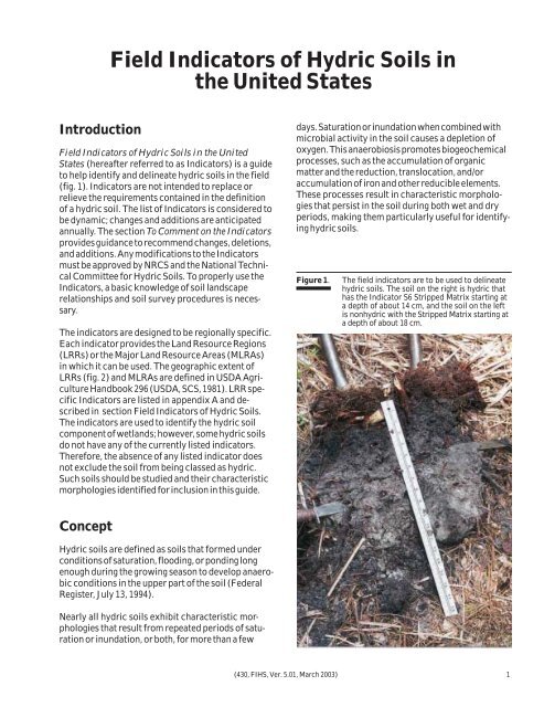
<strong>Field</strong> <strong>Indicators</strong> <strong>of</strong> <strong>Hydric</strong> <strong>Soils</strong> <strong>in</strong><strong>the</strong> <strong>United</strong> <strong>States</strong>Introduction<strong>Field</strong> <strong>Indicators</strong> <strong>of</strong> <strong>Hydric</strong> <strong>Soils</strong> <strong>in</strong> <strong>the</strong> <strong>United</strong><strong>States</strong> (hereafter referred to as <strong>Indicators</strong>) is a guideto help identify and del<strong>in</strong>eate hydric soils <strong>in</strong> <strong>the</strong> field(fig. 1). <strong>Indicators</strong> are not <strong>in</strong>tended to replace orrelieve <strong>the</strong> requirements conta<strong>in</strong>ed <strong>in</strong> <strong>the</strong> def<strong>in</strong>ition<strong>of</strong> a hydric soil. The list <strong>of</strong> <strong>Indicators</strong> is considered tobe dynamic; changes and additions are anticipatedannually. The section To Comment on <strong>the</strong> <strong>Indicators</strong>provides guidance to recommend changes, deletions,and additions. Any modifications to <strong>the</strong> <strong>Indicators</strong>must be approved by NRCS and <strong>the</strong> National TechnicalCommittee for <strong>Hydric</strong> <strong>Soils</strong>. To properly use <strong>the</strong><strong>Indicators</strong>, a basic knowledge <strong>of</strong> soil landscaperelationships and soil survey procedures is necessary.The <strong>in</strong>dicators are designed to be regionally specific.Each <strong>in</strong>dicator provides <strong>the</strong> Land Resource Regions(LRRs) or <strong>the</strong> Major Land Resource Areas (MLRAs)<strong>in</strong> which it can be used. The geographic extent <strong>of</strong>LRRs (fig. 2) and MLRAs are def<strong>in</strong>ed <strong>in</strong> USDA AgricultureHandbook 296 (USDA, SCS, 1981). LRR specific<strong>Indicators</strong> are listed <strong>in</strong> appendix A and described<strong>in</strong> section <strong>Field</strong> <strong>Indicators</strong> <strong>of</strong> <strong>Hydric</strong> <strong>Soils</strong>.The <strong>in</strong>dicators are used to identify <strong>the</strong> hydric soilcomponent <strong>of</strong> wetlands; however, some hydric soilsdo not have any <strong>of</strong> <strong>the</strong> currently listed <strong>in</strong>dicators.Therefore, <strong>the</strong> absence <strong>of</strong> any listed <strong>in</strong>dicator doesnot exclude <strong>the</strong> soil from be<strong>in</strong>g classed as hydric.Such soils should be studied and <strong>the</strong>ir characteristicmorphologies identified for <strong>in</strong>clusion <strong>in</strong> this guide.days. Saturation or <strong>in</strong>undation when comb<strong>in</strong>ed withmicrobial activity <strong>in</strong> <strong>the</strong> soil causes a depletion <strong>of</strong>oxygen. This anaerobiosis promotes biogeochemicalprocesses, such as <strong>the</strong> accumulation <strong>of</strong> organicmatter and <strong>the</strong> reduction, translocation, and/oraccumulation <strong>of</strong> iron and o<strong>the</strong>r reducible elements.These processes result <strong>in</strong> characteristic morphologiesthat persist <strong>in</strong> <strong>the</strong> soil dur<strong>in</strong>g both wet and dryperiods, mak<strong>in</strong>g <strong>the</strong>m particularly useful for identify<strong>in</strong>ghydric soils.Figure 1.The field <strong>in</strong>dicators are to be used to del<strong>in</strong>eatehydric soils. The soil on <strong>the</strong> right is hydric thathas <strong>the</strong> Indicator S6 Stripped Matrix start<strong>in</strong>g ata depth <strong>of</strong> about 14 cm, and <strong>the</strong> soil on <strong>the</strong> leftis nonhydric with <strong>the</strong> Stripped Matrix start<strong>in</strong>g ata depth <strong>of</strong> about 18 cm.Concept<strong>Hydric</strong> soils are def<strong>in</strong>ed as soils that formed underconditions <strong>of</strong> saturation, flood<strong>in</strong>g, or pond<strong>in</strong>g longenough dur<strong>in</strong>g <strong>the</strong> grow<strong>in</strong>g season to develop anaerobicconditions <strong>in</strong> <strong>the</strong> upper part <strong>of</strong> <strong>the</strong> soil (FederalRegister, July 13, 1994).Nearly all hydric soils exhibit characteristic morphologiesthat result from repeated periods <strong>of</strong> saturationor <strong>in</strong>undation, or both, for more than a few(430, FIHS, Ver. 5.01, March 2003) 1