Download the Ngāi Tahu Corporate Profile - Ngai Tahu
Download the Ngāi Tahu Corporate Profile - Ngai Tahu
Download the Ngāi Tahu Corporate Profile - Ngai Tahu

Create successful ePaper yourself
Turn your PDF publications into a flip-book with our unique Google optimized e-Paper software.
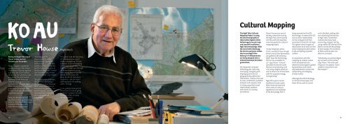
Cultural MappingDuring <strong>the</strong> <strong>Ngāi</strong> <strong>Tahu</strong> ClaimTrevor Howse workedtirelessly for his people.Trevor played a significantrole for <strong>the</strong> <strong>Ngāi</strong> <strong>Tahu</strong> MāoriTrust Board, helping organiseand drive <strong>the</strong> Claim behind<strong>the</strong> scenes. He collated a vastamount of <strong>the</strong> informationpresented to <strong>the</strong> WaitangiTribunal, managed <strong>the</strong> landbank process between <strong>Ngāi</strong><strong>Tahu</strong> and <strong>the</strong> Crown, and wasa member of <strong>the</strong> <strong>Ngāi</strong> <strong>Tahu</strong>‘A-Team’ that spearheaded <strong>the</strong>negotiation process.Today his knowledge andexpertise is once again helpingdrive ano<strong>the</strong>r important tribalinitiative in <strong>the</strong> <strong>Ngāi</strong> <strong>Tahu</strong>Cultural Mapping project.“The history of TeWaipounamu is in <strong>the</strong>footprints our tīpuna leftbehind; and today <strong>the</strong> bestevidence of <strong>the</strong>se footprintsare <strong>the</strong> names <strong>the</strong>y gave to<strong>the</strong> places <strong>the</strong>y lived, huntedand visited as <strong>the</strong>y movedabout <strong>the</strong> land,” says Trevor.“So we go back to <strong>the</strong> land,<strong>the</strong> whenua, and we put<strong>the</strong> names in place becausethat’s where <strong>the</strong> history is.Academia has given us onepart of history – we have aresponsibility to take thato<strong>the</strong>r piece and putit toge<strong>the</strong>r.”(Ngāti Kurī)“It is what I call <strong>the</strong> real storyof Te Waipounamu and ittakes in everything. It is notselective, it is encompassingand brings everythingtoge<strong>the</strong>r. It takes you throughall those questions you’vebeen asking that brings <strong>the</strong>whole of <strong>the</strong> island intoplay. We do not shut doorsanywhere – we are in factopening doors. It’s excitingwork,” he says.“I am grateful to be part of<strong>the</strong> process. If we are goingto remain a people we can’thave just a few carrying<strong>the</strong> information.”The <strong>Ngāi</strong> <strong>Tahu</strong> CulturalMapping Project is using<strong>the</strong> latest GeographicalInformation System (GIS)technology to record, mapand transmit traditional<strong>Ngāi</strong> <strong>Tahu</strong> knowledge. With<strong>the</strong> aid of GIS technology<strong>the</strong> stories and place namesthat record <strong>Ngāi</strong> <strong>Tahu</strong>history in Te Waipounamuare being mapped onto avirtual landscape for futuregenerations.GIS integrates computertechnology for capturing,managing, analysing anddisplaying all forms ofgeographically referencedinformation. It allows <strong>the</strong> userto view, understand, question,interpret and visualise datain many ways that revealrelationships, patternsand trends in a varietyof mediums.Trevor Howse was one of<strong>the</strong> key researchers during<strong>the</strong> <strong>Ngāi</strong> <strong>Tahu</strong> Claim periodand his work and expertisenow help guide <strong>the</strong> culturalmapping project.“In <strong>the</strong> timeframe of <strong>the</strong>Claim, we didn’t have enoughtime to use all <strong>the</strong> informationwe ga<strong>the</strong>red. We certainlydidn’t have <strong>the</strong> technologythat is now available tous,” says Trevor. “It is justwonderful to see <strong>the</strong> workthat we are producing, andI can only imagine what wewill be able to do in <strong>the</strong> futurewith <strong>the</strong> way technologyis progressing.”<strong>Ngāi</strong> <strong>Tahu</strong> place names,traditional travel routes,Māori reserved land ando<strong>the</strong>r areas of culturalsignificance are examplesof <strong>the</strong> knowledge that isbeing recorded on <strong>the</strong> GIStechnology. In essence <strong>the</strong> GIStool is where relationshipscan be analysed and <strong>the</strong>nvisualised in <strong>the</strong> form of maps.The system allows layers ofinformation to be laid over <strong>the</strong>land, bringing <strong>the</strong> informationto life and giving it greatercontext.In conjunction with <strong>the</strong>mapping of cultural valuesis <strong>the</strong> development of areference based system guidedby kaumātua and maraerepresentatives to ensure <strong>the</strong>au<strong>the</strong>nticity and integrityof information.Although <strong>the</strong> GIS technologyis critical to <strong>the</strong> project, <strong>the</strong>heart of <strong>the</strong> work is carriedout in <strong>the</strong> field, visiting sitesand collecting <strong>the</strong> historiesof <strong>Ngāi</strong> <strong>Tahu</strong>. Sometimescultural sites have beenincorrectly mapped, but byusing mobile GIS devices in <strong>the</strong>field to record <strong>the</strong> knowledgeof local people, <strong>the</strong> locationsof <strong>the</strong>se cultural sites canoften be corrected.“Ultimately we will be judgedby our peers at <strong>the</strong> marae,”says Trevor. This mahi willempower our people. I havewaited a long time to seethis happen.”36 37