flood hazard betwee marsa alam - ras ba as, red sea, egypt abstract ...
flood hazard betwee marsa alam - ras ba as, red sea, egypt abstract ...
flood hazard betwee marsa alam - ras ba as, red sea, egypt abstract ...

Create successful ePaper yourself
Turn your PDF publications into a flip-book with our unique Google optimized e-Paper software.
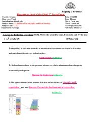
24M. A. AzabQibli, Wadi Sharm Faquri, Wadi Erier, Wadi Qulan, Wadi Radi and Wadi .Kirah El Hertawi.Drainage density is the most important me<strong>as</strong>ure of the areal <strong>as</strong>pects of the <strong>ba</strong>sins because itsimplications for runoff (Chorley 1971) and climate (Gregory 1976). Drainage density tends tobe high in semi-arid regions and in humid regions (Gregory 1976).Stream Frequency (f) is defined <strong>as</strong> the ratio of the total number of stream segments of allorders in each <strong>ba</strong>sin to the total area of the respective <strong>ba</strong>sin Horton (1954).Physiographic etwork ParametersDetermination of physiographic parameters such <strong>as</strong> <strong>ba</strong>sin shape, relief, slope sinuosity is of agreat importance <strong>as</strong> a reconnaissance tool to delineate the rainfall/runoff relationship and to<strong>as</strong>sess the surface water capacity of any hydrographic <strong>ba</strong>sin.B<strong>as</strong>in Shape controls the stream discharge from a watershed. It is numeri expressed in theform of circularity and elongation ratios. Circularity ratio (Rc) is the rati the <strong>ba</strong>sin area to thearea of a circle with the same perimeter <strong>as</strong> the <strong>ba</strong>sin (Miller 19 Elongation ratio (Re) is theratio of the diameter of a circle equal in area to the <strong>ba</strong>sin to maximum <strong>ba</strong>sin length (Schumm1956). Rc values range <strong>betwee</strong>n 0.33 and 0.98 while values range <strong>betwee</strong>n 0.39 and 0.97(Table 2). B<strong>as</strong>ins of high Rc (Wadi Samadi, Wadi Ab<strong>ba</strong>s, Wadi Sharm Luli, Wadi Dahise,Wadi EI Hertawi, Wadi Kh<strong>as</strong>hir, Wadi Um Rimari Wadi Ghadir and Wadi Khalilate EI Qibli)yield favorable conditions for shortest runoff give chance to form highly peaked <strong>flood</strong>s.Relief Ratio <strong>as</strong> expressed by Schumm (I956) is the ratio <strong>betwee</strong>n Rand L, where is theelevation difference <strong>betwee</strong>n the <strong>ba</strong>sin mouth and the highest point on the b perimeter, and Lis the maximum length of the <strong>ba</strong>sin, me<strong>as</strong>u<strong>red</strong> in the same units <strong>as</strong> R alan line essential1yparal1el to the principal channel. It is an expression of the drainage <strong>ba</strong>sin reli in a twodimensionalform, elevation and distance, and correlates better with hydrologi characteristics.B<strong>as</strong>ins with more or less unifOlm slopes result in significant relationshi <strong>betwee</strong>n relief ratioand hydrologic vaJiables such <strong>as</strong> runoff and sediment yield. The small the relief ratio, themore is the annual sediment yield and hence more dangerous durin <strong>flood</strong>ing. In theinvestigated area, the relief ratios are low (Wadi Samadi, Wadi Sharm Faqu . Wadi UmRimarim, Wadi Qulan and Wadi Satiya) and high (Wadi Ranga, Wadi Abu Ghusu and WadiKh<strong>as</strong>hir) (Table 2).Ruggedness umber is the product of drainage density and <strong>ba</strong>sin relief (Strahle1958). The incre<strong>as</strong>e of the runoff discharge is the result of the incre<strong>as</strong>ed relief and drainagedensity. In the studied area, the ruggedness number ranges from 4366 (Wadi Radi) to 365(Wadi Satayia) (Table 2). Accordingly, the pro<strong>ba</strong>bilities offload occurrence along the streamsof Wadi Ghadir, Wadi Erier, Wadi Gemal, Wadi Abu Ghusun, Wadi Ranga, Wadi Radi, WadiKh<strong>as</strong>hir and Wadi Lahmi are higher than those of the other streams. This means that the timerequi<strong>red</strong> for the runoff to flow from the highest distal ridge to the mouth (concentration time)of these streams is much shorter than that requi<strong>red</strong> for the other streams.Slope Index is the quotient of the elevation difference <strong>betwee</strong>n <strong>ba</strong>sin divide (<strong>ba</strong>sin relief) andoutlet and the main channel length (Taylor and Schwarz 1952). The main streams of WadiGemal, Wadi Qulan, Wadi Um RimaJim, Wadi Satayia and Wadi Sharm Luli are moresteeper than the that of Wadi Ghadir, Wadi Khalilate EI Qibli, Wadi Abu Ghusun, WadiRanga, Wadi Kh<strong>as</strong>hir and Wadi Urn Ghazal (Table 2). On the other hand, the upstream partsof some wadis are steeper than downstream ones and consequently, they are more favorable toyield <strong>flood</strong>s, while the lower parts are suitable to store ground water.Sinuosity is defined <strong>as</strong> the ratio of the valley length to the shortest distance <strong>betwee</strong>n mouthand source of stream (Mueller 1968). The estimated ratios indicate that streams ofWadi Ghadir, Wadi Gemal, Wadi Lahmi, Wadi Shmm Luli and Wadi Um Dahise are more