Study and Mapping of Ground Water Prospect using Remote ... - IGU
Study and Mapping of Ground Water Prospect using Remote ... - IGU
Study and Mapping of Ground Water Prospect using Remote ... - IGU

You also want an ePaper? Increase the reach of your titles
YUMPU automatically turns print PDFs into web optimized ePapers that Google loves.
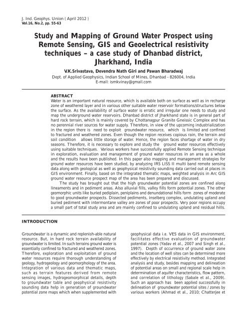
J. Ind. Geophys. Union ( April 2012 )Vol.16, No.2, pp. 55-63<strong>Study</strong> <strong>and</strong> <strong>Mapping</strong> <strong>of</strong> <strong>Ground</strong> <strong>Water</strong> <strong>Prospect</strong> <strong>using</strong><strong>Remote</strong> Sensing, GIS <strong>and</strong> Geoelectrical resistivitytechniques – a case study <strong>of</strong> Dhanbad district,Jharkh<strong>and</strong>, IndiaV.K.Srivastava, Devendra Nath Giri <strong>and</strong> Pawan BharadwajDept. <strong>of</strong> Applied Geophysics, Indian School <strong>of</strong> Mines, Dhanbad - 826004, IndiaE-mail: ismkvinay@gmail.comABSTRACT<strong>Water</strong> is an important natural resource, which is available both on surface as well as in rechargezone <strong>of</strong> weathered layer <strong>and</strong> in various other suitable water reservoir formations/structures belowthe surface. As the availability <strong>of</strong> surface water is erratic <strong>and</strong> irregular one needs to study <strong>and</strong>map the underground water reservoirs. Dhanbad district <strong>of</strong> Jharkh<strong>and</strong> state is in general part <strong>of</strong>hard rock terrain, which is mainly covered by Chottanagpur Granite Gneissic Complex <strong>and</strong> hasno perennial river sources for water supply. Therefore, in view <strong>of</strong> the upcoming industrializationin the region there is need to exploit groundwater resource, which is limited <strong>and</strong> confinedto fractured <strong>and</strong> weathered zones. Even though the region receives copious rain, the terrain <strong>and</strong>soil condition allows little storage <strong>of</strong> water. Hence, the region faces shortage <strong>of</strong> water in dryseasons. Therefore, it is necessary to explore <strong>and</strong> study the ground water resources effectively<strong>using</strong> suitable techniques. Various workers have successfully applied <strong>Remote</strong> Sensing techniquein exploration, evaluation <strong>and</strong> management <strong>of</strong> ground water resources in an area as a whole<strong>and</strong> the results have been published. In this paper also mapping <strong>and</strong> management strategies forground water resources have been studied, by analyzing IRS LISS II multi b<strong>and</strong> remote sensingdata along with geological as well as geophysical resistivity sounding data carried out at places inGIS environment. Finally, based on the integrated thematic maps, weighted analysis in Arc GISground water resource prospect map <strong>of</strong> the area has been prepared <strong>and</strong> discussed.The study has brought out that the high groundwater potential zones are confined alonglineaments <strong>and</strong> in pediment areas. Also alluvial fills, valley fills form potential zones. The othergeomorphic units like buried pediplain, peniplains <strong>and</strong> denundational hills form zones <strong>of</strong> moderateto good groundwater prospects. Dissected pediments, inselberg complex, undulating upl<strong>and</strong> <strong>and</strong>buried pediment with intermontane valley are zones <strong>of</strong> poor prospects. Very poor regions occupya small part <strong>of</strong> total study area <strong>and</strong> are mainly confined to undulating upl<strong>and</strong> <strong>and</strong> residual hills.INTRODUCTION<strong>Ground</strong>water is a dynamic <strong>and</strong> replenish-able naturalresource. But, in hard rock terrain availability <strong>of</strong>groundwater is limited. In such terrains ground water isessentially confined to fractured <strong>and</strong> weathered zones.Therefore, exploration <strong>and</strong> exploitation <strong>of</strong> groundwater resources require thorough underst<strong>and</strong>ing <strong>of</strong>geology, hydrogeology <strong>and</strong> geomorphology <strong>of</strong> the area.Integration <strong>of</strong> various data <strong>and</strong> thematic maps,such as terrain features derived from remotesensing images, hydrogeomorphical details, depthto groundwater table <strong>and</strong> geophysical resistivitysounding data help in generation <strong>of</strong> groundwaterpotential zone maps which when supplemented withgeophysical data i.e. VES data in GIS environment,facilitates effective evaluation <strong>of</strong> groundwaterpotential zones (Yadav et al., 2007 <strong>and</strong> Singh et al.,1997). Depth <strong>of</strong> occurrence <strong>of</strong> ground water zone<strong>and</strong> the location <strong>of</strong> well sites can be determined moreeffectively by electrical resistivity method. Integratedanalysis <strong>and</strong> study, besides mapping <strong>and</strong> delineation<strong>of</strong> potential areas on small <strong>and</strong> regional scale help indetermination <strong>of</strong> aquifer characteristics, flow pattern,<strong>and</strong> correlation <strong>of</strong> lithology (Sabale et al., 2009).Such an approach has been applied successfully indelineation <strong>of</strong> groundwater potential sites / zones byvarious workers (Ahmad et al., 2010; Chatterjee et
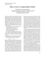
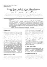
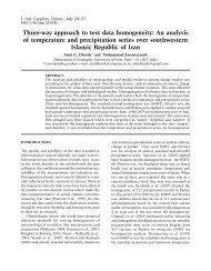
V.K.Srivastava, Devendra Nath Giri <strong>and</strong> Pawan Bhardwajal., 2010; Lokesh et al., 2005; Mondal et al., 2007;Rao et al., 2009; Banerji, 2000; Srivastava, 2000 <strong>and</strong>Dasgupta, 1994).The present study area, which is a hard rockterrain, having undulating topography though getsufficient rainfall, suffers from water scarcity fordomestic, agricultural, <strong>and</strong> industrial purposes due tolimited nature <strong>of</strong> aquifers (inadequate weathered <strong>and</strong>fissured zones). Also, sometimes presence <strong>of</strong> basic<strong>and</strong> meta-basic dykes <strong>and</strong> the quartz reefs in the areahave acted as barriers for the flow <strong>of</strong> water (Singhet al., 1997). Taking into consideration the abovescenario an attempt has been made for mapping <strong>of</strong>ground water potential zones, by integrating variousthematic maps, as generated from processed <strong>and</strong>enhanced remote sensing multi b<strong>and</strong> data, digitalelevation model (DEM) created from SRTM dataalong with vertical electrical survey (VES) data <strong>and</strong>other geo hydrological data in GIS environment.LOCATION, GENERAL GEOLOGY ANDHYDROLOGICAL SET UP OF THE AREAOur study area, Dhanbad district is situated inbetween 23 0 37’30”N - 24 0 56’N lat <strong>and</strong> 86 0 8’23”E- 86 0 50’18”E long, in Jharkh<strong>and</strong> state <strong>of</strong> EasternIndia ( Figure 1). The northern boundary <strong>of</strong> which ismarked by Barakar river <strong>and</strong> the southern boundaryby Damodar river, on which two important reservoirsviz Maithon <strong>and</strong> Panchet are located respectively.The region lies on the eastern part <strong>of</strong> Chhotanagpurplateau <strong>and</strong> has an undulating topography with threeFigure 1. Location map <strong>of</strong> Dhanbad District, Jharkh<strong>and</strong>.56
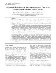
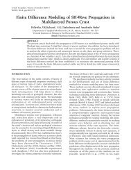
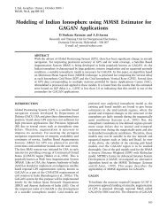
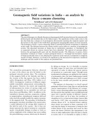
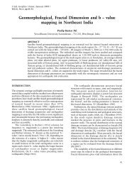
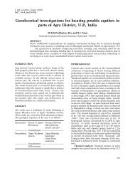
<strong>Study</strong> <strong>and</strong> <strong>Mapping</strong> <strong>of</strong> <strong>Ground</strong> <strong>Water</strong> <strong>Prospect</strong> <strong>using</strong> <strong>Remote</strong> Sensing, GIS <strong>and</strong>Geoelectrical resistivity techniques – a case study <strong>of</strong> Dhanbad district, Jharkh<strong>and</strong>, Indiadistinct geomorphic features from north to south, (a)the hill ranges in north western part, (b) the coal fieldin southern <strong>and</strong> eastern part, <strong>and</strong> (c) the undulatingupl<strong>and</strong> <strong>and</strong> intervening alluvial fill low valleys withisolated bare ridges between them in north. Themetamorphic terrain <strong>of</strong> the region is underlain bya wide range <strong>of</strong> geological formations ranging inage from Archaean to Recent. The Archeans <strong>and</strong>Gondwanas constitute the major parts.Thin veneer <strong>of</strong>Quaternary alluvial deposits occurs in the topographicdepressions along the Damodar <strong>and</strong> Barakar Rivers(Figure 2). Our study is restricted to this Achaeanterrain only.In this terrain ground water occurs underunconfined condition in the weathered zone <strong>of</strong>consolidated or unconsolidated rocks <strong>and</strong> in thefractured zone immediately below the weatheredzone. It also occurs under semi confined <strong>and</strong> confinedstates in deep fracture zones in the metamorphic<strong>and</strong> sedimentary rocks. <strong>Ground</strong>water in such rockscirculates through the secondary openings representedby joints, cracks, fissures <strong>and</strong> such other planes <strong>of</strong>discontinuity. The weathered residuum <strong>of</strong> the hardrocks as well as the fractures, joints, fissures, faults<strong>and</strong> other zones <strong>of</strong> discontinuity are the principlerepositories <strong>of</strong> groundwater in the area (Banerji,2000).DATA AND METHODOLOGY USEDDetails pertaining to the data, processing methodology<strong>and</strong> analysis followed in the present study (mapping<strong>of</strong> <strong>Ground</strong> <strong>Water</strong> Resources prospect map <strong>of</strong> Dhanbaddistrict <strong>using</strong> remote sensing, Digital ElevationModel (DEM) <strong>and</strong> conventional Electrical ResistivitySounding (VES) data in GIS environment) aredescribed briefly.Multi b<strong>and</strong> remote sensing digital data sets <strong>of</strong>IRS LISS II have been radio metrically processed,enhanced <strong>and</strong> geo corrected <strong>using</strong> SOI toposheetno. 73/I. Finally st<strong>and</strong>ard false color composite(FCC) was generated in ENVI s<strong>of</strong>tware for delineatinggeneral rock types, l<strong>and</strong>forms, geological structuresetc. based on characteristic photo signatures (Figure3).This was then integrated with published geologicalmap (Figure 2) <strong>and</strong> <strong>Ground</strong> <strong>Water</strong> Table depthmap from CGWB report (Figure 4) in Arc GISenvironment.Further the resulting maps were again integratedwith Digital Elevation Model (DEM) <strong>of</strong> the regionFigure 2. Map showing General Geology <strong>of</strong> study area (after Krishnan, 1982).57
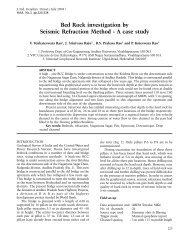
V.K.Srivastava, Devendra Nath Giri <strong>and</strong> Pawan BhardwajFigure 3. IRS LISS II st<strong>and</strong>ard FCC (Geo corrected) image <strong>of</strong> Dhanbad District.58Figure 4. <strong>Ground</strong> <strong>Water</strong> Table depth map (after CGWB Report, 2000).
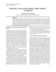
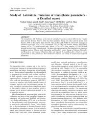
<strong>Study</strong> <strong>and</strong> <strong>Mapping</strong> <strong>of</strong> <strong>Ground</strong> <strong>Water</strong> <strong>Prospect</strong> <strong>using</strong> <strong>Remote</strong> Sensing, GIS <strong>and</strong>Geoelectrical resistivity techniques – a case study <strong>of</strong> Dhanbad district, Jharkh<strong>and</strong>, Indiaas generated from US- Shuttle Radar TopographicMission (SRTM) data (Figure 5) with spatialresolution <strong>of</strong> 90 m down loaded from site www.srtm.csi.cgiar.org <strong>and</strong> checked with the aquiferdepths as interpreted from typical vertical electricalsounding (VES) curve carried out at selected points(Figure 6). In Figure 6 the first layer corresponds tosoil cover <strong>and</strong> weathered zone with depth around 5m <strong>and</strong> <strong>of</strong> 50 ohm meter resistivity value. This showsthe possibility <strong>of</strong> groundwater occurrence, in goodquantity, in this layer compared to the underlyinglayers. The first layer is underlain by semi weatheredFigure 5. SRTM -Digital Elevation Model (DEM) <strong>of</strong> Dhanbad District.Figure 6. Vertical Electrical Sounding Resistivity curve <strong>and</strong> modeled section.59
V.K.Srivastava, Devendra Nath Giri <strong>and</strong> Pawan Bhardwaj2 nd layer <strong>of</strong> thickness 9-10 m with resistivity value <strong>of</strong>about 214 ohm mt. Underneath, weathered rocks arefound. There is a probability that this second layermay have some non-interconnected fractured zoneswith ground water, with no circulation. Whereas, thethird layer with resistivity value <strong>of</strong> 144 ohm mt maybe inferred as the zone that outlines the channelsalong which groundwater appears to flow. This couldbe a good potential zone. Finally , all the thematicmaps were overlaid <strong>and</strong> analyzed <strong>using</strong> weightedoverlay technique <strong>of</strong> spatial analysis tool in ArcGIS 9. This technique provides a method forcombining multiple thematic maps by applying acommon measurement scale <strong>of</strong> values to each raster,weighting each according to its importance, <strong>and</strong>adding them together to create an integrated map.In the present study the weighted overlay analysishas been carried out by giving weight to individualparameters as class weights <strong>and</strong> thematic maps asweighted theme, according to their degree <strong>of</strong> prospect(Table 1) for generating Hydro-geomorphological map(Figure 7) <strong>and</strong> <strong>Ground</strong> <strong>Water</strong> <strong>Prospect</strong> map (Figure 8).Figure 7. Hydro Geomorphological Map <strong>of</strong> Dhanbad District (after Banerjee,2000).60
<strong>Study</strong> <strong>and</strong> <strong>Mapping</strong> <strong>of</strong> <strong>Ground</strong> <strong>Water</strong> <strong>Prospect</strong> <strong>using</strong> <strong>Remote</strong> Sensing, GIS <strong>and</strong>Geoelectrical resistivity techniques – a case study <strong>of</strong> Dhanbad district, Jharkh<strong>and</strong>, IndiaTable 1. Different themes <strong>and</strong> thematic parameters considered for groundwater prospects evaluation <strong>and</strong> their classweightsGeomorphology(Theme Weight – 40)Geology(Theme Weight – 20)Underground <strong>Water</strong>Table map m b.g.l.( below ground level )(Theme Weight- 20)Digital ElevationModel (Contour) Map(Theme weight- 20)Categories ClassWeightCategories ClassWeightCategories ClassWeightCategories ClassWeightDenundational Hills 6 Granite Gneiss 2 upto 3 m 8 500 - 1200 2Residual Hillb.g.l.mPediment 8 Archean 4 3-6 m b.g.l. 6 301 - 500 m 6Hillocks <strong>and</strong> Mounds 2 Talchir 4 6-9 m b.g.l. 6 151 - 300 m 4Pediment Inselberg 2 Raniganj 6 9-12 m b.g.l. 2 0 - 150 m 6ComplexPeneplaine / pediplain 4 Barren 6MeasureBarakar 4Figure 8. Final <strong>Ground</strong> water prospect map <strong>of</strong> Dhanbad District61
V.K.Srivastava, Devendra Nath Giri <strong>and</strong> Pawan BhardwajRESULTS AND DISCUSSIONOn the basis <strong>of</strong> integrated <strong>and</strong> weighted analysis<strong>of</strong> various thematic maps such as geological, geomorphological, digital elevation model, verticalelectrical resistivity sounding data, ground water tabledepth map <strong>and</strong> geo morphological map in Arc GIS,we have generated two very important maps viz.; A)Hydro-geomorphological map (Figure 7) showinggroundwater potentiality in terms <strong>of</strong> geomorphology<strong>and</strong> B) <strong>Ground</strong> <strong>Water</strong> <strong>Prospect</strong> Map (Figure 8) <strong>of</strong>Dhanbad district.A) Hydro-geomorphological MapThis map shows five distinct hydro geo morphologicalfeatures from the point <strong>of</strong> view <strong>of</strong> water resourceprospect as well as for application <strong>of</strong> watermanagement practices, in order to enhance the status<strong>of</strong> water resources in the region.Unit 1) - Denudational Hills: The area is coveredwith mixed forest <strong>and</strong> has moderate to low sloperesulting in moderate run <strong>of</strong>f. It is shallow <strong>and</strong> welldrained. It is gravelly loamy soil <strong>and</strong> non-sticking.It is friable when moist. The region is covered with fewlineaments/fractures with subradial drainage pattern <strong>and</strong>hence the groundwater prospect is moderate to good.Unit 2) - Pediment: The area is covered withbushes with cultivated l<strong>and</strong> in low valley <strong>and</strong> hasmoderate to steep slopes (5-10%). The region hasdense lineaments. Drainage pattern is dendriticto sub parallel with linear parallel radial drainagepattern. The groundwater prospect is good to verygood.Unit 3) - Undulating Upl<strong>and</strong>: These featuresrepresent the buried pediments with intermontanevalley. These areas are characterized by moderateto high steep slope resulting in very high run <strong>of</strong>f.<strong>Ground</strong>water prospect is poor.Unit 4) - Pediment Inselberg Complex:These are isolated rock hills, knobs, ridges, orsmall mountains that rise abruptly from a gentlysloping or virtually level surrounding plain. The unitrepresents barren l<strong>and</strong> with shallow well drainedgravelly s<strong>and</strong>y soil on sloping l<strong>and</strong>scape with severeerosion. Drainage density is poor with sub parallel tosub radial pattern <strong>and</strong> groundwater prospect is poor.Unit 5) – Pedeplain / Peneplain: Pedeplains arerelatively flat rock surfaces formed by the joining <strong>of</strong>several pediments <strong>and</strong> Peneplains. They are gentlyundulating, almost featureless <strong>and</strong> plain. The regionis covered with moderate number <strong>of</strong> lineamentswith sub parallel to sub dendritic drainage pattern.<strong>Ground</strong>water prospect is low to moderate.B) <strong>Ground</strong> <strong>Water</strong> <strong>Prospect</strong> MapThe final integrated map as generated by applyingthe weighted overlay analysis in Arc GIS showsfive prospect grades in terms <strong>of</strong> water resourcespotentiality viz.; very good, good, moderate, poor<strong>and</strong> very poor (Figure 8). Good <strong>Water</strong> prospectzone Geomorphologically covering alluvial fills <strong>and</strong>valley fills covers nearly 45% area (yellowish greencolor tone) . Very good zones cover only 12% <strong>of</strong> thestudy area (green color tone). They are locatedalong lineaments <strong>and</strong> in pediment areas. Moderateprospect zone covers 15% <strong>of</strong> the area (yellowish colortone). Features like buried pediplains, peniplains<strong>and</strong> denundational hills come under this category.Whereas poor regions cover up to 22% (orangecolor tone). These features are mainly confinedto undulating upl<strong>and</strong> <strong>and</strong> buried pediments withintermontane valley. Lastly, very poor groundwaterprospect zones are approximately 10% (red colortone). These features include dissected pediments,inselberg complex <strong>and</strong> residual hills.CONCLUSIONSThe present integrated study has brought out thefollowing conclusions.Geologically it is observed that the groundwater ismainly confined to secondary porosity i.e. fracturedzone, fault, joint <strong>and</strong> weathered column. It isobserved from field survey <strong>and</strong> also from variouswells located in the region the hard granite gneisses<strong>and</strong> meta basic dykes sometimes act as barriers forthe groundwater flow in the region.Based on resistivity variation with depth, it ispossible to estimate the depth <strong>and</strong> distribution <strong>of</strong>groundwater. The low resistivity value <strong>of</strong> less than51ohm-m indicates the presence <strong>of</strong> weathered zone,which is favorable for groundwater accumulation.The subsequent underlying layers (hard <strong>and</strong> massiverocks) are more resistive than the first layer.From the generated ground water resourceprospect map, it is observed that high potential zonesare mainly located along lineaments <strong>and</strong> in pedimentareas. Alluvial fills, valley fills are good potentialzones. The geomorphic units like buried pediplains,peniplains <strong>and</strong> denundational hills are moderate togood groundwater prospective zones. Undulatingupl<strong>and</strong> <strong>and</strong> buried pediments with intermontanevalley, mainly confined in undulating upl<strong>and</strong>, arethe regions <strong>of</strong> poor groundwater prospecting zones.Very poor potential regions cover a small part <strong>of</strong> totalstudy area (confined to dissected pediments, inselbergcomplex <strong>and</strong> residual hills).62
<strong>Study</strong> <strong>and</strong> <strong>Mapping</strong> <strong>of</strong> <strong>Ground</strong> <strong>Water</strong> <strong>Prospect</strong> <strong>using</strong> <strong>Remote</strong> Sensing, GIS <strong>and</strong>Geoelectrical resistivity techniques – a case study <strong>of</strong> Dhanbad district, Jharkh<strong>and</strong>, IndiaACKNOWLEDGEMENTAuthors express their thanks to the Director, IndianSchool <strong>of</strong> Mines (ISM) Dhanbad, India for extendingall the facilities to carry out the present work. Thepresent work is the part <strong>of</strong> the Dissertation worksubmitted at the Dept. <strong>of</strong> Applied Geophysics, ISM,Dhanbad by junior author, Mr Devendra Kumar Giri.REFERENCESAhmad, M.I., Jahan, C.S., Mazumdar, Q.H., HossainM.M.A., & Haque, A., 2010. <strong>Study</strong> <strong>of</strong> <strong>Ground</strong>waterRecharge Potentiality <strong>of</strong> Barind Tract, RagshahiDistrict, Bangladesh Using GIS <strong>and</strong> <strong>Remote</strong> SensingTechnique. Geological Society <strong>of</strong> India, 75: 432-438.Benerji, I., 2000. Hydrogeology <strong>and</strong> <strong>Ground</strong>water Resources<strong>of</strong> Dhanbad District, Unpublished CGWB report.Chatterjee, R., Tarafder, G. & Paul, S., 2010. <strong>Ground</strong>waterQuality Assessment <strong>of</strong> Dhanbad District, Jharkh<strong>and</strong>,India. Bulletin <strong>of</strong> Engineering Geology <strong>and</strong> theEnvironment, 69: 137-141.Dasgupta, S., 1994. Physico Chemical studies on <strong>Water</strong>Resources <strong>and</strong> its relation to lithology to DhanbadDistrict, Bihar India, Indian Journal <strong>of</strong> Earth Scinces,21(2): 69-78.Krishnan, M.S., 1982. Geology <strong>of</strong> India <strong>and</strong> Burma. CBSPublisher, New Delhi, 6 th Edition, 1-536.Lokesh, N., Gopalakrishna, G.S., Gowda, H.H. & Gupta,A.K., 2005. Delineation <strong>of</strong> <strong>Ground</strong>water PotentialZones in a Hard Rock Terrain <strong>of</strong> Mysore District,Karnataka Using IRS Data <strong>and</strong> GIS Techniques.Journal <strong>of</strong> the Indian Society <strong>of</strong> <strong>Remote</strong> Sensing,33(3): 405-412.Mondal, M.S., P<strong>and</strong>ey, A.C. & Garg, R.D., 2007. <strong>Ground</strong>water<strong>Prospect</strong> Evaluation Based on Hydrogeomorphological<strong>Mapping</strong> <strong>using</strong> High Resolution Satellite Images: Acase study in Uttarakah<strong>and</strong>. Journal <strong>of</strong> the IndianSociety <strong>of</strong> <strong>Remote</strong> Sensing, 36(1): 69-76.Rao, P.J., Harikrishna, P., Srivastava, S.K., Satyanarayana,P.V.V. & Rao, B.V.D., 2009. Selection <strong>of</strong> <strong>Ground</strong>waterPotential Zones in <strong>and</strong> around Madhurawada Dome,Visakhapatnam District - A GIS Approach. TheJournal <strong>of</strong> Indian Geophysical Union, 13(4): 191-200.Sabale, S.M., Ghodake, V.R. & Narayanpethkar, A.B., 2009.Electrical Resistivity Distribution Studies for ArtificialRecharge <strong>of</strong> <strong>Ground</strong>water in The Dhubdhubi Basin,Solapur District, Maharashtra, India. The Journal <strong>of</strong>Indian Geophysical Union, 13(4): 201-207.Singh, J. & Jha, B.P., 1997. Resistivity Pr<strong>of</strong>iles over QuartzReefs <strong>of</strong> Dhanbad. Pure <strong>and</strong> Applied Geophysics,97(1972/4): 127-136.Srivastava, V.K., 2000. <strong>Water</strong> Resources Managementthrough <strong>Remote</strong> Sensing <strong>and</strong> GIS: A Case <strong>Study</strong> <strong>of</strong>Dhanbad <strong>Water</strong>shed. Proc. <strong>of</strong> National Seminar onGeo informatics held at Coimbatore: p 238-243.Yadav, G.S. & Singh, S.K., 2007. Integrated ResistivitySurveys for Delineation <strong>of</strong> Fractures for <strong>Ground</strong>waterExploration in Hard Rock Areas. Journal <strong>of</strong> AppliedGeophysics, 62: 301-312.Pr<strong>of</strong> V K Srivastava, a senior Pr<strong>of</strong>essor <strong>of</strong> Indian School <strong>of</strong> Mines, Dhanbad has teaching<strong>and</strong> research experience in different branches <strong>of</strong> Geophysics. He has published about60 research papers in various national <strong>and</strong> international journals in addition to some inproceedings <strong>of</strong> various Conferences <strong>and</strong> Seminars. He has been awarded several ForeignGovt Fellowships to visit abroad as Exchange Scientist/Scholar in particular as FulbrightFellow in US, DAAD Fellow in Germany, Indo Netherl<strong>and</strong> Scholar in the Netherl<strong>and</strong><strong>and</strong> Visiting Scientist in Russia. During his stay in US, he had an opportunity to workat Jet Propulsion Lab <strong>of</strong> NASA where he did work on Airborne Imaging SpectrometricData. He has completed several sponsored R& D <strong>and</strong> consultancy projects. Currently hisfields <strong>of</strong> interest are <strong>Remote</strong> Sensing <strong>and</strong> GIS, Environmental Geophysics, Seismology,Paleoseismology <strong>and</strong> Digital Terrain Modelling.Pawan Bharadwaj, a final year student <strong>of</strong> M Sc Tech Five year Integrated course <strong>of</strong> AppliedGeophysics Dept has started his career through JEE in 2007 at Indian School <strong>of</strong> Mines,Dhanbad. He has been actively working on projects involving <strong>Remote</strong> Sensing, GIS <strong>and</strong>Seismic Interferometery. His work has recently been published in International Journals(‘The Leading Edge’ <strong>and</strong> ‘Geophysical Journal International’).63