PART 1 â GENERAL (GEN)
PART 1 â GENERAL (GEN)
PART 1 â GENERAL (GEN)

You also want an ePaper? Increase the reach of your titles
YUMPU automatically turns print PDFs into web optimized ePapers that Google loves.
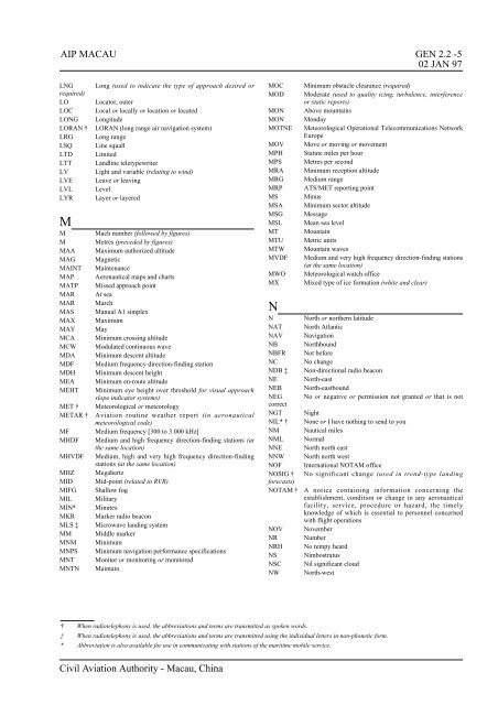
AIP MACAU <strong>GEN</strong> 2.2 -502 JAN 97LNGrequired)LOLOCLONGLORAN †LRGLSQLTDLTTLVLVELVLLYRMMMMAAMAGMAINTMAPMATPMARMARMASMAXMAYMCAMCWMDAMDFMDHMEAMEHTMET †METAR †MFMHDFMHVDFMHZMIDMIFGMILMIN*MKRMLS ‡MMMNMMNPSMNTMNTNLong (used to indicate the type of approach desired orLocator, outerLocal or locally or location or locatedLongitudeLORAN (long range air navigation system)Long rangeLine squallLimitedLandline teletypewriterLight and variable (relating to wind)Leave or leavingLevelLayer or layeredMach number (followed by figures)Metres (preceded by figures)Maximum authorized altitudeMagneticMaintenanceAeronautical maps and chartsMissed approach pointAt seaMarchManual A1 simplexMaximumMayMinimum crossing altitudeModulated continuous waveMinimum descent altitudeMedium frequency direction-finding stationMinimum descent heightMinimum en-route altitudeMinimum eye height over threshold for visual approachslope indicator systems)Meteorological or meteorologyAviation routine weather report (in aeronauticalmeteorological code)Medium frequency [300 to 3 000 kHz]Medium and high frequency direction-finding stations (atthe same location)Medium, high and very high frequency direction-findingstations (at the same location)MegahertzMid-point (related to RVR)Shallow fogMilitaryMinutesMarker radio beaconMicrowave landing systemMiddle markerMinimumMinimum navigation performance specificationsMonitor or monitoring or monitoredMaintainMOCMODMONMONMOTNEMOVMPHMPSMRAMRGMRPMSMSAMSGMSLMTMTUMTWMVDFMWOMXNMinimum obstacle clearance (required)Moderate (used to quality icing, turbulence, interferenceor static reports)Above mountainsMondayMeteorological Operational Telecommunications NetworkEuropeMove or moving or movementStatute miles per hourMetres per secondMinimum reception altitudeMedium rangeATS/MET reporting pointMinusMinimum sector altitudeMessageMean sea levelMountainMetric unitsMountain wavesMedium and very high frequency direction-finding stations(at the same location)Meteorological watch officeMixed type of ice formation (white and clear)N North or northern latitudeNAT North AtlanticNAV NavigationNB NorthboundNBFR Not beforeNC No changeNDB ‡ Non-directional radio beaconNE North-eastNEB North-eastboundNEG No or negative or permission not granted or that is notcorrectNGT NightNIL* † None or I have nothing to send to youNM Nautical milesNML NormalNNE North north eastNNW North north westNOF International NOTAM officeNOSIG † No significant change (used in trend-type landingforecasts)NOTAM † A notice containing information concerning theestablishment, condition or change in any aeronauticalfacility, service, procedure or hazard, the timelyknowledge of which is essential to personnel concernedwith flight operationsNOV NovemberNR NumberNRH No rempy heardNS NimbostratusNSC Nil significant cloudNW North-west† When radiotelephony is used, the abbreviations and terms are transmitted as spoken words.‡ When radiotelephony is used, the abbreviations and terms are transmitted using the individual letters in non-phonetic form.* Abbreviation is also available for use in communicating with stations of the maritime mobile service.Civil Aviation Authority - Macau, China