Appendix A â Work Breakdown Structure (WBS)
Appendix A â Work Breakdown Structure (WBS)
Appendix A â Work Breakdown Structure (WBS)

You also want an ePaper? Increase the reach of your titles
YUMPU automatically turns print PDFs into web optimized ePapers that Google loves.
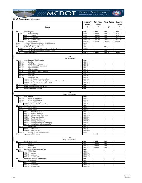
<strong>Work</strong> <strong>Breakdown</strong> <strong>Structure</strong>TasksScoping Pre-Final Final Tasks SealedTasks TasksTasksD P F S100.6. - Project ProgressD.100.6 P.100.6 F.100.6 S.100.6100.6.1. - Progress MeetingsD.100.6.1 P.100.6.1 F.100.6.1 S.100.6.1100.6.1.1 - AgendaD.100.6.1.1 P.100.6.1.1 F.100.6.1.1 S.100.6.1.1100.6.1.2 - AttendanceD.100.6.1.2 P.100.6.1.2 F.100.6.1.2 S.100.6.1.2100.6.1.3 - Meeting NotesD.100.6.1.3 P.100.6.1.3 F.100.6.1.3 S.100.6.1.3100.6.2. - Progress ReportsD.100.6.2 P.100.6.2 F.100.6.2 S.100.6.2100.7. - Determine VE Study Requirement - PM&C ManagerD.100.7100.8. - Project Programming and FundingD.100.8100.9. - Field Walk with Project TeamD.100.9 F.100.9100.9.1. - Field Walk during Draft Scoping Plans Submittal ReviewD.100.9.1100.9.2. - Field Walk during Final Plans Submittal ReviewF.100.9.2100.10. - Project AdministrationD.100.10 P.100.10 F.100.10 S.100.10200Data Acquisition200.1. - Project Research / Data CollectionD.200.1200.1.1. - Photo logD.200.1.1200.1.2. - As-Built / Record DrawingsD.200.1.2200.1.3. - Prior Studies and DocumentationD.200.1.3200.1.4. - Improvement PlansD.200.1.4200.1.5. - Technical ReportsD.200.1.5200.1.6. - Utility As-Builts / Records DrawingsD.200.1.6200.1.7. - Right-of-WayD.200.1.7200.1.8. - Traffic DataD.200.1.8200.1.9. - Geotechnical DataD.200.1.9200.1.9.1 - Preliminary Geotechnical DataD.200.1.9.1200.1.9.2 - Prepare and Submit Boring Locations and Site Access PlanD.200.1.9.2200.1.9.3 - Pre-Final Geotechnical Data / FieldworkD.200.1.9.3200.2. - Review Acquired DataD.200.2200.3. - Identify Additional Information NeedsD.200.3200.4. - Site Visit and Project ResearchD.200.4300Survey and Mapping300.1. - Aerial MappingD.300.1300.1.1. - Request Aerial MappingD.300.1.1300.1.2. - Perform Aerial MappingD.300.1.2300.1.3. - Provide Aerial MappingD.300.1.3300.1.3.1 - Provide Rectified Ortho PhotosD.300.1.3.1300.2. - Topographic SurveyD.300.2300.2.1. - Request SurveyD.300.2.1300.2.2. - Perform SurveyD.300.2.2300.2.2.1 - Geometric ControlD.300.2.2.1300.2.2.2 - Ground CoordinatesD.300.2.2.2300.2.2.3 - Alignments and CenterlinesD.300.2.2.3300.2.2.4 - Topographic MappingD.300.2.2.4300.2.2.5 - Elevation ControlD.300.2.2.5300.2.2.6 - Existing Utility MappingD.300.2.2.6300.2.2.7 - Existing Traffic Signing and StripingD.300.2.2.7300.2.2.8 - Existing Right-of-Way InformationD.300.2.2.8300.2.3. - Provide SurveyD.300.2.3300.2.3.1 - Field NotesD.300.2.3.1300.2.3.2 - Electronic FilesD.300.2.3.2300.2.4. - Verify Survey Data in Office and FieldD.300.2.4300.3. - Supplemental Field SurveyP.300.3400Project Coordination400.1. - Stakeholder MeetingsD.400.1 P.400.1 F.400.1400.1.1. - AgendaD.400.1.1 P.400.1.1 F.400.1.1400.1.2. - AttendanceD.400.1.2 P.400.1.2 F.400.1.2400.1.3. - Meeting NotesD.400.1.3 P.400.1.3 F.400.1.3400.2. - Technical Advisory Committee (TAC)D.400.2400.2.1. - TAC MeetingsD.400.2.1400.2.1.1 - AgendaD.400.2.1.1400.2.1.2 - AttendanceD.400.2.1.2400.2.1.3 - Meeting NotesD.400.2.1.3400.3. - Stakeholder Advisory Committee (SAC)D.400.3400.3.1. - SAC MeetingsD.400.3.1400.3.1.1 - AgendaD.400.3.1.1400.3.1.2 - AttendanceD.400.3.1.2400.3.1.3 - Meeting NotesD.400.3.1.3<strong>WBS</strong>Page 2 of 153/26/2013