Public reports pack PDF 8 MB - Agendas, Meetings and Minutes
Public reports pack PDF 8 MB - Agendas, Meetings and Minutes
Public reports pack PDF 8 MB - Agendas, Meetings and Minutes

Create successful ePaper yourself
Turn your PDF publications into a flip-book with our unique Google optimized e-Paper software.
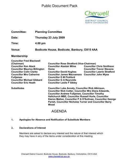
<strong>Public</strong> Document PackCommittee:Planning CommitteeDate: Thursday 23 July 2009Time:Venue4.00 pmBodicote House, Bodicote, Banbury, OX15 4AAMembershipCouncillor Fred Blackwell(Chairman)Councillor Ken AtackCouncillor Maurice BillingtonCouncillor Colin ClarkeCouncillor Mrs CatherineFulljamesCouncillor Michael GibbardCouncillor Eric HeathSubstitutesCouncillor Rose Stratford (Vice-Chairman)Councillor Alastair Milne Councillor Chris SmithsonHomeCouncillor Trevor StevensCouncillor David Hughes Councillor Lawrie StratfordCouncillor James Macnamara Councillor John WyseCouncillor D M PickfordCouncillor G A ReynoldsCouncillor Leslie F SibleyCouncillor Luke Annaly, Councillor Rick Atkinson,Councillor Nick Cotter, Councillor Mrs Diana Edwards,Councillor Andrew Fulljames, Councillor TimothyHallchurch <strong>MB</strong>E, Councillor Russell Hurle, CouncillorKieron Mallon, Councillor P A O'Sullivan, Councillor GeorgeParish, Councillor Nicholas Turner <strong>and</strong> Councillor BarryWoodAGENDA1. Apologies for Absence <strong>and</strong> Notification of Substitute Members2. Declarations of InterestMembers are asked to declare any interest <strong>and</strong> the nature of that interest whichthey may have in any of the items under consideration at this meetingCherwell District Council, Bodicote House, Bodicote, Banbury, Oxfordshire, OX15 4AAwww.cherwell-dc.gov.uk
3. Petitions <strong>and</strong> Requests to Address the MeetingThe Chairman to report on any requests to submit petitions or to address themeeting.4. Urgent BusinessThe Chairman to advise whether they have agreed to any item of urgent businessbeing admitted to the agenda.5. <strong>Minutes</strong> (Pages 1 - 8)To confirm as a correct record the <strong>Minutes</strong> of the meeting of the Committee heldon 2 July 2009.Planning Applications6. Fant Hill Farmhouse, Hayway Lane, Hook Norton, OxfordshireOX15 5QJ (Pages 11 - 20)7. Old Barton, High Street, Shutford, Oxfordshire, OX15 6PQ(Pages 21 - 29)8. The Gate Lodge, 43 Mill Street, Kidlington OX5 2EE (Pages 30- 34)09/00225/F09/00371/F09/00414/OBL9. Lower Tadmarton, Banbury, Oxon, OX15 5HL (Pages 35 - 41) 09/00553/F10. Souldern Gate Garage, Souldern, Bicester, Oxfordshire OX277JL (Pages 42 - 51)11. L<strong>and</strong> Watts Way to the rear <strong>and</strong> north of 25 High Street, HighStreet, Kidlington (Pages 52 - 56)09/00719/F09/00749/CDCInformation Reports12. Proposed Railway Improvement Scheme Between Bicester <strong>and</strong> Oxford(Pages 57 - 68)Report of the Head of Development Control <strong>and</strong> Major DevelopmentsSummaryTo inform Members of the proposed improvements to the railway line betweenBicester <strong>and</strong> Oxford as part of the proposals by Chiltern Railways for a new routebetween Oxford <strong>and</strong> London, so they are aware of the proposal prior to detailedproposals for the scheme being submitted.
RecommendationsThat Members note the report <strong>and</strong> the response provided by the Executive to theconsultation from Chiltern Railways.Tree Preservation Orders13. Tree Preservation Order (No. 5) 2009 Lime Tree at Cope Road / Arran Grove,Banbury (Pages 69 - 71)Report of Head of Development Control <strong>and</strong> Major DevelopmentsSummaryTo seek the confirmation of an unopposed Tree Preservation Order relating to aLime Trees at Cope Road/Arran Grove, Banbury (copy plan attached as Annex 1).RecommendationIt is RECOMMENDED that the Committee resolves to confirm the Order withoutmodification.Review <strong>and</strong> Monitoring Reports14. Decisions Subject to Various Requirements - Progress Report (Pages 72 - 73)Report of the Head of Development Control <strong>and</strong> Major DevelopmentsSummaryThis is a st<strong>and</strong>ard report item the aim of which is to keep Members informed uponapplications which they have authorised decisions upon subject to variousrequirements which must be complied with prior to the issue of decisions.RecommendationIt is RECOMMENDED that the Committee resolve to accept this position statement.15. Appeals Progress Report (Pages 74 - 76)Report of the Head of Development Control <strong>and</strong> Major DevelopmentsSummaryThis is a st<strong>and</strong>ard report item, the aim of which is to keep Members informed uponapplications which have been determined by the Council, where new appeals havebeen lodged, <strong>Public</strong> Inquiries/Hearings scheduled or appeal results received.RecommendationIt is RECOMMENDED that the Committee resolves to accept this position statement.
Information about this AgendaApologies for AbsenceApologies for absence should be notified to democracy@cherwell-dc.gov.uk or 01295221587 prior to the start of the meeting.Declarations of InterestMembers are asked to declare interests at item 2 on the agenda or if arriving after the startof the meeting, at the start of the relevant agenda item. The definition of personal <strong>and</strong>prejudicial interests is set out in Part 5 Section A of the constitution. The Democratic SupportOfficer will have a copy available for inspection at all meetings.Personal Interest: Members must declare the interest but may stay in the room, debate <strong>and</strong>vote on the issue.Prejudicial Interest: Member must withdraw from the meeting room <strong>and</strong> should inform theChairman accordingly.With the exception of the some very specific circumstances, a Member with a personalinterest also has a prejudicial interest if it is one which a Member of the public withknowledge of the relevant facts would reasonably regard as so significant that it is likely toprejudice the Member’s judgement of the public interest.Local Government <strong>and</strong> Finance Act 1992 – Budget Setting, Contracts &Supplementary EstimatesMembers are reminded that any member who is two months in arrears with Council Taxmust declare the fact <strong>and</strong> may speak but not vote on any decision which involves budgetsetting, extending or agreeing contracts or incurring expenditure not provided for in theagreed budget for a given year <strong>and</strong> could affect calculations on the level of Council Tax.Queries Regarding this AgendaPlease contact Alexa Coates, Legal <strong>and</strong> Democratic Services alexa.coates@cherwelldc.gov.uk(01295) 221591Mary HarpleyChief ExecutivePublished on Wednesday 15 July 2009
Agenda Item 5Cherwell District CouncilPlanning Committee<strong>Minutes</strong> of a meeting of the Planning Committee held at Bodicote House,Bodicote, Banbury, OX15 4AA, on 2 July 2009 at 4.00 pmPresent:Councillor Fred Blackwell (Chairman)Councillor Rose Stratford (Vice-Chairman)Councillor Ken AtackCouncillor Colin ClarkeCouncillor Michael GibbardCouncillor Eric HeathCouncillor Alastair Milne HomeCouncillor James MacnamaraCouncillor G A ReynoldsCouncillor Chris SmithsonCouncillor Trevor StevensCouncillor Lawrie StratfordCouncillor John WyseSubstituteMembers:Councillor Barry Wood (In place of Councillor Maurice Billington)Apologies for absence were received from Councillors Maurice Billington,Catherine Fulljames, David Hughes <strong>and</strong> D M PickfordOfficers:Jameson Bridgwater, Head of Development Control & Major DevelopmentsBob Duxbury, Development Control Team LeaderTracey Morrissey, Senior Planning OfficerCaroline Ford, Trainee Planning OfficerNigel Bell, SolicitorTony Ecclestone, Communications OfficerNatasha Clark, Trainee Democratic <strong>and</strong> Scrutiny OfficerMichael S<strong>and</strong>s, Trainee Democratic <strong>and</strong> Scrutiny Officer32 Declarations of InterestCouncillors declared interest with regards to the following agenda items:6. Sainsbury Supermarket Ltd, Oxford Road, Banbury.Councillor Colin Clarke, Personal, as a member of Banbury Town Councilwho may have previously considered the application.Councillor Alastair Milne Home, Personal, as a member of Banbury TownCouncil Planning Committee who may have previously considered theapplication.Page 1
7. 2 Laburnum Grove, Banbury.Planning Committee - 2 July 2009Councillor Colin Clarke, Personal, as a member of Banbury Town Councilwho may have previously considered the application.Councillor Alastair Milne Home, Personal, as a member of Banbury TownCouncil Planning Committee who may have previously considered theapplication.33 Petitions <strong>and</strong> Requests to Address the MeetingThe Chairman advised the Committee that requests to speak would be dealtwith at each item.34 Urgent BusinessThere was no urgent business.35 <strong>Minutes</strong>The minutes of the meeting held on 11 June 2009 were agreed as a correctrecord <strong>and</strong> signed by the Chairman.36 Sainsbury Supermarket Ltd, Oxford Road, BanburyThe Committee considered a report of the Head of Development Control <strong>and</strong>Major Developments for an extension to an existing food store includingassociated alterations <strong>and</strong> improvements to the car park, service yard <strong>and</strong>l<strong>and</strong>scaping.Mr Tristan Hutton spoke in favour of the application as the applicant’s agent.The Committee commented that the application was very different to theoriginal proposal the applicant had submitted in 2007.Members of the Committee raised concerns about the capacity of the OxfordRoad junction <strong>and</strong> discussed various ways of improving the junction.Members of the Committee requested that Officers write to OxfordshireCounty Council with regard to the filter lane signalling arrangements whentravelling from the Oxford direction.Officers advised the Committee that a contribution to junction works <strong>and</strong>monitoring would be embedded in the S106 Legal Agreement.The Committee considered the layout of the carpark, the acoustic fencing <strong>and</strong>the impact of an improved store on the town centre, particularly in the currenteconomic climate. Officers assured the Committee that the applicant hadbeen asked to revise the Retail Assessment undertaken in 2006 to take intoconsideration the effect of the current recession.Page 2
Planning Committee - 2 July 2009In reaching their decision the Committee considered the Officer’s report,presentation <strong>and</strong> written update <strong>and</strong> the presentation of the supporter.ResolvedThat application 08/02605/F is approved subject to the following:a) The applicant entering into a legal agreement with the County Councilto secure financial contributions of £455,750 that will be divided:£192,000 contribution to go towards BITLUS <strong>and</strong> any other transportservices or infrastructure (including public transport).£260,000 contribution to (indicative) junction works <strong>and</strong> monitoring ofthe junction over a 5 year period.£3750 administrative feeb) The following conditions:1. SC 1.4A Full Permission: Duration Limit (3 years) (RC2)2. SC 2.0 Details of Materials <strong>and</strong> External Finished (RC4)3. That the ground floor area of the extension hereby permitted shallbe used only for the purposes falling within Class A1 specified inthe Schedule to the Town <strong>and</strong> Country Planning (Use Classes)(Amendment) (Engl<strong>and</strong>) Order 2005 <strong>and</strong> that the total net salesfloorspace within the extended store shall not exceed 6003 sq.m<strong>and</strong> that the total net sales floorspace for comparison goods withinthe store shall not exceed of 2324 sq.m as detailed on page 6 of theWYG Retail Assessment (dated December 2008).4. That the total floor area of explore <strong>and</strong> learn facility shall not exceed103 sq.m5. That prior to the commencement of the development a methodstatement of the proposed acoustic barrier fencing installation to thenorth of the service yard <strong>and</strong> recycling area <strong>and</strong> described insection 5.1 of the Noise Assessment report (dated December2008), shall be submitted to <strong>and</strong> approved in writing by the LocalPlanning Authority <strong>and</strong> that the acoustic fencing shall be installedprior to the commencement of the construction of the extension <strong>and</strong>that these barriers are maintained in good order thereafter.6. That all Service yard mitigation <strong>and</strong> management measurescontained in the operating schedule described in section 6 of theNoise Assessment report (dated December 2008) shall beimplemented <strong>and</strong> maintained as such at all times thereafter.(RC53AB)Page 3
Planning Committee - 2 July 20097. That the recycling area shall not be emptied or otherwise servicedbefore 08:00 or after 18:00 hrs Mon –Sat <strong>and</strong> at no time onSundays, Bank or <strong>Public</strong> Holidays. (RC53AB)8. That before the first occupation of the store extension the proposedcar parking layout & service area is to be provided in accordancewith the plan hereby approved, <strong>and</strong> shall be retained unobstructedexcept for the parking <strong>and</strong> manoeuvring of vehicles at all timesthereafter. (RC13BB)9. 4.14CC (RC66A) – cycle parking10. 4.14DD (RC66A) – green travel plan11. Prior to the first occupation of the store extension, details of theproposed car park capacity monitoring mechanism <strong>and</strong> mitigationmeasures are submitted to <strong>and</strong> approved in writing by the LocalPlanning Authority prior to the commencement of development.12. In the event that the junction capacity works are found to benecessary, no works or development along the Oxford Road shalltake place until a scheme for the protection of the retained trees(section 7, BS59837, the Tree Protection Plan) has been agreed inwriting with the Local Planning Authority. This scheme shallinclude:a) a plan that shows the position, crown spread <strong>and</strong> RootProtection Area (paragraph 5.2.2 of BS5837) of every retainedtree on site <strong>and</strong> on neighbouring or nearby ground to the sitein relation to the approved plans <strong>and</strong> particulars. The positionsof all trees to be removed shall be indicated on this plan.b) the details of each retained tree as required at paragraph 4.2.6of BS5837 in a separate schedule.c) a schedule of tree works for all the retained trees inparagraphs (a) <strong>and</strong> (b) above, specifying pruning <strong>and</strong> otherremedial or preventative work, whether for physiological,hazard abatement, aesthetic or operational reasons. All treeworks shall be carried out in accordance with BS3998, 1989,Recommendations for tree work.d) written proof of the credentials of the arboricultural contractorauthorised to carry out the scheduled tree works.e) the details <strong>and</strong> positions (shown on the plan at paragraph (a)above) of the Ground Protection Zones (section 9.3 ofBS5837).f) the details <strong>and</strong> positions (shown on the plan at paragraph (a)above) of the Tree Protection Barriers (section 9.2 of BS5837),identified separately where required for different phases ofconstruction work (e.g. demolition, construction, hardPage 4
Planning Committee - 2 July 2009l<strong>and</strong>scaping). The Tree Protection Barriers must be erectedprior to each construction phase commencing <strong>and</strong> remain inplace, <strong>and</strong> undamaged for the duration of that phase. Noworks shall take place on the next phase until the TreeProtection Barriers are repositioned for that phase.g) the details <strong>and</strong> positions (shown on the plan at paragraph (a)above) of the Construction Exclusion Zones (section 9 ofBS5837).h) the details <strong>and</strong> positions (shown on the plan at paragraph (a)above) of the underground service runs (section 11.7 ofBS5837).i) the details of any changes in levels or the position of anyproposed excavations within 5 metres of the Root ProtectionArea (para. 5.2.2 of BS5837) of any retained tree, includingthose on neighbouring or nearby ground.j) the details of any special engineering required toaccommodate the protection of retained trees (section10 ofBS5837), (e.g. in connection with foundations, bridging, waterfeatures, surfacing)k) the details of the working methods to be employed for theinstallation of highway within the Root Protection Areas ofretained trees in accordance with the principles of “No-Dig”construction.13. Prior to the commencement of the development hereby permitted aphased risk assessment shall be carried out by a competent personin accordance with current Government <strong>and</strong> Environment AgencyGuidance <strong>and</strong> Approved Codes of Practice, such as CLR11,BS10175, BS5930 <strong>and</strong> CIRIA 665. Phases 1 <strong>and</strong> 2 have beenaddressed as part of the Geotechnical <strong>and</strong> Geo environmentalReport (dated November 2007). Details of Phase 3 shall besubmitted to <strong>and</strong> approved in writing by the Local PlanningAuthority;Phase 1 shall incorporate a desk study <strong>and</strong> site walk over to identifyall potential contaminative uses on site, <strong>and</strong> to inform theconceptual site model. If potential contamination is identified inPhase 1 then a Phase 2 investigation shall be undertaken.(COMPLETED AND ACCEPTABLE)Phase 2 shall include a comprehensive intrusive investigation inorder to characterise the type, nature <strong>and</strong> extent of contaminationpresent, the risks to receptors <strong>and</strong> to inform the remediationstrategy proposals. If contamination is found by undertaking thePhase 2 investigation then Phase 3 shall be undertaken.(COMPLETED AND ACCEPTABLE)Page 5
Planning Committee - 2 July 2009Phase 3 requires that a scheme of remediation <strong>and</strong>/or monitoring toensure the site is suitable for its proposed use to be submitted to<strong>and</strong> approved in writing by the Local Planning Authority (LPA). Theremediation shall be carried out in accordance with the approvedscheme <strong>and</strong> the applicant shall provide written verification to thateffect.14. The development shall not be occupied until any approved remedialworks, have been carried out <strong>and</strong> a full validation report has beensubmitted to <strong>and</strong> approved in writing by the Local PlanningAuthority. In the event that gas protection is required, all suchmeasures shall be implemented in full <strong>and</strong> confirmation ofsatisfactory installation obtained in writing from a Building ControlRegulator. 14. That notwithst<strong>and</strong>ing the submitted l<strong>and</strong>scapingscheme, no development shall take place until there has beensubmitted to <strong>and</strong> approved in writing by the Local PlanningAuthority a revised scheme for l<strong>and</strong>scaping the site which shallinclude:-a) details of the proposed tree <strong>and</strong> shrub planting including theirspecies, number, sizes <strong>and</strong> positions, together with grassseeded/turfed areas,b) details of the existing trees <strong>and</strong> hedgerows to be retained aswell as those to be felled, including existing <strong>and</strong> proposed soillevels at the base of each tree/hedgerow <strong>and</strong> the minimumdistance between the base of the tree <strong>and</strong> the nearest edge ofany excavation,c) details of the hard surface areas, pavements, pedestrianareas, crossing points <strong>and</strong> steps.15.That all planting, seeding or turfing comprised in the approveddetails of l<strong>and</strong>scaping shall be carried out in the first planting <strong>and</strong>seeding seasons following the occupation of the building(s) or onthe completion of the development, whichever is the sooner; <strong>and</strong>that any trees <strong>and</strong> shrubs which within a period of five years fromthe completion of the development die, are removed or becomeseriously damaged or diseased shall be replaced in the nextplanting season with others of similar size <strong>and</strong> species, unless theLocal Planning Authority gives written consent for any variation.(Councillor Wood requested that it be noted that he did notparticipate in the vote as he had not been present for the Officer’spresentation <strong>and</strong> the debate)37 2 Laburnum Grove, BanburyThe Committee considered a report of the Head of Development Control <strong>and</strong>Major Developments for the removal of a flat roof over a dining area, theconstruction of a single story extension <strong>and</strong> the installation of a lean to roofover the extension <strong>and</strong> existing dining area.Page 6
Planning Committee - 2 July 2009The application had been brought before the Committee as the applicant wasan employee of Cherwell District Council. The Committee were satisfied withthe evidence present by Officers.In reaching their decision the Committee considered the Officer’s report,presentation <strong>and</strong> written update.ResolvedThat application 09/00662/F is approved subject to the following conditions:1) 1.4A (RC2) [Full permission: Duration limit (3 years)]2) 2.6 (RC5) [Materials to match existing]38 Quarterly Enforcement ReportThe Committee considered a report of the Head of Development Control <strong>and</strong>Major Developments which updated Members on the progress of outst<strong>and</strong>ingformal enforcement cases <strong>and</strong> informed Members of various caseloadstatistics.The Committee expressed their thanks to the Development Control <strong>and</strong> MajorDevelopments for their hard work producing the comprehensive report.ResolvedThat the report <strong>and</strong> the content of the appendices is accepted.39 Decisions Subject to Various Requirements - Progress ReportThe Committee considered a report of the Head of Development Control <strong>and</strong>Major Developments which updated Members on decisions which weresubject to various requirements.ResolvedThat the position statement is accepted.40 Appeals - Progress ReportThe Committee considered a report of the Head of Development Control <strong>and</strong>Major Developments which updated Members on applications where newappeals had been lodged, public inquiries/hearings scheduled or appealsresults received.ResolvedThat the position statement is accepted.Page 7
Planning Committee - 2 July 2009The meeting ended at 5.15 pmChairman:Date:Page 8
Agenda AnnexCHERWELL DISTRICT COUNCILPLANNING COMMITTEE23 JULY 2009PLANNING APPLICATIONS INDEXThe Officer’s recommendations are given at the end of the report on each application.Members should get in touch with staff as soon as possible after receiving this agenda ifthey wish to have any further information on the applications.Any responses to consultations, or information which has been received after theapplication report was finalised, will be reported at the meeting.The individual <strong>reports</strong> normally only refer to the main topic policies in the Cherwell LocalPlan that are appropriate to the proposal. However, there may be other policies in theDevelopment Plan, or the Local Plan, or other national <strong>and</strong> local planning guidance that arematerial to the proposal but are not specifically referred to.The <strong>reports</strong> also only include a summary of the planning issues received in consulteerepresentations <strong>and</strong> statements submitted on an application. Full copies of the commentsreceived are available for inspection by Members in advance of the meeting.Legal, Health <strong>and</strong> Safety, Crime <strong>and</strong> Disorder, Sustainability <strong>and</strong> EqualitiesImplicationsAny relevant matters pertaining to the specific applications are as set out in the individual<strong>reports</strong>.Human Rights ImplicationsThe recommendations in the <strong>reports</strong> may, if accepted, affect the human rights of individualsunder Article 8 <strong>and</strong> Article 1 of the First Protocol of the European Convention on HumanRights. However, in all the circumstances relating to the development proposals, it isconcluded that the recommendations are in accordance with the law <strong>and</strong> are necessary in ademocratic society for the protection of the rights <strong>and</strong> freedom of others <strong>and</strong> are alsonecessary to control the use of property in the interest of the public.Background PapersFor each of the applications listed are: the application form; the accompanying certificates<strong>and</strong> plans <strong>and</strong> any other information provided by the applicant/agent; representations madeby bodies or persons consulted on the application; any submissions supporting or objectingto the application; any decision notices or letters containing previous planning decisionsrelating to the application site.Page 9
ApplicationsSiteApplicationNo.Ward Recommendation ContactOfficer6 Fant Hill Farmhouse, HaywayLane, Hook Norton, OxfordshireOX15 5QJ7 Old Barton, High Street, Shutford,Oxfordshire, OX15 6PQ09/00225/F Hook Norton Approval CarolineRoche09/00371/F Wroxton Approval SimonDean8 The Gate Lodge, 43 Mill Street,Kidlington OX5 2EE09/00414/OBL Kidlington North Referral to Head ofLegal <strong>and</strong>DemocraticServices to vary theagreement.GrahamWyatt9 Lower Tadmarton, Banbury,Oxon, OX15 5HL09/00553/F Sibford Approval LindaGriffiths10 Souldern Gate Garage, Souldern,Bicester, Oxfordshire OX27 7JL09/00719/FThe Astons <strong>and</strong>HeyfordsApprovalRebeccaHorley11 L<strong>and</strong> Watts Way to the rear <strong>and</strong>north of 25 High Street, HighStreet, Kidlington09/00749/CDC Kidlington North Approval PaulIhringerPage 10
BM239.81m09/00225/FAgenda Item 6238.8mEER&CoConstBdyCR(Aviation)TrackBM239.30m239.5mRamsWychfordLodgeSpring236.1mBM237.48mFWTankCoConst,CP<strong>and</strong>EDBdy1.22mRH1.22mRHCoConst,CP<strong>and</strong>EDBdyTrack1.22mRH233.2mCourtFarmDef1.22mRHReproducedfromtheOrdnanceSurveymappingwiththepermissionoftheControllerofHerMajesty’sStationeryOffice©CrownCopyright.Unauthorisedreproductioninfringescrowncopyright<strong>and</strong>mayleadtoPage 11prosecutionorcivilproceedings.CherwellDistrictCouncilLicencenumber100018504
09/00225/FReproducedfromtheOrdnanceSurveymappingwiththepermissionoftheControllerofHerMajesty’sStationeryOffice©CrownCopyright.Unauthorisedreproductioninfringescrowncopyright<strong>and</strong>mayleadtoPage 12prosecutionorcivilproceedings.CherwellDistrictCouncilLicencenumber100018504
Application09/00225/FApplicant:SiteAddress:No:Ward: Hook NortonMr Chris Moore, Fant Hill FarmhouseFant Hill FarmhouseHayway LaneHook NortonOxfordshireOX15 5QJDate Valid: 24 April2009Proposal:Change of use of agricultural building to equestrian use with additionalindoor training building (as amended by plans received 01/07/09)1. Site Description <strong>and</strong> Proposal1.1 The site is located to the west of Hook Norton <strong>and</strong> is accessed from the road whichleads north to south from Lower Brailes to Great Rollright. The current access runsin an easterly direction directly north of Wychford Lodge Farm. The proposalincludes relocating this access fifty five metres further to the north away from theresidential property. The residential property associated with the farm buildings islocated along an access track further to the east, at the bottom of the slope.The site is within an area of High L<strong>and</strong>scape Value. It consists of 3 large redundantagricultural barns which are located on the edge of a small scarp slope overlookingHook Norton. The site is not visible from the road from which it is accessed but longdistance views of it are achieved from the east. The site is currently used on atemporary basis by neighbouring farmers. There are large areas of hard st<strong>and</strong>ing<strong>and</strong> access tracks which are to the east of the existing buildings.1.2 The proposal includes the conversion of the two linked agricultural buildings toprovide stables for up to 30 horses, the conversion of the detached agriculturalbuilding to provide an ancillary reception <strong>and</strong> café/training area, the construction ofa new building to serve as an indoor schooling area <strong>and</strong> the construction of a horsewalker. The development will also provide two outdoor schooling areas, parking forcars <strong>and</strong> horse boxes <strong>and</strong> the relocation of the access.The conversion of the existing buildings can take place without significantrebuilding. However each building will be re-clad <strong>and</strong> re-roofed to improve theiroverall appearance.The intention is to run the facility as a commercial equestrian centre, providing a fulllivery service <strong>and</strong> utilise the surrounding agricultural l<strong>and</strong>, within the applicant’sownership, for grazing horses <strong>and</strong> informal hacking.2. Application <strong>Public</strong>ity2.1 The application was publicised by way of a press notice, site notice <strong>and</strong> neighbournotification letters. The formal public consultation expired on 4 June 2009.2.2 No letters of objection have been received.Page 13
3. Consultations3.1 Hook Norton Parish Council raises no objections but wishes to see a conditionimposed stating that access must be via Chipping Norton Road <strong>and</strong> or SibfordGower Road only to avoid potential problems with traffic through the village whichcould have a detrimental effect on the emergency services.3.2 The Local Highway Authority states that the traffic generation associated with theproposal, if permitted, can be safely accommodated on the local road network.Whilst being located in a rural area with poor public transport links, PPG13 details,when considering farm diversification schemes for the Local Authority to be realisticabout the ability of alternatives to the private car. No objections were raised subjectto the inclusion of conditions.3.3 This Council’s Head of Planning <strong>and</strong> Affordable Housing considers that there areno conflicting policies <strong>and</strong> has therefore not provided a full response.3.4 This Council’s L<strong>and</strong>scape Planning Officer considers that this development is wellconcealed from Hayway Lane so there aren’t visual impact issues from the road.However the North East side of the development is on the edge of a small scarpoverlooking Hook Norton in the valley below. Concern was expressed about thepositioning of the horse box <strong>and</strong> trailer parking in such a visible position. A detailedplanting plan will need to be submitted.Following the submission of details of clarification the L<strong>and</strong>scape Officer maintaineda level of concern about the position of the horse box parking as the numbers ofvehicles will increase from what is presently there. However it is acknowledged thatif the parking remains in this position further screening will be required on the slope.3.5 This Council’s Ecology Officer states that from the evidence presented in the bat<strong>and</strong> nesting bird survey report there does not appear to be any further protectedspecies issues to be addressed. The applicant’s attention should be drawn tosection 4.2 in the report regarding what to do should any bats be found during theworks <strong>and</strong> to the legal protection of nesting birds within buildings <strong>and</strong> vegetation(section 4.4). Should the works not commence by the end of 2009 an updatesurvey may be required to assess whether bats have moved in during theintervening time. All proposed planting should be carried out using native trees <strong>and</strong>shrubs.3.6 This Council’s Anti Social Behaviour Manager suggests that if the application isrecommended for approval he would wish to see a planning condition imposedrequiring the prior approval of the applicant’s means of storage <strong>and</strong> disposal ofmanure <strong>and</strong> a requirement to use the approved means for as long as the usecontinues.3.7 This Council’s Environmental Protection Officer states that there is a small b<strong>and</strong>of the Northampton s<strong>and</strong>s formation running through the site which may containelevated concentrations of naturally occurring arsenic. Given the proposed use thisis unlikely to pose a significant risk <strong>and</strong> I would therefore only recommend applyinginformative ZZ in case there is any unsuspected contamination encountered duringthe development.Page 14
3.8 The Council’s Agricultural Advisor made the following comments (in summary),At present, the buildings have been vacant since the termination of the existingtenancy agreement <strong>and</strong> are no longer required for agricultural purposes by theapplicants. Rather than leaving them vacant <strong>and</strong> the subject of continued wear <strong>and</strong>tear, they are wishing to convert <strong>and</strong> apply for the formal change of use of thesebuildings to enable a continued use for them rather than becoming a detrimentaleyesore on the rural aspects of the surrounding area.The proposed development will make better use of existing buildings, which is apoint supported in the national planning guidance <strong>and</strong> something which create localemployment opportunities particularly in a current difficult economic climate. Theproposed development has been carefully planned to ensure that the buildings arelinked as closely as physically <strong>and</strong> functionally practicable without impingingnegatively on the openness of this naturally rural area.The applicants’ have allowed for additional l<strong>and</strong>scaping <strong>and</strong> screening to minimisethe visual impact <strong>and</strong> will be using building materials of a dark colour to sit in withthe surrounding area <strong>and</strong> thus, reducing the visual impact.Farm diversification away from core agriculture has been apparent <strong>and</strong> supported atlocal <strong>and</strong> national planning level over the past few years as production marginshave been squeezed <strong>and</strong> end markets cutting back <strong>and</strong> affecting the achievablemonetary value in reality. This proposal will ensure that there is a functional use forthe holding continued rather than being left to deteriorate further <strong>and</strong> unnecessarilywhen there has been a dem<strong>and</strong> identified for an alternative use for the applicationsite.It is my opinion that this application should be viewed in a positive manner as it ismaking use of a range of buildings which would otherwise remain redundant <strong>and</strong>serve no functional purpose for any rural based activity. Diversification is inevitablein rural based areas <strong>and</strong> it is essential for the long term sustainability of the areathat if a re-use can be considered <strong>and</strong> is appropriate, then it should be supported.3.9 Natural Engl<strong>and</strong> has no objection to the proposal in respect of species especiallyprotected by law because it would appear to be unlikely that they would beadversely affected by the proposed development. Conditions should be attached toensure that advice given by the ecologist regarding bats <strong>and</strong> nesting birds on page8 of the report dated 19 November 2008 is adhered to in full.3.10 Thames Water raises no objections in relation to sewerage <strong>and</strong> waterinfrastructure.4. Relevant Planning Policies4.1 South East Plan 2009CC6 – Sustainable Communities <strong>and</strong> Character of the Environment4.2 Adopted Cherwell Local Plan 1996AG5 – Proposals for horse related development will normally be permitted providedi) the proposal would not have an adverse effect on the character <strong>and</strong>appearance of the countrysideii) the proposal would not be detrimental to the amenity of neighbouringpropertiesPage 15
iii)the proposal complies with the other policies in the plan.C28 – Control will be exercised over all new development, including conversions<strong>and</strong> extensions, to ensure that the st<strong>and</strong>ards of layout, design <strong>and</strong> externalappearance, including the choice of external finish materials, are sympathetic to thecharacter of the urban or rural context of that development. In sensitive areas suchas conservation areas, the area of outst<strong>and</strong>ing natural beauty <strong>and</strong> areas of highl<strong>and</strong>scape value, development will be required to be of a high st<strong>and</strong>ard <strong>and</strong> the useof traditional local building materials will normally be required.C7 – Development will not normally be permitted if it would cause demonstrableharm to the topography <strong>and</strong> character of the l<strong>and</strong>scapeC8 – Sporadic development in the open countryside including developments in thevicinity of motorway or major road junctions will generally be resisted.4.3 Non Statutory Cherwell Local PlanEMP7 – Development proposals for farm diversificationEMP11 – Proposals for horse related development4.4 PPS7 Sustainable Development in Rural Areas4.5 PPG13 Transport5. Appraisal5.1 The proposal st<strong>and</strong>s to be assessed against the appropriateness of allowing such adevelopment in this location, its impact on the character <strong>and</strong> appearance of theopen countryside, impact on neighbouring residential amenity <strong>and</strong> highway safety.5.2 Policy ConsiderationsPolicies in the adopted Cherwell Local Plan <strong>and</strong> the Non-Statutory Local Plansupport proposals for horse related development provided they also comply with theother factors set out above. Paragraph 32 of PPS7 – Sustainable Development inRural Areas also states that;Horse riding <strong>and</strong> other equestrian activities are popular forms of recreation in thecountryside that can fit well with farming activities <strong>and</strong> help diversify ruraleconomies. In some parts of the country, horse training <strong>and</strong> breeding businessesplay an important economic role…Policies should facilitate the re-use of farmbuildings for small-scale horse enterprises that provide a useful form of farmdiversification.It is not clear whether or not this is a farm diversification project or whether this is anentirely new equestrian enterprise which will replace existing farming on the holding.Further clarification has been sought from the applicant.Whilst the existing buildings are of no significant architectural quality they are statedto be surplus to agricultural requirements <strong>and</strong> if not utilised for other purposes wouldbe left to ruin <strong>and</strong> dereliction. It would seem appropriate that a suitable use is foundfor them <strong>and</strong> their re-use for equestrian activities is generally supported by local <strong>and</strong>Page 16
national policies. The proposal also entails a new building which will result in anadditional 800 square metres of internal floospace, as the building measures 20.5min width <strong>and</strong> 41m in length. Its height does not exceed the height of the existingbuildings. This is a significant increase in the existing built footprint on the site.The building which is to be used for purposes ancillary to the stables will include areception area, café, toilet facilities <strong>and</strong> an office. The plans also show an area forfish breeding. With the exception of the fish breeding each of the other functions isrelated to the proposed establishment of a high quality equestrian enterprise. Thefish breeding element is purely for use by the applicants to help sustain the existingfish ponds which are elsewhere on the applicants holding. The use of the buildingfor ancillary uses will not attract additional visitors to the site but is proposed to beused solely by those who utilise the equestrian facility.The re-use of the buildings for equestrian purposes does comply with local <strong>and</strong>national policies. However there are no policies that directly support the provisionof new buildings in the open countryside for such purposes. For such a use to beviable it is likely that it will need to utilise the surrounding agricultural l<strong>and</strong> forgrazing <strong>and</strong> hacking. Furthermore for it to be secure it is likely to require a highlevel of supervision for security purposes. Whilst certain security lights <strong>and</strong> alarmsare proposed, regular visits from staff <strong>and</strong> or the applicants will take place. Theresidential property which the applicants own <strong>and</strong> reside in is over 1km away fromthe site but at this time it is the intention that this will remain the only residentialaccommodation associated with the premises. In order for the proposed equestrianfacility to remain viable it should be linked to the surrounding agricultural l<strong>and</strong> <strong>and</strong>the existing residential property by way of a S106 agreement. This agreement isbeing sought from the applicants.5.3 Visual ImpactIn terms of visual impact the proposal will result in some changes to the appearanceof the area. The existing buildings are going to be re-clad resulting in them having afresh, new appearance. The built form of the site would increase with theintroduction of the indoor school <strong>and</strong> horse walker. However the indoor school is tobe directly linked to the north of the stable building <strong>and</strong> has a ridge height no higherthan the existing buildings. Its shortest elevation will be the one which is visiblefrom the Hook Norton valley. It will be finished in the same materials as the otherbuildings therefore will integrate into the development. The proposed materialsinclude plastic coated metal sheeting for the roof <strong>and</strong> timber cladding for the walls,all materials which you would expect to find on modern agricultural buildings <strong>and</strong> ofcolours to be approved through conditions. The horse walker is proposed to belocated to the west of the existing buildings <strong>and</strong> will therefore not be visible frompublic roads.The outdoor schooling areas will be delineated by post <strong>and</strong> rail fences <strong>and</strong> surfacedin wood fibre. This will result in an equestrian feature within the open countrysidebut will be of materials <strong>and</strong> in colours that are already present in the locality.The proposal includes an area to park horse boxes to the east of the buildings. Thisis the prominent elevation from the valley views but it utilises an existing area ofhard st<strong>and</strong>ing which is currently used for parking agricultural vehicles <strong>and</strong> storing ofagricultural equipment. There is existing planting on the slope which screens thebuilding to a small extent. Further l<strong>and</strong>scaping is proposed that will help to screenPage 17
the area of parked vehicles. A request was made of the agent to considerrelocating the parking area to the west of the buildings in order to limit the visualimpact of parked vehicles but this would have resulted in a further area of hardst<strong>and</strong>ing, taking away some of the surrounding fields.The existing area of hard st<strong>and</strong>ing between the existing farm buildings is to bereplaced with a paved area, in keeping with the equestrian use which is proposed.However concerns have been raised with regard to its potential to have an urbanappearance. This has been acknowledged by the agent <strong>and</strong> it is agreed that thedetails of this surfacing will be agreed by condition.Given the above assessment it is considered that the proposal will have someimpact on the appearance of the area. However with the requirement to provideadditional screening <strong>and</strong> the proposed positioning of the new building, as anextension to the existing group of buildings, it is considered that the proposal willhave a limited adverse impact on the character <strong>and</strong> appearance of the site <strong>and</strong>surrounding area.5.4 Neighbour ImpactIn terms of neighbouring amenity there are very few residential properties in thelocality. The closest residential property is Wychford Lodge Farm which is locatedclose to the access. However the access is being relocated to limit any adverseimpact from an increase in traffic movements. The property is locatedapproximately 0.5 miles away from the buildings.Other residential properties are 0.6km away from the buildings <strong>and</strong> views to <strong>and</strong>from these properties will be limited due to existing screening.Noise <strong>and</strong> disturbance from the schooling activities has been considered but theapplication states that the centre will only be open until 6pm Monday to Friday, 7pmon Saturdays <strong>and</strong> 4pm on Sundays <strong>and</strong> bank holidays. It has also been stated thatthe applicant does not intend to carry out outside schooling in the dark. Thereforethere is no present requirement for floodlighting. It has however been proposed thatthat will also be restricted by condition.5.5 Highway ImpactThe traffic assessment submitted as part of the application estimates that there maybe up to 124 traffic movements per day on week days with this increasing atweekends. With the facility providing a full livery service traffic movements resultingfrom horse owners is likely to be limited to when they intend to ride. However trafficmovements from staff are likely to be higher given the level of care the horses willneed.The local Highway Authority recognises that this is not a sustainable location interms of accessibility to the site by public transport. However PPG13 allows forsome leeway in relation to schemes that involve farm diversification. The LocalHighway Authority has considered the proposal based on the details submitted inthe transport assessment <strong>and</strong> are of the view that the traffic generated as a result ofthis proposal can be safely accommodate don the local road network. Given theassessment is based on a full livery l<strong>and</strong> use it is considered appropriate to restrictthe development to this form as any variation, for example DIY livery may result inan increase in traffic movements which would need further assessment.Page 18
5.6 ConclusionBased on the above assessment it is considered that the proposal to establish anequestrian centre in this location <strong>and</strong> utilising the existing buildings is appropriate.Whilst allowing the new building does not directly comply with policy it will havelimited additional impact on the character <strong>and</strong> appearance of the area. Neighbourimpact is also limited <strong>and</strong> the Local Highway Authority has not raised any concerns.Given these conclusions it is considered that the proposal largely complies with therelevant policies as set out above <strong>and</strong> it is therefore recommended for approvalsubject to the conditions set out below <strong>and</strong> the applicants agreeing to enter into aS106 agreement to ensure the use remains linked to the existing farml<strong>and</strong> <strong>and</strong>existing dwelling <strong>and</strong> preventing the construction of further agricultural buildings onthe holding.6. RecommendationApproval subject toa) a section 106 agreement ensuring that the equestrian use remains linked tothe existing dwelling <strong>and</strong> the surrounding agricultural l<strong>and</strong>, <strong>and</strong>;b) the following conditions;1. SC 1.4A Duration Limit (3 yrs) (RC2)2. SC 2.2AA Samples of walling materials (RC4A) ‘ timber boarding’ ‘stablebuilding, indoor ménage, horse walker <strong>and</strong> administration block’3. SC 2.2BB Samples of roofing materials (RC4A) ‘plastic coated metal sheeting’‘stable building, indoor ménage, horse walker <strong>and</strong> administration block’4. Samples of the paving to be used in the surfacing of the areas of hardst<strong>and</strong>ing shall be submitted to <strong>and</strong> approved in writing by the Local PlanningAuthority prior to the commencement of development. The development shallbe carried out in accordance with the samples so approved. (RC4A)5. SC 3.0A Submit L<strong>and</strong>scaping Scheme (RC10A)6. SC 3.1A Carry out L<strong>and</strong>scaping Scheme (RC10A)7. SC 4.0AB Access, Specification Proposed (as plan) (RC13BB) ‘first use of theequestrian use’8. SC 4.8AA Close Existing Access (RC13B)9. That the equestrian function shall be run on the basis of a full livery <strong>and</strong> for noother form/level of livery or for competitions without the prior express consentof the Local Planning Authority. Reason. In the interest of highway safety <strong>and</strong>to ensure that there is no material increase in traffic movements generated bythe use.10. That the administration block as identified on the approved plans shall beused solely as specified in the application <strong>and</strong> will be used for ancillaryfunctions to the equestrian use of the site <strong>and</strong> no sales of fish shall take placefrom the site. (RC40AA)11. SC 8.6AA No sound – Amplifying equipment (RC53AB)12. SC 8.8A Details of Disposal of Manure (RC55C) ‘stables’13. SC 8.18 Floodlights/Lights – Stables/Menage (RC50)14. SC 9.4A Carry out Mitigation in Ecological Report (RC85A) ‘Section 4 of theBat <strong>and</strong> Nesting Bird Survey by Ecoconsult dated 19 November 2008’.Page 19
Informatives1. With regard to surface water drainage it is the responsibility of a developer tomake proper provision for drainage to ground, water courses or a suitablesewer. In respect of surface water it is recommended that the applicantshould ensure that storm flows are attenuated or regulated into the receivingpublic network through on or off site storage. When it is proposed to connectto a combined public sewer, the site drainage should be separate <strong>and</strong>combined at the final manhole nearest the boundary. Connections are notpermitted for the removal of Ground Water. Where the developer proposes todischarge to a public sewer, prior approval from Thames Water DeveloperServices will be required. They can be contacted on 0845 850 2777.2. ZZ – Unsuspected contaminationSUMMARY OF REASONS FOR THE GRANT OF PLANNING PERMISSION ANDRELEVANT DEVELOPMENT PLAN POLICIESThe Council as local planning authority. Has determined this application inaccordance with the development plan unless material considerations indicatedotherwise. The development is considered to be acceptable on its planning merits asthe proposal causes no demonstrable harm to the character <strong>and</strong> appearance of thesite <strong>and</strong> surrounding area, neighbouring amenity or highway safety. As such theproposal is in accordance with Policy CC6 of the South East Plan 2009 <strong>and</strong> PoliciesAG5 <strong>and</strong> C28 of the adopted Cherwell Local Plan. For the reasons given above <strong>and</strong>having regard to all other matters raised, the Council considers that the applicationshould be approved subject to appropriate conditions as set out above.CONTACT OFFICER: Caroline Roche TELEPHONE NO: 01295 221816Page 20
MonasteryFarmOrchard09/00371/FCottageAgenda Item 7BrewHouseBarnSundialSunnysideRegisCottageMillstoneCottageTheOldBrewhouseSTREETHIGHJubileCottages145.8mOldBartonsPemberleyMonestaryLodgeCloudshillCottBartonHouseReproducedfromtheOrdnanceSurveymappingwiththepermissionoftheControllerofHerMajesty’sStationeryOffice©CrownCopyright.Unauthorisedreproductioninfringescrowncopyright<strong>and</strong>mayleadtoPage 21prosecutionorcivilproceedings.Orchard CherwellDistrictCouncilLicencenumber100018504BartonBarn
ShutfordManorHouseWellLBWorks149.37mTCB145.8m145.4m141.9mDepotGPPondBM147.84mTheTrackGrangePHChurchTestersPath(um)TimberTopsTreeCopseTreetopsHallAbbotsfieldWESTSTREETTegumaiSTREETPiper'sRiseTHERICKYARDWeaversBailiffe'sCottageRoseCottageSchoolOldTwoHootsRegisCottageWitsEndPemberleyMALTHOUSEWillowsSchoolCottageElCottageTheOldDAIRYGROUNDWillowbrookTheCottageBoxCottageCottDormyCottageMonestaryLodgeHouseTheOldBakehouseWindyGapBrewhouseRoseLawnTimnaGlenVineChapelHillsideTheNookIvyLaneCottageOldPlushOrchardHouseFarmCHURCHLANEOrchardNewStoneBartonHouseDawnCottageBrewHouseBarnManorCottageOverl<strong>and</strong>FairlieLynnianHouseMonasteryFarmCherryBartonHillHouseMonasteryBartonBarnMallardsBriarUnit5HarveyBaliHaiHill11Jesters43215Laurel21141561451113WellTreeHouseOrchard43Cottage1CottageTheOld3Pond2109/00371/FReproducedfromtheOrdnanceSurveymappingwiththepermissionoftheControllerofHerMajesty’sStationeryOffice©CrownCopyright.Unauthorisedreproductioninfringescrowncopyright<strong>and</strong>mayleadtoprosecutionorcivilproceedings.CherwellDistrictCouncilLicencenumber100018504Page 22
Application09/00371/FNo:Ward: Wroxton Date Valid:18/05/2009Applicant:SiteAddress:Proposal:Mr John GardnerOld Barton, High Street, Shutford, Oxfordshire, OX15 6PQProposed 3 car garage with office in roof space (as amended by plans<strong>and</strong> forms received 12/05/09 <strong>and</strong> plans received 16/06/09)1. Site Description <strong>and</strong> Proposal1.1 The application site is an area of l<strong>and</strong> to the rear of Old Bartons (a Grade II listedbuilding) <strong>and</strong> Monastery (sic.) Lodge, South of the High Street. It is accessed by atrack running between these two properties. The access track <strong>and</strong> turning spacebetween the site for the proposed garage <strong>and</strong> office block is in shared ownershipbetween Old Bartons, Monastery Lodge <strong>and</strong> Pemberley (to the East of OldBartons).1.2 There is a significant change in levels between the ground level of the applicationsite <strong>and</strong> the ground level of the gardens surrounding the site to the South-West,South <strong>and</strong> South-East. The site, driveway <strong>and</strong> turning area is all between two <strong>and</strong>three metres lower than the surrounding gardens, with the l<strong>and</strong> levels sloping downtowards the North <strong>and</strong> the access to the High Street. The site boundaries to theSouth <strong>and</strong> West of the site are well screened <strong>and</strong> vegetated.1.3 The proposal is for a detached three bay garage, in local stone under a tile roof,with office space above, served by a covered external staircase. The garage isproposed for use ancillary to the domestic use of the dwellinghouse, the officespace is proposed to be used for the applicant’s accountancy business which hasbeen run from Old Bartons for at least eight years prior to this application. Noincrease in the size of the business is proposed, merely the relocation from insidethe domestic house to the office space above the garage.1.4 The proposed garage block is 7.3m deep <strong>and</strong> 9.2m wide. The eaves height is 2.4m,<strong>and</strong> the ridge height is 6m, giving a steeply pitched roof at 45°. At first floor level,the office space is served by four roof-lights in each roof-slope. No side facingupper floor windows are proposed.1.5 The front wall of the proposed garage block will sit 22m from the rear of MonasteryLodge to the North, 30m from Pemberley to the North-East, 19m from the rear ofMonastery Farm to the West <strong>and</strong> in excess of 30m from properties to the East.1.6 Views into the site from the public domain are possible when travelling down HighStreet, but the site is not prominent in the street-scene due to its set back from thehighway.Page 23
2. Application <strong>Public</strong>ity2.1 The application has been advertised by way of press notice, site notice <strong>and</strong>neighbour letters. The final date for comment, following the second set ofamendments was 03 July 2009.2.2 Objections were received from eight neighbouring properties, including two whichdo not directly adjoin the site, <strong>and</strong> two to the North of the High Street.2.3 Material considerations raised were:‣ -the garage is considered to be an inappropriate size <strong>and</strong> style for thelocation <strong>and</strong> that the scale is out of keeping with the surroundings‣ -the proposal causes loss of privacy through unacceptable overlooking‣ -potential for overshadowing‣ -parking, highway safety <strong>and</strong> traffic generation‣ -the proposed commercial use is inappropriate in this location‣ -the proposed garage block looks like a house <strong>and</strong> could be converted to adwelling in the future‣ -impact on the setting of the nearby listed buildings2.4 Several non-material issues were also raised by many contributors, including theissue of legal covenants attached to the l<strong>and</strong>, ownership of <strong>and</strong> access to theshared driveway for building work/sewerage/services/utilities <strong>and</strong> property prices2.5 Concern was expressed by some contributors that earlier comments would nolonger be considered following receipt of amended plans, but all of the commentsreceived in relation to the application have been given due weight <strong>and</strong>consideration.3. Consultations3.1 Shutford Parish Council - objects to the scheme, considering it too large for thesite <strong>and</strong> too large for the proposed use.3.2 Conservation Officer – has concerns that the building is large <strong>and</strong> somewhatuntraditional for a space which was historically a farmyard. However, theConservation Officer also accepts that the site is not in a Conservation Area, <strong>and</strong>that the distance from the adjacent listed buildings <strong>and</strong> the nature of the site meansthat the impact on the setting of the adjacent listed buildings is limited. She does notsuggest any reasons for refusal, but has suggested conditions, which have beenattached at the end of this report.3.3 Local Highways Liaison Officer – no objections subject to the conditions attachedat the end of this report.3.4 Planning <strong>and</strong> Affordable Housing Policy – no objections subject to conditionsrestricting the use/ownership of the building given its detached naturePage 24
4. Relevant Planning Policies4.1 Adopted Cherwell Local Plan 1996 – C28, C30, C314.2 Non Statutory Cherwell Local Plan 2011 – EMP124.3 South East Plan 2009 – BE1, BE6, CC64.4 PPG 15 – Planning <strong>and</strong> the Historic Environment5. Appraisal5.15.25.35.45.5This proposal is a resubmission of an earlier withdrawn proposal from 2008(08/01795/F refers). The original application was for a similar scheme, a garagewith office space above, but was withdrawn following neighbour concerns <strong>and</strong>officer concerns over the information provided with the application concerning l<strong>and</strong>ownership(<strong>and</strong> procedural matters arising from this), the proposed use of thebuilding <strong>and</strong> the accuracy of some of the drawings/plans.The resubmitted application has dealt with the procedural issues relating to l<strong>and</strong>ownership (including serving the required notice on the relevant parties), <strong>and</strong> isclear about the use of the office space above the garage. The fee <strong>and</strong> forms for theapplication were amended to Full Planning Permission rather than a Householderapplication to reflect this. Following concerns over the accuracy of the planssubmitted with the first application, the site <strong>and</strong> surrounding area has beensurveyed <strong>and</strong> this survey submitted with the application. The survey report hasbeen used to generate the site plans <strong>and</strong> it is from this survey that levels <strong>and</strong>sections have been taken.Some contributors have expressed concern that the application may have been prejudgedat pre-application stage. The agent <strong>and</strong> applicant were advised that theapplication should be resubmitted for consideration, but any advice given waswithout prejudice to the ultimate determination of the application. Concerns havealso been expressed that the applicant is attempting to ‘wear-down’ objectors withvarious minor amendments <strong>and</strong> changes being made immediately prior to decision.Amendments to the application have been made by the applicant in order toaddress some of the concerns of contributors, <strong>and</strong> contributors have been giventime to respond to all amendments made to the scheme.The acceptability or otherwise of the proposal is a finely balanced issue; it is to beconsidered in terms of the appropriateness of the size <strong>and</strong> scale of the structure inthe context of the locality, the impact on the amenity of the neighbouring propertiesby way of potential overlooking <strong>and</strong> traffic/parking <strong>and</strong> highway safety issues <strong>and</strong>the impact of the development on the setting of the listed building.The proposed garage building/office space is considered to be acceptable in termsof its size <strong>and</strong> scale given the context <strong>and</strong> proposed use of the development. It isaccepted that the building is large; with a ridge height of 6m <strong>and</strong> a steeply pitchedroof, the building will appear as a large structure. However, given the context of thePage 25
site this is not considered inappropriate or unacceptable. The setting of the buildinginto the back of the site, with the elevated ground levels to the rear <strong>and</strong> sidesmitigates the appearance of the building <strong>and</strong> lessens the impact on the properties tothe East <strong>and</strong> West. Comments concerning the height <strong>and</strong> size of the building arenoted, but the building is not considered unacceptable. The change in levelsbetween the front of the site <strong>and</strong> the buildings adjacent to the highway means thatthe ridge of the building will sit lower than Old Bartons <strong>and</strong> Monastery Lodge. Theridge will only be approximately 1m higher than that of the existing garage to therear of Monastery Lodge. Following amendments, the bulk of the building hasincreased slightly, as the external staircase has been enclosed following contributorcomments.5.65.75.85.95.105.11The relevant policies in the adopted Cherwell Local Plan require that the design,external appearance, character <strong>and</strong> scale of the development is in keeping with <strong>and</strong>respects the context of the surrounding buildings. It is considered that the use oftraditional materials <strong>and</strong> the steeply pitched roof do respect the character <strong>and</strong>context of the area <strong>and</strong> as such are in accordance with the policies. As discussedabove, the size <strong>and</strong> scale is also considered to be in keeping with the scale <strong>and</strong>appearance of the area.With regard to the issues of overlooking <strong>and</strong> loss of privacy, raised by contributors<strong>and</strong> as a result of the North <strong>and</strong> South facing roof-lights, despite the objectionsraised, the roof-lights are considered acceptable. It is not considered that anyoverlooking as a result of these roof-lights will cause enough harm to warrant orsustain a reason for refusal. In terms of potential overlooking to the North, towardsMonastery Lodge <strong>and</strong> Pemberley, the proposed building is greater than 22m awayfrom the rear windows of these properties. As 22m is the recommended separationbetween habitable room-windows in residential properties, this separation betweenan office space <strong>and</strong> private dwelling is considered acceptable. With regard to thepotential for overlooking to the rear of the proposal, to the South, it is accepted thatthere is potential for views into the garden areas to the rear, but given the size ofthe gardens, the level of tree/vegetation screening to the Southern boundary, anypotential overlooking is not considered harmful or unacceptable.The proposal is not considered to cause any unacceptable impact on theneighbours to the East <strong>and</strong> West of the site. The proposal will be visible, but willonly present a gabled elevation to these properties, the appearance <strong>and</strong> impact ofwhich is considered acceptable.The size, location <strong>and</strong> orientation of the proposal will not cause any significant orunacceptable overshadowing or loss of light to any of the adjoining properties.Another key issue in the application <strong>and</strong> raised by many of the contributors is thebusiness use of the office space above the garage, the compatibility of this use withthe residential area, the traffic/highway safety/parking implications of this use <strong>and</strong>any possible intensification of the use.According to the information supplied with the application, the applicant has beenrunning his accountancy business from the property since 2000; with the samenumber of staff <strong>and</strong> visitors expected to continue were the business to move intothe separate building. Any potential expansion of the business following grant ofplanning permission would be limited by the size of the building. Given the scale ofPage 26
the proposed use <strong>and</strong> the way in which it has been continuing on the site for eightyears, the continuation of this use, albeit now in a separate building is notconsidered to be unacceptable, or incompatible with the nearby residentialproperties. Accountancy is a low-key employment use <strong>and</strong> as such is consideredcompatible with residential use. As such the proposal is considered to comply withpolicy EMP12 of the non-statutory Cherwell Local Plan.5.12In terms of the highway implications, with regards to parking, access <strong>and</strong> highwaysafety, the application has been considered by the Highways Liaison Officer, whoraises no objections subject to the imposition of conditions. Comments have beenmade concerning the accuracy of the turning plan submitted with the application;concerns have been raised that the plan is misleading <strong>and</strong> purports to show thedrive as being wide enough for cars to pass. The Highways Liaison Officer <strong>and</strong> theCase Officer are aware of the width of the driveway, <strong>and</strong> consider that the plansubmitted is accurate <strong>and</strong> shows the area is wide enough for cars to manoeuvre,without the need to pass on the driveway.5.13 The final main issue to consider is the impact of the proposal on the setting of thelisted buildings which surround the site. Given the level changes, screening <strong>and</strong>nature of the site, it is considered that the building only lies in the setting of OldBartons; the other listed buildings being separated by level changes, interveningbuildings <strong>and</strong> distance. The impact on the setting of Old Bartons is not consideredto be unacceptable. As already mentioned, the style of the building, with stonewalls, timber doors <strong>and</strong> windows <strong>and</strong> a steeply pitched tile roof is considered to bein keeping with the local style <strong>and</strong> not detrimental to the setting of Old Bartons. Inthis respect, the proposal is in keeping with the provisions of PPG15 – Planning <strong>and</strong>the Historic Environment, <strong>and</strong> Policies BE6 <strong>and</strong> CC6 of the South East Plan.5.14 The committee is respectfully reminded that the issue of legal covenants relating tothe use of the l<strong>and</strong>, imposed by the original vendors of the l<strong>and</strong> (understood to bethe Crown) is not a material planning consideration <strong>and</strong> should not be taken intoaccount, despite being raised by most of the objectors.5.15 For the same reason, issues of drainage, access to the l<strong>and</strong> for construction, worksto the shared driveway for connecting services <strong>and</strong> utilities are not matters to betaken into account when considering this application. A planning note has beensuggested, reminding the applicant of third party rights <strong>and</strong> the precedence of legalrights over planning permission.5.16 No conditions have been suggested removing permitted development rights relatingto conversion of the garage space or controlling the insertion of new windows/doorsas the garage/office block would not benefit from these permitted developmentrights as it lies outside the domestic curtilage of Old Bartons. Part 1 of the GeneralPermitted Development Order, which deals with alterations of this nature, isspecifically restricted to development within the curtilage of the dwellinghouse. Aplanning note has been suggested reminding the applicant of this.5.17 Concerns have been expressed by several contributors that the building may beconsidered for conversion to a separate residential dwelling in the future. Noconditions have been suggested restricting this, as this change would requireplanning permission in itself.Page 27
5.18 It is considered that the suggested conditions, coupled with the already mentionedrestrictions in the GPDO, <strong>and</strong> the requirements of other elements of planning laware robust enough to allow the Local Planning Authority to adequately control <strong>and</strong>restrict the use <strong>and</strong> size of the development in order for the impact on neighbouringresidential properties to remain acceptable.5.19 Were an application to be received for conversion into separate residential use, itwould of course have to be considered on its own merits but given the size of thesite <strong>and</strong> its location, an application is unlikely to succeed.6. RecommendationApproval, subject to the following conditions;1) 1.4A Full Permission: Duration Limit (3 years)(RC2)2) 2.3CC Walls in natural ironstone – sample panel to be approved (RC5B) insert“garage”3) 2.2BB Samples of roofing materials to be approved (RC4A) insert “tiles” <strong>and</strong>“garage”4) 5.14A Joinery details to be approved (RC5B) insert “windows <strong>and</strong> doors”5) 5.19A Conservation roof-lights (RC27AA)6) 4.13CD Parking <strong>and</strong> manoeuvring area provided as plan, with construction tobe approved (RC13BB)7) That the garage space hereby permitted shall only be used in connection withthe residential use of the dwellinghouse, being the house currently known asOld Bartons to the North of the site. (RC40AA)8) That the office space hereby permitted shall only be used in connection with abusiness use (Class B1 of the Town <strong>and</strong> Country Planning Use Classes Order)run by the owner/occupier of the house currently known as Old Bartons to theNorth of the site <strong>and</strong> shall not be sold, leased or used as an independentoffice/business unit. (RC40AA)Planning Notes1) T1 – Third party rights – legal issues not over-ridden by planning consent2) The applicant is reminded that as the garage block <strong>and</strong> office are not withinthe domestic curtilage of Old Bartons, the building hereby approved will notbenefit from permitted development rights under Part 1 of the GeneralPermitted Development Order (as amended).3) U1 – Construction sitesPage 28
4) S1 – Post permission changesSUMMARY OF REASONS FOR THE GRANT OF PLANNING PERMISSIONThe Council, as Local Planning Authority, has determined this application inaccordance with the development plan unless material considerations indicatedotherwise. The development is considered to be acceptable on its planning merits asthe proposed garage block <strong>and</strong> office space is of a design, size <strong>and</strong> style that isappropriate <strong>and</strong> will not unduly impact on the neighbouring properties or the settingof the adjacent listed buildings. As such the proposal is in accordance withgovernment guidance contained within PPG 15 – Planning <strong>and</strong> the HistoricEnvironment, Policies BE1, BE6 <strong>and</strong> CC6 of the South East Plan 2009, Policies C28,C30 <strong>and</strong> C31 of the adopted Cherwell Local Plan <strong>and</strong> Policy EMP12 of the Non-Statutory Cherwell Local Plan 2011. For the reasons given above <strong>and</strong> having regardto all other matters raised, the Council considers that the application should beapproved <strong>and</strong> planning permission granted subject to appropriate conditions, as setout above.CONTACT OFFICER: Simon Dean TELEPHONE NO: 01295 221814Page 29
CRWardBdyPH(um)PathMILLSTREETCLOSEPETREPLACEVICARAGEROADTheRectoryTheVicarage1111aOldRectory75158712561458b43683930 3222953554710636769317358a156193109/00414/OBLReproducedfromtheOrdnanceSurveymappingwiththepermissionoftheControllerofHerMajesty’sStationeryOffice©CrownCopyrighUnauthorisedreproductioninfringescrowncopyright<strong>and</strong>mayleadtoprosecutionorcivilproceedings.CherwellDistrictCouncilLicencenumber100018504Page 31
Application09/00414/OBLNo:Ward:NorthKidlingtonDate Valid: 01/04/09Applicant:SiteAddress:Proposal:Mr. N. LyzbaThe Gate Lodge, 43 Mill Street, Kidlington OX5 2EEModification of CHS.416/92 to allow the use of the Gate Lodge as a selfcontained dwelling house.1. Site Description <strong>and</strong> Proposal1.1The proposal seeks to retain the use of The Gate Lodge as a separate unit ofaccommodation. The building is a small 2 storey building constructed of stoneunder a tiled roof. The unit shares an access with The Coach House to the rear.Separate parking <strong>and</strong> garden areas are provided for the unit. The site lies within aconservation area <strong>and</strong> adjacent to a listed building.1.2 The proposal seeks to vary a legal agreement that restricted the use of the GateLodge as separate unit of accommodation.2. Application <strong>Public</strong>ity2.1 The application has been advertised by way neighbour letters <strong>and</strong> a site notice.The final date for comment was 06/05/20092.2 No letters of objection/support received.3. Consultations3.1 Kidlington Parish Council – No objections4. Relevant Planning Policies4.1 Policies of the Development Plan are not relevant as this application seeks to vary alegal agreement.5. Appraisal5.1 The application site has been the subject of a lengthy <strong>and</strong> varied planning history.Planning permission was granted on appeal to allow the conversion <strong>and</strong> extensionof the building to form a 3 bed dwelling in 1984 (CHS.429/84). This permission wassubsequently renewed in 1990 under application CHS.407/90.5.2 In 1993 planning permission was granted for a new dwelling (now The CoachPage 32
House) to be erected towards the rear of the application site (CHS.416.92). Thisapplication was the subject of a s106 agreement that the applicant entered intorevoking the previous permission (CHS.407.90) for the conversion of applicationbuilding. A further application to amend the design of the approved house wasgranted permission in 1995 (95/01009/F) <strong>and</strong> the s106 was amended to include thenew permission.5.3 From the report to application CHS.416/92 the Case Officer stated that TheVicarage is the only grade II* building in Kidlington <strong>and</strong> therefore should be affordedspecial protection. The subdivision of the curtilages to form plots for the new house(The Coach House <strong>and</strong> The Gate Lodge) would have a detrimental impact on thesetting of the listed building <strong>and</strong> only one permission should be implemented. As aresult, the applicant agreed to revoke the permission to convert The Gate Lodgeinto s separate dwelling. The s106 agreement did however, allow the continued useof The Gate Lodge as ancillary accommodation to The Coach House.5.4 The Gate Lodge was therefore converted, though not extended, as ancillaryaccommodation <strong>and</strong> was subsequently issued with a Certificate of Lawfulness foruse as such in 1997 (97/00934/CLUP). A further Certificate was issued in 2002(02/00050/CLUP) confirming that The Gate Lodge was within the same curtilage asThe Coach House <strong>and</strong> could be used for any purpose incidental to the enjoyment ofthe occupiers of The Coach House.5.5 In October 2008 the LPA was alerted to the occupation of The Gate Lodge bypersons not known by the applicant <strong>and</strong> that the building was being used as aseparate independent dwelling <strong>and</strong> not ancillary accommodation. The applicantconfirmed that this was indeed the case <strong>and</strong> was made aware of the restrictionsconcerning its use. The applicant has therefore applied, retrospectively, for the useof the building as a separate, self contained unit of accommodation.5.6 The applicant site shares its access with The Coach House. However, the buildingsits forward of the main dwelling <strong>and</strong> has a separate, self contained garden area<strong>and</strong> parking areas. The main issue to be considered is whether the separation ofthe application site as a separate dwelling would have a detrimental impact on thesetting of the listed building, The Vicarage.5.7 The access to the site is l<strong>and</strong>scaped <strong>and</strong> quite separate from The Vicarage.L<strong>and</strong>scaping is also present at the site <strong>and</strong> around the garden areas. TheConservation Officer has considered the proposal <strong>and</strong> does not raise an objectionon the impact of the development on the setting of the listed building, nor theConservation Area.5.8 With this in mind, despite the rather lengthy planning history of the site, <strong>and</strong> theoriginal reasons for revoking a permission, the proposal is not considered to impacton the setting of the listed building to an unacceptable degree. Given theseparation distances from each other (The Gate Lodge <strong>and</strong> the 2 dwellings) at 20 –30 metres, it is not considered that the proposal would have a detrimental impact onthe amenities of occupiers of The Coach House or The Vicarage. Moreover, it hasto be borne in mind that The Gate Lodge can be used as a separate unit ofaccommodation (providing it is ancillary to the main house) without the need forfurther permissions from the LPA.Page 33
5.9 Planning application 09/00413/F has recently been approved for the retention of thebuilding as a separate unit of accommodation. This was approved at delegatedlevel. This separate application only relates to the legal agreement tied to thebuilding.5.10 Overall, it is considered that the application is acceptable for the above reasons <strong>and</strong>the current obligation restricting its use as a separate dwelling be removed.6. RecommendationThat the application be referred to the Head of Legal <strong>and</strong> Democratic Services to varythe agreement to allow the continued use of The Gate Lodge as a self containeddwellinghouse.CONTACT OFFICER: Graham Wyatt TELEPHONE NO: 01295 221811Page 34
09/00553/FAgenda Item 9176.2mWayBM182.38mSpringFBCarParkPondTadmartonHeathGolfClubBM181.90mIssuesRamSpringFBPondsSpringGolfCourseReproducedfromtheOrdnanceSurveymappingwiththepermissionoftheControllerofHerMajesty’sStationeryOffice©CrownCopyrighUnauthorisedreproductioninfringescrowncopyright<strong>and</strong>mayleadtoPage 35prosecutionorcivilproceedings.CherwellDistrictCouncilLicencenumber100018504Def
09/00553/FReproducedfromtheOrdnanceSurveymappingwiththepermissionoftheControllerofHerMajesty’sStationeryOffice©CrownCopyrighUnauthorisedreproductioninfringescrowncopyright<strong>and</strong>mayleadtoPage 36prosecutionorcivilproceedings.CherwellDistrictCouncilLicencenumber100018504
Application No:09/00553/FWard: Sibford Date Valid: 24/04/09Applicant:SiteAddress:Proposal:Tadmarton Heath Golf ClubLower Tadmarton, Banbury, Oxon, OX15 5HLChange of use of l<strong>and</strong> to extend Golf Club Practice Area1. Site Description <strong>and</strong> Proposal1.1 The application seeks change of use of an area of agricultural l<strong>and</strong> which is ownedby the golf club but currently used for grazing cattle by a tenant farmer. The l<strong>and</strong> inquestion lies to the east of the existing practice ground as a ‘chipping area’. Theexisting practice area is not sufficient for longer shots, as a chipping area or forshorter shots to run simultaneously in safety.1.2 The proposal will include the removal of a section of hedge at the eastern end of thepractice ground, but the northern boundary is to be replanted with a traditional fieldhedge. The main part of the practice ground will remain as grass, as the existingarea <strong>and</strong> not laid out in any formal manner as it will only be used for practice shots.The margins around the practice ground will remain mown to provide a wildlifehabitat.2. Application <strong>Public</strong>ity2.1 The application has been advertised by way of a site notice <strong>and</strong> notice in the localpress, together with notification letters to neighbours immediately adjacent to thesite. The consultation period ended on 28 May 2009.2.2 No comments have been received as a result of the above.3. Consultations3.1 Tadmarton Parish Council raise no objections, but note that the cattle will only havethis Spring, they question if the l<strong>and</strong> is suitable for 12 months of the year.3.2 Oxfordshire County Council as Highway Authority raise no objections.3.3 Cherwell District Council’s Environmental Protection Officer advises a small sectionto the west of the proposed development area is underlain by the NorthamptonS<strong>and</strong>s formation which is likely to contain elevated concentrations of naturallyoccurring arsenic. Given the use of the site this is unlikely to pose a significant risk.A condition relating to contaminated l<strong>and</strong> is therefore not necessary.3.4 Oxfordshire County Council’s Archaeology advise the building lies within an area ofsome archaeological interest, however from the details supplied it would seemunlikely that the small scale nature of the proposals would justify an archaeologicalPage 37
esponse. However, should any finds be made, the applicant is asked to notify theCounty Archaeologist in order that he may make a site visit or otherwise advise asnecessary.3.5 Cherwell District Council’s Ecology advises as follows:-1. Previous records on the site of grass snakes, common lizards <strong>and</strong> toads, in thevicinity of the pond, that the area of proposed l<strong>and</strong> use change skirts. All areprotected <strong>and</strong> depend on areas of rough grassl<strong>and</strong> for much of the year. Moreregard should be given to this in the application.2. Grass snakes <strong>and</strong> lizards are legally protected from killing <strong>and</strong> injury, thereforemowing of the area may cause death or injury, particularly if carried out at thewrong time of the year. A method statement should be submitted to ensure thereptile <strong>and</strong> amphibian interest in the area is protected.3. Common toads are – UKBAP species. As they return to their ancestral pondsto breed each year, it is likely that they are still using the area. The currentplans show the practice area extending right up to the pond edge at somepoints. A large buffer should be left around the pond in order to safeguard useby toads for breeding, this should be specified <strong>and</strong> agreed. Margins around thepractice area should be specified <strong>and</strong> left un-mown to allow corridors forwildlife.4. No objections to the proposed hedge removal as it is due to be replaced by alonger length of hedge. The new hedge should be of native species. Hedgeremoval should not take place during the bird breeding season (April to August)as all nesting birds are protected at this time.4. Relevant Planning Policies4.1 South East Plan – Policy TSR2 seeks to promote tourist <strong>and</strong> recreational facilities<strong>and</strong> Policy NRM5 seeks to conserve <strong>and</strong> improve the biodiversity of the area.4.2 Adopted Cherwell Local Plan – Policies C1 <strong>and</strong> C2 requires the interest of NatureConservation to be taken into account. Policy C7 seeks to conserve the characterof the l<strong>and</strong>scape. Policy C14 seeks to ensure that all important trees <strong>and</strong>hedgerows are retained <strong>and</strong> the ecological value of the site is retained.4.3 Non-Statutory Cherwell Local Plan – Policy R13 advises that golf courses willgenerally be acceptable provided the quality of nature conservation <strong>and</strong> thel<strong>and</strong>scape would not be materially prejudiced <strong>and</strong> there are no highway oragricultural objections. Policy EN22 seeks to ensure that areas of importance fornature conservation are not lost. Policy EN23 seeks the submission of ecologicalsurveys <strong>and</strong> Policy EN24 seeks to protect sites <strong>and</strong> species.5. Appraisal5.1 AccessThe site is accessed from the Tadmarton to Wigginton Road. Visibility at theaccess is good <strong>and</strong> there are no proposals to make any alterations to it. There arePage 38
two existing car parks serving the golf club <strong>and</strong> there are no proposals to increasecar parking provision. The Highway Authority have not raised any objections to theproposal.5.2 L<strong>and</strong>scape ImpactThe existing golf club is formed on former heathl<strong>and</strong> in an elevated position in opencountryside. The site however is reasonably well screened from the adjacent publicroad network by existing trees <strong>and</strong> hedgerows <strong>and</strong> the form of the l<strong>and</strong>. Theproposed extension to the golf practice area relates to existing agricultural l<strong>and</strong>which drops away from the existing practice area <strong>and</strong> down to an existing pond.This l<strong>and</strong> is not readily visible from outside the site <strong>and</strong> l<strong>and</strong>scape impact istherefore minimal. An existing public bridleway passes along the existing driveway<strong>and</strong> down past the club buildings. There will be no adverse impact on the amenityof this bridleway or views from it to the extended practice area. An area of nativehedge is to be removed but this will not have any significant visual impact.Additional hedge planting along the northern boundary is welcomed.5.3 EcologyThere is an existing pond adjacent to the application site <strong>and</strong> there are previousrecords of grass snakes, common lizards <strong>and</strong> common toads on the site. Grasssnakes <strong>and</strong> lizards are legally protected from killing under the Wildlife <strong>and</strong>Countryside Act 1981, therefore care must be taken to ensure no damage isoccurred when mowing etc. Common toads are also a UKBAP protected species.A larger buffer should therefore be retained around the pond in order to safeguardits use for breeding toads.The applicant’s agent has commissioned a reptile <strong>and</strong> amphibian assessment of thesite <strong>and</strong> a mitigation plan for dealing with the issues of their protection <strong>and</strong>conservation. A walkover survey was carried out on 23 June 2009. Whilst the fieldboundaries were found to provide suitable habitat, no reptiles or amphibians werefound at the time of the survey. The survey concluded therefore that the proposedchange of use of the existing agricultural l<strong>and</strong> to golf practice area was not expectedto significantly affect existing reptile <strong>and</strong> amphibian populations.The existing pond currently has a 12m buffer around it but it is suggested that anadditional buffer of 10m should be located around the southern section of the shortgame practice area to include the area of marshy grassl<strong>and</strong>. The buffer zone willbe cut on a three year rotation at a height of at least 10cm. It also proposes bufferzones with a minimum width of 3m will be retained along additional field boundariesincluding proposed new hedgerows. These buffer zones will be mown once a yearin August in warm conditions.The Council’s Ecology Officer is satisfied that the walkover survey is likely to besufficient in this case as the proposed change of use is likely to be of relatively lowdisruption <strong>and</strong> the recommendations above are good practice to safeguard anyreptile interest <strong>and</strong> enhance the habitat for them.5.4 L<strong>and</strong> UseThe change of use of the l<strong>and</strong> in question relates to the use of the l<strong>and</strong> as additionalpractice area in conjunction with the existing golf club use. Policies contained withinthe adopted Cherwell Local Plan <strong>and</strong> the Council’s Non-Statutory Cherwell LocalPlan support such uses in open countryside provided there are no adversePage 39
l<strong>and</strong>scape or ecological impacts <strong>and</strong> that highway safety is not compromised. Theproposed change of use of the agricultural l<strong>and</strong> in question is therefore consideredappropriate.6. RecommendationIt is therefore recommended that the application be APPROVED subject to theimposition of the following conditions:1. 1.4A Full Permission: Duration Limit (3 years)(RC2)2. Prior to the commencement of any development an additional buffer zone(beyond the current buffer of around 12m) of 10 metres shall be locatedaround the southern section of the short game practice area, which shall alsoinclude the area of marshy grassl<strong>and</strong> (as shown on figure 2 of theHerpetorfauna Assessment <strong>and</strong> Mitigation Plan dated June 2009). The bufferzone will be cut on a three year rotation at a height of at least 10cm with thecuttings placed in compost heaps within this area or closer to the pond insunny locations. These buffer zones shall be properly maintained <strong>and</strong>retained as buffer zones at all times thereafter. Reason (RC86A)3. Buffer zones with a minimum width of 3 metres shall be retained <strong>and</strong>maintained at all times along the additional field boundaries, including theproposed new hedgerows. These buffer zones shall be left undisturbed <strong>and</strong>mown only once a year in August with the cuttings placed in compost heapsspaced along these hedgerows in sunny locations. Reason (RC86A)4. The removal of the existing hedgerow must be mitigated through the plantingof a new 110 metre section of traditional hedgerow <strong>and</strong> enhancement of 190metres of defunct hedgerow to the west. Prior to the commencement of anydevelopment on the site full details of the proposed new hedge shall besubmitted to <strong>and</strong> agreed in writing by the Local Planning Authority <strong>and</strong> carriedout in the first available planting season following the use of the l<strong>and</strong> inquestion as approved. Any plant/tree within the hedgerow which may diewithin five years from the completion of the development shall be replaced<strong>and</strong> thereafter properly maintained in accordance with this condition.Reason – In the interests of the visual amenities of the area <strong>and</strong> to ensure thereplacement of habitats for nature conservation in accordance with therequirements of PPS9 ‘Planning <strong>and</strong> Biodiversity’ Policy NRM5 of the SouthEast Plan 2009 <strong>and</strong> Policy C2 of the adopted Cherwell Local Plan.5. The removal of the hedge in question shall be timed so as to avoid the birdnesting/breeding season from March to August inclusive. Reason (RC86A)Planning Notes1. 01 - The County Archaeologist has indicated that the proposal does notappear to directly affect any presently known archaeological sites. However,the County Council's records do show the presence of known archaeologicalfinds nearby <strong>and</strong> this should be borne in mind by the applicant. IfPage 40
archaeological finds do occur during development, the applicant is requestedto notify the County Archaeologist in order that he may make a site visit orotherwise advise as necessary. Please contact : County Archaeologist,Department of Leisure <strong>and</strong> Arts, Oxfordshire County Council, Central Library,Westgate, Oxford, OX1 1DJ (Telephone 01865 815749).2. S1 - The applicant is advised that all works to which this permission relatesmust be carried out strictly in accordance with the plans, drawings <strong>and</strong> otherrelevant supporting material submitted as part of this application <strong>and</strong> herebyapproved. The Planning Department must be immediately advised of anyproposed variation from the approved documents <strong>and</strong> the prior approval ofthis Council obtained before any works are carried out on the site. This mayrequire the submission of a further application. Failure to comply with thisadvice may render those responsible liable to enforcement proceedingswhich may involve alterations <strong>and</strong>/or demolition of any unauthorised buildingor structures <strong>and</strong> may also subsequently lead to prosecution.3. X1 - Your attention is drawn to the need to have regard to the requirements ofUK <strong>and</strong> European legislation relating to the protection of certain wild plants<strong>and</strong> animals. Approval under that legislation will be required <strong>and</strong> a licencemay be necessary if protected species or habitats are affected by thedevelopment. If protected species are discovered you must be aware that toproceed with the development without seeking advice from Natural Engl<strong>and</strong>could result in prosecution. For further information or to obtain approvalcontact Natural Engl<strong>and</strong> on 01635 268881.SUMMARY OF REASONS FOR THE GRANT OF PLANNING PERMISSION ANDRELEVANT DEVELOPMENT PLAN POLICIESThe Council, as local planning authority, has determined this application inaccordance with the development plan unless material considerations indicatedotherwise. The development is considered to be acceptable on its planning merits asthe proposal seeks to compliment the existing golfing facilities <strong>and</strong> will have noadverse l<strong>and</strong>scape or biodiversity impact. As such the proposal is in accordancewith Policies TSR2 <strong>and</strong> NRM5 of the South East Plan 2009 <strong>and</strong> Policies C1, C2, C7<strong>and</strong> C14 of the adopted Cherwell Local Plan. For the reasons given above <strong>and</strong>having regard to all other matters raised, the Council considers that the applicationshould be approved <strong>and</strong> planning permission granted subject to appropriateconditions, as set out above.CONTACT OFFICER: Linda Griffiths TELEPHONE NO: 01295 227998Page 41
Agenda Item 1009/00719/FReproducedfromtheOrdnanceSurveymappingwiththepermissionoftheControllerofHerMajesty’sStationeryOffice©CrownCopyright.Unauthorisedreproductioninfringescrowncopyright<strong>and</strong>mayleadtoPage 42prosecutionorcivilproceedings.CherwellDistrictCouncilLicencenumber100018504
09/00719/FReproducedfromtheOrdnanceSurveymappingwiththepermissionoftheControllerofHerMajesty’sStationeryOffice©CrownCopyright.Unauthorisedreproductioninfringescrowncopyright<strong>and</strong>mayleadtoPage 43prosecutionorcivilproceedings.CherwellDistrictCouncilLicencenumber100018504
Application09/00719/FNo:Ward: The Astons AndHeyfordsDate Valid: 29.05.09Applicant:SiteAddress:Proposal:Burgess & SonsSouldern Gate GarageSouldernBicesterOxfordshireOX27 7JLRetrospective: Use of existing l<strong>and</strong> <strong>and</strong> buildings for commercial/storageuses including three open yards. Improvements to visibility of existingaccesses <strong>and</strong> l<strong>and</strong>scaping/fencing.1. Site Description <strong>and</strong> Proposal1.1 This 0.75ha site is located to the south east of Souldern off the B4100 which runsfrom Baynards Green to Aynho. Sitting on the brow of a hill the site occupies aprominent position <strong>and</strong> given the limited l<strong>and</strong>scaping on some boundaries it iscurrently visible from the public domains of the main Aynho-Bicester road <strong>and</strong> theroad to Tusmore. The site was last used by Volvo Truck & Bus Ltd who occupiedthe site until earlier this year using the site for the repair of HGVs with parkingbetween the building <strong>and</strong> the road.1.2 The site has a varied <strong>and</strong> complicated history which begins in 1981 with thegranting of planning permission for a coach workshop <strong>and</strong> other buildings underCHS.246/81. Whilst 2 No. buildings were erected as part of this development thisCouncil contacted the then occupiers in 1997 <strong>and</strong> 1999 advising that it was unlikelythat this permission was lawfully started as the buildings on the site are not in thecorrect position. No applications to challenge this position have been submitted tothis Council for consideration <strong>and</strong> given the length of time the use has operatedenforcement action would not be appropriate.1.3 A further 2 No. planning applications were considered in 1997 <strong>and</strong> 1999 for furtherdevelopments involving new build at the site (97/02053/F <strong>and</strong> 99/01395/F) but werewithdrawn prior to a decision as they were to be recommended for refusal ongrounds of detrimental impact on the character <strong>and</strong> appearance of the area <strong>and</strong> thewider l<strong>and</strong>scape.1.4 This application seeks retrospective planning permission for the use of the l<strong>and</strong> <strong>and</strong>buildings for commercial <strong>and</strong> storage uses including 3 No. open yards. The layoutdrawing (as amended) shows the retention of the building which will be shared byBurgess & Sons (reclamation <strong>and</strong> demolition), A.E.Prentice (coal <strong>and</strong> woodmerchants) <strong>and</strong> K.Services (scaffolder). 7 No. coal bays at a height of 1.5m, 1 No.wood bay at a height of 1.7m <strong>and</strong> a portakabin are proposed on the forecourt for AE Prentice.1.5 The application also seeks to amend the access arrangement to increase thevisibility of both existing access points by realigning the existing front boundary line.New planting <strong>and</strong> l<strong>and</strong>scaping is proposed together with a 2.3m high green meshfence.Page 44
2. Application <strong>Public</strong>ity2.1 The application was advertised in the local press <strong>and</strong> a site notice was posted. Thefinal date for comment is 10 th July 2009.2.2 No representations have been received at the time of writing the report.3. Consultations3.1 Souldern Parish Council - objects to the application on the following grounds:1. Increase in traffic movements from 3 No. businesses. The evidence producedon the traffic figures from the Volvo garage has been overestimated. The newuses include retail sales which will lead to increased traffic. Also the usesproposed will lead to heavily laden vehicles onto a B road which carries asignificant volume of traffic often traveling at the speed limit. The addition of anew access is a further hazard. We do not wish to see more fatalities along thisstretch of road.2. A new retail outlet has been introduced onto the site. The application onlyseeks commercial uses.3. The reasons used to refuse these operators from the Chesterton site applyequally to this site i.e. that the site is not served by public transport; the site willnot meet the local economic, social or employment needs of Souldern residents;excessive traffic in the immediate vicinity <strong>and</strong> a substantial change in thecharacter <strong>and</strong> appearance of the open countryside which contributes to the ruralsetting of Souldern.4. Although there are plans to l<strong>and</strong>scape the site, it will take many years beforenative hedges will grow sufficiently to obscure the site <strong>and</strong> it is now looking verymuch more like an industrial site in a rural setting than it did before.5. The site does not have planning approval <strong>and</strong> there has been no consultationwith local people. Whilst we recognise <strong>and</strong> sympathise that these businesseshad to leave their Bicester site, they have been ‘dumped’ on us by the localauthority without proper planning consideration.3.2 Oxfordshire County Council Highway Authority – no objection subject to st<strong>and</strong>ardconditions as indicated in Section 6. They make the following comments:1. Traffic Impact: the expected level of traffic is lower than that of the previous useso the net traffic generation is minimal <strong>and</strong> unlikely to be of detriment to highwaycapacity <strong>and</strong> road safety. The amount of HGV traffic is likely to be less than theprevious use. But notwithst<strong>and</strong>ing that, a Travel Plan should be submitted todemonstrate that the development has included measures <strong>and</strong> action plan toencourage the use of sustainable travel modes to improve the accessibility bysustainable travel <strong>and</strong> to reduce the dependence on cars for travel.2. Sustainability: Whilst the location is not desirable in terms of accessibility bysustainable travel modes for the work related journeys, the site has been usedas an employment site during its previous use as Volvo’s commercial vehiclecentre. Provided that the amount of new (or additional) traffic following thedevelopment is not significant it would be difficult to justify a refusal onsustainability grounds.3. Proposed highway improvement: The relocation of the fence line to provideminimum visibility splays of 2.4m by 160m at the two site accesses represent animprovement. However, directional signage is recommended.Page 45
3.3 Head of Safer Communities <strong>and</strong> Community Development – no objection to theproposal <strong>and</strong> no further comment.3.4 Environmental Protection Officer (Contaminated L<strong>and</strong>) – no objection subject torecommended st<strong>and</strong>ard conditions set out in Section 6. Records show that therehas been an old quarry in the north western side of the site <strong>and</strong> a garage in thesouth western section of the site. There is potential risk from these site uses to thecurrent <strong>and</strong> further site users <strong>and</strong> the site is also underlain by a major aquifer.3.5 L<strong>and</strong>scape Officer – comments awaited3.6 Police Architectural Liaison Officer – no objection as reasonable steps are beingtaken to secure the site.4. Relevant Planning Policies4.1 South East Plan 2009 – Policies BE1, C4, T1, T4, T5, CC6 <strong>and</strong> RE34.2 Adopted Cherwell Local Plan – Policies C13, C28, ENV12 <strong>and</strong> EMP44.3 Non-Statutory Local Plan – Policies EMP4, TR3, TR4, TR5, TR11, EN17 <strong>and</strong> EN344.4 PPG13 – Transport5. Appraisal5.1 The key issues to consider in this case are:‣ Assessment against principle policy EMP4‣ The history of the site‣ Impact on the l<strong>and</strong>scape character <strong>and</strong> visual amenities of the area‣ Highway safety5.2 Policies EMP4 of the adopted Cherwell Local Plan <strong>and</strong> the similarly worded PolicyEMP4 of the non-statutory Local Plan address the issue of existing employmentsites. Policy EMP4 of the adopted Cherwell Local Plan states:IN THE RURAL AREAS, PROPOSALS FOR EMPLOYMENT GENERATINGDEVELOPMENT OF THE FOLLOWING TYPES WILL NORMALLY BE PERMITTED:(A) WITHIN AN EXISTING ACCEPTABLE EMPLOYMENT SITE, INCLUDINGREDEVELOPMENT;(B) CONVERSION OF AN EXISTING BUILDING OR GROUP OF BUILDINGS(PROVIDED THAT THE FORM, BULK AND GENERAL DESIGN OF THE BUILDINGSCONCERNED IS IN KEEPING WITH THE SURROUNDING AREA AND, IN THECASE OF A BUILDING BEYOND THE LIMITS OF A SETTLEMENT, CAN BECONVERTED WITHOUT MAJOR REBUILDING OR EXTENSION).(C) WITHIN, OR ADJOINING SETTLEMENTS, FOR A MINOR EXTENSION OR ANEXISTING ACCEPTABLE EMPLOYMENT SITEPROVIDED THAT:THE PROPOSAL AND ANY ASSOCIATED EMPLOYMENT ACTIVITIES CAN BECARRIED ON WITHOUT UNDUE DETRIMENT TO THE APPEARANCE ANDCHARACTER OF THE RURAL LANDSCAPE AND WITHOUT HARMING THE AMENITIESOF SETTLEMENTS OR THE SPECIAL CHARACTER AND INTEREST OF A BUILDINGPage 46
OR ARCHITECTURAL OR HISTORIC SIGNIFICANCE.THE POLICIES OF OVERALL RESTRAINT OF GROWTH IN THE STRUCTURE PLANARE NOT BREACHED.THE PROPOSAL COMPLIES WITH THE OTHER POLICIES IN THE PLAN.5.3 This policy is the main policy consideration for this application <strong>and</strong> it seeks toencourage economic activity in the rural areas of the district by identifyingopportunities for employment generating development <strong>and</strong> in particular for smallbusinesses. Provided the proposed business can be accommodated withoutdetriment to the rural l<strong>and</strong>scape, this proposal reflects general compliance with thepolicy (<strong>and</strong> that of non-statutory local plan policy EMP4), the individual aspects ofwhich are addressed in detail below.5.4 Section 1 of this report outlines the planning application history to the site <strong>and</strong> it isclear that for almost 30 years the site has been in some sort of employmentgenerating use contained towards the southern part of the site (subject of the redline area of the site). This application represents an opportunity to ensure that thispart of the site used for commercial purposes will not further extend northwards byestablishing proper internal boundaries. Members will note that the Parish Councilraise concerns about likely retail activities from Burgess <strong>and</strong> Sons but their corebusiness is reclamation <strong>and</strong> demolition <strong>and</strong> the application does not seekpermission for retail sales. If retail does occur then there is a tolerance level forsome retailing provided it is ancillary to the core business <strong>and</strong> this is accepted incase law. Should any retail element cease to be ancillary, then enforcement actionis an option where there is demonstrable harm. This issue has further beenaddressed by condition.5.5 There is underst<strong>and</strong>able concern with regard to the visual amenities of the area,given the site’s prominence on the brow of a hill <strong>and</strong> its visibility from a wide areaincluding the main B road <strong>and</strong> the road to Tusmore. In accordance with policiesC13 <strong>and</strong> C28, only where sufficient l<strong>and</strong>scape mitigation measures can be properlysecured at the site would development of this nature be acceptable. Whilst thetopography cannot be changed what is noteworthy is that from the most exposedview, i.e. the south west along the B road, the l<strong>and</strong> drops into the site slightly byapproximately 0.5m offering some assistance in this regard. The new activities atthe site will not be above 2m in height. St<strong>and</strong>ing HGVs within the site, at averageheights of above 4m would have been taller <strong>and</strong> the storage heights for the newoccupiers which is agreed at 2m is at a height where l<strong>and</strong>scape screening requiredby condition would be effective.5.6 At present the site is most visible from the south-west along the B road <strong>and</strong> this isbecause there is currently no boundary l<strong>and</strong>scaping at all between the southernmost access towards the phone mast. Sufficient l<strong>and</strong>scaping exists along the shortstretch of this same boundary between the southern access point <strong>and</strong> the southerncorner of the site but this would need to be replaced to accommodate the proposedvisibility splay. This application presents an opportunity to screen the site therebyimproving the immediate environment. A comprehensive l<strong>and</strong>scaping scheme isrequired by conditions which will also address other gaps in the screening to therear of the site, along the north-eastern boundary. Views from the south east alongthe B road already demonstrate the effectiveness of proper boundary screening asthe site is barely visible from this direction. Whilst comments from the L<strong>and</strong>scapeOfficer are yet to be received, early indications are that a 5m buffer of l<strong>and</strong>scapingPage 47
would be required along this boundary for an effective <strong>and</strong> lasting screen. Theapplicants appreciate the importance of this aspect of their planning application <strong>and</strong>whilst l<strong>and</strong>scaping details are lacking at this time, they seek certainty of apermission before making further financial commitments.5.7 Turning to the highway safety issue, the users of the site anticipate a relatively smallnumber of vehicle movements to <strong>and</strong> from the site <strong>and</strong> this has been compared tothe volume of traffic (including HGVs) that used to be generated by the previoususer. Oxfordshire County Council, as the Highway Authority, is satisfied thatprovided the alterations to the visibility splays from the access points are revised asshown on the submitted drawing then these highway safety measures are sufficient.The volume of retail sales which has been alleged would be created from Burgess<strong>and</strong> Sons, is discussed in part under paragraph 5.4 of this report but based on thecurrent operation of the business this aspect is mainly an internet operation so therewould be little if any traffic generated.5.8 The site will remain in employment generating type use for relatively local businesswho wish to retain their customer base <strong>and</strong> offering continuity of employment tothose associated with the Companies. The traffic generated is considered to be atacceptable <strong>and</strong> safe levels <strong>and</strong> associated aspects have been conditionedaccordingly. The l<strong>and</strong>scape impact <strong>and</strong> visual amenity issue can be also beimproved by the opportunities presented by this application with a better screening<strong>and</strong> acceptable security fencing as part of the boundary treatment. Being a fairlyremote location there will be no issues of an environmental nature in terms of noise,dust or fumes which are possible from these types of employment uses <strong>and</strong> by theirvery nature are better sited away from residential properties.6. RecommendationApprove subject to i) the receipt of comments from the L<strong>and</strong>scape Officer, <strong>and</strong>ii) the following conditions:1. SC1.4A Full Permission: Duration Limit (3 years) (RC2)2. That within 3 months of the date of this decision details shall be submitted to<strong>and</strong> approved in writing by the Planning Authority showing a turning area <strong>and</strong>12 parking spaces (8 spaces for cars, 4 spaces for heavy vehicles) to beprovided within the curtilage of the site so that motor vehicles may enter, turnround <strong>and</strong> leave in a forward direction <strong>and</strong> vehicles may park off the highway.The turning area <strong>and</strong> parking spaces shall be retained <strong>and</strong> unobstructedexcept for the parking <strong>and</strong> manoeuvring of vehicles at all times. (RC15AA)3. That the visibility spays shown on the drawing shall be provided on bothsides of the two site accesses within one month of the date of this decision<strong>and</strong> the area contained within the spays shall be kept free of any obstructionexceeding 1 metre in height above the nearside channel level of thecarriageway. (RC13BB)4. That within 3 months of the date of this decision a Travel Plan shall besubmitted to <strong>and</strong> approved in writing by the Planning Authority. Thereafter itshall be implemented in accordance with the agreement <strong>and</strong> shall remain inPage 48
The approved remediation scheme must be carried out in accordance withits terms prior to the commencement of any further development otherthan that required to carry out remediation, unless otherwise agreed inwriting by the Local Planning Authority. The Local Planning Authoritymust be given two weeks written notification of commencement of theremediation scheme works.Following completion of measures identified in the approved remediationscheme, a verification report (referred to in PPS23 as a validation report)that demonstrates the effectiveness of the remediation carried out must beproduced, <strong>and</strong> is subject to the approval in writing of the Local PlanningAuthority.4. Reporting of Unexpected ContaminationIn the event that contamination is found at any time when carrying out theapproved development that was not previously identified it must bereported in writing immediately to the Local Planning Authority. Aninvestigation <strong>and</strong> risk assessment must be undertaken in accordance withthe requirements of point 1 above, within a proposed timescale subject towritten approval by the Local Planning Authority, <strong>and</strong> where remediation isnecessary a remediation scheme must be prepared in accordance with therequirements of point 2, which is subject to the approval in writing of theLocal Planning Authority.Following completion of measures identified in the approved remediationscheme a verification report must be prepared, which is subject to theapproval in writing of the Local Planning Authority in accordance withpoint 3.(Reason: To ensure that risks from l<strong>and</strong> contamination to the future usersof the l<strong>and</strong> <strong>and</strong> neighbouring l<strong>and</strong> are minimised, together with those tocontrolled waters, property <strong>and</strong> ecological systems, <strong>and</strong> to ensure that thedevelopment can be carried out safely without unacceptable risks toworkers, neighbours <strong>and</strong> other offsite receptors in accordance with policyENV12 of the adopted Cherwell Local Plan.)6. That the open storage on the site shall not exceed a height of 2.0m unlessotherwise agreed in writing by the Local Planning Authority. (RC10A)7. SC3.0A Submit L<strong>and</strong>scaping Scheme (RC10A). To be submitted within 1month of the date of this decision.8. SC3.1A Carry Out L<strong>and</strong>scaping Scheme <strong>and</strong> Replacements (RC10A)9. SC3.7BB Submit Boundary Enclosure Details (RC10A) (including internalboundary treatments) To be submitted within 1 month of the date of thisdecision.10. That except to allow for the means of access <strong>and</strong> vision splays the existing<strong>and</strong> proposed hedgerow/trees along the south-west boundary of the site shallbe retained <strong>and</strong> properly maintained at a height of not less than 2.3 metres,<strong>and</strong> that any hedgerow/tree which may die within five years from thecompletion of the development shall be replaced <strong>and</strong> thereafter be properlymaintained in accordance with this condition. (RC11A)11. That the site <strong>and</strong> premises shall be used only for purposes falling withinPage 50
Class B8 specified in the Schedule to the Town <strong>and</strong> country Planning (UseClasses) (Amendment) (Engl<strong>and</strong>) Order 2005 <strong>and</strong> for no other purposes(s),including retail, whatsoever. (RC34AA)SUMMARY OF REASONS FOR THE GRANT OF PLANNING PERMISSION ANDRELEVANT DEVELOPMENT PLAN POLICIESThe Council, as local planning authority, has determined this application inaccordance with the development plan unless material considerations indicatedotherwise. The development is considered to be acceptable on its planning merits asthe proposal re-uses an existing redundant employment site, has no adverse impacton any residential amenity, has no adverse impact on the visual amenities of the areanor is it detrimental to highway safety. As such the proposal is in accordance withPolicies BE1, C4, T1, T4, T5, CC6 <strong>and</strong> RE3 of the South East Plan 2009 <strong>and</strong> PoliciesC13, C28, ENV12 <strong>and</strong> EMP4 of the adopted Cherwell Local Plan. For the reasonsgiven above <strong>and</strong> having regard to all other matters raised, the Council considers thatthe application should be approved <strong>and</strong> planning permission granted subject toappropriate conditions, as set out above.CONTACT OFFICER: Rebecca Horley TELEPHONE NO: 01295 221837Page 51
41Agenda Item 1109/00749/CDC181787Post6915PCsTheKidlingtonCentreBank35WATTSWAY272562.7m19to23ReproducedfromtheOrdnanceSurveymappingwiththepermissionoftheControllerofHerMajesty’sStationeryOffice©CrownCopyright.Unauthorisedreproductioninfringescrowncopyright<strong>and</strong>mayleadtoPage 52prosecutionorcivilproceedings.CherwellDistrictCouncilLicencenumber100018504
09/00749/CDCReproducedfromtheOrdnanceSurveymappingwiththepermissionoftheControllerofHerMajesty’sStationeryOffice©CrownCopyright.Unauthorisedreproductioninfringescrowncopyright<strong>and</strong>mayleadtoPage 53prosecutionorcivilproceedings.CherwellDistrictCouncilLicencenumber100018504
Application No:09/00749/CDCWard:Kidlington NorthDate Valid: 04/06/09Applicant:SiteAddress:Proposal:Cherwell District CouncilL<strong>and</strong> Watts Way to the rear <strong>and</strong> north of 25 High StreetHigh StreetKidlingtonChange of use of l<strong>and</strong> at Watts Way to allow Market Trading1. Site Description <strong>and</strong> Proposal1.1 The application site is an area of public space located between the rear of the 27-35Kidlington High Street <strong>and</strong> a car park that serves the shopping area. The space(approximately 750 square metres) has recently undergone a number ofimprovements which involved being repaved <strong>and</strong> having replacement streetfurniture installed, planning permission 06/00528/CDC refers.1.2 A change of use is being sought to allow this area to be used for market trading. Atemporary consent (2 years) for this activity was originally granted in 2003(03/00279/F). Members will no doubt recall that an application for a permanentchange of use was approved last year (08/00915/CDC). This current applicationseeks to extend the market area slightly to include the space immediately to thenorth of the rear of 27-35 Kidlington High Street. This area would have beenincluded in the previous application had the Council been able to establish theirownership of the l<strong>and</strong> at this time.2. Application <strong>Public</strong>ity2.1 The application has been advertised by way of site notice/press notice/neighbourletter. The final date for comment was the 17 th July 2009. As of the 10 th July 2009,no correspondence has been received as a result of this consultation process.3. Consultations3.1 Kidlington Parish Council has raised no objections.3.2 Oxfordshire County Council (Highways) referred to their comments made in respectof the 2008 application. They observed that the market on Watts Way has beenrunning for some time without any known adverse affect. The number of stalls willbe limited due to the need to preserve circulation space <strong>and</strong> accommodate thevarious seats <strong>and</strong> other street furniture. As before, provided the development isadequately conditioned the Highways Authority offers no objections.3.3 Oxfordshire County Council (Archaeology) has raised no objections.Page 54
3.4 Natural Engl<strong>and</strong> has raised no objections.3.5 Ecology Officer has raised no objections.4. Relevant Planning Policies4.1 BE1 <strong>and</strong> T1 of the South East Plan 20094.2 ENV1 of the adopted Cherwell Local Plan5. Appraisal5.1 The issues relating to this application are very similar to those appraised in respectof the 2008 application. The report for planning permission 08/00915/CDC reads asfollows:“Planning permission is sought for a change of use of l<strong>and</strong> at Watts Way to allowfor market trading on Fridays <strong>and</strong> Saturdays. The site is owned by CherwellDistrict Council, hence the need for this proposal to be considered at Committee.This application follows on from a temporary (two years) consent granted in 2003,03/00279/F. A short-term permission allowed the Council <strong>and</strong> highway authorityto monitor the impact of the stalls on the local environment. Following the recentcompletion of a scheme to resurface the car park <strong>and</strong> repave the pedestrian areain Watts Way (06/00528/CDC) it was discovered that this earlier consent hadn’tbeen renewed.The original relocation of the market was necessitated by the redevelopment ofthe markets former site on the corner of High Street <strong>and</strong> Sterling Road. Asidefrom an area on Watts Way the market traders currently operate frompedestrianised parts of the High Street.As for the principle of having market stalls in Watts Way, the reservationsoriginally expressed by the Council <strong>and</strong> the Highways Authority proved to belargely unfounded during <strong>and</strong> after the period of the temporary consent. This isacknowledged in the response submitted by the Highways Authority <strong>and</strong> alsofollowing discussions with the Council’s Anti Social Behaviour Manager.The site proposed is, however, much larger than that considered in respect of theprevious application. It is therefore perhaps unsurprising that as the site will nowabut the frontages of some of the shops <strong>and</strong> business units in the KidlingtonCentre that reservations have been expressed both verbally <strong>and</strong> in writing. It ishowever understood that the number of traders operating from Watts Way isunlikely to change <strong>and</strong> the increase in the site area wouldn’t necessarily result ina fundamental repositioning of the stalls. In order to protect the amenity of theneighbouring businesses a condition is recommended requiring prior approval ofthe layout of the market stalls.The HDC & MD therefore concludes that this development complies with PoliciesS23, ENV1 <strong>and</strong> C31 of the adopted Cherwell Local Plan <strong>and</strong> thereforerecommends that this application be approved subject to the conditions set outabove.”Page 55
5.2 Since planning permission was granted for the 2008 proposal, the Council’s Anti-Social Behaviour Manager has confirmed that he is not aware of any complaintsraised by the neighbouring businesses in respect of the market stalls. In the HDC &MD’s opinion that the proposed extension to the market area is appropriate <strong>and</strong> willhave a negligible impact on the surrounding businesses. To ensure that anyadverse affects are minimised, as with the previous permission, it is recommendedthat prior approval of the market layout is sought.5.3 Based on the above, the HDC & MD concludes that this proposal complies withPolicies BE1 <strong>and</strong> T1 of the South East Plan <strong>and</strong> Policy ENV1 of the adoptedCherwell Local Plan <strong>and</strong> that this application therefore be approved subject to theconditions set out below.6. RecommendationApproval; subject to the end of the 21 day consultation period, <strong>and</strong> the followingconditions:1. SC 1.4A (RC2) [Full permission: Duration limit (3 years)]2. That details of the position <strong>and</strong> number of market stalls shall be submitted to<strong>and</strong> approved in writing by the Local Planning Authority prior to thecommencement of the development.Reason: In order to safeguard the amenities of the area <strong>and</strong> to comply with PolicyBE1 of the South East Plan 2009 <strong>and</strong> Policy ENV1 of the adopted Cherwell LocalPlan.SUMMARY OF REASONS FOR THE GRANT OF PLANNING PERMISSION AND RELEVANTDEVELOPMENT PLAN POLICIESThe Council, as Local Planning Authority, has determined this application inaccordance with the development plan unless material considerations indicatedotherwise. The development is considered to be acceptable on its planning merits asthe proposal does not harm the visual amenities of the locality or highway safety. Assuch the proposal is in accordance with Policies BE1 <strong>and</strong> T1 of the South East Plan2009 <strong>and</strong> Policy ENV1 of the adopted Cherwell Local Plan. For the reasons given above<strong>and</strong> having regard to all other matters raised, the Council considers that theapplication should be approved <strong>and</strong> planning permission granted subject toappropriate conditions, as set out above.CONTACT OFFICER: Paul Ihringer TELEPHONE NO: 01295 221817Page 56
Agenda Item 12CHERWELL DISTRICT COUNCILPLANNING COMMITTEE23 JULY 2009REPORT OF THE HEAD OF DEVELOPMENT CONTROL AND MAJOR DEVELOPMENTSPROPOSED RAILWAY IMPROVEMENT SCHEME BETWEEN BICESTER AND OXFORD1 Introduction <strong>and</strong> Purpose of Report1.1 To inform Members of the proposed improvements to the railway line between Bicester<strong>and</strong> Oxford as part of the proposals by Chiltern Railways for a new route between Oxford<strong>and</strong> London, so they are aware of the proposal prior to detailed proposals for the schemebeing submitted.2 Wards Affected2.1 Bicester South, Bicester Town, Launton, Blacktorn, Ambrosden, Piddington, Wendlebury,Islip, Oddington, Charlton-on-Otmoor, Kidlington South <strong>and</strong> Gosford <strong>and</strong> Water Eaton.3 Effect on Policy3.1 Policy S17 of the Non-Statutory Cherwell Local Plan identifies the Bicester Town railwaystation l<strong>and</strong> to north of the railway line for mixed use development <strong>and</strong> identifies an areaspecifically for uses related to the railway station. Policy TR29 safeguards l<strong>and</strong> atGavray Drive for the provision of the new ‘chord’ line relating to the improved railwaynetwork.3.2 The l<strong>and</strong> just south of Wendlebury lies within the Oxfordshire Green Belt. Thedevelopments, particularly relating to Islip Station <strong>and</strong> Gosford <strong>and</strong> Water Eaton musttherefore be considered under Policy GB1 of the adopted Cherwell Local Plan <strong>and</strong> PolicyGB1 of the Non-Statutory Cherwell Local Plan together with Central GovernmentGuidance within PPG2 ‘Green Belts’4 Contact Officers4.1 Linda Griffiths Ext: 7998Jenny Barker Ext: 18285 Background5.1 This proposal, together with a number of possible options for each of the stations withinCherwell District, those being Bicester Town, Islip <strong>and</strong> Gosford <strong>and</strong> Water Eaton havebeen the subject of a public consultation <strong>and</strong> public exhibitions which took place in April2009.5.2 A report was submitted to the Executive for consideration on 15 June 2009. A copy ofthat report (appendix 1) <strong>and</strong> the comments made (appendix 2) is attached.5.3 The proposed improvements to the rail line will be made by Chiltern Railways as acommercial project, rather than through public funding. It is intended to deal with thematter through a Transport <strong>and</strong> Works Act Order in October 2009 followed by a <strong>Public</strong>Page 57
Inquiry during Summer 2010. It is anticipated that a decision will be received by early2011 with construction commencing in 2013.5.4 Part 17 of the GPDO gives railway undertakers extensive permitted development rightsfor development on operational l<strong>and</strong> required in connection with the movement of trafficby rail. Development however is not permitted if it consists of or includes the constructionof a railway, railway station or bridge. Chiltern Railways therefore intend to deal with theproposal under the 1992 Transport Works Act, with a TWA order application followed bya Direction application <strong>and</strong> then <strong>Public</strong> Inquiry. The Secretary of State determines theOrder <strong>and</strong> attaches conditions to the Direction which will be discharged by the LocalPlanning Authority. In effect this means that Cherwell District Council will discharge <strong>and</strong>agree the detailed designs of the buildings <strong>and</strong> bridge etc following the presentation ofillustrative proposals at the Inquiry, but will only be involved as a consultee on the generalprinciples of the proposals.5.5 Oxfordshire County Council as Highway Authority have also been consulted on theproposals <strong>and</strong> will respond separately to Chiltern Railways in respect of highway matters<strong>and</strong> any subsequent issues. In terms of the possible highway implications, the increaseduse of the line through Bicester Town by increasing the level of the service will result in agreater number of closures at the London Road crossing. A traffic impact assessment iscurrently being looked at within the town regarding this with Oxfordshire County Council.Car parking provision is also still under consideration, but there is an agreement relatingto the joint use of the car parking adjacent to Bicester Village.5.6 Business consultants are working with Halcrow to look at the impact on the CentralOxfordshire Transport Model. In terms of the proposed new station at Gosford <strong>and</strong> WaterEaton, the transport modelling is expected to be complete by the end of the month.5.7 As the scheme progresses details relating to the proposed station improvements <strong>and</strong>bridges <strong>and</strong> other works will be submitted to the Council for comment or determination.6 Risk Assessment, Financial Effects <strong>and</strong> Contributions to Efficiency Savings6.1 Risk Assessment agreed by Rosemary Watts (Ext: 1566)6.2 Financial effects approved by Eric Meadows (Ext: 1552)6.3 Efficiency savings – None7 Recommendation7.1 That Members note the report <strong>and</strong> the response provided by the Executive to theconsultation from Chiltern Railways.Background Papers:a) <strong>Public</strong> consultation information submitted by Chiltern Railways in connection with theproposals.b) Report to Executive 15 June 2009.c) Scoping Opinion Consultation 09/00002/SCOPPage 58
Appendix 1ExecutiveEVERGREEN 3: RESPONSE TO PUBLIC CONSULTATION BYCHILTERN RAILWAYS FOR A NEW OXFORD TO LONDONROUTEPROPOSED RAILWAY IMPROVEMENT SCHEME BETWEENBICESTER AND OXFORD15 June 2009Report of the Strategic Director – Planning, Housing <strong>and</strong>EconomyPURPOSE OF REPORTTo present information to the Executive on:(i) The proposed improvements to the railway line between Bicester <strong>and</strong> Oxford aspart of proposals by Chiltern Railways for a new route between Oxford <strong>and</strong> LondonThis report is publicRecommendationsThe Executive is recommended to:(1) Agree the contents of the report as the basis of the Council’s response to thepublic consultation <strong>and</strong> in particular to agree the representations set out inparagraphs 1.17, 1.24, 1.26 <strong>and</strong> 1.28.(2) Ask Planning Committee to consider <strong>and</strong> make appropriate representationson the details of the scheme as the Transport <strong>and</strong> Works Act applicationproceeds.Executive SummaryIntroduction1.1 Chiltern Railways is proposing a new Oxford to London rail route referred toas Project Evergreen 3. As part of the project railway improvements betweenPage 59
Bicester <strong>and</strong> Oxford will be required. A number of options for the line <strong>and</strong>stations have been considered by Chiltern Railways <strong>and</strong> form the presentproject to provide a rail passenger service between Oxford <strong>and</strong> LondonMarylebone via Bicester Town station. Further information can be viewed atthe following link:www.chiltern-evergreen3.co.ukSummary information has also been deposited in the Members Room.This report does not attempt to describe the proposals <strong>and</strong> various options indetail. For full information, including plans the Chiltern Railways consultationmaterial should be consulted directly.1.2 Chiltern Railways have already made major improvements to the London toBicester Line <strong>and</strong> have been developing proposals for extending services toOxford since 1999. The project will be funded by Chiltern Railways <strong>and</strong> willnot be dependent on public funds. The proposals are currently being workedup in more detail with further work to be completed over the summer beforean application for a Transport <strong>and</strong> Works Act (TWA) Order is submitted on 1October 2009. Given the scale of the proposed development anEnvironmental Impact Assessment will be required.1.3 The TWA process is a national Government level / parliamentary procedure togrant planning consent <strong>and</strong> compulsory purchase orders required for someinfrastructure projects. It requires an application, with an objection process<strong>and</strong> potential public inquiry. An Inspector will make recommendations for aMinisterial decision. Local planning authorities are statutory consultees in theprocess <strong>and</strong> can make representations. This is a task that will fall to PlanningCommittee as the detail of the scheme develops. The County Council asHighway authority will also be responding to the TWA process as consultee<strong>and</strong> the Planning Committee will need link its responses with Highwayauthority considerations. The aim will be to ensure a co ordinated localresponse on detailed matters. This report deals mainly with the overallprinciples of the scheme, but it does flag some detailed matters that will needto be carefully considered by Planning Committee.1.4 The proposal seeks to utilise the existing Bicester to Oxford rail corridor.Additional platforms will be provided at Bicester Town <strong>and</strong> Islip railwaystations. A new section of connecting line is proposed to be constructed fromthe Tubbs Lane crossing to the London to Birmingham line. This new line willutilise some of the l<strong>and</strong> at Gavray Drive which has planning permission forhousing.1.5 This report provides a proposed in principle response to the consultation byChiltern Railways for the Executive’s endorsement <strong>and</strong> any additionalcomment. <strong>Public</strong> consultation on the proposals ended on 30 April 2009following exhibitions in Bicester (17 April 2009), Oxford (18 April 2009) <strong>and</strong>Kidlington (25 April 2009). Chiltern Railways has considered a number ofoptions as part of its project <strong>and</strong> is seeking comments on its choice of optionsfor the stations <strong>and</strong> other works proposed before developing a detailedscheme.1.5 The rest of the report looks at each proposal <strong>and</strong> recommends somecomments the Council may wish to give to Chiltern Railways.Page 60
Proposals1.6 The railway between Oxford <strong>and</strong> Bicester will be upgraded from single trackto double track <strong>and</strong> new safety <strong>and</strong> signalling systems will be installed. Thenew service is scheduled to commence in 2013. A major upgrade of theexisting rail facilities is proposed providing an enhanced service from Oxfordto London. The new service will provide two trains per hour between LondonMarylebone <strong>and</strong> Oxford with journey times of 66 minutes from Oxford <strong>and</strong> 58minutes from Water Eaton. The journey time between Bicester <strong>and</strong> Oxfordwill be 14 minutes.1.7 All trains will call at Oxford, Water Eaton, Bicester Town <strong>and</strong> High Wycombe.Existing train services from Bicester North will remain resulting in up to fivetrains an hour from Bicester. It is proposed to upgrade the existing railwaystations at Bicester Town <strong>and</strong> Islip. In addition, a new Parkway Station isproposed at Water Eaton adjacent to the existing Park <strong>and</strong> Ride facilities.The viaduct over the Mill Stream <strong>and</strong> River Cherwell will be replaced. Insummary the proposals comprise:• Improvements to Oxford Station• Options for a new parkway station at Water Eaton• Improvements to Islip Station• Options for upgrading Bicester Town Station• A new Bicester connecting line <strong>and</strong>• Other work including changes to level crossings <strong>and</strong> bridgesWater Eaton Parkway1.8 A new Parkway station providing an interchange between cars <strong>and</strong> publictransport is proposed at Water Eaton. It will serve Kidlington, Yarnton, northOxford <strong>and</strong> the wider area. The site is currently occupied by grain silos <strong>and</strong>the existing stone-loading sidings south of the railway line. It is locatedadjacent to the existing Water Eaton Park <strong>and</strong> Ride facilities <strong>and</strong> the OxfordRoad (A4165).1.9 The proposed scheme would include a ticket office, coffee shop <strong>and</strong>additional car parking capacity for rail users similar to the existing facilities atWarwick Parkway on the London Marylebone to Birmingham Snow Hill line.Three options are proposed for Water Eaton Parkway <strong>and</strong> are set out below.1.10 In Option 1 a new station building is proposed together with additional carparking. The proposed station would be located at Oxford Road (A4165)providing road level access to buses from Kidlington. A pedestrian rampwould provide access to the Park <strong>and</strong> Ride bus station. Cycle parking, adrop-off point <strong>and</strong> disabled parking is proposed adjacent to the new stationbuilding. A two storey car park would provide additional car parking to servethe station. This would be located on the site currently proposed for a wasteprocessing facility. This option would require the demolition of the existinggrain silo structures. The existing stone loading sidings would be relocated toa greenfield site north east of the existing sidings <strong>and</strong> car parking.1.11 Option 2 is similar to option 1 except the stone loading sidings would remainbetween the new platforms <strong>and</strong> car parking screened by planting. As a resulta larger two storey car park is proposed on the site of the disused grain silos.Page 61
1.12 Again, Option 3 proposes a new station building located adjacent to theOxford Road. However, in this option the existing Park <strong>and</strong> Ride car park isutilised to provide additional car parking by constructing a two storey car parkon the site. A pedestrian link to the new station building would be provided.The Oxford bound platform would be located on the opposite side of OxfordRoad <strong>and</strong> would be accessed from the ticket office through a subway. Thestone loading sidings <strong>and</strong> grain silos would be retained as would the site ofthe proposed waste processing plant.1.13 COMMENT: The proposals for a parkway station at Water Eaton should besupported <strong>and</strong> welcomed as they provide an important rail facility forKidlington <strong>and</strong> the surrounding area. In addition, Options 1 <strong>and</strong> 2 propose thedemolition of the existing disused grain silos which will have a positive visualimpact on the l<strong>and</strong>scape. However it should be remembered that the site iswashed over by the Oxford Green Belt <strong>and</strong> while it could be argued that thedemolition of the grain silos contributes to maintaining the openness of theGreen Belt, all three options should be considered in the context of PPG2 –Green Belts which sets out the criteria for assessing large scale developmentproposals. In assessing the proposals for a parkway station at Water Eaton,we would draw Chiltern Railways attention to paragraph 3.17 of PPG2 <strong>and</strong>Annex E of PPG13 in order to ensure the criteria for assessing park <strong>and</strong> ridefacilities are met. In determining any planning application the Council wouldneed to be satisfied that:(a) A thorough <strong>and</strong> comprehensive assessment of potential sites has beencarried out, including both non-Green Belt <strong>and</strong>, if appropriate, other GreenBelt locations, having regard to sustainable development objectives, <strong>and</strong> theneed to be flexible about size <strong>and</strong> layout;(b) the assessment establishes that the proposed green belt site is the mostsustainable option taking account of all relevant factors including travelimpacts;(c) The scheme will not seriously compromise the purposes of including l<strong>and</strong>in Green Belts, as set out in paragraph 1.5;(d) The proposal is contained within the local transport plan <strong>and</strong> based on athorough assessment of travel impacts; <strong>and</strong>(e) New or re-used buildings are included within the development proposalonly for essential facilities associated with the operation of the park <strong>and</strong> ridescheme.1.14 Option 3 is considered to be the least suitable option given its impact on theGreen Belt. The existing car parks cover a wide area <strong>and</strong> are visible from thesurrounding roads <strong>and</strong> public footpath network. It is considered that such aproposal might be visually detrimental to the openness of the Green Beltparticularly as the grain silos would be retained. The Council’s preferenceshould be for the additional car parking to be accommodated on the site withthe minimum amount of two storey buildings. On this basis, Option 1 isconsidered to be the most suitable.1.15 Option 2 seeks to retain the stone sidings <strong>and</strong> provide a large two storey carpark on the grain silo site. This could potentially result in a large imposingdecked car park which would be visible from the adjacent A4165 <strong>and</strong> havesignificantly greater impact on the openness of the Green Belt than the otheroptions.Page 62
1.16 Option 1 has advantages over the other options as the size of the deckedarea of car park is reduced <strong>and</strong> the stone sidings operation is kept separatefrom the parkway facilities. A new access road to the stone sidings isproposed which would separate the heavy goods vehicles <strong>and</strong> commercialtraffic from the passenger vehicles using the parkway. The removal of thegrain silos <strong>and</strong> relocation of the stone sidings will have to be consideredagainst the impact of the relocated stone sidings on the Green Belt <strong>and</strong> theability of the promoters to demonstrate that very special circumstances existto justify such development. The following policies are relevant: Policy GB1,– Green Belt, Policy TR10 – Rail Transport, Policy TR11 – Parking <strong>and</strong> PolicyTR28 – East West Rail proposals.1.17 RECOMMENDATION: It is therefore recommended that the Councilsupports the proposals provided Chiltern Railways can satisfy the criteria inPPG2 <strong>and</strong> PPG13 set out above <strong>and</strong> Option 1 for the above reasons.Bicester Town Station1.18 It is proposed to rebuild Bicester Town station to provide two eight carplatforms. The consultation seeks views on three options proposed forupgrading Bicester Town station. Option 1 proposes a new station buildingcar parking, two new platforms <strong>and</strong> a footbridge. The proposed stationbuilding will be located on vacant l<strong>and</strong> between London Road <strong>and</strong> the railwayline with additional shelters <strong>and</strong> ticket machines at a secondary access onStation approach.100 car parking spaces are proposed with access fromStation Approach. A drop off point <strong>and</strong> disabled parking are proposed southof the railway line. Additional car parking for weekday rail users is provided inthe proposed Bicester Village Shopping Outlet car park. Pedestrian, cycle<strong>and</strong> bus connections with Bicester Village are proposed.1.19 Option 2 is similar to Option 1 except the proposed main station building is onthe north side of the line (near to the present station entrance). A secondaryaccess on the south side of the line would provide access from London Road.Some car parking would be provided on the south side of the line in additionto the proposed car parking on the north side of the line with a drop off <strong>and</strong>disabled parking on both sides of the line.1.20 Option 3 is similar to Option 2 but includes proposals for a new two storey carpark on l<strong>and</strong> south of Talisman Business Centre with access from LondonRoad linked to the Oxford bound platform.1.21 COMMENT: The proposals for Bicester Town station should be welcomed<strong>and</strong> supported as they will contribute to improving the rail service to <strong>and</strong> fromthe town <strong>and</strong> provide an improved sustainable transport link to the town. Thesite is currently underused <strong>and</strong> not well connected to the town centre. Theproposals will increase rail use <strong>and</strong> contribute to more sustainable travelpatterns. The railway provides the focus for public transport.1.22 Policy S17 of the Non Statutory Local Plan identifies the Bicester Town RailStation l<strong>and</strong> to the north of the railway line as a major mixed use developmentsite with the triangular area of l<strong>and</strong> to the south of the line identified for usesrelated to the railway station. The existing railway line is currently in usealbeit for a very small number of passenger <strong>and</strong> goods trains. Options 1 <strong>and</strong>2 are generally acceptable <strong>and</strong> Option 3 is considered the least favourableoption as it proposes the erection of a new two storey car park on l<strong>and</strong> to thePage 63
south of the existing Talisman Business Park Centre with access to theLondon Road. It is considered that a two storey decked car park on such aprominent gateway site into Bicester is not acceptable as it is not well relatedto the station <strong>and</strong> its visual impact.1.23 The traffic impact of the proposals on Bicester’s road network will need to becarefully assessed <strong>and</strong> managed. In particular the likely changes to accessroutes to Bicester Town Station, the increased car parking provision, plus thegreater level crossing use need consideration1.24 RECOMMENDATION: It is recommended that the Council welcomes theproposed improvements to the station facilities <strong>and</strong> rail service at BicesterTown in providing a recognised station to complement the existing servicesfrom Bicester North. However, the response to Chiltern Railways shouldinclude the Council’s concerns about the visual impact <strong>and</strong> traffic impact ofOption 3 <strong>and</strong> note the need to work with the Highway Authority to look attraffic impacts within the Town. The Council should also discuss with ChilternRailways the links between Bicester Town station <strong>and</strong> the Bicester Northstation. Chiltern Railways should be encouraged to improve links to BicesterTown station from Bicester in order to support the creation of a sustainablecommunity. This should include links with North West Bicester.Islip Station1.24 The consultation documents state that “Islip will remain a station principallyfor local community use, rather than a facility for the wider area.” Insummary, the proposals for Islip station comprise two new eight car platformsto allow the reinstatement of a second track, ramps to provide step freeplatform access, new disabled parking area <strong>and</strong> a footbridge linking theplatforms.1.25 COMMENT: The works to Islip Station are not considered to be significant interms of their impact on the locality. The continued use of the station to servethe local community residents is welcomed <strong>and</strong> the Council would not wish tosee a major station development in this location as it would conflict withstrategic objectives in terms of directing growth to the main settlements in theDistrict. The station is accessed from the main Islip Road <strong>and</strong> is wellscreened from the surrounding area <strong>and</strong> as long as the station remains alocal commuter station only any impacts should be minimised.1.26 RECOMMENDATION: The proposals for Islip are generally welcomed <strong>and</strong>should be supported.Bicester Connecting Line1.27 A new short rail link, referred to as the “Chiltern Chord” is proposedconnecting the Oxford to Bicester East West line <strong>and</strong> the Birmingham toLondon line. L<strong>and</strong> for the proposed line has been safeguarded in the Non-Statutory Cherwell Local Plan (Policy TR29) south of Bicester at l<strong>and</strong> atGavray Drive.1.28 RECOMMENDATION: The Council should support the proposed connectingline.Page 64
Level Crossings1.29 At this stage a number of options are being considered although the detailedoptions for each crossing are not known. It is proposed that the Islip crossingwill be closed but with access for emergency vehicles. Other traffic will haveto find an alternative route <strong>and</strong> a footbridge is being investigated. Thereplacement of the Oddington level crossing with a bridge is being consideredThe Langford Lane crossing is to be replaced with a bridge. Bicester LondonRoad crossing will be upgraded to full signal controlled barrier. Thereplacement of the crossing with a bridge has been discounted due todifficulties with the existing road layout. In Bicester the Tubbs Lane footpathcrossing is to be replaced with a bridge with disabled access.1.30 The majority of the line within the District is in the open countryside. Thereare a number of residential properties within Bicester including a numberadjacent to the level crossing at London Road which will be affected byincreased use both in terms of the number of trains using the station <strong>and</strong>increased passenger numbers.1.31 It will be necessary for the Environmental Impact Assessment to consider theimpact of noise <strong>and</strong> vibration on these properties together with a number ofmore isolated farmsteads <strong>and</strong> dwellings close to the line in the countryside.1.32 The scheme also proposes to reduce the number of pedestrian <strong>and</strong> farmcrossings. Some however are in frequent use <strong>and</strong> will need to be replaced bybridges. The existing Tubbs Lane pedestrian crossing will be replaced by anew bridge which will need to be DDA compliant <strong>and</strong> therefore is likely to be aquite substantial structure. There are a number of residential propertiesadjacent to the railway line at this point <strong>and</strong> the impact of the structure onthese properties will need to be carefully addressed. The level crossing atLangford Lane is also to be replaced by a bridge <strong>and</strong> the impact on theproperties adjacent will need to be carefully assessed.1.33 The main visual <strong>and</strong> l<strong>and</strong>scape impacts will be in Bicester Town, Gosford <strong>and</strong>Water Eaton <strong>and</strong> along the route where new bridges will need to be providedin places of existing crossings. The proposed chord line will run from TubbsLane to the London to Birmingham line <strong>and</strong> will have a considerable visualimpact on the proposed development at Gavray Drive <strong>and</strong> the existingdevelopment at south east Bicester.1.34 There is a number of wildlife habitats including County Wildlife Sites <strong>and</strong> localBAP habitats present along the rail corridor. The railway passes through aSSSI at Wendlebury Meadows. The impact on nature conservation will needto be considered in the Environmental Impact Assessment.Conclusion1.35 The initial proposals should be welcomed <strong>and</strong> broadly supported as improvedrail services in the District provide the opportunity to take cars off the roads.The project also increases the sustainability of Bicester <strong>and</strong> provides theopportunity for improved eco town links. The proposed project will improvepublic transport provision <strong>and</strong> provide new facilities for rail passengers in theDistrict. On this basis, the Council should continue to discuss the details onthe proposed scheme with Chiltern Railways.Page 65
1.36 The Non-Statutory Cherwell District Local Plan 2011 supports improvementsto rail infrastructure, services <strong>and</strong> facilities across the District <strong>and</strong> safeguardsl<strong>and</strong> at Gavray Drive, Bicester for a connecting railway line. A new station atWater Eaton serving Kidlington should be welcomed although the impact ofthe proposals on the Green Belt should be carefully considered. Islip Stationwill remain as a local station <strong>and</strong> it is not proposed to develop a major stationfacility at this location.1.37 Chiltern Railways are currently considering the responses to the publicconsultation before working on a detailed scheme as part of the applicationfor a Transport <strong>and</strong> Works Order. It is clear that the information currentlyavailable on traffic impacts is limited. Further transport modelling work isbeing carried out by Chiltern Railways’ consultants <strong>and</strong> will provide anassessment of the impact on the highway network in terms of the number ofcar journeys, particularly on the A34 <strong>and</strong> M40. The Council will be workingclosely with the County Highway Authority to consider traffic issues.1.38 As new information becomes available, the Council should continue torespond to Chiltern Railways. As necessary Planning Committee willconsider the position formally. Once a TWA permission is granted CherwellDistrict Council will determine the details of the station buildings includingfootbridges <strong>and</strong> car parks as the local planning authority (in a similar way tohow a reserved matter application on an outline permission is dealt with).1.39 It is therefore recommended that the Council makes initial, in principle,comments as set out in paragraphs 1.16, 1.23, 1.26 <strong>and</strong> 1.28.Background Information2.1 This is the first time the Council has been asked formally for its views.Consultation on the proposals took place in April 2009 with the deadline forcomments from the public on 30 April 2009.Key Issues for Consideration/Reasons for Decision <strong>and</strong> Options3.1 The Executive is invited to consider the supporting material accompanyingthis report which provides further details of the proposed rail improvements.The Executive is invited to agree this report as the Council’s response toChiltern Railways on the public consultation, but may also choose to addother issues as it thinks appropriate.3.11 The following options have been identified. The approach in therecommendations is believed to be the best way forward.Option OneOption TwoOption ThreeTo endorse the views expressed in this report as theCouncil’s response to Chiltern Railways.To add further views as the Executive considersappropriate. Any modifications to be undertaken by theHead of Planning <strong>and</strong> Affordable Housing Policy with thePortfolio Holder for Planning <strong>and</strong> Housing.Not to make a response to the consultation.Page 66
ConsultationsCllr. Michael GibbardChiltern RailwaysInternal briefing.<strong>Public</strong> exhibitions <strong>and</strong> consultation in Bicester, Kidlington<strong>and</strong> Oxford.ImplicationsFinancial:Legal:Risk Management:The Council’s response to the Chilterns Railwaysproposals is accommodated within existing staff <strong>and</strong>resources at this timeComments checked by Eric Meadows, Accountant 01295221552There are no significant legal issues associated with thereportComments checked by Pam Wilkinson, Principal Solicitor01295 221688Comments checked by Rosemary Watts, Risk Manager<strong>and</strong> Insurance Officer 01295 221566Wards AffectedGosford <strong>and</strong> Water Eaton, Islip, Oddington, Charlton on Otmoor, Wendlebury,Ambrosden, Bicester South, Bicester Town, Launton, Blackthorn, Piddington,Kidlington South,Corporate Plan ThemesCherwell: A District of Opportunity, A Cleaner, Greener CherwellExecutive PortfolioCouncillor Michael GibbardPortfolio Holder for Planning <strong>and</strong> HousingDocument InformationAppendix NoTitleNoneBackground PapersConsultation information from Chiltern Railways on Evergreen 3 ProjectReport AuthorContactInformationAndrew Bowe, Implementation Officer01295 221842<strong>and</strong>rew.bowe@Cherwell-dc.gov.ukPage 67
Appendix 2EXTRACT FROM THE MINUTES OF EXECUTIVE – 15 JUNE 20096 Evergreen 3:Response to <strong>Public</strong> Consultation by Chiltern Rail for a NewOxford to London RouteThe Strategic Director Planning, Housing <strong>and</strong> Economy submitted a report topresent information to the Executive on the proposed improvements to therailway line between Bicester <strong>and</strong> Oxford as part of proposals by ChilternRailways for a new route between Oxford <strong>and</strong> London.The Executive discussed the issue <strong>and</strong> agreed that the proposals should besupported <strong>and</strong> requested officers to include in the consultation response overthe effect of traffic flow of an increased use of the level crossing at BicesterTown Station <strong>and</strong> also to consider whether any Section 106 money wasavailable from the Bicester Village Development.Resolved1) That the report (as appended to the minutes as set out in the minutebook) be agreed as the basis of the Council’s response to the publicconsultation <strong>and</strong> in particular to agree the representations set outbelow:• That the proposals be supported provided Chiltern Railways cansatisfy the criteria in PPG2 <strong>and</strong> PPG13.• That the proposed improvements to the station facilities <strong>and</strong> railservice at Bicester Town in providing a recognised station tocomplement the existing services from Bicester North bewelcomed. However, the response to Chiltern Railways shouldinclude the Council’s concerns about the visual impact <strong>and</strong> trafficimpact of Option 3 <strong>and</strong> note the need to work with the HighwayAuthority to look at traffic impacts within the Town. The Councilshould also discuss with Chiltern Railways the links betweenBicester Town station <strong>and</strong> the Bicester North station. ChilternRailways should be encouraged to improve links to Bicester Townstation from Bicester in order to support the creation of asustainable community. This should include links with North WestBicester.• That the proposals for Islip be generally welcomed <strong>and</strong> supported.• That the proposed connecting line be supported.2) That the Planning Committee be asked to consider <strong>and</strong> makeappropriate representations on the details of the scheme as theTransport <strong>and</strong> Works Act application proceeds.Reasons - The proposed project will improve public transport provision <strong>and</strong>provide new facilities for rail passengers in the District. On this basis, theCouncil should continue to discuss the details on the proposed scheme withChiltern Railways.Page 68
Agenda Item 13CHERWELL DISTRICT COUNCILPLANNING COMMITTEE23 JULY 2009REPORT OF THE HEAD OF DEVELOPMENT CONTROL AND MAJOR DEVELOPMENTSTREE PRESERVATION ORDER (NO. 5) 2009LIME TREES AT COPE ROAD/ARRAN GROVE, BANBURY1 Introduction <strong>and</strong> Purpose of Report1.1 To seek the confirmation of an unopposed Tree Preservation Order relating to a Lime Treesat Cope Road/Arran Grove, Banbury (copy plan attached as Annex 1).2 Wards Affected2.1 Easington.3 Effect on Policy3.1 None.4 Contact Officer(s)4.1 Jon Brewin (Ext 1708),Richard Hurst (Ext 1693).5 Background5.1 The Scheme of Reference <strong>and</strong> Delegation authorises the Head of Development Control <strong>and</strong>Major Developments or the Head of Urban <strong>and</strong> Rural Services to make Tree PreservationOrders under the provisions of Section 201 of the Town <strong>and</strong> Country Planning Act 1990,subject to there being reason to believe that the trees in question are under imminent threat<strong>and</strong> that their retention is expedient in the interests of amenity. The power to confirm TreePreservation Orders remains with the Planning Committee.5.2 The above mentioned Tree Preservation Order was authorised by the Head of DevelopmentControl <strong>and</strong> Major Developments <strong>and</strong> made on 10 June 2009. The statutory objectionperiod has now expired <strong>and</strong> no objections were received to the Order.6 Risk Assessment, Financial Effects <strong>and</strong> Contributions to Efficiency Savings6.1 The following details have been approved by Rosemary Watts (Ext 1566) (Risk) <strong>and</strong> EricMeadows (Ext 1552) (Financial).6.2 Risk assessment – the existence of a Tree Preservation Order does not remove thel<strong>and</strong>owner's duty of care to ensure that such trees are structurally sound <strong>and</strong> pose noPage 69
danger to passers by <strong>and</strong>/or adjacent property. The TPO legislation does contain provisionsrelating to payment of compensation by the Local Planning Authority in certaincircumstances, but these relate to refusal of applications to carry out works under the Order<strong>and</strong> no compensation is payable for loss or damage occurring before an application ismade.6.3 Financial effects – the cost of processing the Order can be contained within existingestimates.6.4 Efficiency savings – none.7 Recommendation7.1 It is RECOMMENDED that the Committee resolves to confirm the Order withoutmodification.Background Papers:(a) TPO file reference 8185.Page 70
Page 71
Agenda Item 14CHERWELL DISTRICT COUNCILPLANNING COMMITTEE23 JULY 2009REPORT OF THE HEAD OF DEVELOPMENT CONTROL AND MAJOR DEVELOPMENTSDECISIONS SUBJECT TO VARIOUS REQUIREMENTS – PROGRESS REPORT1 Introduction <strong>and</strong> Purpose of Report1.1 This is a st<strong>and</strong>ard report item the aim of which is to keep Members informed uponapplications which they have authorised decisions upon subject to various requirementswhich must be complied with prior to the issue of decisions.1.2 An update on any changes since the preparation of the report will be given.2 Wards Affected2.1 All wards in the southern part of District.3 Effect on Policy3.1 Nil.4 Contact Officer(s)4.1 R Duxbury (Ext 1821).5 The Committee to note that the following applications remain outst<strong>and</strong>ing for thereasons stated:5.1 Subject to Legal Agreement with Cherwell District Council <strong>and</strong> Oxfordshire County Council01/00662/OUT Begbroke Business <strong>and</strong> Science Park, S<strong>and</strong>y Lane, Yarnton –Subject to legal agreement re: off-site highway works, greentravel plan, <strong>and</strong> control over occupancy now under discussion.Revised access arrangements refused 30 October 2008.Appeal dismissed. The possible enforcement consequences ofthis decision will be discussed with the l<strong>and</strong>owners – verbalupdate to be given.05/01337/F07/00422/F07/01106/OUTL<strong>and</strong> NE of Oxford Road, West of Oxford Canal <strong>and</strong> East ofBankside, Banbury.Subject to Section 106 Agreement with other side forengrossment.Bicester Town Centre Scheme – Subject to a detailed S106 legalagreement – with other side for engrossment.L<strong>and</strong> to south East of A41 Oxford Road, Bicester. Subject todeparture procedures <strong>and</strong> legal agreements with OxfordshirePage 72
County Council re: off-site transportation contributions <strong>and</strong> HGVrouteing during construction.08/01171/OUT08/02511/F08/02605/FPow Wow water site, Langford Lane, Kidlington subject toagreement re transport infrastructure payments.Part of A Site DSDC Bicester.Subject to legal agreement with OCC re: highwayinfrastructure/green travel. Secretary of State indicated that shewill not call application in.Sainsburys, Oxford Road, BanburySubject to legal agreement with Oxfordshire County Council re:highway infrastructure.5.2 Subject to Other Matters08/00709/F08/00876/F09/000038/OUTFormer Lear site, Bessemer Close, Bicester. Subject to legalagreement with Oxfordshire County CouncilChilling Place Farm, Piddington. Subject to legal agreement reoccupancy of main house <strong>and</strong> ancillary accommodation.Calthorpe House, Calthorpe St. Banbury. Subject to legalagreement re: off-site infrastructure.6 Risk Assessment, Financial Effects <strong>and</strong> Contribution to Efficiency Savings6.1 The following details have been approved by Rosemary Watts (Risk) (Ext 1560) <strong>and</strong> EricMeadows (Financial) (Extension 1556).6.2 Risk assessment – this is a monitoring report where no additional action is proposed. Assuch there are no risks arising from accept the recommendation.6.3 Financial effects – there are no additional financial effects for the Council arising from thisreport.6.4 Efficiency savings – there are no efficiency savings arising from this report.7 Recommendations7.1 It is RECOMMENDED that the Committee resolve to accept this position statement.Background papers: All papers attached to the planning application files referred to in this report.Page 73
Agenda Item 15CHERWELL DISTRICT COUNCILPLANNING COMMITTEE23 JULY 2009REPORT OF THE HEAD OF DEVELOPMENT CONTROL AND MAJOR DEVELOPMENTSAPPEALS – PROGRESS REPORT1 Introduction <strong>and</strong> Purpose of Report1.1 This is a st<strong>and</strong>ard report item, the aim of which is to keep Members informed uponapplications which have been determined by the Council, where new appeals have beenlodged, <strong>Public</strong> Inquiries/Hearings scheduled or appeal results received.1.2 A verbal update on any changes since the preparation of the report will be given.2 Wards Affected2.1 All wards in the District.3 Effect on Policy3.1 Nil.4 Contact Officer(s)4.1 Bob Duxbury (extension 1821)5 New Appeals5.15.208/02183/F- Hillside, Ardley Road, Middleton Stoney appeal by Mr Alastair Grenfellagainst the refusal of planning permission for a new vehicular access <strong>and</strong> parking area –Written Reps08/02059/F – 15 High Street, Bloxham appeal by Mr F W Stiling against the refusal ofplanning permission for 1 No. two storey dwelling – Written Reps5.35.408/01149/F – Stone Holt, Kenhill Road, Shenington appeal by Mr & Mrs T Goodwinagainst the refusal of planning permission <strong>and</strong> listed building consent for the erection ofconservatory (re-submission of 07/02688/F <strong>and</strong> 07/02689/LB)- Inquiry09/00153/F-School House, Roundhill Road, Mollington appeal by Mr & Mrs MichaelBaker against the refusal of planning permission for two storey <strong>and</strong> single storey sideextensions – Written RepsPage 74
66.1Forthcoming <strong>Public</strong> Inquiries <strong>and</strong> Hearings between 23 July 2009 <strong>and</strong> 13 August 2009None7 Results7.1Inspectors appointed by the Secretary of State have:7.2Allowed the appeal by Charles Wells Pub Co Ltd against the refusal of application08/02200/ADV for an externally illuminated projecting pictorial sign at Moon <strong>and</strong>Sixpence PH, Main Street, Hanwell (Delegated) - The Inspector concluded that thepresence of the pictorial sign, in addition to the frontage lettering, does not create animpression of clutter on the frontage of the building, Neither, in addition to the otherapproved signage, does it give rise to clutter on the premises as a whole. Given theproximity of neighbouring dwellings, a condition was imposed limiting the display of the signwith illumination to the opening hours of the premises.7.3Dismissed the appeal by Primesight Ltd against the refusal of application08/02097/ADV for an internally illuminated free st<strong>and</strong>ing double sided display unit at98 Warwick Road, Banbury (Delegated) – The Inspector found that the appeal unit wouldintroduce a bold internally illuminated display that would draw particular attention after dark<strong>and</strong> considered that as a result the proposed unit would be an incongruous <strong>and</strong> intrusiveelement on the site <strong>and</strong> within the surroundings7.4Allowed the appeals by Mrs B Manuell <strong>and</strong> Mr C Murphy against the refusal ofapplication 08/00368/F for the demolition of 101 the Moors <strong>and</strong> construction 1 chaletbungalow <strong>and</strong> 5 houses with ancillary works at 99 <strong>and</strong> 101 The Moors Kidlington <strong>and</strong>application 08/01455/F for the construction of 1 house with access road from MeadWay at 103 The Moors Kidlington (Committee) – The Inspector recognised that the 2appeal proposals are dependent on one another <strong>and</strong> considered both could be allowedsubject to conditions. The Inspector considered the proposals to be a reasonable approachto a comprehensive solution to the development of the l<strong>and</strong>. It would be in line withGovernment advice contained within PPS 3: Housing which encourages Council’s to make‘efficient <strong>and</strong> effective use of l<strong>and</strong>’ <strong>and</strong> thereby maximise a site’s potential <strong>and</strong> concludedthat in relation to the frontage development to The Moors <strong>and</strong> Mead Way <strong>and</strong> the dwellingswithin the site, the development as a whole would reflect the distinctive character <strong>and</strong>appearance of the locality <strong>and</strong> would comply with C28 <strong>and</strong> C30 of the Adopted CherwellLocal Plan.7.5Dismissed the appeal by Mr Tariq Khuja against the refusal of application 08/01915/Ffor the redevelopment of a former telephone switching station to office developmentat l<strong>and</strong> adjoining Hightown Surgery, Oxford Road, Banbury (Delegated) - TheInspector concluded that the proposal would not have an unacceptably harmful effect on thesafety <strong>and</strong> convenience of users of the highway passing the site. However, the Inspectorfound that the proposal, having the all visual characteristics of a very modest two-storeydwelling on a constrained site, with a substantial part of the height of its second story in theroof space, would appear incongruous in both style <strong>and</strong> size <strong>and</strong> thus would neither accordwith qualities of the western frontage nor with the from <strong>and</strong> setting of existing developmenton the west side of Oxford Road <strong>and</strong> therefore the proposal would harm the character <strong>and</strong>appearance of the area.Page 75
8 Risk Assessment, Financial Effects <strong>and</strong> Contribution to Efficiency Savings8.1 The following details have been approved by Eric Meadows ( Ext 1552) (Financial) <strong>and</strong>Rosemary Watts (Ext 1566) (Risk)8.2 Risk assessment – this is a monitoring report where no additional action is proposed. Assuch there are no risks from accepting the recommendation.8.3 Financial effects – the cost of defending appeals can normally be met from within existingbudgets. Where this is not possible a separate report is made to the Executive to considerthe need for a supplementary revenue estimate.8.4 Efficiency savings – there are no efficiency savings arising from this report.9 Recommendations9.1 It is RECOMMENDED that the Committee resolves to accept this position statement.Background Papers:All papers attached to the planning application files reported in this report.Page 76