CIICT 2009 Proceedings
CIICT 2009 Proceedings
CIICT 2009 Proceedings
- No tags were found...

You also want an ePaper? Increase the reach of your titles
YUMPU automatically turns print PDFs into web optimized ePapers that Google loves.
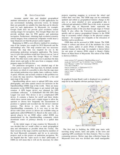
III.DATA COLLECTIONAccurate spatial data and detailed geographicalattribute information are the basis of LBS applications forany environment including university towns. In Irelandthere are generally no suitable free data that can be directlyused for such applications. In Maynooth, for example,Google Earth does not provide good resolution remotesensing images for navigation. Also Google Maps does notprovide attribute data for POI queries and pedestriannavigation. Furthermore, obtaining high resolution remotelysensed imagery from commercial companies would incur alarge financial cost that the project cannot support.Beginning in 2008 a cost effective method for creating amap of the campus was sought for NUI Maynooth and thesurroundings area. This map creation task was necessarybecause this map data was required for use in theprototyping pedestrian navigation application. The fastestway to solve this problem would have been to use an “out ofthe box” mapping system like Google Maps or VirtualEarth. The other more costly option was to purchase the dataabout streets and paths in this area from a company whichprepares maps for GPS devices.For pedestrian navigation a very detailed map of thecampus area is required. This map must, by default, includeall streets on which it is possible to drive but the map mustalso include pedestrian ways (paths, lanes, walkways, trails).A quick, efficient, and accurate solution to this problem wasto create the map ourselves. OpenStreetMap is a free andopen map of the world.OpenStreetMap allows users to upload GPS data, aerialphotography, and other spatial sources for inclusion on theOpenStreetMap (OSM) map of the world. There are manydocuments on the OSM Wiki pages to get started with mapcreation. A GPS logger device was obtained for GPScoordinate collection. A GlobalSat® DG-100 GPS DataLogger was used. This device is not a complicated GPSdevice. It contains a button for on/off and three diodeswhich show current status and a simple trigger to allow theoperator to choose how frequently the measurement ofposition is captured and recorded into the device's internalmemory. This device is very widely use by theOpenStreetMap community. It is very easy to use thisdevice with Linux servers as drivers are available using anapplication called GPSbabel [1]. Based on the same code, aspecial plug-in for an OSM editor called JOSM wasmanufactured by the OpenStreetMap community whichdownloads routes of journeys directly to a spatial dataeditor.At the initial stages of map creation for Maynooth, itwas decided that we would collect as much geographicaldata and information as possible about the vicinity. Thefinal versions of the maps could be used then by members ofthe local Maynooth community and for us in universityprojects such as this project on pedestrian navigation. Weare hopeful that the “open access to data” philosophy ofOSM [2] will mean that it will not be necessary for otherprojects requiring mapping to re-invent the wheel andcollect their own data. The OSM map can be continuallyupdated and edited as geographical features change in thearea or as more detailed or new geographical data iscollected and uploaded to OSM. Due to this work, at presentthe OSM map of Maynooth better represents thegeographical reality of the area than Google maps or VirtualEarth. It also offers the University the opportunity toquickly add or remove geographical features to the OSMmap to accurately reflect changes in the physical campusstructure – for example new footpaths or the relocation offacilities such as postboxes.OSM data can be accessed in XML format. The XMLformat is verbose and shows all of the attributes for a line(roads, streets, paths) or point (Point of Interest, shop,amenity) feature on the map. An example is shown belowfor one point of interest (POI) which is Brady's PublicHouse on Main Street of Maynooth. The subset of the XMLis shown as follows.In graphical format Brady's pub is displayed on a graphicalmap tile by the Mapnik software package (figure 2).Figure 2 data collection sampleThe first step in building the OSM map starts withtraveling along streets, lanes and paths, in the town andcapturing GPS coordinates for these features. This is a timeconsuming process. Before map data collection began theMaynooth town area was divided into small manageable20