CIICT 2009 Proceedings
CIICT 2009 Proceedings
CIICT 2009 Proceedings
- No tags were found...

Create successful ePaper yourself
Turn your PDF publications into a flip-book with our unique Google optimized e-Paper software.
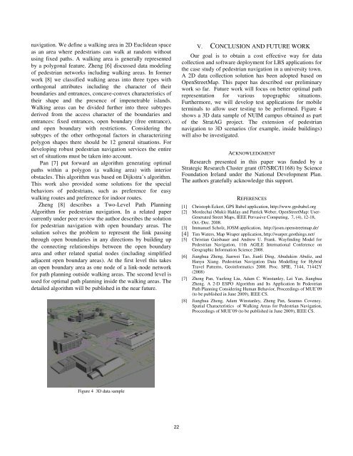
navigation. We define a walking area in 2D Euclidean spaceas an area where pedestrians can walk at random withoutusing fixed paths. A walking area is generally representedby a polygonal feature. Zheng [6] discussed data modelingof pedestrian networks including walking areas. In formerwork [8] we classified walking areas into three types withorthogonal attributes including the character of theirboundaries and entrances, concave-convex characteristics oftheir shape and the presence of impenetrable islands.Walking areas can be divided further into three subtypesderived from the access character of the boundaries andentrances: fixed entrances, open boundary (free entrance),and open boundary with restrictions. Considering thesubtypes of the other orthogonal factors in characterizingpolygon shapes there should be 12 general situations. Fordeveloping robust pedestrian navigation services the entireset of situations must be taken into account.Pan [7] put forward an algorithm generating optimalpaths within a polygon (a walking area) with interiorobstacles. This algorithm was based on Dijkstra’s algorithm.This work also provided some solutions for the specialbehaviors of pedestrians, such as preference for easywalking routes and preference for indoor routes.Zheng [8] describes a Two-Level Path PlanningAlgorithm for pedestrian navigation. In a related papercurrently under peer review the author describes the solutionfor pedestrian navigation with open boundary areas. Thesolution solves the problem to represent the link passingthrough open boundaries in any directions by building upthe connecting relationships between the open boundaryarea and other related spatial nodes (including simplifiedadjacent open boundary areas). At the first level this takesan open boundary area as one node of a link-node networkfor path planning outside walking areas. The second level isused for optimal path planning inside the walking areas. Thedetailed algorithm will be published in the near future.V. CONCLUSION AND FUTURE WORKOur goal is to obtain a cost effective way for datacollection and software deployment for LBS applications forthe case study of pedestrian navigation in a university town.A 2D data collection solution has been adopted based onOpenStreetMap. This paper has described our preliminarywork so far. Future work will focus on better optimal pathrepresentation for various topographic situations.Furthermore, we will develop test applications for mobileterminals to allow user testing to be performed. Figure 4shows a 3D data sample of NUIM campus obtained as partof the StratAG project. The extension of pedestriannavigation to 3D scenarios (for example, inside buildings)will also be investigated.ACKNOWLEDGMENTResearch presented in this paper was funded by aStrategic Research Cluster grant (07/SRC/I1168) by ScienceFoundation Ireland under the National Development Plan.The authors gratefully acknowledge this support.REFERENCES[1] Christoph Eckert, GPS Babel application, http://www.gpsbabel.org[2] Mordechai (Muki) Haklay and Patrick Weber, OpenStreetMap: User-Generated Street Maps, IEEE Pervasive Computing, 7, (4), 12-18,Oct.-Dec. 2008.[3] Immanuel Scholz, JOSM application, http://josm.openstreetmap.de/[4] Tim Waters, Map Wraper application, http://warper.geothings.net/[5] Christian Gaisbauer and Andrew U. Frank. Wayfinding Model forPedestrian Navigation, 11th AGILE International Conference onGeographic Information Science 2008.[6] Jianghua Zheng, Jianwei Tao, Jianli Ding, Abudukim Abuliz, andHanyu Xiang. Pedestrian Navigation Data Modelling for HybridTravel Patterns, Geoinformatics 2008. Proc. SPIE, 7144, 71442Y(2008)[7] Zheng Pan, Yuefeng Liu, Adam C. Winstanley, Lei Yan, JianghuaZheng. A 2-D ESPO Algorithm and Its Application In PedestrianPath Planning Considering Human Behavior, <strong>Proceedings</strong> of MUE’09(to be published in June <strong>2009</strong>), IEEE CS.[8] Jianghua Zheng, Adam Winstanley, Zheng Pan, Seamus Coveney.Spatial Characteristics of Walking Areas for Pedestrian Navigation,<strong>Proceedings</strong> of MUE’09 (to be published in June <strong>2009</strong>), IEEE CS.Figure 4 3D data sample22