

Technical Paper - HPD Around the World.pdf - Caris
Technical Paper - HPD Around the World.pdf - Caris
Technical Paper - HPD Around the World.pdf - Caris

You also want an ePaper? Increase the reach of your titles
YUMPU automatically turns print PDFs into web optimized ePapers that Google loves.
CARIS<br />
<strong>HPD</strong><br />
<strong>Around</strong> <strong>the</strong> <strong>World</strong><br />
For Release February 1, 2008 - Photo 3<br />
CARIS Welcomes Delegation from MSA for <strong>HPD</strong> Training<br />
CARIS, a leading developer of geomatics<br />
software, hosted sixteen delegates<br />
from <strong>the</strong> China Maritime Safety<br />
Administration (MSA) at its global<br />
headquarters in Canada for two intensive<br />
weeks of training on CARIS<br />
Hydrographic Production Database<br />
(<strong>HPD</strong>) in January.<br />
The training is part of a sale made by<br />
CARIS to MSA in late 2007. The purchase<br />
includes 112 licenses of CARIS<br />
<strong>HPD</strong> Source Editor, <strong>Paper</strong> Chart Editor<br />
and ENC Editor as well as seven<br />
CARIS, a leading developer of geomatics<br />
software, is pleased to announce it has<br />
been awarded a contract by <strong>the</strong> Service<br />
Hydrographique et Océanographique de<br />
la Marine (SHOM) to deliver a Marine<br />
Spatial Data Infrastructure (MSDI) to<br />
access its hydrographic information.<br />
CherSoft as a subcontractor will supply a<br />
tide database as part of <strong>the</strong> solution.<br />
weeks of training. The balance of <strong>the</strong><br />
training will be hosted at MSA facilities<br />
at a later date.<br />
<strong>HPD</strong> will be implemented at all three<br />
MSA regional hydrographical centres<br />
in Tianjin, Guangzhou and Shanghai,<br />
which undertake <strong>the</strong> surveying and<br />
charting of <strong>the</strong> Bohai Sea, Yellow Sea,<br />
East China Sea and South China Sea<br />
respectively.<br />
This initial training covered <strong>the</strong> set-up,<br />
system administration and management<br />
For Release March 31, 2008 - Photo 4<br />
CARIS Marine Spatial Data Infrastructure Solution for France<br />
CARIS<br />
115 Waggoners Lane<br />
Fredericton, New Brunswick<br />
E3B 2L4 Canada<br />
Tel +1.506.458.8533<br />
Fax +1.506.459.3849<br />
info@caris.com<br />
CARIS BV<br />
Mgr. van Oorschotstraat 13<br />
PO Box 47 5473 ZG<br />
Heeswijk, The Ne<strong>the</strong>rlands<br />
Tel +31.413.296010<br />
Fax +31.413.296012<br />
info@caris.nl<br />
The launch of <strong>the</strong> project occurred in<br />
mid-February for a week, with focused<br />
meetings on project strategy and benefits.<br />
Through this contract, referred<br />
to as INFRAGEOS-H (Infrastructure<br />
Géospatiale du SHOM for Hydrographic<br />
data), CARIS will deliver a<br />
technological infrastructure built on<br />
CARIS bathymetric and hydrographic<br />
CARIS USA<br />
415 N Alfred Street<br />
Alexandria VA 22314<br />
United States<br />
Tel +1.703.299.9712<br />
Fax +1.703.299.9715<br />
carisusa@caris.com<br />
CARIS software and <strong>the</strong> CARIS logo are registered trademarks of CARIS. O<strong>the</strong>r brands and product names are registered<br />
trademarks or trademarks of <strong>the</strong>ir respective holders. ©2008 CARIS. All rights reserved.<br />
CARIS Asia Pacific<br />
Suite 1, Innovation House<br />
Mawson Lakes Boulevard<br />
Mawson Lakes SA 5095<br />
Australia<br />
Tel +61.0.8.8260.8180<br />
Fax +61.0.8.8260.8100<br />
info@caris.com<br />
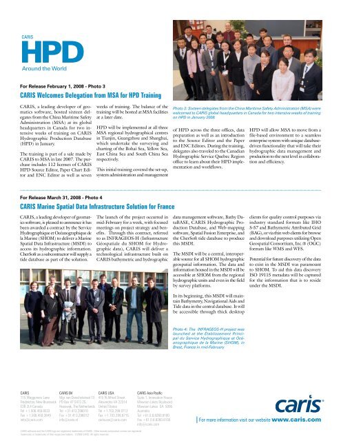
Photo 3: Sixteen delegates from <strong>the</strong> China Maritime Safety Administration (MSA) were<br />
welcomed to CARIS global headquarters in Canada for two intensive weeks of training<br />
on <strong>HPD</strong> in January 2008.<br />
of <strong>HPD</strong> across <strong>the</strong> three offices, data<br />
preparation as well as an introduction<br />
to <strong>the</strong> Source Editor and <strong>the</strong> <strong>Paper</strong><br />
and ENC Editors. During <strong>the</strong> training,<br />
delegates also traveled to <strong>the</strong> Canadian<br />
Hydrographic Service Quebec Region<br />
office to learn about <strong>the</strong>ir <strong>HPD</strong> implementation<br />
and workflows.<br />
data management software, Bathy DataBASE,<br />
CARIS Hydrographic Production<br />
Database, and Web-mapping<br />
software, Spatial Fusion Enterprise, and<br />
<strong>the</strong> CherSoft tide database to produce<br />
this MSDI.<br />
The MSDI will be a central, interoperable<br />
source for all SHOM hydrographic<br />
geospatial information. The data and<br />
information housed in <strong>the</strong> MSDI will be<br />
accessible at SHOM from <strong>the</strong> regional<br />
hydrographic units and even in <strong>the</strong> field<br />
by survey platforms.<br />
In its beginning, this MSDI will maintain<br />
Bathymetry, Navigational Aids and<br />
Tide data in <strong>the</strong> central database. It will<br />
be accessible through thick desktop<br />
Photo 4: The INFRAGEOS-H project was<br />
launched at <strong>the</strong> Établissement Principal<br />
du Service Hydrographique et Océanographique<br />
de la Marine (SHOM), in<br />
Brest, France in mid-February<br />
<strong>HPD</strong> will allow MSA to move from a<br />
file-based environment to a seamless<br />
enterprise system with unique databasedriven<br />
functionality that will take <strong>the</strong>ir<br />
hydrographic data management and<br />
production to <strong>the</strong> next level in collaboration<br />
and efficiency.<br />
clients for quality control purposes via<br />
industry standard formats like IHO<br />
S-57 and Bathymetric Attributed Grid<br />
(BAG), or via thin web clients for browse<br />
and download purposes utilizing Open<br />
Geospatial Consortium, Inc.® (OGC)<br />
formats like WMS and WFS.<br />
Potential for future discovery of <strong>the</strong> data<br />
to exist in <strong>the</strong> MSDI was paramount<br />
to SHOM. To aid this data discovery<br />
ISO 19115 metadata will be captured<br />
for <strong>the</strong> information that is to reside<br />
under <strong>the</strong> MSDI.<br />
For more information visit our website www.caris.com


