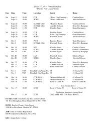
Currituck County Planning Board Meeting on November 13, 2012 ...
Currituck County Planning Board Meeting on November 13, 2012 ...
Currituck County Planning Board Meeting on November 13, 2012 ...

Create successful ePaper yourself
Turn your PDF publications into a flip-book with our unique Google optimized e-Paper software.
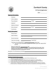
CASE ANALYSIS FOR THE<str<strong>on</strong>g>Planning</str<strong>on</strong>g> <str<strong>on</strong>g>Board</str<strong>on</strong>g>DATE: <strong>November</strong> <strong>13</strong>, <strong>2012</strong>PB 12-10 East Point EstatesITEM: PB 12-10 East Point Estates, Preliminary Plat/Special Use Permit for a 22-lot subdivisi<strong>on</strong>.LOCATION:TAX ID:ZONING DISTRICT:PRESENT USE:OWNER:APPLICANT:Knotts Island: 172 Marsh Causeway, Fruitville Township.0046-000-003B-0000RR (Residential Recreati<strong>on</strong>al)Campground<str<strong>on</strong>g>Currituck</str<strong>on</strong>g> 34, LLC500 Central Drive, Suite 106Virginia Beach, VA 23464Clayt<strong>on</strong> E. Massey, PEBowman C<strong>on</strong>sulting1561 Bradford Road, Suite 202Virginia Beach, VA 23455LAND USE/ZONING OF SURROUNDING PROPERTY:Land UseZ<strong>on</strong>ingNORTH: Mobile Home Park/Campground RRSOUTH Low density residential/Farmland AEAST: Low density residential/Mining/Farmland AWEST: North Landing River N/ALAND USE PLANCLASSIFICATION:SIZE OF SITE:NUMBER OF UNITS:PROJECT DENSITY:OPEN SPACE:UTILITIES:The 2006 Land Use Plan classifies the site as Limited Service Areawithin the Knotts Island and Gibbs Woods subarea.32.955 acres22 Residential Lots.67 units per acre6.59 acres required open space (20% of total development).7.151 acres open space provided including 20,000 square foot ofwater access.The individual lots will be served by private wells and <strong>on</strong>-site septicsystems.PB 12-10 East Point EstatesPreliminary PlatPage 1 of 10
I. NARRATIVE OF REQUEST:1. <str<strong>on</strong>g>Currituck</str<strong>on</strong>g> 34, LLC is requesting preliminary plat/special use permit approval of a 22 lotresidential subdivisi<strong>on</strong> with an overall project density of .67 units per acre.2. The proposed development includes a 20,000 square foot water access. However, thearea provided is linear in shape which may reduce the overall access potential. Access isprovided to an existing boat ramp.3. The sketch plan was approved October 12, <strong>2012</strong>.II. QUESTION(S) BEFORE THE BOARD:Special Use Permit Criteria and Staff Findings:Special use permits (SUP) are intended to allow the <str<strong>on</strong>g>Board</str<strong>on</strong>g> of Commissi<strong>on</strong>ers flexibility in theadministrati<strong>on</strong> of the UDO. Through the SUP procedure, property uses which would otherwisebe c<strong>on</strong>sidered undesirable in certain districts can be developed subject to c<strong>on</strong>diti<strong>on</strong>s ofapproval to minimize any negative effects they might have <strong>on</strong> surrounding properties.In order to approve a SUP, certain criteria must be satisfied. The criteria and suggestedfindings of fact are outlined as follows:1. Completeness of applicati<strong>on</strong>.Suggested Findings:a. The applicati<strong>on</strong> is complete.2. The proposed use is am<strong>on</strong>g those listed in the Table of Permissible Uses as a special useindicated with an “S”.Suggested Findings:a. Chapter 10 of the UDO allows a major subdivisi<strong>on</strong> as a permissible use with a specialuse permit.3. The c<strong>on</strong>diti<strong>on</strong>s proposed meet or exceed the minimum requirements of this ordinance.Suggested Findings:a. As presented, the subdivisi<strong>on</strong> meets or exceeds the minimum requirements of theordinance.4. The special use will not endanger the public health or safety:Suggested Findings:a. The subdivisi<strong>on</strong>s should have little to no impact <strong>on</strong> public health or safety.5. The special use will not injure the value of adjoining or abutting property and will be inharm<strong>on</strong>y with the area in which it is locatedSuggested Findings:a. The UDO indicates that a subdivisi<strong>on</strong> is allowed in the RR z<strong>on</strong>ing district with a specialuse permit.b. The proposed residential subdivisi<strong>on</strong> shall harm<strong>on</strong>ize well with the surroundingcommunity.PB 12-10 East Point EstatesPreliminary PlatPage 2 of 10
6. The special use will be in c<strong>on</strong>formity with the Land Use Plan or other officially adoptedplan.Suggested Findings:The 2006 Land Use Plan classifies this site as Limited Services within the Knotts Island andGibbs Woods subarea. The Limited Services area is to provide for primarily residentialdevelopment at low densities. Base density should be <strong>on</strong>e unit per acre but could beincreased to 1.5 units per acre through overlay z<strong>on</strong>ing depending up<strong>on</strong> whether servicefacilities are in placed or planned <strong>on</strong> the surrounding community. The policy emphasis forthe developable areas of Knotts Island is to remain as low to very low density residentialareas; predominantly 1 unit per 3 acres. The proposed use is in keeping with the policiesof the plan, some of which are:POLICY HN1: <str<strong>on</strong>g>Currituck</str<strong>on</strong>g> <str<strong>on</strong>g>County</str<strong>on</strong>g> shall encourage development to occur at densitiesappropriate for the locati<strong>on</strong>. LOCATION AND DENSITY FACTORS shall include whether thedevelopment is within an envir<strong>on</strong>mentally suitable area, the type and capacity of sewagetreatment available to the site, the adequacy of transportati<strong>on</strong> facilities providing access tothe site, and the proximity of the site to existing and planned urban services. For example,projects falling within the Full Services areas of the Future Land Use Map would bepermitted a higher density because of the availability of infrastructure as well as similarityto the existing development pattern. Such projects could be developed at a density of two(2) or more dwelling units per acre. Projects within areas designated as Limited Servicewould be permitted a density of <strong>on</strong>e (1) to <strong>on</strong>e and <strong>on</strong>e half (1.5) units per acre dependingup<strong>on</strong> the surrounding development pattern and availability of resources. Projects withinareas designated as Rural or C<strong>on</strong>servati<strong>on</strong> by the Future Land Use Plan would be permitteda much lower density of 1 dwelling unit per 3 acres because of the lack of infrastructure inthe area, the existing low density development pattern, and presence of envir<strong>on</strong>mentallysensitive natural areas.POLICY KI1: The need for ACCESS TO PUBLIC TRUST WATERS in the Knotts Island area shallbe met through periodic improvements to existing public facilities. The <str<strong>on</strong>g>County</str<strong>on</strong>g> alsorecognizes that private sector facilities may play a role in satisfying access needs to thewater.7. The special use will not exceed the county's ability to provide adequate public facilities,including, but not limited to, schools, fire and rescue, law enforcement, and other countyfacilities. Applicable state standards and guidelines shall be followed for determiningwhen public facilities are adequate. Such facilities must be in place or programmed to bein place within two years after the initial approval of the plan (sketch plan in the case ofmajor subdivisi<strong>on</strong>s).Suggested Findings:a. The proposed 22 lot residential subdivisi<strong>on</strong> will not exceed the county’s ability toprovide adequate public facilities.III. TECHNICAL REVIEW COMMITTEE RECOMMENDATION:Pursuant to the Unified Development Ordinance, the Technical Review Committee recommendsapproval subject to the following plan correcti<strong>on</strong>s:PB 12-10 East Point EstatesPreliminary PlatPage 3 of 10
<str<strong>on</strong>g>Planning</str<strong>on</strong>g>:1. A signed copy of the US Army Corps of Engineer’s wetland delineati<strong>on</strong> and jurisdicti<strong>on</strong>aldeterminati<strong>on</strong> shall be provided that is c<strong>on</strong>sistent with the preliminary determinati<strong>on</strong>.2. Three full size copies of the revised open space calculati<strong>on</strong>s must be provided.3. The road names must be provided and approved.4. A hardsurfaced, ADA accessible trail system may be provided in the 22 lot residentialsubdivisi<strong>on</strong> in lieu of sidewalks <strong>on</strong> both sides of the proposed streets.NC State Archaeology:5. A Phase I Cultural Resources Survey was completed by Circa- Cultural ResourceManagement, LLC in June, <strong>2012</strong>. Due to the sites high probability for potentiallysignificant archaeological resources, the OSA is recommending that the project approvalsinclude the following c<strong>on</strong>diti<strong>on</strong>s:1. Prior to initiati<strong>on</strong> of any ground disturbing activities within the project area, thepermittee shall arrange for an archaeological survey and assessment of the entireproject area. The purpose of the survey will be to locate archaeological sites withinthe project area and to determine if they are significant in terms of the Nati<strong>on</strong>alRegister of Historic Places.2. If a significant site is located within the project area the permittee shall determinewhether the site will be adversely affected by the project activities; and, if so,develop and implement an appropriate mitigati<strong>on</strong> plan. Two copies of all resultingarchaeological reports, as well as <strong>on</strong>e copy of the North Carolina site forms, should beforwarded to the Office of State Archaeology for review and comment as so<strong>on</strong> asthey are available and in advance of any c<strong>on</strong>structi<strong>on</strong> or ground disturbance activities.A list of archaeological c<strong>on</strong>sultants who have c<strong>on</strong>ducted or expressed an interest inc<strong>on</strong>tract work in North Carolina is available at www.arch.dcr.state.nc.us/c<strong>on</strong>sults.htm.The archaeologists listed, or any other experienced archaeologist, may be c<strong>on</strong>tactedto c<strong>on</strong>duct the recommended survey. All activities associated with the archaeologicalinvestigati<strong>on</strong>s shall be coordinated with the Office of State Archaeology prior tobeginning any archaeological fieldwork.PB 12-10 East Point EstatesPreliminary PlatPage 4 of 10
PB 12-10 East Point EstatesPreliminary PlatPage 5 of 10
PB 12-10 East Point EstatesPreliminary PlatPage 6 of 10
1. The area at the p<strong>on</strong>d for the fire apparatus must be 20 feet wide and should take themeasurements located in appendix d of the fire code.2. Need to see the calculati<strong>on</strong>s used for the fire p<strong>on</strong>d capacity. This should be in a sealedformat. More detail is needed in regards to dimensi<strong>on</strong>s of the dry hydrant.3. It appears that <strong>on</strong>e cul-de-sac is less than 96 feet in diameter.<str<strong>on</strong>g>Currituck</str<strong>on</strong>g> <str<strong>on</strong>g>County</str<strong>on</strong>g> Code Enforcement, Stacey Smith 252-232-6027No comment<str<strong>on</strong>g>Currituck</str<strong>on</strong>g> <str<strong>on</strong>g>County</str<strong>on</strong>g> Building Inspecti<strong>on</strong>s, Spence Castello 252-232-6020Approved<str<strong>on</strong>g>Currituck</str<strong>on</strong>g> <str<strong>on</strong>g>County</str<strong>on</strong>g> Parks and Recreati<strong>on</strong>, Jas<strong>on</strong> Weeks 252-232-3007No commentNC Divisi<strong>on</strong> of Coastal Management, Charlan OwensReviewed1. Review of proposed land disturbance and development activities suggests that a CAMAMajor Permit may be required. Please c<strong>on</strong>tact R<strong>on</strong> Renaldi at 264-3901 to discuss theproject.NC State Archaeology, Lawrence AbbotReviewed1. The project area is located <strong>on</strong> a tract of land overlooking the North Landing River. Otherarchaeological sites are located in the general vicinity of the project area in a similarsetting. The project tract is c<strong>on</strong>sidered a high probability area for potentially significantarchaeological resources. As a result, we recommend that the project approvals includethe following c<strong>on</strong>diti<strong>on</strong>s:a. Prior to initiati<strong>on</strong> of any ground disturbing activities within the project area, thepermittee shall arrange for an archaeological survey and assessment of the entireproject area. The purpose of the survey will be to locate archaeological siteswithin the project area and to determine if they are significant in terms of theNati<strong>on</strong>al Register of Historic Places.b. If a significant site is located within the project area the permittee shall determinewhether the site will be adversely affected by the project activities; and, if so,develop and implement an appropriate mitigati<strong>on</strong> plan. Two copies of all resultingarchaeological reports, as well as <strong>on</strong>e copy of the North Carolina site forms,should be forwarded to the Office of State Archaeology for review and commentas so<strong>on</strong> as they are available and in advance of any c<strong>on</strong>structi<strong>on</strong> or grounddisturbance activities.A list of archaeological c<strong>on</strong>sultants who have c<strong>on</strong>ducted or expressed an interest inc<strong>on</strong>tract work in North Carolina is available at www.arch.dcr.state.nc.us/c<strong>on</strong>sults.htm.The archaeologists listed, or any other experienced archaeologist, may be c<strong>on</strong>tactedto c<strong>on</strong>duct the recommended survey. All activities associated with the archaeologicalinvestigati<strong>on</strong>s shall be coordinated with the Office of State Archaeology prior tobeginning any archaeological fieldwork.Albemarle Regi<strong>on</strong>al Health Services, Joe Hobbs 252-232-6603PB 12-10 East Point EstatesPreliminary PlatPage 9 of 10
Reviewed1. Please c<strong>on</strong>sult with Kevin Carver, RS at 252-232-6603 c<strong>on</strong>cerning septic system andprivate well approval for each lot that will make up this proposed subdivisi<strong>on</strong>.US Army Corps of Engineers, Kyle Barnes 910-251-4584Reviewed1. Any impacts to jurisdicti<strong>on</strong>al waters or wetlands of the US require prior approval from theUS Army Corps of Engineers.The following items are necessary for resubmittal:• 3 - full size copies of revised plans.• 10 - 11”x17” copies of revised plans.• 1- 8.5”x11” copy of all revised plans.• 1- PDF digital copy of all revised documents and plans.PB 12-10 East Point EstatesPreliminary PlatPage 10 of 10