Landuse - Calaveras County Government Services
Landuse - Calaveras County Government Services
Landuse - Calaveras County Government Services

You also want an ePaper? Increase the reach of your titles
YUMPU automatically turns print PDFs into web optimized ePapers that Google loves.
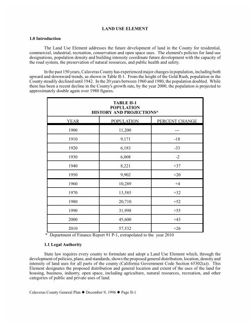
LAND USE ELEMENT1.0 IntroductionThe Land Use Element addresses the future development of land in the <strong>County</strong> for residential,commercial, industrial, recreation, conservation and open space uses. The element's policies for land usedesignations, population density and building intensity coordinate future development with the capacity ofthe road system, the preservation of natural resources, and public health and safety.In the past 150 years, <strong>Calaveras</strong> <strong>County</strong> has experienced major changes in population, including bothupward and downward trends, as shown in Table II-1. From the height of the Gold Rush, population in the<strong>County</strong> steadily declined until 1942. In the 20 years between 1960 and 1980, the population doubled. Whilethere has been a recent decline in the <strong>County</strong>'s growth rate, by the year 2000, the population is projected toapproximately double again over 1980 figures.TABLE II-1POPULATIONHISTORY AND PROJECTIONS*YEAR POPULATION PERCENT CHANGE1900 11,200 ---1910 9,171 -181920 6,183 -331930 6,008 -21940 8,221 +371950 9,902 +201960 10,289 +41970 13,585 +321980 20,710 +521990 31,998 +552000 45,600 +432010 57,532 +26* Department of Finance Report 91 P-1, extrapolated to the year 20101.1 Legal AuthorityState law requires every county to formulate and adopt a Land Use Element which, through thedevelopment of policies, plans, and standards, shows the proposed general distribution, location, density andintensity of land uses for all parts of the county (California <strong>Government</strong> Code Section 65302(a)). ThisElement designates the proposed distribution and general location and extent of the uses of the land forhousing, business, industry, open space, including agriculture, natural resources, recreation, and othercategories of public and private uses of land.<strong>Calaveras</strong> <strong>County</strong> General Plan z December 9, 1996 z Page II-1
Insert Future Land Use Plan Map<strong>Calaveras</strong> <strong>County</strong> General Plan z December 9, 1996 z Page II-3
TABLE II-2NATURAL RESOURCE/COMMUNITY DEVELOPMENT DISTRIBUTIONLAND USE ACREAGE TOTALS PERCENTAGENATURAL RESOURCE LAND 361,740 54.98Wildlife, BotanicalTimber, Dam Area, MRA-2AAgriculture Preserve, MRA-2B72,540143,630122,45023,11011.0221.8318.613.51COMMUNITY DEVELOPMENT LAND 284,230 43.20Future Single Family> 50% SlopeCommunity CentersResidential CentersIndustrial*Existing ZoningPrime IndustrialAdopted Community PlansAdopted Special PlansAdopted Specific Plans184,12010,9403,60031,1408,2009,48028,34025,0001,09028.011.660.544.864.303.790.17CITY OF ANGELS AND ITS SPHERE 11,950 1.82TOTAL COUNTY 657,9201.4 Determining Maximum DensitiesThe General Plan utilizes "density" rather than "minimum parcel size." Lower density results inlarge minimum parcel size.Parcels may in some instances possess two or more differing specifications on a parcel of land. Topreserve the Plan's internal consistency, the more restrictive (lower density or large minimum parcel size)requirements apply. For example, a parcel of land may be identified as a protected wildlife habitat with 40acre density, but may also be identified in a timber area with a 20 acre density. The land use would bedesignated as wildlife habitat and the 40 acre density established to protect wildlife habitat would apply.The <strong>County</strong> has adopted density bonus provisions to conform to <strong>Government</strong> Code Section 65915,which is discussed in the Housing Element.1.5 Development FlexibilityFlexibility in the design and provision of public facilities and services for new development in the<strong>County</strong> is essential for many developers. Flexibility often produces a better project design than would becreated by adhering to rigid standards. Allowing developers to construct or contribute to the improvementof public facilities and services may enable development to proceed which might otherwise be delayed oreven stopped because public facilities and services are not available at acceptable levels.<strong>Calaveras</strong> <strong>County</strong> General Plan z December 9, 1996 z Page II-4
GENERAL PLAN RECOMMENDATIONSGoal II-4:Maintain Community Plans for areas of the <strong>County</strong> in which major growth is occurring.Policy II-4A: Maintain and reinforce Community Plan areas as the sites which may permit highdensity single family residential, multiple family residential, commercial, light industrial, andcommunity activities, in addition to Special and Specific Plans Areas, Mixed Use/Master ProjectAreas, and Community Centers.Implementation Measure II-4A-1: Future high density single family residential, multiplefamily residential, commercial, and light industrial developments and zoning may be locatedwithin Community Plan areas.Implementation Measure II-4A-2: The following densities apply to the adopted CommunityPlans:Arnold Community Plan:[Refer to Land Use Element Appendix]Mokelumne Hill Community Plan:[Refer to Land Use Element Appendix]Murphys-Douglas Flat Community Plan:[Refer to Land Use Element Appendix]San Andreas Community Plan:[Refer to Land Use Element Appendix]Valley Springs Community Plan:[Refer to Land Use Element Appendix]Policy II-4B: Consider creation of Community Plans for major community areas without an adoptedCommunity Plan, and consider use of assessment districts to pay for the development of such plans.Implementation Measure II-4B-1: When requested by a representative group of residents,consider new Community Plan areas for regions generally meeting the following criteria:• Population base of 1000 or more;• An area logically tied together geographically and socially.Policy II-4C: Keep Community Plans current and consistent with local issues and communityvalues, and the General Plan.Implementation Measure II-4C-1: Review and update Community Plans as needed,consistent with state law and amendment procedures contained in the Plans.<strong>Calaveras</strong> <strong>County</strong> General Plan z December 9, 1996 z Page II-7
Policy II-4D: Review proposals for development in Community Plan areas for potential trafficimpacts.Implementation Measure II-4D-1: Utilize the criteria in the Circulation Element to mitigatetraffic impacts of all new development in Community Plan areas.Policy II-4E: Consider and balance the impacts of resource production and community developmentuses within Community Plan areas.Implementation Measure II-4E-1: Review applications for resource production zoning andassociated use permits within Community Plan areas for compatibility with adjacent landuses and policies of the Community Plan.3.2 Special Plan Areas (CGC Section 65302)Special Plans are a part of the General Plan, although contained in a separate published booklet.They are intended to serve areas possessing architectural or historic characteristics, scenic resources, orspecial use. Special Plans are utilized primarily by larger subdivisions, scenic highway corridors, and areasof the <strong>County</strong> which share a common bond. The <strong>County</strong> has adopted the Ebbetts Pass Highway Special Plan,the Rancho <strong>Calaveras</strong> Special Plan, and the <strong>County</strong> Airport Special Plan.Special Plans contain a greater level of specificity regarding permitted land uses than are establishedin the General Plan with respect to land use policies, consistent zoning, and issues of local concern. In thisregard, the more specific Special Plan policies supplement and refine the policies of the General Plan. Whena Special Plan does not address an issue that is covered in the General Plan, the policies of the General Planapply.GENERAL PLAN RECOMMENDATIONSGoal II-5: Maintain Special Plans for areas of the <strong>County</strong> possessing unique resource or development issues.Policy II-5A: Maintain and reinforce Special Plan areas as sites with unique resource ordevelopment issues, but which can include high density single family residential, multiple familyresidential, commercial, light industrial, and community activities, in addition to Community andSpecific Plans Areas, Mixed Use/Master Project Areas, and Community Centers.Implementation Measure II-5A-1: While future high density single family residential,multiple family residential, commercial, and light industrial developments and zoning maybe located within Special Plan areas, it is not required.Implementation Measure II-5A-2: The following densities apply to the adopted SpecialPlans:Airport Special Plan:[Refer to Land Use Element Appendix]<strong>Calaveras</strong> <strong>County</strong> General Plan z December 9, 1996 z Page II-8
Ebbetts Pass Highway Special Plan:[Refer to Land Use Element Appendix]Rancho <strong>Calaveras</strong> Special Plan:[Refer to Land Use Element Appendix]Policy II-5B: Consider creation of Special Plans as appropriate to address unique areas or issues,and consider use of assessment districts to pay for the development of such plans.Implementation Measure II-5B-1: When requested by a representative group of residents,consider new Special Plans for areas meeting the following criteria:• There is general consensus that specific issues need to be addressed; or• There are unique scenic, historic, or architectural characteristics; or• There is a service, issue, or requirement of the area which needs to be addressed inmore detail than found in the General Plan.Policy II-5C: Keep Special Plans current and consistent with Special Plan issues and values, and theGeneral Plan.Implementation Measure II-5C-1: Review and update Special Plans as needed, consistentwith state law and amendment procedures contained in the Plans.Policy II-5D: Review proposals for development in Special Plan areas for potential traffic impact.Implementation Measure II-5D-1: Utilize the criteria in the Circulation Element and <strong>County</strong>Road Ordinance, Chapter 12.02 of <strong>County</strong> Code, to mitigate traffic impacts of all newdevelopment in Special Plan areas.Policy II-5E: Consider and balance the impacts of resource production and community developmentuses within Special Plan areas.Implementation Measure II-5E-1: Review applications for resource production zoning andassociated use permits within Special Plan areas for compatibility with adjacent land usesand policies of the Special Plan.3.3 Specific Plan Areas (CGC Section 65454)A Specific Plan is an implementation tool for the General Plan established for a specified area withmultiple land uses, and is contained in a separate published booklet. The purpose of a Specific Plan is toprovide a long term comprehensive development plan for an area consistent with the broader provisions ofthe General Plan. Specific Plan adoption is generally initiated at the request of an individual projectproponent or small group of property owners. The <strong>County</strong> has adopted two specific plans, the <strong>Calaveras</strong>Country Club Specific Plan (Saddle Creek) and the Spring Valley Estates Specific Plan.<strong>Calaveras</strong> <strong>County</strong> General Plan z December 9, 1996 z Page II-9
The contents of a Specific Plan are governed by both <strong>County</strong> policy and State law (<strong>Government</strong> Codesection 65450 et seq.). When a Specific Plan addresses an issue more specifically than the General Plan, therelevant policies of the Specific Plan supplement and refine the policies of the General Plan.GENERAL PLAN RECOMMENDATIONSGoal II-6: Provide long term, comprehensive development planning for large projects involving multipleland uses.Policy II-6A: Maintain and reinforce Specific Plan areas as the sites which may permit high densitysingle family residential, multiple family residential, commercial, light industrial, and communityactivities, in addition to Community and Special Plans Areas, Mixed Use/Master Project Areas, andCommunity Centers.Implementation Measure II-6A-1: Future high density single family residential, multiplefamily residential, commercial, and light industrial developments and zoning may be locatedwithin Specific Plan areas.Implementation Measure II-6A-2: The following densities apply to the adopted SpecificPlans:<strong>Calaveras</strong> Country Club Specific Plan (Saddle Creek):[Refer to Land Use Element Appendix]Spring Valley Estates Specific Plan:[Refer to Land Use Element Appendix]Policy II-6B: Encourage the use of Specific Plans for large projects with multiple land uses.Implementation Measure II-6B-1: Utilize Specific Plans for proposed projects meeting thefollowing criteria:• An area with multiple land use development;• The project for which the Specific Plan is proposed is to be developed over a periodof at least three years;Policy II-6C: Promote policies governing Specific Plan usage contained in State law.Implementation Measure II-6C-1: Allow proponents of Specific Plans to recover costs ofplanned development and environmental review through a fee structure contained in theadopted Specific Plan.Implementation Measure II-6C-2: Permit amendments to Specific Plans consistent withstate law and amendment procedures contained in the Plans.Policy II-6D: Consider and balance the impacts of resource production and community developmentuses within Specific Plan areas.<strong>Calaveras</strong> <strong>County</strong> General Plan z December 9, 1996 z Page II-10
Implementation Measure II-6D-1: Review applications for resource production zoning andassociated use permits within Community Centers for compatibility with adjacent land usesand policies of the Specific Plan.3.4 City of Angels Sphere of InfluenceThe Angels Sphere of Influence represents the ultimate potential incorporated territory of the Cityof Angels for which land use classifications, consistent zoning districts, and development policies areincluded in the City's General Plan. While the <strong>County</strong> has legal jurisdiction over the unincorporated sphereof influence, General Plan policies contemplate that the processing of subdivisions, rezoning and use permitsin this area will be coordinated with city policies and recommendations. Changes to the <strong>County</strong> General Planrelating to the Angels Sphere of Influence require corresponding changes to the City's General Plan.The City's land use map for its sphere of influence (See Sphere of Influence map Page II-12) isincorporated into the <strong>County</strong> General Plan. Table II-3 shows the population densities, building intensitiesand consistent zones for the Angels Sphere of Influence.GENERAL PLAN RECOMMENDATIONSGoal II-7: Provide comprehensive, coordinated planning for the Angels Sphere of Influence.Policy II-7A: Forward all projects to be considered by the <strong>County</strong> located within the Angels Sphereof Influence to the City for review and comment.Policy II-7B: Incorporate any changes to the Angels Sphere of Influence, its land use map,designations into the <strong>County</strong> General Plan.Policy II-7C: Encourage concurrent application to the City when General Plan amendments to theAngels Sphere of Influence are submitted to the <strong>County</strong>.Implementation Measure II-7C-1: Review applications for General Plan amendments to theAngels Sphere of Influence in light of the City's recommendation on the application.Implementation Measure II-7C-2: The following densities apply to the City of AngelsSphere of Influence:<strong>Calaveras</strong> <strong>County</strong> General Plan z December 9, 1996 z Page II-11
Sphere of Influence map<strong>Calaveras</strong> <strong>County</strong> General Plan z December 9, 1996 z Page II-12
TABLE II-3CITY OF ANGELS SPHERE OF INFLUENCELAND USE DESIGNATIONPublic <strong>Services</strong>CONSISTENTZONESPOPULATIONDENSITYBUILDINGINTENSITYResidential SuburbanNo matter which servicesA1RA0.130.2620.005.00Low Density ResidentialPublic water, septic orWell water and septicMedium Density ResidentialPublic water and sewerPublic water and septicWell water and septicAgriculture EstatessewerRRRA, RR-5R1-7200R1, RRRR-5A12.560.2615.362.560.260.131.005.000.161.005.0020.00IndustrialPublic ServiceMiningCommercial-RecreationM1, M2, M4PSMEREC, RCSame as Community CentersSame as Industrial combining zoneSame as CommercialSpecial Planning: Special or Specific Plan required prior to zoning.The Rural Home Industry zone is consistent with RR, RA, A1, AP, TP. Resource zones (A1, AP, GF,TP, ME) are consistent in all designations.The PS zone is consistent in all designations.3.5 Mixed Use/Master Project AreaHistorically, development projects in <strong>Calaveras</strong> <strong>County</strong> have involved single land uses on relativelysmall tracts of land. The Mixed Use/Master Project Area land use designation offers the opportunity for amore comprehensive land use planning approach.Instead of having smaller tracts of land with single uses, this General Plan designation allows a mixof uses to be located throughout a large site, enhancing the overall quality of the development.Infrastructure and recreational amenities can be coordinated to provide maximum benefits. Inaddition, complex infrastructure and public facility issues posed by mixed use developments on large sitesare subject to further, more detailed review as part of a Specific Plan or similar planning process requiredof all projects in this designation.The Mixed Use/Master Project Area General Plan designation is intended for large scale projectswith integrated mixed uses, including single and multiple family housing, commercial uses, and recreationand open space uses. Mixed Use/Master Project Areas must have direct frontage or<strong>Calaveras</strong> <strong>County</strong> General Plan z December 9, 1996 z Page II-13
other suitable access onto one of the <strong>County</strong>'s four state highways, and be serviceable by sewer and waterinfrastructure. It is also understood that projects of this type will develop in phases extending over a periodof 5 to 20 years.Residential Uses.The majority of the development within this land use category would be single family residential.Actual determinations of maximum allowable density would be consistent with the standards set forth in theGeneral Plan. Clustering of units may be suitable to enhance the preservation of open space.Nonresidential Uses.The Mixed Use/Master Project Area designation allows for a broad range of nonresidential uses,including commercial uses typically found in neighborhood and community areas, such as retail and serviceestablishments, office and financial uses, and light industrial uses. Other nonresidential uses includeprivately operated commercial recreation areas, such as golf courses and equestrian facilities. Resourceproduction uses are also compatible with the Mixed Use/Master Project Area designation.GENERAL PLAN RECOMMENDATIONSGoal II-8: Provide for the integration of residential and nonresidential uses within large developments.Policy II-8A: When large tracts of land are proposed for development, encourage an integratedmix of uses and a master planned infrastructure.Implementation Measure II-8A-1: Apply the Mixed Use/ Master Project Areadesignation to projects meeting the following criteria:• State highway frontage or other suitable state highway access;• Proximate to existing sewer and water infrastructure;• Includes both residential and nonresidential uses;• Phased development over approximately 5 to 20 years.Implementation Measure II-8A-2: Require a Specific Plan or suitable equivalentplanning process for allprojects within the Mixed Use/Master Project Area designation.Implementation Measure II-8A-3: Utilize criteria set forth in the General Plan todetermine maximum density allowed within Mixed Use/Master Project Areas.3.6 Community CentersThe Community Center designation is assigned to the smaller towns for which Community, Specialor Specific Plans have not been prepared. The areas designated Community Centers on the General PlanFuture Land Use Map tend to follow the boundaries of the <strong>County</strong>'s original townsites<strong>Calaveras</strong> <strong>County</strong> General Plan z December 9, 1996 z Page II-14
or early subdivision maps. In addition to Community, Special, and Specific Plan areas, Community Centerstend to be centers of regional life in the <strong>County</strong>. The following Community Centers are designated in theGeneral Plan: Avery, Burson, Camp Tamarack, Carson Hill, Copper Cove/Poker Flat, Copperopolis,Glencoe, La Contenta, Mountain Ranch, Rail Road Flat, Sheep Ranch, Vallecito, Wallace, and West Point.Public facilities and services are generally available within Community Centers, allowing the moreintensive land usage generated by multi-family, commercial and light industrial uses. Public facilities andservices within Community Centers generally include adequate roads, water supply, sewage disposal, andthe availability of fire protection services. Road capacity and the capability of roads to handle developmentare addressed in Community Centers on a project-specific basis using the policies and requirementscontained in the Circulation Element and <strong>County</strong> Road Ordinance.GENERAL PLAN RECOMMENDATIONSGoal II-9: Provide for orderly development within Community Center boundaries.Policy II-9A: Maintain and reinforce Community Centers as the sites which may permit highdensity single family residential, multiple family residential, commercial, light industrial, andcommunity activities, in addition to Community, Special and Specific Plans Areas, and MixedUse/Master Project Areas.Implementation Measure II-9A-1: Future high density single family residential, multiplefamily residential, commercial, and light industrial developments and zoning may be locatedwithin Community Centers.Implementation Measure II-9A-2: Utilize the following percentages of land area to land useas a guide for planning within the Community Center:Single family residential - 60%Multifamily residential - 10%Commercial/light industrial - 15%Open space - 15%Policy II-9B: Review development in Community Centers to ensure proposed intensity or densitydoes not exceed the capacity of available facilities and services.Implementation Measure II-9B-1: Consider a maximum density of 6 units per acre for singlefamily residential and 12 units per acre for multiple family residential development onparcels served by public water and sewer systems.Implementation Measure II-9B-2: Consider a maximum density of one unit per acre forsingle family residential and six units per acre for multiple family residential developmenton parcels served by a public water system and a private septic system conforming with thepolicies of the Safety Element.Policy II-9C: Review proposed development within Community Centers for traffic impacts.<strong>Calaveras</strong> <strong>County</strong> General Plan z December 9, 1996 z Page II-15
Implementation Measure II-9C-1: Apply the project specific criteria of the CirculationElement and <strong>County</strong> Road Ordinance, Chapter 12.02 of <strong>County</strong> Code, to all newdevelopment and subdivision activity within Community Centers.Implementation Measure II-9C-2: Consider requests for zone changes to multiple familyresidential, commercial or light industrial zones on parcels which do not derive access froma through or connector road only when all of the following criteria are met:• The proponent has submitted a preliminary plan prepared to the specifications ofthe Planning Director to provide for access and public facilities and services; and• The proponent has posted improvement security satisfactory to the <strong>County</strong> to coverthe cost of any necessary improvements based on the approved preliminary plan.Policy II-9D: Consider and balance the impacts of resource production and community developmentuses within Community Centers.Implementation Measure II-9D-1: Review applications for resource production zoning andassociated usepermits within Community Centers for compatibility with adjacent land uses.Goal II-10: Discourage strip commercial development from occurring within Community Centers.Policy II-10A: Encourage clustering in the siting of new multiple family residential, commercial,and industrial land uses in Community Centers.Implementation Measure II-10A-1: Allow cluster development when appropriate in lightof existing and proposed land uses.Goal II-11:Maintain appropriate Community Center boundaries.Policy II-11A: Consider appropriate increases in territory receiving the Community Centerdesignation.Implementation Measure II-11A-1: Review applications for expansion of CommunityCenters in light of the following criteria:• The proposal is accompanied by a specific project application; and• The area to be added to an existing Community Center is contiguous and forms alogical boundary; and• The proposed land use and zoning are consistent with all Community Centerpolicies.Implementation Measure II-11A-2: Consider applications for new Community Centers inlight of the following criteria :<strong>Calaveras</strong> <strong>County</strong> General Plan z December 9, 1996 z Page II-16
• The area is centered around and includes an existing townsite or residential subdivision;and• The area has existing multiple family residential, commercial, and/or lightindustrial land uses; and• The area is within a fire protection district; and• The area is served by a public water system.3.7 Residential CentersBecause of their concentrated population and available public facilities and services, CommunityCenters may influence adjoining lands to be subdivided into residential areas. To encourage orderlydevelopment in these areas, the General Plan designates "Residential Centers" around Community Centers.As the <strong>County</strong> grows, portions of Residential Centers may become logical extensions of Community Centers.GENERAL PLAN RECOMMENDATIONSGoal II-12: Designate Residential Center areas to provide for orderly residential development.Policy II-12A: Establish and expand Residential Center boundaries as appropriate to include logical,contiguous area suitable for residential development.Implementation Measure II-12A-1: Utilize Residential Centers around Community Centersto indicate areas best suited for single family residential development using the followingcriteria:• The area is located within a fire protection district or public water district;• The area is located within one-half mile of a minor arterial or major collector road;• The area is socially and geographically tied to the nearest Community Center.Policy II-12B: Review proposed development in Residential Centers for impacts on facilities andservices.Implementation Measure II-12B-1: Allow a maximum density of one dwelling unit per 40acres within the Sheep Ranch Residential Center, and implement zoning consistent with thatdensity.Implementation Measure II-12B-2: Allow the following maximum densities whenconsidering subdivision applications within all other Residential Centers:• One dwelling unit per five acres for parcels with domestic water wells and individualseptic systems;• One dwelling unit per acre for parcels with public water supply and individualseptic systems;• One dwelling unit per one-half acre for parcels with public water supply and publicsewage disposal.<strong>Calaveras</strong> <strong>County</strong> General Plan z December 9, 1996 z Page II-17
Policy II-12C: Review proposed development within Residential Centers for traffic impacts.Implementation Measure II-12C-1: Apply the project specific criteria of the CirculationElement and <strong>County</strong> Road Ordinance, Chapter 12.02 of <strong>County</strong> Code, to all newdevelopment and subdivision activity within Residential Centers.Policy II-12D: Consider and balance the impacts of resource production and communitydevelopment uses within Residential Centers.Implementation Measure II-12D-1: Review applications for resource production zoning andassociated use permits within Residential Centers for compatibility with adjacent land uses.3.8 Single Family Residential AreasSingle family residential areas are used primarily for single-family dwellings, although they may alsobe used for secondary non-residential purposes. Residential areas in the <strong>County</strong> are located within towns,residential subdivisions, and rural settlements.Most towns in the <strong>County</strong> are located in Community Centers and Community or Special Plan areas.Rural settlements are found in areas of the <strong>County</strong> presently subdivided into parcels of 5 to 40 acres in size.Approximately one-half of the privately owned parcels of land in the <strong>County</strong> are unimproved. Themajority of those unimproved parcels are designated for single-family residential and range in size up to 40acres.Allowable density on future single-family residential lands outside of Community Centers,Residential Centers, and Community, Special or Specific Plan areas is governed by a number of factorsincluding the level of service on roads serving the area, domestic water supply, available sewage disposalmethods, fire protection services, school district capacity, and topography.GENERAL PLAN RECOMMENDATIONSGoal II-13: Ensure that future single-family residential land divisions or increased density occur on landscapable of supporting such land use.Policy II-13A: Determine appropriate densities and parcel sizes based on land capability, level ofservice of <strong>County</strong> access roads, availability of potable water, sewage disposal methods, slopecharacteristics, public facilities and services, and public safety considerations.Implementation Measure II-13A-1: Allow newly created single-family residential landdivisions of less than 40 acres or an increased density of more than one house per forty acresprovided <strong>County</strong> roads providing access to the land have a service level of A, B or C.Implementation Measure II-13A-2: Allow newly created subdivision of five or more lotsof forty acres or larger, provided <strong>County</strong> roads providing access to the land have a servicelevel of A, B, or C.<strong>Calaveras</strong> <strong>County</strong> General Plan z December 9, 1996 z Page II-18
Implementation Measure II-13A-3: Apply the following criteria to determine densitieshigher than one dwelling per five acres:• Within Community Centers:Parcels served by public water and public sewer: one dwelling per 7,000 squarefeet;Parcels served by public water and conventional septic: one dwelling per 1 acre;Parcels served by individual well and conventional septic: one dwelling per 5acres.• Within Residential Centers:Parcels served by public water and public sewer: one dwelling per one-half acre;Parcels served by public water and conventional septic: one dwelling per 1 acre;Parcels served by individual well and conventional septic: one dwelling per 5acres.• Within Community Plan areas, Special Plan areas, or Specific Plan areas:Refer to the adopted Plan document for parcel size determination.• Outside Community Plan, Special Plan, Specific Plan, Community Centers,Residential Centers, or Mixed Use/Master Project Areas: one dwelling per fiveacres.Policy II-13B: Review proposed residential development for traffic impacts.Implementation Measure II-13B-1: Apply the project specific criteria of the CirculationElement and <strong>County</strong> Road Ordinance, Chapter 12.02 of <strong>County</strong> Code, to all new residentialdevelopment and subdivision activity.Policy II-13C: Review proposed residential development for impacts on natural resource lands.Implementation Measure II-13C-1: Consider on a case-by-case basis the impacts ofproposed residential development on natural resource lands.Goal II-14: Achieve consistency between land use designations and zoning.Policy II-14A: Permit resource production zones for agriculture, timber, and mining on landsdesignated future single-family residential when compatible with adjoining land uses and zoning.Implementation Measure II-14A-1: Rezone all lands presently within interim zones toconform to General Plan policies.<strong>Calaveras</strong> <strong>County</strong> General Plan z December 9, 1996 z Page II-19
Goal II-15: Protect the reasonable use of property in the <strong>County</strong>.Policy II-15A: Allow the construction of one single-family residence on each legally created parcelcapable of supporting such use.4.0 Industrial AreasImplementation Measure II-15A-1: Permit the construction of a single-family residence oneach legally created parcel in the <strong>County</strong> when:• Such use is permitted in the zoning district applied to the parcel;• The parcel has a source of potable domestic water satisfying <strong>County</strong> requirements;• The parcel has an approved method of sewage disposal;• No known health or safety hazards exist on the parcel.Industrial areas are those areas designated principally for processing, fabrication, or manufacturingof goods and commodities.Existing Industrial Lands are those currently in operation or currently zoned light industrial (M1),general industrial (M2), rural home industry (RM), or business park (M4). Existing industrial landsprovide major sources for employment in <strong>Calaveras</strong> <strong>County</strong>. Mining and timber are the largest industrialuses in <strong>Calaveras</strong> <strong>County</strong>. Many lands with industrial zoning are former or current mining sites. Before1978 when the <strong>County</strong> added provisions to its Zoning Code specifically to address mineral extraction inagricultural areas, industrial zoning was applied to mining sites. These industrial zones are still recognized.Future Industrial designations and zoning are to be located within Community Centers,Community, Special and Specific Plan areas, Mixed Use/Master Project Areas, or the Industrial Corridor(See Section 4.1). Efforts by the <strong>Calaveras</strong> <strong>County</strong> Economic Development Company continue to assist inbringing new industries into the <strong>County</strong>. While the major industrial attraction to <strong>Calaveras</strong> <strong>County</strong> remainsaccess to raw materials, technological developments, affordable real estate, and anavailable work force make <strong>Calaveras</strong> <strong>County</strong> increasingly attractive to non-resource industries.GENERAL PLAN RECOMMENDATIONSGoal II-16: Enable existing industries to maintain and expand their operations in the <strong>County</strong>.Policy II-16A: Retain existing industrially zoned lands, unless the property owner requestsotherwise.Implementation Measure II-16A-1: Recognize legally established existing industrial zonesas a consistent zone within the Community Development/Future Single Family Residentialand Natural Resource Designations.Goal II-17: Provide for new industrial development in areas designated by the General Plan which allowindustrial designations.<strong>Calaveras</strong> <strong>County</strong> General Plan z December 9, 1996 z Page II-20
Policy II-17A: Allow the Industrial designation and zoning in Community, Special and Specific Planareas, Mixed Use/Master Project area, Community Centers, and the Industrial Corridor.Implementation Measure II-17A-1: Consider requests for industrial zoning, consistent withthe policies as defined in the land use categories of the General Plan and individual plans.Implementation Measure II-17A-2: Use all of the following criteria for siting lightindustrial uses and zoning in Community Centers:• The subject property has direct access to a minor arterial or major collector; and• The subject property is served by public water and sewer, or has proposed sourcesof water and sewage disposal approved by the <strong>County</strong> Department of EnvironmentalHealth; and• Development of the subject property for industrial use is compatible withneighboring land uses and zoning; and• The requested zoning is M1, RM, or M4.Policy II-17B: Review proposed industrial development for traffic impacts.Implementation Measure II-17B-1: Apply the project specific criteria of the CirculationElement and <strong>County</strong> Road Ordinance, Chapter 12.02 of <strong>County</strong> Code, to all new industrialdevelopment and subdivision activity.4.1 Industrial CorridorA corridor paralleling Highway 12 between San Andreas and the San Joaquin <strong>County</strong> line has beenestablished as the area of the <strong>County</strong> where major industrial development is generally encouraged to locate.This corridor is called the Industrial Corridor, and establishes a Policy Boundary within which the Industrialdesignation and new industrial zoning may be permitted.The lands within this Industrial Corridor are generally level, have access to State Highway 12 and,in many locations, are served by public water, fire protection services, natural gas, and good electrical powerdistribution. The Industrial Corridor includes a mix of land uses, and, due to the significant acreage withinthe corridor, it is not the intent of the General Plan that the entire corridor should be designated, rezoned anddeveloped into industrial uses. There are numerous areas withinthe Industrial Corridor presently developed as rural settlements, planned subdivisions, Community Centersand Community Plan areas.While land in the Industrial Corridor has the potential to accommodate industrial zoning districts,siting of future uses and zoning within the Corridor must be compatible with other types of existing andpotential development in the general vicinity. In addition, additional lands within the corridor, based upona Specific or Special Plan, may be planned for supporting residential and commercial uses.<strong>Calaveras</strong> <strong>County</strong> General Plan z December 9, 1996 z Page II-21
Road capacity and the capability of roads to handle development will be addressed in the IndustrialCorridor using the policies and requirements contained in the Circulation Element and <strong>County</strong> RoadOrdinance.GENERAL PLAN RECOMMENDATIONSGoal II-18: Provide for industrial development to occur within the Industrial Corridor.Policy II-18A: Give priority to industrial land uses on appropriate parcels within the IndustrialCorridor.Implementation Measure II-18A-1: Lands with existing industrial zoning within the corridorshall be designated as Industrial, unless located within a Community Plan Area, Special PlanArea, Specific Plan Area, Mixed Use/Master Project Area, or Community Center.Implementation Measure II-18A-2: Review the existing land uses within the boundaries ofthe Industrial Corridor and revise the boundaries of the Industrial Corridor to exclude thoseareas that have already been developed or approved for residential use.Policy II-18B: Review lands within the Industrial Corridor for new industrial zoning based oncompatibility with surrounding land uses, access, noise impacts, level of service, and availability ofpublic facilities and services.Implementation Measure II-18B-1: Review the existing land uses within the vicinity of theIndustrial Corridor, identify acreage suitable for future planned development to includeindustrial uses and potential industrial parks, and preserve those designated areas within anIndustrial Corridor Special Plan Area, and also amend the policy boundary accordingly.Implementation Measure II-18B-2: Review and identify other areas of the <strong>County</strong> suitablefor industrial uses, and amend the plan to appropriately designate the lands.Implementation Measure II-18B-3: Require a general plan amendment for a Special Plan,Specific Plan, or industrial designation when approving new industrial zoning.Implementation Measure II-18B-4: Consider applications for zone changes to M1, M2, orM4 on parcels in the Industrial Corridor meeting all of the following criteria:• The parcel size can meet the development criteria with respect to adequate waterand sewer facilities;• Compatibility with the surrounding land uses can be demonstrated;Implementation Measure II-18B-5: Apply criteria of the Circulation Element and <strong>County</strong>Road Ordinance, Chapter 12.02 of <strong>County</strong> Code, to all new development activity within theIndustrial Corridor.<strong>Calaveras</strong> <strong>County</strong> General Plan z December 9, 1996 z Page II-22
4.2 Rural Home IndustriesThe rural home industry zone provides a basis for small scale industry that is larger than a RuralHome Business in terms of employees, traffic generation, and operations, yet small enough to be compatiblewith a rural residential lifestyle. A key factor separating a Rural Home Industry from a traditional industrialuse is that the owner resides on the same property as the business. A Rural Home Industry is a secondaryuse to the primary residential use of the parcel. The business must also be compatible with residential useson adjoining parcels.GENERAL PLAN RECOMMENDATIONSGoal II-19: Appropriately provide for Rural Home Industries as accessory uses to residences.Policy II-19A: Require conditional use permits for all Rural Home Industries, and consider permitapplications on a case-by-case basis, using established criteria.Policy II-19B: In the review of applications for Rural Home Industries, the existence of anotherRural Home Industry in the general vicinity is not to be considered precedent on which to approvenew applications.Implementation Measure II-19B-1: Consider applications for Rural Home Industries on acase-by-case basis utilizing all of the following criteria:• The subject property is five acres or larger;• The proposed Rural Home Industry does not have the potential to become anuisance;• The business owner resides on the subject property on a full-time, permanent basis;• The subject property has frontage and access onto a state highway or any publicroad meeting county road improvement standards for its functional serviceclassification;• The road serving the subject property is either publicly maintained or included ina special district or mandatory maintenance association;• The proposed Rural Home Industry complies with all county, state and federal lawsrelating to health and safety.5.0 Recreation Oriented CommercialThe abundance of natural recreation resources in <strong>Calaveras</strong> <strong>County</strong> gives rise to commercial usesproviding support facilities to recreation areas. Examples include campgrounds, boat rentals and storage,marine fuel stations, and ski area facilities. Because the location of recreation resources is governed largelyby natural features such as caves, lakes and rivers, associated commercial development is appropriate in theseareas. The General Plan addresses this special circumstance in the policies which follow.Location-specific recreation uses are distinguishable from general commercial uses which serve, butare not directly tied to particular recreation resources. Examples of recreation oriented businesses which arenot directly linked to the location of recreation resources include sporting goods stores and restaurants whosepatrons include visitors to distant recreation areas. It is the intent of<strong>Calaveras</strong> <strong>County</strong> General Plan z December 9, 1996 z Page II-23
the General Plan to accommodate the location of commercial development which is truly tied to a specificrecreation resource, as opposed to all recreation oriented businesses.GENERAL PLAN RECOMMENDATIONSGoal II-20: Provide for the development of recreation oriented commercial uses which are necessarily tiedto the location of recreation resources.Policy II-20A: Allow location-specific recreation-oriented commercial uses outside of Community,Special, and Specific Plan areas, and Community Centers.Implementation Measure II-20A-1: Identify locations in the <strong>County</strong> possessing naturalfeatures appropriate for associated recreation oriented commercial development.Implementation Measure II-20A-2: Utilize the Recreation Zone of the <strong>County</strong> Zoning Codeto promote General Plan objectives regarding recreation oriented commercial uses.Policy II-20B: Encourage master planned recreation developments to enhance the long term use anddevelopment of recreation resources.Implementation Measure II-20B-1: Utilize the Recreation Zone of the <strong>County</strong> Zoning Codeto provide for planned recreation developments.Policy II-20C: Review proposed recreation oriented commercial uses for traffic impacts.Implementation Measure II-20C-1: Require project-specific improvements prescribed in theCirculation Element and <strong>County</strong> Road Ordinance, Chapter 12.02 of <strong>County</strong> Code, tomitigate potential road impacts upon development of these parcels.<strong>Calaveras</strong> <strong>County</strong> General Plan z December 9, 1996 z Page II-24
TABLE II-4POPULATION DENSITY J BUILDING INTENSITYCONSISTENT ZONES_ (For explanation, see notes following the charts)NATURAL RESOURCE LANDSLand Use Classifications Consistent Zones 1 Maximum Density 2Levels of Service 3 A, B, or C are required for parcels under 40 acresWildlife, BotanicalA1-40, GF-40AP-50TP-16040 acres50 acres160 acresAgriculture Preserves A1-20AP-5020 acres 450 acresTimberlandsA1-20, GF-20AP-50TP-16020 acres50 acres160 acresDam Inundation A1-20-EP 20 acresMineral Resource 2AMineral Resource 2BRA-5A1-20, GF-20AP-50TP-160RA-5RA-10A1-20, GF-20AP-50TP-1605 acres 520 acres50 acres160 acres5 acres 510 acres20 acres50 acres160 acres1 - CONSISTENT ZONE - Indicates the smallest consistent zone, or most intence consistent zonepermitted in the land use designation.2 - MAXIMUM DENSITY - The number of dwelling units per acre based on the land usedesignation in the General Plan.3 - LEVEL OF SERVICE: As assigned in the Special Provisions to the Road Ordinance, or as setby other criteria. See Circulation Element Table III-1 for explanation.4 - The 20 acre density is an automatic holding density which is applicable when a Williamson Actcontract expires.5 - Five acre parcels are possible in MRA lands with findings consistent with the ConservationElement.<strong>Calaveras</strong> <strong>County</strong> General Plan z December 9, 1996 z Page II-25
COMMUNITY DEVELOPMENT LANDSCommunity CentersA. Residential Areas1. Single-Family ResidentialLevel of Service Water, Sewer 6 Consistent Zones Maximum DensityA, B, or C Public, publicPublic, septicWell, septicD, E, or F Public, publicPublic, septicWell, septicR1R1-1, RR-1RR-5, RA-5RR-40, RA-40RR-40, RA-40RR-40, RA-407,000 sq. ft.1 acre5 acres40 acres40 acres40 acres2. Multi-Family ResidentialA, B, or C Public, publicPublic, publicPublic, septicPublic, septicWell, septicWell, septicR2-7000R3-3500R2-1R3-1R2-5R3-53,500 sq. ft.3,500 sq. ft.20,000 sq. ft.7,000 sq. ft.2.50 acres1.67 acresD, E, or F New multiple family residential not permittedB. Commercial, Industrial, Public Service Areas1. CommercialLevel of Service Water, Sewer Consistent Zones Maximum Density(Lot Coverage) 7A, B, or C Public, publicPublic, septicWell, septicRC, C1, C2, CPRC, C1, C2, CPRC, C1, C2, CP100 %, less setback &landscaping requirements100 %, less setback, septic &landscaping requirements100 %, less setback, septic &landscaping requirementsD, E, or F New Commercial or Industrial not permitted<strong>Calaveras</strong> <strong>County</strong> General Plan z December 9, 1996 z Page II-26
A, B, or C Public, publicPublic, septicWell, septic2. Light IndustrialM1, RM, M4M1, RM, M4M1, RM, M4100 %, less setback &landscaping requirements100 %, less setback, septic &landscaping requirements100 %, less setback, septic &landscaping requirementsD, E, or F New Industrial zones not permittedAny level of Service Any Service PS, ME No requirementsC. Resource ZonesA, B, or C Any Service A1, GF 20 acresD, E, or F Any Service A1-40, GF-40 40 acresAny level of Service Any Service TP-160AP-50160 acres50 acres6 - WATER and SEWAGE: Public - provided by special district; Well - individual private well orsmall water system; Septic - individual private conventional septic system.7 - LOT COVERAGE - minimum parcel sizes are not established in commercial or industrial zones.Lot coverage is assigned based on the availability of water or method of sewage disposal, parcel sizes arepreferred at no less than one acre with public water, and no less than five acres with well and septic, unlesssmaller parcels are approved by the Department of Environmental Health.Residential CentersA. Residential Areas1. Single-Family ResidentialLevel of Service Water, Sewer Consistent Zones Maximum DensityA, B, C Public, publicPublic, septicWell, septicD, E, F Public, publicPublic, septicWell, septicR1-20000, RR-20000R1-1, RR-1RR-5, RA-5RR-40, RA-40RR-40, RA-40RR-40, RA-400.5 acres1 acre5 acres40 acres40 acres40 acres<strong>Calaveras</strong> <strong>County</strong> General Plan z December 9, 1996 z Page II-27
Future Single Family Residential1. Single-Family ResidentialLevel of Service Water, Sewer Consistent Zones Maximum DensityA, B, C Public, publicPublic, septicWell, septicD, E, F Public, publicPublic, septicWell, septicRR-5, RA-5RR-5, RA-5RR-5, RA-5RR-40, RA-40RR-40, RA-40RR-40, RA-405 acres5 acres5 acres40 acres40 acres40 acres2. Single-Family Residential with 50 % or greater slopesA, B, C Any Service RR-20, RA-20, A1 20 acresD, E, F Any Service RR-40, RA-40, A1-4040 acresIndustrial CorridorThe Industrial Corridor establishes a policy boundary within whichthe Industrial designation may be permitted. This section applies topotential industrial zones.Level of Service Water, Sewer Consistent Zones Maximum DensityA, B, C Public, publicPublic, septicWell, septicM1, M2, M4, RMM1, M2, M4, RMM1, M2, M4, RM100 %, less setback &landscaping requirements100 %, less setback, septic &landscaping requirements100%, less setback, septic &landscaping requirementsD, E, F Industrial uses not permittedRecreationally-oriented CommercialA. Direct recreationally-oriented commercial usesLevel of Service Water, Sewer Consistent Zones Maximum DensityAll levelsPublic, publicPublic, septicWell, septicRECRECREC35 %35 %35 %B. Indirect recreationally-oriented commercial uses shall be located where consistent with commercialuses and zoning.<strong>Calaveras</strong> <strong>County</strong> General Plan z December 9, 1996 z Page II-28
City of Angels Sphere of InfluenceSee Table II-3, Page II-11In the event of amendments between the City's General Plan designations for its Sphere of Influenceand the designations shown in the <strong>County</strong> General Plan, the City's designation shall take precedence untilthe <strong>County</strong>'s amendment process is complete. The intent is that the <strong>County</strong>'s designations within the AngelsSphere of Influence be consistent with the City's General Plan for the area.Community, Special, & Specific PlansSee Tables in Land Use Element AppendixSee the applicable Community Plan for areas designated as Community Plan Areas on the FutureLand Use Map ( Arnold, Mokelumne Hill, Murphy-Douglas Flat, San Andreas, and Valley Springs). ForSpecial Plans, see the Rancho <strong>Calaveras</strong> Ebbetts Pass Highway or the <strong>Calaveras</strong> <strong>County</strong> Airport plans. ForSpecific Plans, see Saddle Creek (previously <strong>Calaveras</strong> <strong>County</strong> Club) or Spring Valley Estates._ IMPORTANT NOTES / EXPLANATIONSThe following items have a direct bearing on the determination of population density and buildingintensity.&&&&&&&&&To determine population density, multiply the number of dwellings per acre by the persons per dwellingfor the area.Minimum parcel size per dwelling or number of dwellings per maximum density mean the same numberof dwelling units per acre.When multiple land use designations apply, the most restrictive land use takes precedence.Legally existing non conforming residential parcels may be zoned RR-X, if less than 5 acres, and RA-Xif between 5 and 20 acres no matter which Natural Resource Lands classification that property is locatedwithin.Lands in the Industrial Corridor which may have a base General Plan designation within NaturalResource Lands are still eligible to be considered for M1, M2, and M4 zoning if otherwise consistentwith the policies of this element related to the Corridor.Resource zones (A1, AP, GF, TP, RA) are consistent in any land use designation.The PS (Public Service) zone is consistent in all designations.The REC (Recreation) zone may be consistent in any Natural Resource Lands classification, providedthat the development proposed concurrently with the rezoning request isconsistent with the policies ofthis element.The RM (Rural Home Industry) zone is consistent with the RR, RA, A1, AP, GF, and TP zones.<strong>Calaveras</strong> <strong>County</strong> General Plan z December 9, 1996 z Page II-29
TABLE II-4 (continued)REFERENCE TABLE OF ZONING DISTRICTSU UNCLASSIFIED InterimHS HIGHWAY SERVICE InterimA1 GENERAL AGRICULTURE ResourceAP AGRICULTURE PRESERVE ResourceGF GENERAL FOREST ResourceTP TIMBER PRODUCTION ResourceRA RESIDENTIAL AGRICULTURE ResourceRR RURAL RESIDENTIAL ResidentialR1 SINGLE FAMILY RESIDENTIAL ResidentialR2 TWO FAMILY RESIDENTIAL ResidentialR3 MULTIPLE FAMILY ResidentialRC RURAL COMMERCIAL CommercialRM RURAL HOME INDUSTRY Home BusinessC1 NEIGHBORHOOD COMMERCIAL CommercialC2 GENERAL COMMERCIAL CommercialCP PROFESSIONAL OFFICES CommercialM1 LIGHT INDUSTRY IndustrialM2 GENERAL INDUSTRY IndustrialM4 BUSINESS PARK IndustrialREC RECREATION RecreationPS PUBLIC SERVICE Miscellaneous6.0 Businesses in the HomeA significant number of the business licenses issued each year in <strong>Calaveras</strong> <strong>County</strong> are for businessesin the home. The <strong>County</strong> Zoning Code recognized several types of home businesses, and provides standardsto ensure compatibility between home business activity and the character of the surrounding neighborhood.All home businesses must be secondary to residential property uses. Business activity of greater intensitythan the Zoning Code allows for home businesses may be appropriately located in the Rural Home Industryor other commercial or industrial zone.Residential Occupations are suited for residential areas with predominately small parcels. They aretypically service oriented businesses or offices which do not require customer or client traffic to the home,rarely require a sign, generally cause no change to the exterior appearance of the home, and do not generatetraffic above normal levels for single family residences.Rural Home Businesses are suited for larger parcels typically found in rural and resource areas, whichpermit greater latitude in the operation of a business in the home. Larger parcel sizes provide a bufferbetween neighboring residences, reducing the potential for nuisances to arise. The greater the separationbetween a rural home business and an adjacent residence, the less likelihood of incompatibility.<strong>Calaveras</strong> <strong>County</strong> General Plan z December 9, 1996 z Page II-30
Home Medical and Veterinary Clinics provide a means of bringing medical and veterinary servicesto rural areas of the <strong>County</strong> not otherwise served by those professionals.GENERAL PLAN RECOMMENDATIONSGoal II-21: Support economic growth and development in the <strong>County</strong> by providing for businesses in thehome, in addition to regular commercial and industrial development.Policy II-21A: Review proposed businesses in the home for subservience to residential use andcompatibility with neighboring uses.Implementation Measure II-21A-1: Utilize the <strong>County</strong> Zoning Code to impose standards forbusinesses in the home based on factors including parcel size, hours of operation, noise,odor, dust, traffic, waste disposal, and outdoor storage needs.Implementation Measure II-21A-2: Utilize the <strong>County</strong> Zoning Code to impose standards forthe appropriate siting of rural home medical and veterinary clinics.7.0 Legally Existing Nonconforming Land Uses and ZoningSome commercial, industrial and multi-family residential development is located in areas of the <strong>County</strong>which today would not accommodate those uses or zones. These long standing businesses and apartmentspredate the current General Plan, and in some cases predate the Zoning Ordinance.Similarly, there exist undeveloped parcels which obtained legal commercial, industrial or multi-familyresidential zoning under different standards than those in effect today. Nonconformance may also applyto parcel sizes. For example, smaller parcels of land may exist than what is now called for in the GeneralPlan. Those parcels may have been legally created under a previous Plan, the provisions of the SubdivisionMap Act or prior law regulating the division of land, or may not have been subject to regulation at the timeof their creation.With the adoption of the 1982 <strong>County</strong> General Plan, the Board of Supervisors recognized these legallyestablished uses and zones. It is the intent of the Board of Supervisors to continue to allow the use anddevelopment of legally existing noncon-forming uses, zoning and parcels."Nonconforming" refers to a land use or parcel size which does not conform to present General Planpolicies. "Legally existing" means that the use, zoning or parcel was legallyestablished under regulations in effect at the time it was first commenced or created.When legally existing nonconforming uses or zones are sited in areas where new commercial, industrialor multi-family development would not now be permitted, the "grandfathered" uses and zoning are exemptedfrom requirements relating to functional service classifications and levels of service for roads on which theyare located. Legally existing nonconforming uses are not exempt, however, from project-specificimprovements required under the Circulation Element and Road Ordinance. Whenever an undevelopedparcel with legally existing nonconforming zoning develops the specific impacts of the project must bemitigated.<strong>Calaveras</strong> <strong>County</strong> General Plan z December 9, 1996 z Page II-31
GENERAL PLAN RECOMMENDATIONSGoal II-22: Continue to assure that all existing legally established parcels, uses and zoning retain their legalstatus.Policy II-22A: Recognize as legally existing the uses, parcels and zoning which do not conform tocurrent standards but which were legally established under the regulations in effect at the time they werefirst commenced or created.Implementation Measure II-22A-1: Notwithstanding the land uses and densities prescribedby this General Plan or any ordinances enacted pursuant thereto, including any zoningordinances or their amendments, any parcel or unit of land which has been previouslycreated under the provisions of the Subdivision Map Act or any prior law regulating thedivision of lands or a local ordinance enacted pursuant thereto or was not subject to thoseprovisions at the time of its creation, including any parcel or unit of land at the time legallycreated by deed or record of survey, shall not:be deemed to be an illegal parcel or unit of land or be denied issuance of acertificate of compliance or a conditional certificate ofcompliance under the provisions of the Subdivision Map Act.be required to merge with any other contiguous parcel(s) or unit(s) of land whetheror not said other parcel(s) or unit(s) are held by the same owner.be denied the issuance of any permit or approval to develop the real property witha single-family residential structure, unless a specific written comment is made bya <strong>County</strong> public health or safety department that development of the affected parcelor unit of land would constitute a hazard to the public health or the public safety.Implementation Measure II-22A-2: Any land use legally established under provisions of theregulations in effect at the time of establishment, shall be allowed to continue such useunder the provisions of a nonconforming use in the zoning code.Implementation Measure II-22A-3: Any commercial, industrial, or multifamily zoninglegally existing within areas which under this General Plan would not be permitted, shallbe considered consistent zoning within the designation.Policy II-22B: Deem all uses and parcels not established in conformance with the General Plan orregulations in effect at the time the use or parcel was established or created, which prohibit said use orcreation, to be illegal nonconforming uses and parcels, and prohibit their development, continued useor expansion.Implementation Measure II-22B-1: Apply the provisions of the <strong>County</strong> Zoning Coderelating to non-conforming uses and parcels.Policy II-22C: For parcels having only a portion of their total area within a legally existingnonconforming zoning district, apply recognized legally existing nonconforming zoning to those<strong>Calaveras</strong> <strong>County</strong> General Plan z December 9, 1996 z Page II-32
portions only and not to the entire parcel or to any other parcel under common ownership outside thenonconforming zoning district.Implementation Measure II-22C-1: When expansion of legally existing nonconforming usesis proposed, require the property owner to meet the development requirements of the zoningdistrict at the time of the proposed expansion.Policy II-22D: Review proposed expansion or development of legally existing nonconforming uses fortraffic impacts.8.0 SchoolsImplementation Measure II-22D-1: When legally existing nonconforming uses expand, oran undeveloped parcel with legally existing nonconforming zoning is to be developed,require project-specific improvements meeting the provisions of the Circulation Element and<strong>County</strong> Road Ordinance, Chapter 12.02 of <strong>County</strong> Code.The administrative body of the school system in <strong>Calaveras</strong> <strong>County</strong> is the <strong>County</strong> Board of Education.The school system includes four school districts: <strong>Calaveras</strong> Unified, Vallecito Union Elementary, MarkTwain Union Elementary, and Bret Harte Union High. The districts operate ten elementary schools and fourhigh schools.<strong>Calaveras</strong> <strong>County</strong> is included in two community college districts: Yosemite and San Joaquin Delta. TheYosemite District has one campus in Modesto and another in Columbia. The San Joaquin Delta District hasa campus in Stockton plus a college farm near Manteca. It also operates a natural habitat reserve nearMountain Ranch.New residential land development can significantly impact the capacity of school systems.DISTRICTS AND SCHOOLS<strong>Calaveras</strong> UnifiedJenny LindMokelumne HillRailroad FlatSan AndreasToyon MiddleValley SpringsWest Point<strong>Calaveras</strong> HighGoldstrike High (Continuation)Crossroads (Educationally Handicapped)Vallecito UnionMichelsonHazel FischerAvery Middle SchoolMark Twain UnionCopperopolisMark TwainBret Harte UnionArnold HighBret Harte HighVallecito High (Continuation)<strong>Calaveras</strong> <strong>County</strong> General Plan z December 9, 1996 z Page II-33
GENERAL PLAN RECOMMENDATIONSGoal II-23:Strive to provide the highest quality of education facilities for all ages of <strong>County</strong> residents.Policy II-23A:Review new development proposals for impacts on schools.9.0 Waste Disposal SystemsImplementation Measure II-23A-1: Work cooperatively with the <strong>County</strong> Board ofEducation and the various school districts regarding school site designations and fee assessments.Implementation Measure II-23A-2 : Evaluate development projects for the necessity of landdedication for future school sites.9.1 Solid and Liquid WasteSolid waste includes refuse, paper, discarded appliances, and semi-solid wastes derived from septictanks, referred to as septage. State and federal laws regulating waste disposal practices are being increasinglyimplemented to ensure that environmental health hazards are effectively addressed.Disposal and Transfer SitesThere are two landfill sites in the county (see Solid Waste Facilities, Page II-35). The Rock Creeklandfill is operated by the county, and an asbestos disposal site is operated by <strong>Calaveras</strong> Asbestos, Ltd.The new landfill at Rock Creek was opened in 1990. The landfill is located on a portion of a 200-acresite and is expected to serve the needs of the county for 35 or more years.There are six transfer stations for the Rock Creek Landfill. They are located in Wilseyville, Avery,Paloma, Red Hill, San Andreas, and Copperopolis.GENERAL PLAN RECOMMENDATIONSGoal II-24:Provide for environmentally acceptable disposal of the <strong>County</strong>'s solid and septic wastes.Policy II-24A: Continue to develop and operate the Rock Creek Landfill site in accordance to theapproved plans.Implementation Measure II-24A-1: Work cooperatively with the California IntegratedWaste Management Board toward achieving this goal.<strong>Calaveras</strong> <strong>County</strong> General Plan z December 9, 1996 z Page II-34
Insert Solid Waste Facilities Map<strong>Calaveras</strong> <strong>County</strong> General Plan z December 9, 1996 z Page II-35
9.2 SewageSewage is liquid waste containing organic or inorganic matter in suspension or solution. Sewagedisposal in the <strong>County</strong> is largely handled by either individual waste systems or district sewer systems.Individual SystemsVarious types of individual sewage disposal systems exist, with septic systems being the most common.It is estimated that 65 percent of sewage disposal in the <strong>County</strong> is done with individual systems. Individualsewage disposal systems are regulated by the <strong>County</strong>'s Sewage Disposal Ordinance. The Ordinance pertainsprimarily to traditional subsurface systems such as the septic tank/leach field disposal method. Some areasof the <strong>County</strong>, including areas which are currently subdivided into small parcels, are unbuildable becauseof their inability to meet basic septic system design criteria. As advances are made in alternative wastedisposal systems, this limitation to development may be eliminated.Public SystemsPublic sewer systems are the second type of waste disposal system used within <strong>Calaveras</strong> <strong>County</strong>. It isestimated that 35 percent of sewage disposal in the <strong>County</strong> is done via district systems.Five district agencies provide sewer services within the unincorporated portion of the <strong>County</strong>:- <strong>Calaveras</strong> <strong>County</strong> Water District (CCWD)- Mokelumne Hill Sanitary District- Murphys Sanitary District- San Andreas Sanitary District- Valley Springs Sanitary DistrictGENERAL PLAN RECOMMENDATIONSGoal II-25: Provide for adequate disposal of the <strong>County</strong>'s sewage to protect water supplies and publichealth, safety and welfare.Policy II-25A: Require all future land developments to have either district sewer systems or acceptableindividual waste disposal systems.Implementation Measure II-25A-1: Enforce the provisions of the <strong>County</strong> Sewage DisposalOrdinance.Implementation Measure II-25A-2: Limit densities and minimum parcel sizes in all futuresubdivisions and developments according to the following criteria:<strong>Calaveras</strong> <strong>County</strong> General Plan z December 9, 1996 z Page II-36
LAND USEDOMESTICWATER/WASTEDISPOSAL SYSTEMMINIMUMPARCEL SIZEMAX DENSITY ORINTENSITYSingle FamilyResidentialDistrict water/sewerDistrict water/septicWell water/septic7000 sq ft1 acre5 acres1 per 7000 sf1 per 1 acre1 per 5 acresMulti-familyResidentialDistrict water/sewerDistrict water/septicWell water/septic7000 sq ft1 acre5 acres12 per 1 acre6 per 1 acre3 per 1 acreCommercialDistrict water/sewerDistrict water/septicWell water/septicMin. parcel size asper approved100 %, less setback &landscaping requirements100 %, less setback, septic &landscaping requirements100%, less setback, septic &landscaping requirementsIndustrialDistrict water/sewerDistrict water/septicWell water/septicMin parcel size asper approved100 %, less setback &landscaping requirements100 %, less setback, septic &landscaping requirements100%, less setback, septic &landscaping requirementsImplementation Measure II-25A-3: Monitor and enforce correction of failing septicsystems.Policy II-25B: Encourage the development of alternative individual waste disposal systems which minimizepollution and water usage.Implementation Measure II-25B-1: Work cooperatively with the State Regional WaterQuality Control Board on sewage and water issues.Policy II-25C: Encourage sewer districts in the <strong>County</strong> to improve and expand sewer systems and services.Implementation Measure II-25C-1: Achieve orderly expansion of sanitary districts in the<strong>County</strong> through Local Agency Formation Commission (LAFCO) review.<strong>Calaveras</strong> <strong>County</strong> General Plan z December 9, 1996 z Page II-37