<strong>Bus</strong> <strong>Rapid</strong> <strong>Transit</strong> (<strong>BRT</strong>) <strong>Implementation</strong> <strong>Study</strong> <strong>for</strong> south Placer CountySeptember 8, 2006JurisdictionPlacer Co.RosevilleTABLE 2. SUPER CUMULATIVE LAND USE PROJECTIONSNew Development Area orResidentialDwellingEmployment (1,000 sq. ft.)ProjectUnits Retail Office Industrial- Placer Vineyards14,132 1,855 1,7640- Regional University 2 4,387 215 270- Placer Ranch6,758 1,046 5,242 4,186- Sunset Industrial Area 10 357 912 7,851- Riolo Vineyards828 88 00- Curry Creek16,200 2,025 2,1240- General Plan Area60,002 14,400 15,319 17,401- MOU Remainder Area12,600 780 1,0200CollegeEnrollment025,0000006,00000Rocklin - General Plan Area 28,606 4,586 2,848 6,494 23,000- Existing General Plan Area22,123 2,948 3,622 8,161 5,000Lincoln - SOI Expansion Area31,551 5,824 5,663 2,0680Sutter Co. - <strong>South</strong> Sutter Specific Plan 17,500 2,188 750 1,500 0Notes: (1) This is the remainder area not included in the Placer Ranch Specific Plan.(2) The CMU designation of the specific plan allows <strong>for</strong> office uses.SOI = Sphere of InfluenceSource: DKS Associates, 2005 and Fehr & Peers, 2005The circulation network needed to serve the proposed developments in south Placer County is currentlyunder development. The Super Cumulative Model is being used by the involved jurisdictions both as acommon base to evaluate the environmental impacts of proposed projects as well as to evaluate a series ofcirculation alternatives with varying roadway alignments and widths in south Placer County. The projectedvolumes on key arterial streets vary depending on the alignment of individual roadways associated with eachof the circulation alternatives. The circulation alternatives that are being studied include the northerlyalignment alternative, whose western terminus is a new interchange at SR 65/Sankey Road, <strong>for</strong> the plannedPlacer Parkway. The alignment alternatives include a new interchange either at the northern terminus of WattAvenue or the western terminus of Blue Oaks Boulevard.The range of daily traffic volumes <strong>for</strong>ecast <strong>for</strong> segments of the major freeway and roadway facilities in southPlacer County, developed by applying the Super Cumulative Model <strong>for</strong> each of the circulation alternatives, isshown below.Watt Avenue• North of Baseline Road: 52,000 – 62,00015
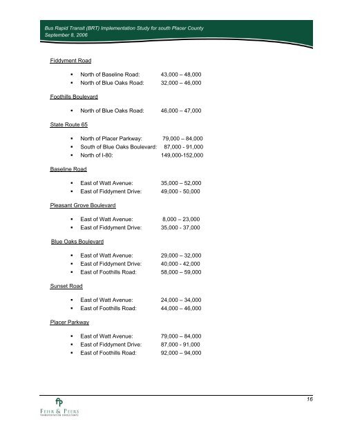
<strong>Bus</strong> <strong>Rapid</strong> <strong>Transit</strong> (<strong>BRT</strong>) <strong>Implementation</strong> <strong>Study</strong> <strong>for</strong> south Placer CountySeptember 8, 2006Fiddyment Road• North of Baseline Road: 43,000 – 48,000• North of Blue Oaks Road: 32,000 – 46,000Foothills Boulevard• North of Blue Oaks Road: 46,000 – 47,000State Route 65• North of Placer Parkway: 79,000 – 84,000• <strong>South</strong> of Blue Oaks Boulevard: 87,000 - 91,000• North of I-80: 149,000-152,000Baseline Road• East of Watt Avenue: 35,000 – 52,000• East of Fiddyment Drive: 49,000 - 50,000Pleasant Grove Boulevard• East of Watt Avenue: 8,000 – 23,000• East of Fiddyment Drive: 35,000 - 37,000Blue Oaks Boulevard• East of Watt Avenue: 29,000 – 32,000• East of Fiddyment Drive: 40,000 - 42,000• East of Foothills Road: 58,000 – 59,000Sunset Road• East of Watt Avenue: 24,000 – 34,000• East of Foothills Road: 44,000 – 46,000Placer Parkway• East of Watt Avenue: 79,000 – 84,000• East of Fiddyment Drive: 87,000 - 91,000• East of Foothills Road: 92,000 – 94,00016