view issue - Adventure World Magazine
view issue - Adventure World Magazine
view issue - Adventure World Magazine

Create successful ePaper yourself
Turn your PDF publications into a flip-book with our unique Google optimized e-Paper software.
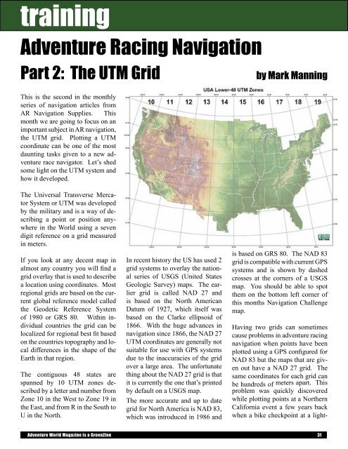
training<strong>Adventure</strong> Racing NavigationPart 2: The UTM GridThis is the second in the monthlyseries of navigation articles fromAR Navigation Supplies. Thismonth we are going to focus on animportant subject in AR navigation,the UTM grid. Plotting a UTMcoordinate can be one of the mostdaunting tasks given to a new adventurerace navigator. Let’s shedsome light on the UTM system andhow it developed.by Mark ManningThe Universal Transverse MercatorSystem or UTM was developedby the military and is a way of describinga point or position anywherein the <strong>World</strong> using a sevendigit reference on a grid measuredin meters.If you look at any decent map inalmost any country you will find agrid overlay that is used to describea location using coordinates. Mostregional grids are based on the currentglobal reference model calledthe Geodetic Reference Systemof 1980 or GRS 80. Within individualcountries the grid can belocalized for regional best fit basedon the countries topography and localdifferences in the shape of theEarth in that region.The contiguous 48 states arespanned by 10 UTM zones describedby a letter and number fromZone 10 in the West to Zone 19 inthe East, and from R in the South toU in the North.In recent history the US has used 2grid systems to overlay the nationalseries of USGS (United StatesGeologic Survey) maps. The earliergrid is called NAD 27 andis based on the North AmericanDatum of 1927, which itself wasbased on the Clarke ellipsoid of1866. With the huge advances innavigation since 1866, the NAD 27UTM coordinates are generally notsuitable for use with GPS systemsdue to the inaccuracies of the gridover a large area. The unfortunatething about the NAD 27 grid is thatit is currently the one that’s printedby default on a USGS map.The more accurate and up to dategrid for North America is NAD 83,which was introduced in 1986 andis based on GRS 80. The NAD 83grid is compatible with current GPSsystems and is shown by dashedcrosses at the corners of a USGSmap. You should be able to spotthem on the bottom left corner ofthis months Navigation Challengemap.Having two grids can sometimescause problems in adventure racingnavigation when points have beenplotted using a GPS configured forNAD 83 but the maps that are givenout have a NAD 27 grid. Thesame coordinates for each grid canbe hundreds of meters apart. Thisproblem was quickly discoveredwhile plotting points at a NorthernCalifornia event a few years backwhen a bike checkpoint at a light-<strong>Adventure</strong> <strong>World</strong> <strong>Magazine</strong> is a GreenZine 31