view issue - Adventure World Magazine
view issue - Adventure World Magazine
view issue - Adventure World Magazine

You also want an ePaper? Increase the reach of your titles
YUMPU automatically turns print PDFs into web optimized ePapers that Google loves.
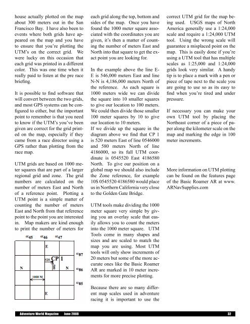
house actually plotted on the mapabout 300 meters out in the SanFrancisco Bay. I have also been toevents where both grids have appearedon the map and you haveto ensure that you’re plotting theUTM’s on the correct grid. Wewere lucky on this occasion thateach grid was printed in a differentcolor. This was one time when itreally paid to listen at the pre racebriefing.It is possible to find software thatwill convert between the two grids,and most GPS systems can be configuredto either, but the importantpoint to remember is that you needto know if the UTM’s you’ve beengiven are correct for the grid printedon the map, especially if theycame from a race director using aGPS rather than plotting from therace map.UTM grids are based on 1000 metersquares that are part of a largerregional grid and zone. The gridnumbers are calculated on thenumber of meters East and Northof a reference point. Plotting aUTM point is a simple matter ofcounting the number of metersEast and North from that referencepoint to the point you are interestedin. Map makers are kind enoughto print the number of meters foreach grid along the top, bottom andsides of the map. Once you havefound the 1000 meter square associatedwith the coordinates you aregiven, it’s then a matter of countingthe number of meters East andNorth into that square to get the exactpoint you are looking for.In the example above the line E-E is 546,000 meters East and lineN-N is 4,186,000 meters North ofthe reference. As each square is1000 meters wide we can dividethe square into 10 smaller squaresto give our location to 100 meters.We could then divide those smaller100 meter squares by 10 to giveour location to 10 meters.If we divide up the square in thediagram above we find that CP 1is 520 meters East of line 0546000and 580 meters North of line4186000, so its full UTM coordinateis 0545520 East 4186580North. To give our position on aglobal map we should also includethe Zone reference, for example10S 0545520 4186580 would placeus in Northern California very closeto the Golden Gate Bridge.UTM tools make dividing the 1000meter square very simple by givingyou an overlay scale that easilyallows you to count the metersinto the 1000 meter square. UTMTools come in many shapes andsizes and are scaled to match themap you are using. Most UTMtools will only show increments of20 meters but some of the more accurateones like the Basic RoamerAR are marked in 10 meter incrementsfor more precise plotting.Because there are so many differentmap scales used in adventureracing it is important to use thecorrect UTM grid for the map beingused. USGS maps of NorthAmerica generally use a 1:24,000scale and require a 1:24,000 UTMtool. Using the wrong scale willguarantee a misplaced point on themap. This is easily done if you’reusing a UTM tool that has multiplescales as 1:25,000 and 1:24,000grids look very similar. A handytip is to place a mark with a pen orpiece of tape next to the scale youare going to use so as its easy tofind when you’re tired and underpressure.If necessary you can make yourown UTM tool by placing theNortheast corner of a piece of paperalong the kilometer scale on themap and marking the edge in 100meter increments.More information on UTM plottingcan be found on the features pageof the Basic Roamer AR at www.ARNavSupplies.com<strong>Adventure</strong> <strong>World</strong> <strong>Magazine</strong> June 2008 32