Development Plan Checklist - OrangeCountyFl.net
Development Plan Checklist - OrangeCountyFl.net
Development Plan Checklist - OrangeCountyFl.net

Create successful ePaper yourself
Turn your PDF publications into a flip-book with our unique Google optimized e-Paper software.
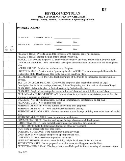
1 ST RE1st RE PROJECT NAME:DEVELOPMENT PLANDRC SUFFICIENCY REVIEW CHECKLISTOrange County, Florida, <strong>Development</strong> Engineering DivisionDPVIEW:APPR1 1st REVIEW: APPROVE REJECT ________________ _______InitialsDate2ND R2 2nd REVIEW: APPROVE REJECT ________________ _______1 st 2 ndRev RevInitialsDatePROJECT TITLE: Provide a plan title consistent with previous approvals and date.PROJECT TITLE: Revise the plan title to that shown above.PARCEL ID#: Provide the parcel ID number on cover sheet under the project title in 30-point font.OWNER/DEVELOPER: Note the owners, developers and consultants involved with the developmentplan..NORTH ARROW: Provide the north arrow on the plan.LOCATION MAP – Provide a stick figure map labeled as SITE. The location map shall identify therelationship of the <strong>Development</strong> <strong>Plan</strong> to the approved Land Use <strong>Plan</strong>.LEGAL DESCRIPTION: Provide a legal description of the tract to be subdivided and approximateacreage.SKETCH OF LEGAL DESCRIPTION: Provide a separate plan sheet with a sketch of LegalDescription that includes bearings, distances, Point of Beginning, etc., for staff verification of Legal.PLAN SIZE: Submit the plan on 24-inch vertical by 36-inch wide sheets.PLAN SET: Staple all sheets together to create 1 set of plans and submit folded sets of plans.PRELIMINARY SUBDIVISION PLAN: Submit plans for a preliminary subdivision plan, as this planproposes a subdivision of property.WAIVERS: Note all waiver requests, including comprehensive justification, on the plan.PROPOSED USES: Note all proposed uses.RESIDENTIAL UNITS: Note the number of dwelling units proposed.RESIDENTIAL DENSITY: Note the proposed residential density.RESIDENTIAL FLOOR AREA: Note the minimum square footage of living area under heat and cooledarea.RESIDENTIAL LOT AREA: Note the minimum <strong>net</strong> lot area.COMMERCIAL SQ FT: Note the total square footage of commercial development.INDUSTRIAL SQ FT: Note the total square footage of industrial development.OFFICE SQ FT: Note the total square footage of office development.FAR: Note all appropriate floor area ratios.BUILDING COVERAGE: Note maximum building coverage.OPEN SPACE: Note acreage and percent open space and class.IMPERVIOUS: Note maximum impervious coverage.BUILDING HEIGHT: Note maximum building height for all uses in feet and stories.RECREATION AREA: Locate proposed recreation areas, detailing proposed facilities.PEDESTRIAN/BIKE WAY: Display pedestrian and bike path facilities, showing all interconnectionsRev 9/05
DEVELOPMENT PLANDRC SUFFICIENCY REVIEW CHECKLISTOrange County, Florida, <strong>Development</strong> Engineering DivisionDPwith existing facilities.STORMWATER MANAGEMENT: Provide stormwater management plan, including direction ofsurface drainage flow.BUILDING SETBACKS: Note all building setbacks from streets and highways.BUILDING SETBACK NHWE: Illustrate 50’ building setback line from the NHWE of all surfacewater bodies.ECON RIVER BASIN: This project is within the Econ River Basin as defined by Ordinance #90-30.Certain items of information are required at this time. Contact John Geiger, EPD, 407-836-1504.PHASING: Note the proposed phasing of the project on the planTOPOGRAHY: Provide certified topography drawn at one (1’) foot contours using Orange Countydatum. .SOILS: Identify on-site soils using the Soil Conservation Service Classification System.VEGETATION: Note existing on-site vegetation.STREETS WITHIN 500’: Provide the name, location, pavement and right of way width for all existingstreets, rights of way and platted streets within 500’ in each direction of all proposed access points.STREET IMPROVEMENTS: Show proposed surface improvements to primary streets serving theproject.WATER SERVICE: Note water service provider and display proposed tie-in to the service.WASTEWATER SERVICE: Note service provider and display proposed tie-in to the service.REFUSE STORAGE: Locate all proposed refuse storage areas.EASEMENTS: Display all existing and proposed easements.PARKING: Provide parking calculations and depict all proposed parking, consistent with Article XIXof the Zoning resolution.COMMERCIAL DESIGN STANDARDS: Note compliance with the Commercial Design Standards setforth in Article XIII of Chapter 9 of the OC CodeEXTERIOR LIGHTING: Include a Lighting <strong>Plan</strong> per the Lighting OrdinanceLIGHTING: Note that Lighting shall comply with Art XVI of Chapter 9 of the OC Code on the plans inaddition to including the Lighting <strong>Plan</strong>.LANDSCAPE: Include a landscape plan.TREE SURVEY: A tree survey is required in accordance with Ch. 15-301 if this DP is not part of apreviously approved PSP. Contact the Zoning Arbor Office at 407-836-5807 for specific tree surveyrequirements.FIRE HYDRANTS: Hydrant locations must be shown, including one by the entrance, so fire apparatuspass it before reaching the first structure.STRUCTURE RENDERING: Include design elevations or renderings of proposed structures.SIGN PLAN: Note signage to comply with Chap 31.5 on the planCAD: An approved Conservation Area Determination by EPD is required prior to DRC review. Submita CAD approval letter or contact John Geiger, EPD, at 407-836-1504.PRELIMINARY ENGR PLANS: Provide preliminary engineering plans for roads, water, wastewaterand stormwater (including relationship to master stormwater concept).OTHER:Rev 9/05
DEVELOPMENT PLANDRC SUFFICIENCY REVIEW CHECKLISTOrange County, Florida, <strong>Development</strong> Engineering DivisionDPRev 9/05