

Caring for Country â The Otways and You - Parks Victoria
Caring for Country â The Otways and You - Parks Victoria
Caring for Country â The Otways and You - Parks Victoria
- No tags were found...

You also want an ePaper? Increase the reach of your titles
YUMPU automatically turns print PDFs into web optimized ePapers that Google loves.
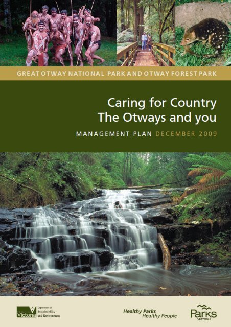
CARING FOR COUNTRY — THE OTWAYS AND YOUGreat Otway National Park <strong>and</strong> Otway Forest ParkManagement PlanDecember 2009
Published in December 2009 by<strong>Parks</strong> <strong>Victoria</strong>, Level 10, 535 Bourke Street, Melbourne, <strong>Victoria</strong> 3000<strong>and</strong> the Department of Sustainability <strong>and</strong> Environment, 8 Nicholson Street, East Melbourne 3002<strong>Parks</strong> <strong>Victoria</strong> <strong>and</strong> DSE 2009, <strong>Caring</strong> <strong>for</strong> <strong>Country</strong> — <strong>The</strong> <strong>Otways</strong> <strong>and</strong> <strong>You</strong>. Great Otway National Park <strong>and</strong> Otway ForestPark Management Plan, <strong>Parks</strong> <strong>Victoria</strong> <strong>and</strong> DSE, MelbourneCover photos from top left: Gunditjmara <strong>and</strong> Kirrae Whurrong dance group (Photo: Terry Woodcroft), <strong>and</strong> Melba Gully,Spot-tailed Quoll <strong>and</strong> Cora Lynn Cascades (Photos: <strong>Parks</strong> <strong>Victoria</strong>)National Library of Australia Cataloguing-in-Publication entry<strong>Caring</strong> <strong>for</strong> <strong>Country</strong> — <strong>The</strong> <strong>Otways</strong> <strong>and</strong> <strong>You</strong>.Great Otway National Park <strong>and</strong> Otway Forest ParkManagement Plan / <strong>Parks</strong> <strong>Victoria</strong> <strong>and</strong>Dept of Sustainability <strong>and</strong> EnvironmentISBN 9780731183845 (pbk)Bibliography.National parks <strong>and</strong> reserves--<strong>Victoria</strong>--Otway Range.Tourism--<strong>Victoria</strong>--Otway Range--Planning.Recreation--<strong>Victoria</strong>--Otway Range--Planning.Otway National Park (Vic.)Otway Forest Park (Vic.)<strong>Parks</strong> <strong>Victoria</strong>.<strong>Victoria</strong>. Dept of Sustainability <strong>and</strong> Environment333.783099457AcknowledgementsAcknowledgement of <strong>Country</strong>: In their rich culture, Aboriginal Australians are intrinsically connectedto the continent — including the area now known as <strong>Victoria</strong>. <strong>Parks</strong> <strong>Victoria</strong> <strong>and</strong> the Department ofSustainability <strong>and</strong> Environment recognise that the parks are part of <strong>Country</strong> of the Traditional Owners.<strong>Parks</strong> <strong>Victoria</strong> <strong>and</strong> the Department of Sustainability <strong>and</strong> Environment are grateful to all thoseorganisations <strong>and</strong> individuals who have contributed to this Management Plan.Note:Technical terms used in this plan are explained in the Glossary at the end of the plan.DisclaimersThis plan is prepared without prejudice to any negotiated or litigated outcome of any native title determination applicationscovering l<strong>and</strong> or waters in the plan’s area. It is acknowledged that any future outcomes of native title determinationapplications may necessitate amendment of this plan; <strong>and</strong> the implementation of this plan may require further notificationsunder the procedures in Division 3 of Part 2 of the Native Title Act 1993 (Cwlth).<strong>The</strong> plan is also prepared without prejudice to any future negotiated outcomes between the Government/s <strong>and</strong> <strong>Victoria</strong>nAboriginal communities. It is acknowledged that such negotiated outcomes may necessitate amendment of this plan.Every ef<strong>for</strong>t has been made to ensure that the in<strong>for</strong>mation in this plan is accurate. <strong>Parks</strong> <strong>Victoria</strong> <strong>and</strong> the Department ofSustainability <strong>and</strong> Environment do not guarantee that the publication is without flaw of any kind <strong>and</strong> there<strong>for</strong>e disclaims allliability <strong>for</strong> any error, loss or other consequence that may arise from you relying on any in<strong>for</strong>mation in the publication.Text printed on 100% recycled paper to help save our natural environmentiiGreat Otway National Park <strong>and</strong> Otway Forest Park Management Plan
FOREWORDGreat Otway National Park protects extensive<strong>for</strong>est <strong>and</strong> much of the coastline betweenTorquay <strong>and</strong> Princetown in south-west<strong>Victoria</strong>. Otway Forest Park includes mountain<strong>and</strong> foothill <strong>for</strong>ests on the northern fall of theOtway range, adjacent to the national park.<strong>The</strong> <strong>Otways</strong> have always been, <strong>and</strong> willcontinue to be, a place <strong>for</strong> people. <strong>The</strong> creationof the parks represented substantial progress inachieving a major change in direction <strong>for</strong> themanagement of public l<strong>and</strong> in the <strong>Otways</strong>. <strong>The</strong>parks make a substantial contribution to theconservation of biodiversity <strong>and</strong> culturalvalues. <strong>The</strong>y will also continue to be animportant aspect of local lifestyles <strong>and</strong> supporta broad range of nature based recreationexperiences <strong>and</strong> a vibrant regional tourismindustry.<strong>Parks</strong> play a vital role in ensuring the health<strong>and</strong> wellbeing of society by providing clean air<strong>and</strong> water, protecting biodiversity <strong>and</strong> habitat<strong>for</strong> native species, sequestering carbon <strong>and</strong>other ecosystem services. <strong>Parks</strong> also provideopportunities to connect with each other in anatural setting thereby reducing stress. Healthy<strong>Parks</strong> Healthy People is all about conservingthe natural <strong>and</strong> cultural values to sustaincommunities.<strong>The</strong> parks are an integral part of KirraeWhurrong, Gulidjan, Gadubanud <strong>and</strong>Wathaurong <strong>Country</strong>, <strong>and</strong> <strong>Parks</strong> <strong>Victoria</strong> <strong>and</strong>the Department of Sustainability <strong>and</strong>Environment are working with TraditionalOwners <strong>and</strong> other Indigenous people tosupport greater involvement in management ofparks.This approved plan establishes a shared vision<strong>for</strong> management <strong>and</strong> clear strategic goals <strong>for</strong>the long-term management of the parks. Aheadlies a challenge to involve the wider Otway<strong>and</strong> <strong>Victoria</strong>n communities, visitors <strong>and</strong>government agencies in implementing the planto achieve the shared vision of protecting theparks <strong>for</strong> the enjoyment of current <strong>and</strong> futuregenerations.Great Otway National Park <strong>and</strong> Otway Forest Park Management Planiii
APPROVED MANAGEMENT PLANThis management plan, prepared under section 17of the National <strong>Parks</strong> Act 1975 (Vic.) <strong>and</strong> section22 of the Forests Act 1958 (Vic.), is approved <strong>for</strong>implementation.<strong>The</strong> plan provides the basis <strong>for</strong> the futuremanagement of Great Otway National Park <strong>and</strong>Otway Forest Park. It was finalised followingconsideration of the 493 submissions <strong>and</strong> 367additional comments received on the DraftManagement Plan.ivGreat Otway National Park <strong>and</strong> Otway Forest Park Management Plan
ContentsTABLESFIGURES1 Management zones <strong>and</strong> overlays 142 Summary of permitted activities 153 Management of visitor sites <strong>and</strong> services 464 Management of walking <strong>and</strong> shared tracks <strong>and</strong> routes 535 Designated companion dog area in Great Otway National Park 606 Roads open <strong>for</strong> horse riding in Great Otway National Park 631 Management zoning End of plan2 Visitor access <strong>and</strong> facilities "viiiGreat Otway National Park <strong>and</strong> Otway Forest Park Management Plan
1 INTRODUCTION1.1 Location <strong>and</strong> planning area<strong>The</strong> planning area comprises Great OtwayNational Park <strong>and</strong> Otway Forest Park.Together the parks total just over 140 000 ha<strong>and</strong> are located south-west of Melbournebetween Torquay <strong>and</strong> Princetown, extendingfrom the coast almost to the Princes Highway.Great Otway National Park (103 185 ha)includes extensive <strong>for</strong>ests <strong>and</strong> heathl<strong>and</strong>s onmuch of the southern fall <strong>and</strong> many northernareas of the Otway Ranges, <strong>and</strong> much of thecoastline between Torquay in the east <strong>and</strong>Princetown in the west. Its coastal boundary isgenerally the low water mark (figure 1).Otway Forest Park (39 520) generally includesmountain <strong>and</strong> foothill <strong>for</strong>ests on the northernfall of the Otway Ranges, much of which isadjacent to Great Otway National Park (figure1).<strong>The</strong>se parks encompass a significant portion ofthe Otway Ranges <strong>and</strong> foothills. Both parkscomprise large blocks of public l<strong>and</strong>, but notall the blocks are contiguous. <strong>The</strong>re are manyprivate l<strong>and</strong> holdings <strong>and</strong> small ruralcommunities interspersed with, <strong>and</strong> adjacent tothe parks, <strong>and</strong> several larger towns nearby,including Colac, Anglesea <strong>and</strong> Apollo Bay.Within the planning area, Great OtwayNational Park includes:• eight reference areas: Aquila Creek, CalderRiver, Crinoline Creek, Olangolah Creek,Painkalac Creek, Parker River, PorcupineCreek <strong>and</strong> Stony Creek• the majority of the Aire Heritage Rivercorridor• two Designated Water Supply CatchmentAreas covering five different areas (section8.4)• parts of several Special Water SupplyCatchment Areas that also cover parts ofthe <strong>for</strong>est park (section 8.4).<strong>The</strong> Great Ocean Road, Beech Forest Road,Carlisle–Colac Road, Colac–Lavers Hill Road,Deans Marsh– Lorne Road, Forrest–ApolloBay Road, Gellibr<strong>and</strong> River Road, LaversHill–Cobden Road, Otway Lighthouse Road,Princetown Road <strong>and</strong> Skenes Creek Road areexcluded from the parks.1.2 Creation of the parks<strong>The</strong> <strong>Victoria</strong>n Environmental AssessmentCouncil (VEAC) commenced an investigationrelating to Angahook–Lorne State Park in2002. Since the 1980s, the environmentalcommunity advocated <strong>for</strong> the cessation oflogging in the <strong>Otways</strong> (section 2.3). <strong>The</strong>purpose of the investigation was laterexp<strong>and</strong>ed to include the investigation of asingle national park in the Otway Ranges <strong>and</strong>the addition of State <strong>for</strong>est areas to theprotected area network.<strong>The</strong> Council’s final report (VEAC 2004) wasreleased in November 2004 after extensiveresearch, analysis <strong>and</strong> community consultation.<strong>The</strong> majority of the final recommendationswere accepted by the <strong>Victoria</strong>n Government(Government of <strong>Victoria</strong> 2005); including thecreation of a large new national park, a <strong>for</strong>estpark <strong>and</strong> three new reference areas (PorcupineCreek, Aquila Creek <strong>and</strong> Painkalac Creek).Great Otway National Park was included onSchedule Two to the National <strong>Parks</strong> Act 1975(Vic.) on 11 December 2005. It includes the<strong>for</strong>mer Otway National Park <strong>and</strong> Melba GullyState Park, most of Angahook–Lorne StatePark <strong>and</strong> Carlisle State Park, a number of<strong>for</strong>mer State <strong>for</strong>est areas, many smallerreserves <strong>and</strong> other areas of public l<strong>and</strong>. L<strong>and</strong> atIronbark Basin, Sabine Falls <strong>and</strong> multiple areas<strong>for</strong>merly owned <strong>and</strong> managed by watercorporations were added to the national park in2006.Following amendments to the Crown L<strong>and</strong>(Reserves) Act 1978 (Vic.) <strong>and</strong> the Forests Act1958 (Vic.), Otway Forest Park wasproclaimed on 24 October 2006. Otway ForestPark includes <strong>for</strong>mer Otway State Forest areas,Karwarren Regional Park <strong>and</strong> other smallerreserves.1.3 National park <strong>and</strong> Forest parkGreat Otway National Park <strong>and</strong> Otway ForestPark complement each other <strong>and</strong> togetherprovide <strong>for</strong> natural <strong>and</strong> cultural valuesconservation, the provision of tourism <strong>and</strong>recreation experiences, <strong>and</strong> access to <strong>for</strong>estGreat Otway National Park <strong>and</strong> Otway Forest Park Management Plan 1
Introductionproducts across the <strong>Otways</strong>. <strong>The</strong> parks aremanaged under separate legislation <strong>and</strong>, insome cases, policies, guidelines <strong>and</strong>prescriptions (sections 2.5 <strong>and</strong> 2.6).<strong>The</strong> Great Otway National Park is managedunder the National <strong>Parks</strong> Act, to preserve <strong>and</strong>protect its natural condition <strong>for</strong> use, enjoyment<strong>and</strong> education of the public, <strong>and</strong> <strong>for</strong> protectionof indigenous flora <strong>and</strong> fauna, <strong>and</strong> features ofscenic, archaeological, ecological, geologicalhistoric or other scientific interest. Protectingwater quality <strong>and</strong> yield is the paramountconsideration in managing Designated WaterSupply Catchment Areas (appendix 1).<strong>The</strong> Otway Forest Park is managed under theForests Act. <strong>The</strong> park is managed to: (i)provide opportunities <strong>for</strong> in<strong>for</strong>mal recreationassociated with the enjoyment of naturalsurroundings (ii) protect <strong>and</strong> conservebiodiversity, natural <strong>and</strong> cultural features <strong>and</strong>water supply catchments; <strong>and</strong> (iii) supply alimited range of natural resource products(appendix 1).1.4 Plan developmentThis Management Plan <strong>for</strong> the parks wasprepared by <strong>Parks</strong> <strong>Victoria</strong> <strong>and</strong> the Departmentof Sustainability <strong>and</strong> Environment (DSE), withsignificant input from agencies <strong>and</strong> the widercommunity. It takes into account legislation,l<strong>and</strong> use proclamations, policies, reports,research findings <strong>and</strong> community knowledge<strong>and</strong> aspirations that relate to the parks.In particular, the plan builds on thegovernment response to the VEACrecommendations (Government of <strong>Victoria</strong>2005), <strong>and</strong> the creation of the parks in 2005<strong>and</strong> 2006.<strong>The</strong> plan content has further been in<strong>for</strong>med byan extensive community engagement programunder the guidance of the <strong>Otways</strong> L<strong>and</strong>scapeCommunity Council (OLCC), appointed by theMinister <strong>for</strong> Environment in 2006. <strong>The</strong> OLCCcomprised seven members <strong>and</strong> a chairpersonwith good community networks <strong>and</strong> a stronginterest in the <strong>Otways</strong>. Public comment wasinvited on three draft plans from 14 March to 2June 2008, the Draft Management Plan, theDraft Recreation <strong>and</strong> Tourism Access Plan(<strong>Parks</strong> <strong>Victoria</strong> & DSE 2008b) <strong>and</strong> the DraftHeritage Action Plan (<strong>Parks</strong> <strong>Victoria</strong> & DSE2008a).Various opportunities were given <strong>for</strong> commentincluding by post, email, fax, in person at‘open house’ public <strong>for</strong>ums <strong>and</strong> via an ‘e<strong>for</strong>um’internet discussion board. A total of493 <strong>for</strong>mal written submissions <strong>and</strong> 367comments were received from organisations,groups <strong>and</strong> individuals (appendix 5). <strong>The</strong>sewere carefully considered in the preparation ofthis approved plan.<strong>The</strong> plan is a strategic guide <strong>for</strong> managers ofthe park. It in<strong>for</strong>ms the development of yearlycorporate plans, serves as a framework <strong>for</strong>subsequent detailed planning <strong>and</strong> governsmanagement activities. However, as a publicdocument, this plan is intended to bein<strong>for</strong>mative <strong>for</strong> a wider, non-specialistaudience.Key changes made to the draft managementplan in preparing this approved managementplan included:• incorporation of the key elements DraftRecreation <strong>and</strong> Tourism Access Plan <strong>and</strong>Draft Heritage Action Plan (<strong>Parks</strong> <strong>Victoria</strong>& DSE 2008a & 2008b) into a singlel<strong>and</strong>scape–scale strategic plan to guidemanagement of the parks• retaining these two draft documents asimportant resource material <strong>for</strong> futuremanagement of the parks• an enhanced focus on Traditional Ownerpartnerships <strong>and</strong> improving Aboriginalrepresentation <strong>and</strong> involvement in decisionmaking <strong>and</strong> management of the parks• emphasis on integration of partnershipswith community groups <strong>and</strong> agencies withcommon goals relating to the area• improving protection <strong>for</strong> environmentalvalues by assigning a conservation zone inthe national park, based on currentbiodiversity condition modelling, <strong>and</strong>special protection zone in the <strong>for</strong>est park,based on the special protection zone in theWest <strong>Victoria</strong> Regional Forest Agreement• improving protection <strong>for</strong> ecosystemservices <strong>and</strong> water quality through theimplementation of closed catchments <strong>for</strong>Designated Water Supply Catchments• providing greater emphasis on integratedfire management <strong>and</strong> protection ofcommunities2 Great Otway National Park <strong>and</strong> Otway Forest Park Management Plan
Introduction• clear criteria <strong>for</strong> assessment of all newdevelopment proposals in the parks todetermine suitability, priority <strong>and</strong> timing• further refinement of access to ensure asustainable approach <strong>for</strong> the variety of uses<strong>and</strong> more detailed in<strong>for</strong>mation aboutvisitor sites <strong>and</strong> facilities, walking <strong>and</strong>shared tracks <strong>and</strong> routes, <strong>and</strong> areasavailable <strong>for</strong> dog walking <strong>and</strong> horse riding• generally adopting the less restrictiveoption <strong>for</strong> dog access areas in the nationalpark <strong>and</strong> no timing restrictions on beachaccess <strong>for</strong> horses• restructuring the plan with separatesections added to give clearer direction <strong>for</strong>• Traditional Owner partnerships <strong>and</strong>Aboriginal involvement in the parks’management• recreational fishing• events <strong>and</strong> commercial activities• development assessment criteria• <strong>and</strong> removal of the section oncommercial timber harvesting ascommercial timber harvesting in theForest Park has been completed.• inclusion of tourism initiatives such as thedevelopment of a nature-basedaccommodation ‘eco-lodge’, demountableaccommodation, Indigenous tourism <strong>and</strong>historic heritage tourism as tourismdirections. <strong>The</strong>se are exciting potentialopportunities requiring further assessment<strong>and</strong> planning, <strong>and</strong> exploration ofpartnerships with the private <strong>and</strong> publicsectors.This plan replaces the following managementplans:• Angahook–Lorne State Park ManagementPlan (<strong>Parks</strong> <strong>Victoria</strong> 1999)• Otway National Park Management Plan(NRE 1996a)• Melba Gully State Park Management Plan(NRE 1996b)• Carlisle State Park Management Plan(<strong>Parks</strong> <strong>Victoria</strong> 1998)• Forest Management Plan <strong>for</strong> the OtwayForest Management Area (DCE 1992).Great Otway National Park <strong>and</strong> Otway Forest Park Management Plan 3
2 BASIS2.1 Regional context<strong>The</strong> coasts, rivers, mountains, heath l<strong>and</strong>s <strong>and</strong><strong>for</strong>ests of Great Otway National Park <strong>and</strong>Otway Forest Park are some of the manydiverse highlights in this region known as theOtway Ranges. Agricultural l<strong>and</strong>, timberplantations, the Great Ocean Road, coastaltowns <strong>and</strong> rural towns are also prominent inthe l<strong>and</strong>scape. This l<strong>and</strong>scape, the parks, <strong>and</strong>places in the parks have special value to manypeople, including Aboriginal communities,local residents <strong>and</strong> visitors.Aboriginal tradition indicates that the parks arepart of <strong>Country</strong> of the Gadubanud,Wathaurong, Gulidjan <strong>and</strong> Kirrae Whurrongpeople. Relevant local Aboriginalorganisations include the Traditional Owners(Kirrae Whurrong, Gulidjan <strong>and</strong> Wathurong).<strong>The</strong> Framlingham Aboriginal Trust <strong>and</strong>Wathaurong Aboriginal Co-operative are alsoimportant local Aboriginal groups with astrong interest in the parks. Many Aboriginalpeople residing in the region may not beassociated with any of these groups. OtherAboriginal people may reside outside theregion but have an historic or traditional linkwith it.Together, Great Otway National Park <strong>and</strong>Otway Forest Park provide a complementarysuite of opportunities <strong>for</strong> enhanced natureconservation, protection of cultural <strong>and</strong>lifestyle values <strong>and</strong> outst<strong>and</strong>ing recreation <strong>and</strong>tourism experiences on public l<strong>and</strong>.Great Otway National Park is a park ofnational significance, <strong>and</strong> was establishedbased on national criteria <strong>for</strong> conservation. <strong>The</strong>coordinated management of Great OtwayNational Park <strong>and</strong> Otway Forest Park furtherenhances the network of parks <strong>and</strong> provides <strong>for</strong>a regional, l<strong>and</strong>scape-scale approach tomanaging biodiversity, natural resources <strong>and</strong>the provision of ecosystem services.<strong>The</strong> two parks contain an enormous diversityof life, with ecosystems ranging from oceanbeaches to cool temperate rain<strong>for</strong>est. Sevennational <strong>and</strong> <strong>Victoria</strong>n bioregions arerepresented in the parks. Most ecosystems arein good condition <strong>and</strong> are protected in areaslarge enough to sustain largely naturalecological processes.Several important water catchments are withinthe parks: the majority of the Otway CoastBasin <strong>and</strong> part of the Barwon Basin. <strong>The</strong>secatchments, part of the CorangamiteCatchment Management Authority Region(section 4.4) contain important water supplycatchments <strong>for</strong> townships betweenWarrnambool <strong>and</strong> Geelong (section 8.4).<strong>The</strong> parks are a keystone <strong>for</strong> managing crosstenurel<strong>and</strong> management issues in the <strong>Otways</strong>such as road management, recreation, pestplants <strong>and</strong> animals, <strong>and</strong> wildfire. Cross-tenureco-operation <strong>and</strong> integrated planning withother authorities <strong>and</strong> private l<strong>and</strong> owners iscrucial to delivering outcomes.<strong>The</strong> parks are within the Surf Coast,Corangamite <strong>and</strong> Colac Otway Shires. <strong>The</strong>creation of these parks <strong>and</strong> the cessation ofsawlog <strong>and</strong> pulpwood harvesting on publicl<strong>and</strong> in the <strong>Otways</strong> in 2008 had significanteconomic <strong>and</strong> social implications <strong>for</strong> theseshires <strong>and</strong> the <strong>Otways</strong> region. <strong>The</strong>re are nowincreased opportunities in plantation <strong>for</strong>estry<strong>and</strong> a strengthened future <strong>for</strong> key industriesassociated with tourism <strong>and</strong> recreation.Great Otway National Park is an integralelement of <strong>Victoria</strong>’s most popular regionaltourism destination. <strong>The</strong> Great Ocean Road, anAustralian National L<strong>and</strong>scape (section 2.2)<strong>and</strong> internationally recognised touring route,winds through Great Otway National Park <strong>and</strong>provides access to many of the park’sattractions.Other nearby parks include:• Port Campbell National Park• Twelve Apostles <strong>and</strong> Point Addis MarineNational <strong>Parks</strong>• <strong>The</strong> Arches, Marengo Reefs <strong>and</strong> EagleRock Marine Sanctuaries• Anglesea Heath (Alcoa lease area).2.2 Park significance <strong>and</strong> valuesGreat Otway National Park <strong>and</strong> Otway ForestPark make a valuable contribution to<strong>Victoria</strong>’s parks <strong>and</strong> reserves system, which4 Great Otway National Park <strong>and</strong> Otway Forest Park Management Plan
Basisaims to protect viable, comprehensive,adequate <strong>and</strong> representative examples of theState’s natural environments, along withproviding opportunities <strong>for</strong> visitors to enjoy<strong>and</strong> appreciate the natural environment <strong>and</strong>natural <strong>and</strong> cultural features.<strong>The</strong> <strong>for</strong>est park offers Otway communities theopportunity to continue to enjoy the lifestylebenefits associated with living near large areasof bushl<strong>and</strong>, including sustainable firewood<strong>and</strong> minor <strong>for</strong>est produce collection, <strong>and</strong> variedrecreation opportunities.Great Otway National Park is assigned theIUCN – World Conservation Union CategoryII of the United Nations List of National <strong>Parks</strong><strong>and</strong> Protected Areas. Category II areas aremanaged mainly <strong>for</strong> ecosystem conservation<strong>and</strong> recreation. On a statewide basis thenational park is rated as very high <strong>for</strong> theprotection of natural values.Otway Forest Park is a new l<strong>and</strong> use category<strong>for</strong> <strong>Victoria</strong> <strong>and</strong> is not assigned an IUCNcategory.<strong>The</strong> Great Ocean Road National L<strong>and</strong>scapehas been included in the National L<strong>and</strong>scapesList which contains the best of Australia’snatural <strong>and</strong> cultural l<strong>and</strong>scapes.Many areas have been included on the Registerof the National Estate <strong>and</strong> are now part of theparks, including:• the <strong>for</strong>mer Angahook–Lorne State Park<strong>and</strong> adjacent areas• Anglesea Heath – Bald Hills Area• Cape Otway Lightstation• the <strong>for</strong>mer Melba Gully State Park• the <strong>for</strong>mer Otway National Park <strong>and</strong>adjacent areas• Otway Stonefly Habitat – Maits Rest• Urquhart Bluff area• the headwaters of Lake Elizabeth.Significant existing features <strong>and</strong> opportunitiesof the parks include the following:Natural• Large areas of intact native vegetation <strong>and</strong>habitats of the Otway Ranges, OtwayPlain, Warrnambool Plain bioregions(section 4.5)• Areas of <strong>for</strong>est in excellent condition,including old growth <strong>for</strong>est, cool temperaterain<strong>for</strong>ests <strong>and</strong> wet <strong>for</strong>ests (section 4.5 <strong>and</strong>appendix 2)• Large portions of the Barwon <strong>and</strong> OtwayCoast river basins, linking largelyunmodified headwaters to streams <strong>and</strong>rivers including the Aire, Gellibr<strong>and</strong> <strong>and</strong>Barwon rivers, then on to estuaries <strong>and</strong> thesea (section 4.4)• A large area of essentially unmodifiedcoastline, linking the l<strong>and</strong> to marineecosystems <strong>and</strong> marine national parks(section 4.4)• An abundance of biodiversity, with manyspecies <strong>and</strong> communities found nowhereelse in <strong>Victoria</strong>, some of which are rare<strong>and</strong> threatened, <strong>and</strong> including some speciesof national significance such as the SpottailedQuoll, Smoky Mouse <strong>and</strong> TallAstelia (sections 4.5, 4.6 <strong>and</strong> appendices 3<strong>and</strong> 4)• Many sites of geological <strong>and</strong>geomorphological significance includingArtillery Rocks, Dinosaur Cove, LionHeadl<strong>and</strong>, Moonlight Head to MilanesiaBeach, Point Sturt <strong>and</strong> View Point (section4.3)• <strong>The</strong> majority of the Aire Heritage Rivercorridor (section 4.4).Cultural• A rich cultural l<strong>and</strong>scape linked throughstories, family, tradition, lore, song,spirituality <strong>and</strong> contemporary meaning tothe Traditional Owners of <strong>Country</strong> (section5.1)• Many significant Aboriginal places <strong>and</strong>objects (section 5.1)• Cape Otway Lightstation, historic places<strong>and</strong> relics associated with ship travel <strong>and</strong>shipwrecks (section 5.2)• Significant historic places includingsawmills, tramways <strong>and</strong> sites with a longtourism history (section 5.2)• Many sites of social significance to whichpeople feel a strong connection (section5.3).Great Otway National Park <strong>and</strong> Otway Forest Park Management Plan 5
BasisRecreation <strong>and</strong> tourism• A diverse range of lifestyle <strong>and</strong> recreationopportunities <strong>for</strong> communities adjacent tothe parks – <strong>for</strong> local permanent residents<strong>and</strong> holiday home owners• Regionally, nationally <strong>and</strong> internationallysignificant tourist attractions, close toaccess routes <strong>and</strong> accommodation, such asspectacular coastal scenery along the GreatOcean Road, access to beautiful beaches,clifftop lookouts, picnic areas, historicsites, waterfalls <strong>and</strong> walking tracks such asthe Great Ocean Walk (section 6.1)• Opportunities <strong>for</strong> exploration by visitors ofall mobility <strong>and</strong> fitness levels, oninfrastructure ranging from boardwalks<strong>and</strong> short loops to longer <strong>and</strong> morestrenuous walking tracks (sections 6.4 <strong>and</strong>6.5)• Various opportunities <strong>for</strong> overnighting inthe parks or in adjoining privateaccommodation – including dispersedcamping, designated secluded orcommunal campsites, high qualitydemountable accommodation/st<strong>and</strong>ingcamps, <strong>and</strong> links to off-parkaccommodation providers in closeproximity (sections 6.1 <strong>and</strong> 6.6)• Specific provision <strong>for</strong> particular recreationactivities such as maintaining access <strong>for</strong>recreational fishing including to remotebeaches <strong>for</strong> fishing or surfing, routes <strong>for</strong>vehicle touring, dedicated mountain biketracks, areas promoted <strong>for</strong> horse riding, anextensive network of walking tracksincluding walk-in-only camp sites, roughroads with a recreational 4WD trackclassification, trail bike unloading areas,launch sites <strong>for</strong> hang gliding, <strong>and</strong>convenient places <strong>for</strong> dog walking• Opportunities <strong>for</strong> controlled educationalexperiences <strong>for</strong> school groups <strong>and</strong> guidedor self-guided tours, with interpretive‘nature trails’ <strong>and</strong> short <strong>and</strong> medium loopwalks at several key feature sites (sections6.2 <strong>and</strong> 6.4).Community use• Surface <strong>and</strong> groundwater catchments <strong>for</strong>piped domestic <strong>and</strong> industrial water supply<strong>for</strong> the communities of the region,including Otway-sourced reticulated water<strong>for</strong> approximately 285 000 people, <strong>and</strong>industries including milk <strong>and</strong> food, timber<strong>and</strong> paper, fishing <strong>and</strong> seafood textiles <strong>and</strong>clothing, automotive parts, fertiliser <strong>and</strong>metal production (section 8.4)• Natural flows of rivers <strong>and</strong> ground water<strong>for</strong> irrigated agriculture (crops, vegetables,fruit growing <strong>and</strong> viticulture), <strong>and</strong>significant dairying, beef, sheep <strong>and</strong> woolindustries (section 4.4)• Lifestyle <strong>and</strong> health benefits associatedwith access to areas of pleasant naturalbushl<strong>and</strong> <strong>and</strong> spectacular scenery <strong>for</strong> avariety of healthy activities such aswalking, cycling, horse riding <strong>and</strong> dogwalking, or just spending time with friends<strong>and</strong> family• A range of natural resources <strong>for</strong>sustainable utilisation, including firewood,minor <strong>for</strong>est product collection, hunting<strong>and</strong> beekeeping in the <strong>for</strong>est park, <strong>and</strong>fishing in both parks• <strong>The</strong> basis <strong>for</strong> continued growth of naturebasedtourism associated with the parks<strong>and</strong> the region, providing economicopportunities <strong>for</strong> accommodationproviders, food <strong>and</strong> services providers, <strong>and</strong>recreation, tourism <strong>and</strong> educationoperators.2.3 Past uses of the parksGadubanud, Wathaurong, Kirrae Whurrong<strong>and</strong> Gulidjan people have a timeless link with<strong>Otways</strong> <strong>Country</strong>. Middens <strong>and</strong> other sitesalong the coast provide an extensivearchaeological record of historic Aboriginalculture <strong>and</strong> indicate that many people livedalong the Otway coastline <strong>for</strong> thous<strong>and</strong>s ofyears. Maintaining knowledge of culture hasbeen challenging <strong>for</strong> Aboriginal communitiesin <strong>Victoria</strong>, but many aspects of Gadubanud,Wathaurong, Kirrae Whurrong <strong>and</strong> Gulidjancultural heritage have been well documented<strong>and</strong> continue to this day. Many non-physicalaspects such as stories <strong>and</strong> spiritualconnections remain important to both historic<strong>and</strong> contemporary Aboriginal life. WithinGreat Otway National Park <strong>and</strong> Otway ForestPark this connection is reflected in an ongoingdesire to care <strong>for</strong> <strong>Country</strong>.6 Great Otway National Park <strong>and</strong> Otway Forest Park Management Plan
Basis<strong>The</strong> <strong>Otways</strong> played a part in the early days ofEuropean settlement of <strong>Victoria</strong>, with sealersoperating along the coast from about 1800,whaling active in the Apollo Bay area from the1820s to 1840s, <strong>and</strong> Governor La Trobeexploring a route to Cape Otway from the westin 1846.Completed in 1848, the Cape OtwayLighthouse was built in response to numerousshipwrecks <strong>and</strong> increased shipping in BassStrait. Stone came from a quarry at ParkerRiver <strong>and</strong> supplies were l<strong>and</strong>ed at BlanketBay. A telegraph station was built in 1859which played an important role incommunicating shipping movements. Now inGreat Otway National Park, the Lightstationprecinct contains many important historic sites<strong>and</strong> contributes to the spectacular vista of CapeOtway.Coastal <strong>and</strong> low lying areas were taken up <strong>for</strong>grazing by the late 1840s, with several largeruns established. <strong>The</strong> densely <strong>for</strong>ested Otwayranges, however, were not very suitable <strong>for</strong>agriculture. From the 1870s the colonialgovernment promoted settlement <strong>and</strong> releasedlarge tracts of <strong>for</strong>ested country, demonstratinga lack of underst<strong>and</strong>ing of the l<strong>and</strong> <strong>and</strong> itsvalues <strong>and</strong> capability <strong>and</strong> leading to manyfailures. Examples of ab<strong>and</strong>oned farms now inthe parks are found in the Carlisle area, in theAire Valley <strong>and</strong> south of Triplet Falls.Many <strong>for</strong>est areas in the Otway parks have ahistory of logging activity. From a modest startnear present-day Lorne in the late 1840s,logging <strong>and</strong> milling of hardwood timberinitially grew in coastal areas <strong>and</strong> utilised boattransport, such as cutting railway sleepers nearApollo Bay where the local population swelledto about 1000 in 1862. Logging <strong>and</strong> millinggrew to be the dominant industry in the<strong>Otways</strong>, with over 200 mills, making it one ofthe State’s most productive <strong>for</strong>est regions. <strong>The</strong>timber was used to build railways, regionalcities <strong>and</strong> towns <strong>and</strong> in goldmining operations,<strong>and</strong> made major economic <strong>and</strong> socialcontributions to many local communities.Important mills included Henry’s (south ofForrest), Henry’s No 1 mill on the BarwonRiver, Knotts No 1 <strong>and</strong> Knotts No 3 mill nearWyelangata. Numerous timber tramwayswinding through the <strong>for</strong>est fed timber to arailway network. <strong>The</strong> Beechy Line railwaybuilt from Colac to Beech Forest in 1902serviced about 100 mills <strong>and</strong> led to theharvesting of large quantities of timber.Birnum Station remains in the parks today <strong>and</strong>the line has become a recreational rail trail. Inmore recent times <strong>for</strong>estry tracks were openedup to access coupes, <strong>and</strong> many remain,providing an extensive network <strong>for</strong>management <strong>and</strong> recreational access.Experimental softwood plantations wereestablished in areas including the Aire Valleywith a large work camp set up alongside theAire River. In 1936, Redwoods (Sequoiasempervirens) were planted at the camp site;now about 100 remain <strong>and</strong> <strong>for</strong>m a cathedrallikesetting next to the river. Timberproduction later declined as a result of reduceddem<strong>and</strong> in the Depression years <strong>and</strong> otherfactors.Beginning in the 1980s, an activeenvironmental movement advocated thecessation of logging in the <strong>Otways</strong> <strong>and</strong> protestswere held at a range of sites in the <strong>for</strong>estincluding Cianncio Creek, Sabine Falls, WildDogs Ridge <strong>and</strong> Rileys Ridge (seewww.oren.org.au). A shift occurred in public<strong>and</strong> political opinion towards <strong>for</strong>estconservation. Great Otway National Park,incorporating some of these sites <strong>and</strong> <strong>Otways</strong>Forest Park were recommended by VEAC <strong>and</strong>established in 2005 <strong>and</strong> 2006 respectively.Logging on public l<strong>and</strong> in the <strong>Otways</strong> ceasedin 2008.Major wildfires occurred within the OtwayRanges in 1851, 1886, 1898, 1919, 1926, 1939,1951 <strong>and</strong> 1983. Following serious loss of life<strong>and</strong> the destruction of many mills in the 1939bushfires, a network of fire observation towerswas constructed including Peters Hill, MtCowley, Crowes, Mt Pordon <strong>and</strong> Mt Sabine.<strong>The</strong> Mt Sabine tower is the only original towerremaining in the parks.<strong>The</strong> Ash Wednesday fire in 1983 started inDean’s Marsh, <strong>and</strong> burnt over 41 000 ha underextreme conditions. Three lives were lost <strong>and</strong>729 houses destroyed in coastal townshipsincluding Lorne, Fairhaven <strong>and</strong> Aireys Inlet.<strong>The</strong> parks have a long history of tourism.Attractive natural settings became popular inthe late nineteenth century, <strong>and</strong> increasingnumbers of people visited beaches, waterfalls<strong>and</strong> <strong>for</strong>ests in accessible parts of the <strong>Otways</strong>. A<strong>for</strong>mal track was constructed to Erskine Fallsnear Lorne in 1890. Other popular locationsGreat Otway National Park <strong>and</strong> Otway Forest Park Management Plan 7
Basisincluded Kalimna Falls, Cora Lyn Cascades,Cumberl<strong>and</strong> Falls <strong>and</strong> Sheoak Falls. Lorne <strong>and</strong>Apollo Bay became popular tourist localities<strong>and</strong> Colac became a stepping-off point to<strong>for</strong>est sites such as Triplet Falls, HopetounFalls, Beauchamp Falls, Maits Rest <strong>and</strong> MelbaGully. Fishing <strong>and</strong> hunting were also popular.<strong>The</strong> Great Ocean Road was constructed withthe labour of returned servicemen from theFirst World War. Completion of the GreatOcean Road in 1932 led to a trans<strong>for</strong>mation inuse of the <strong>Otways</strong>. Reliable vehicle access toparts of the coast <strong>and</strong> hinterl<strong>and</strong> becamepossible, visitor numbers grew steadily <strong>and</strong> aburgeoning tourism industry developed, withthe road becoming recognised as one of theworld’s most scenic touring routes. Manyspecial places along the Great Ocean Roadbecame popular stopping points. In response toincreasing dem<strong>and</strong>, dedicated visitor facilitiessuch as lookouts, car parks <strong>and</strong> walking trackshave been developed.2.4 Park visitation <strong>and</strong> experiences<strong>The</strong> Great Ocean Road region attractsapproximately 4 million day trip visitors <strong>and</strong>2.4 million domestic overnight visitors peryear, spending approximately 62 milliondollars in the region. Visitors from outside theregion account <strong>for</strong> 65% of visitors to the area.Of these, 87% are from <strong>Victoria</strong> <strong>and</strong> 60% arefrom Melbourne. <strong>The</strong> number of day trips tothe area is declining, while overnight trips <strong>and</strong>international visitor numbers are increasing(Tourism <strong>Victoria</strong> 2006).Many towns in the <strong>Otways</strong> are surrounded bythe parks, which makes the parks veryimportant to permanent <strong>and</strong> seasonal residents.<strong>The</strong>se residents account <strong>for</strong> 35% of all visitorsto the parks (<strong>Parks</strong> <strong>Victoria</strong> unpublished data).Visitor research <strong>for</strong> the year 2005/2006 hasestimated that just over one million visitorsvisited the Great Otway National Park. Manyvisited multiple times, representing 2.3 millionsite visits. <strong>The</strong> Great Ocean Road is the main‘supply’ of visitors with Erskine Falls, MaitsRest, Point Addis, Southside (Bells Beachsouth) <strong>and</strong> Urquhart Bluff all receiving over100 000 visits per annum. Triplet Falls is themost popular hinterl<strong>and</strong> site with 82 500 visitsper annum (<strong>Parks</strong> <strong>Victoria</strong> 2007d).Together, the features <strong>and</strong> facilities of theGreat Otway National Park <strong>and</strong> Otway ForestPark provide a complementary suite of publicl<strong>and</strong> opportunities <strong>for</strong> outst<strong>and</strong>ing recreation<strong>and</strong> tourism experiences.For the car or motorcycle-based tourist, thetwists <strong>and</strong> turns of the Great Ocean Road <strong>and</strong>hinterl<strong>and</strong> routes reveal dramatic coastal <strong>and</strong><strong>for</strong>est views, showcase lush <strong>for</strong>ests, rain<strong>for</strong>estgullies <strong>and</strong> heathl<strong>and</strong>s, wildlife viewingopportunities, <strong>and</strong> vibrant tourist resort towns<strong>and</strong> rustic scenes of rolling hills <strong>and</strong> ruralsettlements.For four-wheel-drivers <strong>and</strong> trail bike riders, anextensive network of roads <strong>and</strong> tracks providesmany opportunities to get off the bitumen <strong>and</strong>onto rough, winding <strong>and</strong> steep sections toexperience freedom, adventure <strong>and</strong> challenges.Visitor sites provide opportunities <strong>for</strong> vehiclebasedcamping <strong>and</strong> socialising within theparks.For bushwalkers the variety of l<strong>and</strong><strong>for</strong>ms <strong>and</strong>vegetation, combined with easy access,provides opportunities <strong>for</strong> enjoyablebushwalking experiences from easier shortwalks at popular natural points of interest, tofull day <strong>and</strong> overnight walks with increasedchallenges <strong>and</strong> deeper immersion in the naturalenvironment.For cyclists, the dramatic coastal stretches <strong>and</strong><strong>for</strong>ested hills of the hinterl<strong>and</strong> offer a numberof routes <strong>for</strong> sealed road cycle touring, <strong>and</strong>many unsealed roads offer adventurous roughroadcycle touring <strong>and</strong> mountain biking.Dedicated mountain bike trails (single track)offer technical challenges in a user-friendlyenvironment.<strong>The</strong> enjoyment of dogs, in companionship,exercising in nature, <strong>and</strong> interaction with otherdogs <strong>and</strong> dog owners is a popular <strong>and</strong> highlyvalued part of the <strong>Otways</strong> experience <strong>for</strong> manypeople.For horse riders, the parks offer opportunitiesto experience enjoyable riding throughbushl<strong>and</strong>, <strong>for</strong>ests <strong>and</strong> beaches. Riders canselect routes ranging from short, easy loops tomore challenging or long distance ridesinvolving camping.<strong>The</strong> Otway Forest Park offers huntersopportunities to pursue their pastime <strong>and</strong> enjoythe natural bush environments.<strong>The</strong> long s<strong>and</strong>y beaches <strong>and</strong> exposedheadl<strong>and</strong>s provide world-renowned surf breaks8 Great Otway National Park <strong>and</strong> Otway Forest Park Management Plan
Basis<strong>and</strong> patrolled swimming beaches, all instunning natural settings with easy access totownships <strong>for</strong> refreshments.A range of natural waterways <strong>and</strong> ocean <strong>for</strong>fishing (including rivers, estuaries, rockplat<strong>for</strong>ms <strong>and</strong> beaches) allows either anisolated or more social angling experience.Visitors who enjoy recreational boating use arange of natural <strong>and</strong> clean coastal <strong>and</strong> inl<strong>and</strong>waterways, with basic launching facilities <strong>and</strong>supplies available from nearby townships.For hang-gliders <strong>and</strong> paragliders, strongonshore winds <strong>and</strong> the tall, vertical cliffsprovide ideal conditions <strong>for</strong> hang-gliding <strong>and</strong>paragliding throughout much of the year, withthe spectacular coastal scenery making <strong>for</strong>thrilling gliding experiences.For some visitors, the most memorable part ofan Otway visit is a helicopter or light planesightseeing flight, often along the coast enroute to viewing the Twelve Apostles in thePort Campbell National Park.For many local community members thecollection of firewood <strong>for</strong> cooking <strong>and</strong> heatingis an enjoyable aspect of a rural lifestyle.2.5 Legislation <strong>and</strong> VEAC outcomesLegislationGreat Otway National ParkGreat Otway National Park was created <strong>and</strong> ismanaged under the National <strong>Parks</strong> Act. <strong>The</strong>provisions of section 4 <strong>and</strong> section 17 of theAct set the objectives <strong>for</strong> management ofnational parks. <strong>The</strong> Act also makes specificprovision <strong>for</strong> the lease of the Cape OtwayLightstation area <strong>for</strong> appropriate recreation <strong>and</strong>tourism that is consistent with the conservationof heritage values.<strong>The</strong> Act defines two Designated Water SupplyCatchment Areas (comprising five differentareas – see section 8.4) in the national park.<strong>The</strong>se are to be jointly managed with therelevant water corporations, with theparamount consideration being the protectionof the areas <strong>and</strong> their water resources <strong>and</strong>water quality. <strong>The</strong>re are two agreements undersection 32I of the National <strong>Parks</strong> Act withBarwon Region Water Authority <strong>and</strong> WannonRegion Water Authority in relation to the jointmanagement of these areas in the nationalpark.<strong>The</strong> National <strong>Parks</strong> (Park) Regulations 2003(Vic.) apply to Great Otway National Park.<strong>The</strong> 35 kilometre Aire Heritage River corridor,most of which is within the national park, isalso managed in accordance with the HeritageRivers Act 1992 (Vic.).Eight Reference Areas are included in thenational park <strong>and</strong> are managed in accordancewith the Reference Areas Act 1978 (Vic.).Reference areas are preserved in their naturalstate <strong>for</strong> scientific reference.<strong>The</strong> <strong>Parks</strong> <strong>Victoria</strong> Act 1998 (Vic.) enables<strong>Parks</strong> <strong>Victoria</strong> to provide management services<strong>for</strong> parks on behalf of the Secretary to DSE.<strong>Parks</strong> <strong>Victoria</strong> must not act in a way that is notenvironmentally sound.Otway Forest ParkOtway Forest Park is reserved under theCrown L<strong>and</strong> (Reserves) Act <strong>and</strong>, under section18 of that Act, has been placed under thecontrol <strong>and</strong> management of the Secretary toDSE <strong>for</strong> the purposes of its management underthe Forests Act.<strong>The</strong> <strong>for</strong>est park is managed under the ForestsAct in accordance with section 18A of thatAct. <strong>The</strong> Act specifically prohibits the grantingof licences <strong>for</strong> sawlog or pulpwood productionin the <strong>for</strong>est park, but allows licences to begranted <strong>for</strong> the ongoing harvesting of firewood<strong>and</strong> minor <strong>for</strong>est produce. <strong>The</strong> Act enablesregulations to be made <strong>for</strong> the care, protection,management <strong>and</strong> use of the <strong>for</strong>est park.Regulations will be prepared to assist inimplementing this management plan.Both parksSection 27 of the Catchment <strong>and</strong> L<strong>and</strong>Protection Act 1994 (Vic.) provides <strong>for</strong> thedeclaration of Special (also known asProclaimed or Declared) Water SupplyCatchment Areas with the provision to createspecial area plans. Several declarations havebeen made covering private <strong>and</strong> public l<strong>and</strong> inthe <strong>Otways</strong>, <strong>and</strong> large sections of the parks arewithin Special Water Supply Catchment Areas.<strong>The</strong> Aboriginal Heritage Act 2006 (Vic.)protects all Aboriginal places, objects <strong>and</strong>Aboriginal human remains (section 5.1).Great Otway National Park <strong>and</strong> Otway Forest Park Management Plan 9
Basis<strong>The</strong> Heritage Act 1995 (Vic.) provides <strong>for</strong> theprotection of historic places, objects,shipwrecks <strong>and</strong> archaeological sites.<strong>The</strong> Native Title Act 1993 (Cwlth) applies tothe management of the parks. <strong>The</strong> <strong>Victoria</strong>nNative Title Settlement Framework is beingdeveloped as a new approach to settling nativetitle claims <strong>and</strong> addressing the l<strong>and</strong> aspirationsof <strong>Victoria</strong>n Traditional Owner groups. <strong>The</strong>Framework will set the parameters <strong>for</strong> a ‘nonnativetitle’ agreement whereby the Staterecognises a Traditional Owner groupalongside a package of benefits, in return <strong>for</strong>their agreement to withdraw their native titleclaim(s) <strong>and</strong>/or not lodge one in the future. Itwill deliver certainty <strong>and</strong> finality <strong>for</strong> the Statethrough the expedited resolution of claims, willbuild stronger partnerships betweenGovernment <strong>and</strong> Traditional Owner groups,facilitate better management of Crown l<strong>and</strong>,<strong>and</strong> deliver on Government policies.<strong>The</strong> Flora <strong>and</strong> Fauna Guarantee Act 1988(Vic.) provides <strong>for</strong> the protection of rare <strong>and</strong>threatened species.<strong>The</strong> Wildlife Act 1975 (Vic.) provides <strong>for</strong> theprotection of wildlife.<strong>The</strong> Environment Protection <strong>and</strong> BiodiversityConservation Act 1999 (Cwlth) applies to theactions that have, will have, or are likely tohave a significant impact on matters ofnational environmental or cultural significance,including listed threatened species <strong>and</strong>communities or listed migratory species in theparks.<strong>The</strong> Road Management Act 2004 (Vic.) appliesto the management of public roads includingthose in the parks.<strong>The</strong> Forests Act 1958 (Vic.) applies to bothparks <strong>and</strong> contains provisions relating to firemanagement.VEAC outcomesIn its Angahook–Otway Investigation FinalReport, VEAC made detailedrecommendations <strong>for</strong> certain aspects of publicl<strong>and</strong> management in the <strong>Otways</strong> (VEAC2004). <strong>The</strong> VEAC recommendations werebroadly accepted by the State Government(Government of <strong>Victoria</strong> 2005). This Planbuilds upon the government response to theVEAC recommendations.2.6 Policies <strong>and</strong> guidelines<strong>The</strong> parks are managed in accordance withDSE’s <strong>and</strong> <strong>Parks</strong> <strong>Victoria</strong>’s operationalpolicies, strategies <strong>and</strong> guidelines, including:• <strong>Parks</strong> <strong>Victoria</strong>’s Indigenous PartnershipStrategy <strong>and</strong> Action Plan (<strong>Parks</strong> <strong>Victoria</strong>2005b)• Indigenous Partnerships Framework(DSE 2007d)• Heritage Management Strategy (<strong>Parks</strong><strong>Victoria</strong> 2005a)• <strong>Victoria</strong>’s Biodiversity Strategy (NRE1997)• South West Region — Otway Fire DistrictFire Protection Plan (DSE 2003c)• Fire Operations Plan — Otway FireDistrict 2008–2011 (DSE 2008b) (a newthree year plan is produced annually)• Code of Practice <strong>for</strong> Fire Management onPublic L<strong>and</strong> (DSE 2006)• Guidelines <strong>and</strong> Procedures <strong>for</strong> EcologicalBurning on Public L<strong>and</strong> in <strong>Victoria</strong> (DSE2004c)• Policy <strong>for</strong> Sustainable Recreation <strong>and</strong>Tourism on <strong>Victoria</strong>’s Public L<strong>and</strong> (NRE2002a)• Road Management Plan (DSE 2009b)• Road Operational Guidelines (DSE &<strong>Parks</strong> <strong>Victoria</strong> 2009)• Guidelines <strong>and</strong> Procedures <strong>for</strong> Managingthe Environmental Impacts of Weeds onPublic L<strong>and</strong> in <strong>Victoria</strong> 2007 (DSE 2007d)• Code of Practice <strong>for</strong> Timber Production(DSE 2007b)• Management Procedures <strong>for</strong> TimberHarvesting Operations <strong>and</strong> AssociatedActivities in State Forests 2007 (DSE2007f)• <strong>Victoria</strong>n Coastal Strategy 2008 (VCC2008)• Great Ocean Walk Strategic DirectionsPlan 2009-2014 (<strong>Parks</strong> <strong>Victoria</strong> 2009).<strong>The</strong> parks are also managed in a broadercontext of a number of other regional, state <strong>and</strong>national plans, strategies <strong>and</strong> agreements.10 Great Otway National Park <strong>and</strong> Otway Forest Park Management Plan
3 STRATEGIC DIRECTIONS3.1 Vision<strong>The</strong> parks with their magnificent <strong>for</strong>ests,delicate wildflowers, flourishing wildlife,healthy rivers <strong>and</strong> estuaries, unspoilt beaches<strong>and</strong> beautiful l<strong>and</strong>scapes are the heart <strong>and</strong> soulof Otway communities. <strong>The</strong>re is a real sensethat communities value the parks, underst<strong>and</strong>their regional, national <strong>and</strong> global significance,<strong>and</strong> are working together <strong>and</strong> with parkmanagers <strong>and</strong> the Traditional Owners to care<strong>for</strong> the parks.Traditional Owners <strong>and</strong> other Indigenouspeople have a prominent <strong>and</strong> important role inpark management, which has become a model<strong>for</strong> successful cooperative management. <strong>The</strong>custodial role of past managers is respected<strong>and</strong> acknowledged. <strong>The</strong> parks have become arecognised Aboriginal cultural heritagedestination of which we are all proud.Underst<strong>and</strong>ing <strong>and</strong> respect <strong>for</strong> Aboriginalcultural values is well established <strong>and</strong> thestories of the Kirrae Whurrong, Gulidjan,Gadubanud <strong>and</strong> Wathaurong are being told bylocal Traditional Owners, custodians of thesonglines.<strong>The</strong> parks are an inspiring example ofsustainable <strong>and</strong> integrated l<strong>and</strong> use wheremanagement programs have clearly maintained<strong>and</strong> improved the state of natural, cultural <strong>and</strong>social values of the <strong>Otways</strong> while enhancingtourism <strong>and</strong> recreation experiences, <strong>and</strong>providing economic benefits.Many local people contribute to parkmanagement, are actively involved in decisionmaking<strong>and</strong> on-ground activities, <strong>and</strong> have aclose association with local park managers.Local communities feel a special pride abouttheir parks <strong>and</strong> their achievements. Inparticular they are pleased with the results ofcooperative nature-based tourism development,biodiversity, wildfire <strong>and</strong> catchmentmanagement, <strong>and</strong> pest plant <strong>and</strong> feral animalcontrol programs.Great Otway National Park is a corecomponent of the national <strong>and</strong> state parksystem, permanently protecting <strong>and</strong> conservingthe full range of ecosystems, biodiversity <strong>and</strong>cultural heritage of the <strong>Otways</strong>. Otway ForestPark is valued <strong>for</strong> conserving complementarynatural <strong>and</strong> cultural values <strong>and</strong> <strong>for</strong> thesustainable use of some natural resources <strong>and</strong> abroader range of recreation experiences.In a time of global climate change theycontinue to provide essential ecosystemservices such as clean water <strong>and</strong> air, <strong>and</strong> are arefuge <strong>for</strong> many species affected by climatechange.Together with the Great Ocean Road, the parksare a recreation <strong>and</strong> tourism focus <strong>for</strong> visitors,local communities <strong>and</strong> the broader region.People enjoy memorable experiences in thenatural settings offered by the parks. <strong>The</strong> parksprovide an opportunity to escape everydaypressures, connect to the environment <strong>and</strong>improve mental <strong>and</strong> physical health whilewalking, cycling, horse riding, car driving,four-wheel driving <strong>and</strong> motorcycle riding,camping, picnicking, fishing or sightseeing.Through experience, visitors continue tounderst<strong>and</strong> <strong>and</strong> build respect <strong>for</strong> the values <strong>and</strong>sensitivity of the natural <strong>and</strong> culturalenvironment.<strong>The</strong> establishment <strong>and</strong> growth of manytourism, health <strong>and</strong> lifestyle businesses has hadflow-on effects to Otway hinterl<strong>and</strong>communities <strong>and</strong> coastal towns, <strong>and</strong>Aboriginal community members throughemployment, business developments,interpretation <strong>and</strong> involvement in management.While nature-based recreation <strong>and</strong> tourismopportunities have been substantiallyenhanced, tourism has been managedsustainably to avoid impacts, <strong>and</strong> tourismoperators are working with park managers toensure that the <strong>Otways</strong> is managed on aworld’s-best practice basis.Both Aboriginal <strong>and</strong> the wider communityconnections to special places are betterunderstood <strong>and</strong> are reflected in managementdecisions <strong>and</strong> actions. <strong>The</strong>re is a sense in the<strong>Otways</strong> that we have found a balance withnature <strong>and</strong> that social <strong>and</strong> cultural connectionsare growing stronger. <strong>The</strong> elders look overhealthy country with pride.3.2 Management directions<strong>The</strong> Traditional Owners’ knowledge <strong>and</strong>interests in the area <strong>and</strong> aspirations <strong>for</strong> <strong>Country</strong>will be reflected in the planning <strong>and</strong>Great Otway National Park <strong>and</strong> Otway Forest Park Management Plan 11
Strategic directionsmanagement of the parks, in accordance withlegislation <strong>and</strong> policies.Other major management directions <strong>for</strong> theparks are as follows:Natural values conservation• <strong>The</strong> parks will be managed in accordancewith relevant national <strong>and</strong> state legislation,regulation, policy <strong>and</strong> guidelines toconserve native vegetation <strong>and</strong> wildlifecommunities <strong>and</strong> allow natural evolution• Special protection will be provided toenhance long-term survival prospects ofsignificant communities <strong>and</strong> species <strong>and</strong>ongoing monitoring <strong>and</strong> research will beencouraged• Pest plants <strong>and</strong> animals <strong>and</strong> pathogens willbe managed to minimise impacts onpriority flora, fauna <strong>and</strong> communities• Fire will be managed in accordance withrelevant legislation, regulation <strong>and</strong> policyin an integrated manner across thel<strong>and</strong>scape.Cultural values conservation• Protection of Aboriginal places <strong>and</strong> objectswill be guided by relevant legislation,regulation, <strong>Parks</strong> <strong>Victoria</strong>’s IndigenousPartnership Strategy, <strong>and</strong> DSE’sIndigenous Partnerships Framework• Traditional Owners <strong>and</strong> other relevantIndigenous people’s knowledge <strong>and</strong>interests in the area <strong>and</strong> aspirations <strong>for</strong><strong>Country</strong> will be respected. Culturallyappropriate Indigenous tourismexperiences will be developed inpartnership with Traditional Owners• Historic places <strong>and</strong> objects will beconserved in accordance relevantlegislation, regulation, policy <strong>and</strong>guidelines including the Burra Charter(Australia ICOMOS 1999).Social values• Important social values will be understood<strong>and</strong> appropriately protected. Managementdecisions will carefully consider socialvalues along with other values.Visitor use <strong>and</strong> experiences• Planning <strong>for</strong> the park visitor will seek tounderst<strong>and</strong> the needs of visitors <strong>and</strong>develop <strong>and</strong> market off-peak <strong>and</strong>hinterl<strong>and</strong> experiences• A diverse range of sustainable recreationopportunities reflecting communityaspirations will be provided <strong>and</strong>maintained, including visitor facilities,signs <strong>and</strong> roads• Visitors will be encouraged to develop anenhanced appreciation of natural values inthe parks <strong>and</strong> exp<strong>and</strong> their awareness ofthe potential <strong>for</strong> human impact on naturalecosystems• Visitors will be encouraged to adoptminimal-impact techniques <strong>and</strong> to adhereto industry-developed st<strong>and</strong>ardsappropriate to their activity• Park managers will work with relevantroad management authorities to ensure thesafety of road users <strong>and</strong> to maintain <strong>and</strong>enhance the scenic amenity of main roads• Social <strong>and</strong> economic benefits associatedwith sustainable tourism will be optimised.Community awareness <strong>and</strong> involvement• Opportunities <strong>for</strong> involvement in themanagement of the parks will be extendedto <strong>and</strong> integrated with existing communitygroups <strong>and</strong> networks• Collaborative partnerships will beestablished with relevant agencies toprogress areas of mutual interest whichstrengthen the protection of park values.Resource use• Water catchment areas will be managed toprotect the quality <strong>and</strong> yield of water <strong>for</strong>harvesting <strong>for</strong> human use. In theDesignated Water Supply CatchmentAreas, the protection of the area <strong>and</strong> themaintenance of water quality <strong>and</strong>otherwise the protection of the waterresources in the areas are the paramountconsideration• <strong>The</strong> sustainable harvesting of firewood <strong>and</strong>minor <strong>for</strong>est produce will continue inOtway Forest Park <strong>and</strong> will be managed inaccordance with relevant legislation,regulation, policy <strong>and</strong> wood utilisationplanning processes.12 Great Otway National Park <strong>and</strong> Otway Forest Park Management Plan
Strategic directions3.3 Zoning <strong>and</strong> permitted usesPark management zoning:• provides a geographic framework in whichto manage parks• reflects legislated <strong>and</strong> designated l<strong>and</strong> uses<strong>and</strong> management overlays• indicates which management directionshave priority in different parts of the parks• indicates the types <strong>and</strong> levels of useappropriate throughout the parks• assists in minimising existing <strong>and</strong> potentialconflicts between uses <strong>and</strong> activities, orbetween activities <strong>and</strong> the protection of theparks’ values• provides a basis <strong>for</strong> assessing thesuitability of future activities <strong>and</strong>development proposals.In Great Otway National Park three zonesapply: Reference Area Zone, ConservationZone, <strong>and</strong> Conservation <strong>and</strong> Recreation Zone.In Otway Forest Park two zones apply:Multiple Use Zone <strong>and</strong> Special ProtectionZone.Three additional l<strong>and</strong> use designations <strong>for</strong>moverlays with important priorities <strong>for</strong> themanagement of particular areas: HeritageRiver Area, Designated Water SupplyCatchment Area <strong>and</strong> Special Water SupplyCatchment Area. <strong>The</strong> overlays are used tohighlight requirements in addition to those ofthe underlying zone.Details of zones <strong>and</strong> overlay characteristics<strong>and</strong> permitted activities are provided in tables1 <strong>and</strong> 2 <strong>and</strong> the areas shown in figure 1.Detailed management zoning, area, coupe orburn plans may be utilised in subsidiary planssuch as wood utilisation plans <strong>and</strong> firemanagement plans (sections 4.7 <strong>and</strong> 7.1).3.4 Development assessmentcriteriaEngagement with community, stakeholders<strong>and</strong> special interest bodies relating to theproposals identified <strong>for</strong> investigation in theplan, or new proposals, requires a strategicapproach to set priorities.Over the life of the plan all new proposals <strong>for</strong>investigation <strong>and</strong>/or development within theparks will be assessed by the following criteriato determine the suitability, priority <strong>and</strong>timing.Development proposal criteria:• identified as a statewide investmentpriority• identified as a priority in the managementplan• of sufficient priority to progress at thistime• show a demonstrated market dem<strong>and</strong>• provide cost–benefit analysis <strong>and</strong> a soundbusiness case• show availability of resources <strong>for</strong>planning, approvals, construction <strong>and</strong>ongoing maintenance• show that risks to environmental, cultural<strong>and</strong> social values <strong>and</strong> public safety can beassessed <strong>and</strong> managed• meet relevant st<strong>and</strong>ards• meet relevant Australian (or other)st<strong>and</strong>ards <strong>and</strong> obligations <strong>for</strong> nativevegetation management on public l<strong>and</strong>• have reasonable likelihood that relevantapprovals <strong>and</strong> permits can be obtained.Great Otway National Park <strong>and</strong> Otway Forest Park Management Plan 13
Strategic directionsTABLE 1MANAGEMENT ZONES AND OVERLAYSZONE/OVERLAY AREA/LOCATION VALUES ZONE MANAGEMENT AIMSZONEReference Area2% of Great Otway NationalPark (1708 ha): Stony Creek,Parker River, CrinolineCreek, Olangolah Creek,Painkalac Creek, PorcupineCreek, Aquila Creek <strong>and</strong>Calder RiverRelatively undisturbedrepresentative l<strong>and</strong>types <strong>and</strong> associatedvegetation.Protect viable samples of one or morel<strong>and</strong> types that are relatively undisturbed<strong>for</strong> comparative study with similar l<strong>and</strong>types elsewhere, by keeping all humaninterference to the minimum essential <strong>and</strong>ensuring as far as practicable that the onlylong-term change results from naturalprocesses.ConservationApprox 40% of Great OtwayNational Park (40 000 ha)Important natural <strong>and</strong>cultural values.To protect sensitive natural <strong>and</strong> culturalenvironments <strong>and</strong> to provide <strong>for</strong> minimalimpact recreation activities <strong>and</strong> simplevisitor facilities subject to ensuringminimal interference to natural processes.Conservation <strong>and</strong>RecreationApprox 60% of Great OtwayNational Park (60 000 ha)Important natural <strong>and</strong>cultural values <strong>and</strong>scope <strong>for</strong> compatiblerecreation opportunities.Protect natural environments <strong>and</strong> culturalfeatures <strong>and</strong> provide <strong>for</strong> sustainable,dispersed recreational activities <strong>and</strong>small-scale recreation facilities withoutsignificant impact on natural processes.Special Protection30% of Otway Forest Park(8062 ha)Important natural <strong>and</strong>cultural values.Protect natural environments <strong>and</strong> culturalfeatures previously identified as SpecialProtection Zones. Firewood <strong>and</strong> minor<strong>for</strong>est produce collection or activitieswhich may impact on these values are notpermitted.Multiple Use70% of Otway Forest Park(31 775 ha)Important natural,cultural <strong>and</strong> recreationvalues with scope <strong>for</strong>sustainable minorresource use.Protect natural environments <strong>and</strong> culturalfeatures, <strong>and</strong> provide sustainableopportunities <strong>for</strong> recreation, firewood <strong>and</strong>minor <strong>for</strong>est produce collection <strong>and</strong> other<strong>for</strong>est activities.OVERLAYL<strong>and</strong> UseDesignation –Heritage RiverArea0.8% of Great OtwayNational Park (about 830 ha):Aire Heritage RiverRiver <strong>and</strong> surroundingarea significant <strong>for</strong>nature conservation,recreation, scenic orcultural heritage values.Protect significant nature conservation,recreation, scenic or cultural heritageattributes (Heritage Rivers Act).L<strong>and</strong> UseDesignation –Designated WaterSupply CatchmentArea (DWSCA)16% of Great Otway NationalPark (16 487 ha): ArkinsCreek, <strong>and</strong> West Gellibr<strong>and</strong><strong>and</strong> Olangolah, PainkalacCreek, St Georges River, <strong>and</strong>West Barwon sectionsLarge, relativelyundisturbed catchmentssupplying high-qualitywater <strong>for</strong> human use.Protect the area, maintain water quality<strong>and</strong> otherwise protect the water resourcesby restricting the level <strong>and</strong> types ofrecreation activities (National <strong>Parks</strong> Act).L<strong>and</strong> UseDesignation –Special WaterSupply CatchmentArea (SWSCA)17% of Great Otway NationalPark (17 510 ha) <strong>and</strong> 60% ofOtway Forest Park (24 207ha): Barwon Downs,Gellibr<strong>and</strong> River (SouthOtway), Gellibr<strong>and</strong> River,Upper Barwon, GoslingCreek, Painkalac Creek(Aireys Inlet), Lorne, SkenesCreek, West Barham River(not shown on figure 1)Catchments <strong>for</strong> watersupply.Protect the quality of l<strong>and</strong> <strong>and</strong> waterresources <strong>and</strong> associated plant <strong>and</strong> animallife (Catchment <strong>and</strong> L<strong>and</strong> Protection Act).14 Great Otway National Park <strong>and</strong> Otway Forest Park Management Plan
Strategic directionsTABLE 2SUMMARY OF PERMITTED ACTIVITIESGREAT OTWAY NATIONAL PARK OTWAY FOREST PARKACTIVITYCONSERVATION &RECREATION ZONECONSERVATIONZONEREFERENCEAREA ZONEHERITAGE RIVEROVERLAYDWSCA 1OVERLAYSWSCAOVERLAYMULTIPLEUSE ZONESPECIALPROTECTION ZONESWSCAOVERLAYApiculture N N N N N N Y Y YBird watching Y Y N Y N 2 Y Y Y YBushwalking (section 6.5) Y Y N Y N 2 Y Y Y YCamping – car-based, withfacilities (section 6.6)Camping – designated walk-inonly (section 6.6)Y Y N Y N Y Y Y YY Y N Y N Y Y Y YCamping with horses (section 6.9) N N N N N N Y Y Y 3Camping with dogs (section 6.8) Y Y N N N Y 3 Y Y Y 3Camping – dispersed, no facilities(section 6.6)Campfires/Wood-fuelled BBQs indesignated fireplaces (section 6.6)Campfires – no designatedfireplaces (section 6.6)Collection of fallen wood <strong>for</strong>campfires (section 6.6)Commercial fishing – eels 4 (section8.7)N N N N N N Y Y Y 3Y Y N Y N Y Y Y YN N N N N N Y Y Y 3N N N N N N Y N YY N N N N Y Y Y YCycling (section 6.7) Y Y N Y N 2 Y Y Y YDogs (section 6.8) Y Y N N N Y Y Y YEducation, guided activities Y Y N Y N 2 Y Y Y YExploration <strong>and</strong> extraction of earth N N N N N N Y Y Yresources <strong>and</strong> minerals 5Feeding wildlife N N N N N N N N NFirewood <strong>and</strong> minor <strong>for</strong>est produce N N N N N N Y N Ycollection 6Great Otway National Park <strong>and</strong> Otway Forest Park Management Plan 15
Strategic directionsGREAT OTWAY NATIONAL PARK OTWAY FOREST PARKACTIVITYCONSERVATION &RECREATION ZONECONSERVATIONZONEREFERENCEAREA ZONEHERITAGE RIVEROVERLAYDWSCA 1OVERLAYSWSCAOVERLAYMULTIPLEUSE ZONESPECIALPROTECTION ZONESWSCAOVERLAYFishing – recreational 7 (section 6.10) Y Y N Y N Y 3 Y Y Y 3Fossicking <strong>and</strong> prospecting (section6.12)Y 8 N N N N N Y Y Y 3Fossil collecting N N N N N N N N NFour wheel driving (sections 6.3 <strong>and</strong>8.4)Y Y N Y N Y 3 Y Y Y 3Fuel stoves – gas/liquid (section 6.6) Y Y N Y N Y Y Y YGeo-caching N N N N N N Y Y YGrazing (section 8.5) N N N N N N Y Y YHang-gliding (section 6.14) Y Y N Y N Y Y Y YHorse riding (section 6.9) Y Y N Y N Y 3 Y Y Y 3Hunting (section 6.11) N N N N N N Y Y YLicensed tours (section 6.1) Y Y N Y N 2 Y Y Y YNature photography, painting Y Y N Y N 2 Y Y Y YOrienteering, rogaining Y Y N Y N Y Y Y YPicnicking Y Y N Y N 2 Y Y Y YRecreational boating, canoeing,kayaking (section 6.13)Y Y N Y N Y 3 Y Y Y 3Scenic drives, sightseeing Y Y N Y N Y 3 Y Y Y 3Trail bike riding (section 6.3) Y Y N Y N Y 3 Y Y Y 3Key: Y Permitted subject to overlay prescriptions <strong>and</strong> conditions prescribed by legislation, licensed tour permits or elsewhere in the plan as indicated. N Not permitted1 Arkins Creek, Painkalac Creek, St Georges River, West Gellibr<strong>and</strong> <strong>and</strong> Olangolah sections of the DWSCAs closed to public access, limited access permitted in the West Barwon section2 Limited access permitted in the West Barwon section of the DWSCAs, may be subject to permits <strong>and</strong> controls <strong>for</strong> protection of water supply quality/yield.3 Activity may be subject to controls to protect water quality or yield, <strong>and</strong> management actions to rectify causes of any demonstrable reduction in water quality/yield4 Existing licenses only, subject to bycatch reduction <strong>and</strong> phase-out by 2014 (section 8.7)5 Where consistent with recreation <strong>and</strong> conservation management objectives, <strong>and</strong> subject to approval of the Minister <strong>for</strong> Environment6 Low intensity harvesting of selected trees <strong>for</strong> firewood up to 2004 levels <strong>and</strong> other <strong>for</strong>est produce under permit7 Permitted within Barwon Water-managed area (outside DWSCA) from West Barwon Reservoir wall8 Fossicking <strong>for</strong> gemstones using h<strong>and</strong> tools at designated beaches at Moonlight Head only16 Great Otway National Park <strong>and</strong> Otway Forest Park Management Plan
4 STRATEGIES FOR NATURAL VALUES CONSERVATION4.1 Climate change & resilienceplanningAims• Increase park manager <strong>and</strong> communityunderst<strong>and</strong>ing of climate change, itsconsequences <strong>and</strong> resilience planning.• Develop <strong>and</strong> implement managementstrategies to build ecosystem <strong>and</strong> speciesresilience to climate change.BasisClimate change will be a significant factor inthe survival <strong>and</strong> evolutionary development ofnatural ecosystems in the <strong>Otways</strong>. It is likely tohave a significant impact on l<strong>and</strong>scape, waterproduction, vegetation, fauna, pest plants, pestanimals, diseases, pathogens, fire, <strong>and</strong> theecosystem’s ability to sequester carbon. <strong>The</strong>scope <strong>and</strong> scale of the change is uncertain.Climate trends <strong>for</strong> the Corangamite regionover the past decade indicate risingtemperatures <strong>and</strong> decreases in rainfall. <strong>The</strong>future climate of the region is expected to bewarmer <strong>and</strong> drier than it is today (DSE 2008a).Natural ecosystems are vulnerable to climatechange. Patterns of temperature <strong>and</strong>precipitation are key factors in the distribution<strong>and</strong> abundance of species.Key threats to <strong>Victoria</strong>’s biodiversity that arelikely to change in response to climate changeare altered fire regimes, the arrival of newspecies (both native <strong>and</strong> exotic), changing l<strong>and</strong>use <strong>and</strong> altered hydrology (Dunlop & Brown2008).Habitat <strong>for</strong> some species will exp<strong>and</strong>, contractor shift, resulting in habitat losses <strong>for</strong> some <strong>and</strong>habitat gains <strong>for</strong> others. Species withinecosystems have an inherent capacity(behavioural, physiological <strong>and</strong> genetic) tocope with some degree of climate variability.This coping range may be narrow <strong>for</strong> manyspecies <strong>and</strong> may be exceeded by short-termchanges in climate extremes or long-termchanges in average climate conditions (Preston& Jones 2006). Recent studies indicate thatnatural ecosystems throughout the world arealready responding to climate change <strong>and</strong> thatthere are potentially severe impacts onAustralian ecosystems (Preston & Jones 2006).Climate change may also affect the distribution<strong>and</strong> incidence of diseases <strong>and</strong> pathogens suchas Phytophthora cinnamomi (section 4.8).Further modeling <strong>and</strong> experimental studies willhelp to clarify whether the increased climatevariability expected in southern Australia willcause Phytophthora to become an even greaterrisk to natural ecosystem health than it isalready. <strong>The</strong>re may also be interactive effectswhereby drought stressed ecosystems <strong>and</strong>species are more susceptible to some pests <strong>and</strong>pathogens (AGO 2006).Fire weather during Ash Wednesday in 1983was classified as being experienced once inevery 45 years. However, the number of VeryHigh or Extreme Forest Fire Danger days isprojected to increase by up to 20% by 2020<strong>and</strong> up to 60% by 2050. <strong>The</strong>re is generalconsensus that severe bushfire events will notonly be more frequent but will also be moreintense, as evidenced in February 2009. Morefrequent <strong>and</strong> more intense fires maysignificantly alter ecosystems.<strong>The</strong> amount of carbon emitted to theatmosphere during bushfires is, when averagedover time, balanced by the amount taken up insubsequent <strong>for</strong>est regrowth, but thisrelationship holds only as long as the fireregime remains unchanged. More frequent ormore intense fire regimes could result in adiscernable decline in <strong>for</strong>est carbon stocks(AGO 2006).Mean annual run-off projections <strong>for</strong> southwestern<strong>Victoria</strong> <strong>for</strong> the period to 2030 rangefrom a 5 to 10% reduction under the wettestscenario to 40% in the driest scenario (Jones &Durack 2005). Projections to 2070 include agreater than 50% reduction in the driestscenario. <strong>The</strong>se changes are independent ofany variations in run-off caused by naturalclimate variability or to processes such as l<strong>and</strong>usechange. In addition to the impacts ofclimate change on mean annual rainfall <strong>and</strong>evaporation, other associated factors such asthe potential <strong>for</strong> changes in fire risk responseto climate change would result in somechanges in catchment water balances.Great Otway National Park <strong>and</strong> Otway Forest Park Management Plan 17
Strategies <strong>for</strong> natural values conservationHowever, these factors are not expected tohave as large an impact on catchment waterbalances as would changes in the basic climateparameters (i.e. rainfall <strong>and</strong> evaporation)(Jones & Durack 2005).Sea level rise, increased storm events <strong>and</strong>storm surges will impact on the <strong>Victoria</strong>ncoastline, resulting in damaging wind, waves<strong>and</strong> flooding, erosion <strong>and</strong> damage to coastal<strong>and</strong> marine ecosystems (DSE 2008a). Toolsare being developed to assess the vulnerabilityof the Otway coastline (see DSE website,www.climatechange.vic.gov.au/ Future Coast).Climate change is likely to exacerbate existingthreats on biodiversity values such as habitatloss <strong>and</strong> pest species, making their impactssignificantly worse.<strong>Parks</strong> <strong>and</strong> reserves will become moreimportant as core areas <strong>for</strong> ecosystems <strong>and</strong>habitats, <strong>and</strong> are the reservoirs <strong>for</strong> geneticresources required <strong>for</strong> the long-term adaptationof the natural environment to drier <strong>and</strong> warmerconditions. Large parks provide areas of intactvegetation that allow critical opportunities <strong>for</strong>species to migrate within shifting climateenvelopes (<strong>Parks</strong> <strong>Victoria</strong> 2008).Management strategies• Adopt adaptive strategies consistent withpolicy <strong>and</strong> research that assist ecosystems<strong>and</strong> species to survive <strong>and</strong> continueevolutionary development.• In cooperation with relevant agencies <strong>and</strong>adjacent l<strong>and</strong> managers, <strong>and</strong> inaccordance with a l<strong>and</strong>scape-scaleprioritised risk based planning, lead onparkor support off-park, sustainableprojects that protect, enhance quality <strong>and</strong>restore or connect remnant vegetationacross the l<strong>and</strong>scape (sections 4.5 <strong>and</strong>8.10).• Work with partners <strong>and</strong> key stakeholdersto keep communities in<strong>for</strong>med on potential<strong>and</strong> actual climate change implications,strategies <strong>for</strong> management <strong>and</strong> actions.• Include climate change considerationswhen determining research <strong>and</strong> adaptivemanagement priorities.4.2 L<strong>and</strong>scapeAims• Protect, enhance <strong>and</strong> restore l<strong>and</strong>scapevalues in the parks <strong>and</strong> minimise impactsof management or visitor activities onl<strong>and</strong>scape values.• Encourage neighbouring developments<strong>and</strong> activities to have minimal adverseimpact on l<strong>and</strong>scape values.BasisFrom quiet streams to awe-inspiring coastalviews, the Otway l<strong>and</strong>scape is diverse <strong>and</strong>breathtakingly beautiful. <strong>The</strong> natural Otwayl<strong>and</strong>scape is the keystone of a vibrant tourismindustry <strong>and</strong> the heart <strong>and</strong> soul of many Otwaycommunities.In accordance with tradition, Aboriginalperspectives encompass physical <strong>and</strong> spiritualaspects of l<strong>and</strong>scape. Stories of <strong>Country</strong> havebeen passed on over countless generations. <strong>The</strong>concentration of archaeological sites along thecoast, coastal rivers <strong>and</strong> reefs highlights therelationship between Aboriginal communities<strong>and</strong> the l<strong>and</strong>scape (AAV 1998).Visitors can also view Otway l<strong>and</strong>scapes fromlookouts, beaches, roads, four wheel drivetracks <strong>and</strong> walking tracks, including the GreatOcean Walk. <strong>The</strong> appeal of many of theseexperiences is the absence of hum<strong>and</strong>evelopment. Intact l<strong>and</strong>scapes contribute to asense of remoteness <strong>and</strong> are an importantretreat <strong>for</strong> many visitors.Weaving along a spectacular coastline, throughtall <strong>for</strong>ests <strong>and</strong> rolling hills, the Great OceanRoad is an internationally recognised scenicdrive. Many of the outst<strong>and</strong>ing l<strong>and</strong>scapefeatures along the road are in the parks.<strong>The</strong> Great Ocean Road Region — L<strong>and</strong>scapeAssessment Study (DSE 2004a) was preparedas a component of the Great Ocean RoadRegion — L<strong>and</strong> Use <strong>and</strong> Transport Strategy(DSE 2004b). <strong>The</strong> study identified broadl<strong>and</strong>scape character types. <strong>The</strong> majority of theparks are classified as Otway Forests <strong>and</strong>Coasts. This l<strong>and</strong>scape character type istypified by tall <strong>for</strong>ests <strong>and</strong> hilly terrainextending to the sea, with cliffs <strong>and</strong> beaches. Itencompasses four precincts:• Otway Ranges Forest <strong>and</strong> Coasts18 Great Otway National Park <strong>and</strong> Otway Forest Park Management Plan
Strategies <strong>for</strong> natural values conservation• Cleared Upl<strong>and</strong>s <strong>and</strong> Hilltops• Dry Coastal Woodl<strong>and</strong> <strong>and</strong> Heath• Low Coastal Heath.<strong>The</strong> study makes specific recommendations <strong>for</strong>the management of l<strong>and</strong>scape values in theseprecincts, as well as key views including PointAddis, Urquhart Bluff, Castle Cove <strong>and</strong>Johanna Beach.L<strong>and</strong>scape values can be impacted upon bysudden natural changes (e.g. fire) orinappropriately sited managementinfrastructure or visitor facilities. <strong>Parks</strong><strong>Victoria</strong> <strong>and</strong> DSE seek to protect l<strong>and</strong>scapevalues through careful planning <strong>and</strong>management. Wherever possible, signs areconsolidated <strong>and</strong> designed to complement localsettings.<strong>The</strong> <strong>Victoria</strong>n Coastal Council’s Siting <strong>and</strong>Design Guidelines <strong>for</strong> the <strong>Victoria</strong>n Coast(VCC 1998), which aim to protect coastall<strong>and</strong>scape values, apply to the parks <strong>and</strong>adjacent l<strong>and</strong>, including l<strong>and</strong>scapes associatedwith the parks.L<strong>and</strong>scape impacts associated with adjoiningl<strong>and</strong> are managed through the Surf Coast ShirePlanning Scheme (Surf Coast Shire 2000), theCorangamite Planning Scheme (CorangamiteShire 2004) <strong>and</strong> the Colac Otway PlanningScheme (Colac Otway Shire 2000). Planningschemes set out a framework <strong>for</strong> assessingproposals <strong>for</strong> developments that could impacton the l<strong>and</strong>scapes associated with the parks.Local policies <strong>and</strong> significant l<strong>and</strong>scapeoverlays include particular requirements <strong>for</strong>sensitive l<strong>and</strong>scapes. <strong>The</strong>re are l<strong>and</strong>scapeoverlays adjacent to the national park atGlenaire, Cape Otway, between Colac <strong>and</strong>Forrest, <strong>and</strong> along the Great Ocean Roadbetween Lorne <strong>and</strong> Anglesea.<strong>Parks</strong> <strong>Victoria</strong> <strong>and</strong> DSE work closely withlocal government authorities on strategicl<strong>and</strong>scape management issues such as coastaldevelopment. Projects that could affectl<strong>and</strong>scape values are carefully managed toensure that impacts are evaluated <strong>and</strong>minimised.Management strategies• Work with adjoining l<strong>and</strong> managers, localgovernments, statutory authorities <strong>and</strong>l<strong>and</strong>holders <strong>and</strong> L<strong>and</strong>care groups in theassessment of potential impacts of anyproposed new development or use onl<strong>and</strong>scape <strong>and</strong> natural <strong>and</strong> cultural values,<strong>and</strong> use that assessment to in<strong>for</strong>mdecisions.• Apply government policy <strong>and</strong> guidelines tominimise impacts on l<strong>and</strong>scape values(section 2.6).4.3 Geological <strong>and</strong>geomorphological featuresAim• Protect significant <strong>and</strong> fragile geological<strong>and</strong> geomorphological values.Basis<strong>The</strong> Otway region has been isolated manytimes from King Isl<strong>and</strong> <strong>and</strong> Tasmania by theencroachment of the ocean, made possible bythe stretching <strong>and</strong> sinking of the crust beneathBass Strait during the initial separation ofAustralia from Antarctica. <strong>The</strong> present-dayencroachment began about 20 000 years agoafter the last glacial maximum, <strong>and</strong> the lastl<strong>and</strong> bridge between <strong>Victoria</strong> <strong>and</strong> Tasmaniawas submerged between 10 000 <strong>and</strong> 5000years ago (Birch 2003).According to Aboriginal tradition, allgeomorphological features of the l<strong>and</strong>scaperesult from the activities of ancestral spirits.Volcanic activity, the opening of the SouthernOcean, sedimentation <strong>and</strong> other geologicalprocesses are thought to have contributed tothis unique <strong>and</strong> complex region. <strong>The</strong> geologyof the coastal beaches <strong>and</strong> cliffs areparticularly interesting (Bird 1993).Ecological patterns in the <strong>Otways</strong> reflect thegeomorphology of the region. Importantl<strong>and</strong><strong>for</strong>ms include the Otway Ranges, alluvialvalleys, <strong>and</strong> coastal l<strong>and</strong><strong>for</strong>ms such as marinecliffs, steep coasts, rocky coasts, coastalterraces, coastal l<strong>and</strong>slips, coastal dunes,coastal bluffs <strong>and</strong> river mouths.<strong>The</strong> Otway Ranges <strong>for</strong>m the most extensivel<strong>and</strong><strong>for</strong>m in the parks. <strong>The</strong> dissected ridges ofthe ranges are a defining part of the l<strong>and</strong>scape,particularly where the ranges extend to the seaat locations such as Moonlight Head <strong>and</strong> CapeOtway. Streams, waterfalls <strong>and</strong> l<strong>and</strong>slides arecommon throughout the ranges.Great Otway National Park <strong>and</strong> Otway Forest Park Management Plan 19
Strategies <strong>for</strong> natural values conservation<strong>The</strong>re are 10 sites of international or nationalgeological <strong>and</strong> geomorphological significancein the national park, <strong>and</strong> many sites of state,regional or local significance (Buckley 1993;Rosengren 1984). <strong>The</strong>se include:• Artillery Rocks (international significance)— one of the most clearly displayedclusters of volcanic cannonball concretionsin the world• Dinosaur Cove (international significance)— one of the few known dinosaur fossilsites in Australia• Lion Headl<strong>and</strong> (international significance)— unique coastal cliff geology <strong>and</strong> fossils• Moonlight Head to Milanesia Beach(international significance) — uniquecoastal geology <strong>and</strong> fossils• Point Sturt (international significance) —an ancient s<strong>and</strong>stone shore plat<strong>for</strong>m• View Point (international significance) —ancient shore plat<strong>for</strong>m• Cape Patton (national significance) —Ramsdens Cave, coastal cliffs <strong>and</strong>important coastal geology• Lake Elizabeth (national significance) —relatively new lake <strong>for</strong>med by a l<strong>and</strong>slide• Parker River to Point Lewis (nationalsignificance) — important dinosaur fossilsite• Point Franklin (national significance) —important dinosaur fossil site.<strong>The</strong> wide range of soil types in the parksreflects the diversity of soil-<strong>for</strong>ming processes.Soils range from yellow calcareous s<strong>and</strong>s incoastal dunes to brown friable gradational soilsin the higher-rainfall parts of the OtwayRanges (Soil Conservation Authority 1981).Patterns of vegetation are closely associatedwith soil type. Soils are susceptible to erosionafter fire <strong>and</strong> when vegetation has beentrampled or removed. Corangamite CMA hasundertaken soil mapping <strong>and</strong> erosionsusceptibility mapping in the Otway region.Natural processes such as erosion may altergeological features over time but are unlikelyto detract from the integrity of geological orgeomorphological features. Inappropriatevisitor or management activity could damagethese sites quickly <strong>and</strong> irreversibly. Ongoingcollection of geological in<strong>for</strong>mation, in<strong>for</strong>malmonitoring <strong>and</strong> the prevention of knownthreatening processes are employed to protectsignificant geological features.Management strategies• Maintain in<strong>for</strong>mation on sites ofgeological <strong>and</strong> geomorphologicalsignificance <strong>and</strong> other significant earthscience values <strong>and</strong> assess, record <strong>and</strong>monitor their condition.• Identify <strong>and</strong> manage significant sites toprevent degradation, includingunderst<strong>and</strong>ing values at risk, threats tovalues, monitoring protocols <strong>and</strong> triggers<strong>for</strong> intervention <strong>and</strong> preventative action.• Encourage sustainable research projectsthat will improve knowledge of geologicalvalues <strong>and</strong> support or improvemanagement.4.4 Rivers, catchments,groundwater <strong>and</strong> coastsAims• Protect, enhance <strong>and</strong> restore natural, social<strong>and</strong> resource values associated with rivers,catchments, groundwater <strong>and</strong> coasts.• Improve the condition of high-valuestreams that are not in good condition.BasisRivers <strong>and</strong> streams in the parks, together withcatchments, lakes, estuaries <strong>and</strong> groundwaterprovide water critical <strong>for</strong> life <strong>and</strong> habitat <strong>for</strong>biodiversity, <strong>and</strong> essential water <strong>for</strong> ecosystemfunction, within <strong>and</strong> beyond the parks.<strong>The</strong> parks also provide water <strong>for</strong> human use.Much of the planning area is made up ofcatchments that contribute to surface water <strong>and</strong>groundwater resources used by communitiesacross the region, including Geelong,Warrnambool, Camperdown, Colac, <strong>and</strong>coastal towns along the Great Ocean Roadcoast. Nine Special Water Supply CatchmentAreas (SWSCAs) have been gazetted under theCatchment <strong>and</strong> L<strong>and</strong> Protection Act, <strong>and</strong> fiveareas constituting two Designated WaterSupply Catchment Areas (DWSCAs) are underjoint management agreements under the20 Great Otway National Park <strong>and</strong> Otway Forest Park Management Plan
Strategies <strong>for</strong> natural values conservationNational <strong>Parks</strong> Act. Management of thesecatchment areas is detailed in section 8.4.Great Otway National Park <strong>and</strong> Otway ForestPark are a critical component of theCorangamite Catchment ManagementAuthority (CMA) Region. <strong>The</strong> parks lie withintwo of the four river basins in the region — theBarwon Basin (388 000 ha) <strong>and</strong> Otway CoastBasin (389 919 ha).<strong>The</strong> Corangamite Regional CatchmentStrategy (Corangamite CMA 2003) sets out astrategic management framework <strong>for</strong> theprotection of assets in the catchments,including stream values.<strong>The</strong> Corangamite River Health Strategy(Corangamite CMA 2004) identifies values,condition <strong>and</strong> threats to waterways <strong>and</strong>provides a framework <strong>for</strong> improving the healthof waterways in the catchments. In accordancewith this strategy, the Corangamite CMA isleading a range of activities, implemented inpartnership with l<strong>and</strong>holders <strong>and</strong> otherstakeholders. Recommended actions includemonitoring trends in stream condition,improving stream bank stabilisation <strong>and</strong>undertaking riparian revegetation.Roads, recreation areas, park managementactivities <strong>and</strong> resource use can impact on flowregimes, river bank stability, streamsidevegetation, water quality, aquatic ecology <strong>and</strong>coastal geomorphology if not appropriatelymanaged.Coastal managementGreat Otway National Park encompasses over100 km of coastline that is internationallyrecognised. <strong>The</strong> national park's coastal areasare highly accessible due to the route <strong>and</strong>profile of the Great Ocean Road as one of theworld's most stunning tourist drives. As aresult, the coast experiences a very highvisitation, particularly in holiday times, <strong>and</strong>requires careful management approaches toensure visitation <strong>and</strong> conservation objectivesare met.Coastal management is recognised asbecoming increasingly complex due togrowing community awareness, expectations<strong>and</strong> visitation. <strong>The</strong> national park does notinclude all coastal areas. Coastal managementrequires integrated <strong>and</strong> respectful managementapproaches across park boundaries withadjacent public <strong>and</strong> private l<strong>and</strong> managers.Coastal planning <strong>and</strong> management is guided bya strategic framework identified through theCoastal Management Act 1995 (Vic.). ThisAct establishes advisory bodies <strong>for</strong> coastalmanagement including the <strong>Victoria</strong>n CoastalCouncil <strong>and</strong> the Western Coastal Board, <strong>and</strong>provides <strong>for</strong> the creation of the <strong>Victoria</strong>nCoastal Strategy (VCS) which is theoverarching strategic document <strong>for</strong> the futureof the coast. <strong>The</strong> VCS promotes the integrationof terrestrial <strong>and</strong> marine management, <strong>and</strong>outlines a hierarchy of principles that apply toall coastal activities. Regional approaches arepromoted through the Central West RegionalCoastal Action Plan <strong>and</strong> the Great Ocean RoadRegion Strategy, while local planning schemesplay a critical role in providing <strong>for</strong> furtherdevelopment of coastal areas <strong>for</strong> residential<strong>and</strong> tourism purposes adjacent to the nationalpark. <strong>Parks</strong> <strong>Victoria</strong> <strong>and</strong> DSE workcollaboratively with the Western CoastalBoard <strong>and</strong> other authorities to develop relevantcoastal action plans <strong>and</strong> implement agreedactions <strong>for</strong> the parks.Marine pollution is a significant threat to thenatural values of beaches <strong>and</strong> other intertidalareas, aesthetics <strong>and</strong> public safety. <strong>The</strong>response to pollution at sea is guided by theNational Plan to Combat Pollution of the Seaby Oil <strong>and</strong> Other Noxious <strong>and</strong> HazardousSubstances (AMSA 1998).DSE is a lead agency in response to a range ofmarine incidents including cetacean str<strong>and</strong>ings<strong>and</strong> entanglements <strong>and</strong> as the manager ofaround 70% of <strong>Victoria</strong>’s coastal areas, <strong>Parks</strong><strong>Victoria</strong> plays a significant support role. Suchresponses often require a diverse range ofskills <strong>and</strong> resources, involving coordinationbetween multiple agencies <strong>and</strong> members of thecommunity. For <strong>Victoria</strong>n waters the <strong>Victoria</strong>nMarine Pollution Contingency Plan(VICPLAN) (MSV 2002a) outlines broadresponse arrangements to combat an oil orchemical spill. Under this plan, the nationalpark is within the Port of Portl<strong>and</strong> <strong>and</strong> PortPhillip Regions with coverage of waters to thewest <strong>and</strong> east of Cape Otway respectively.Barwon Basin<strong>The</strong> Barwon River <strong>and</strong> the Barwon Basinsupport diverse natural, recreational, social <strong>and</strong>Great Otway National Park <strong>and</strong> Otway Forest Park Management Plan 21
Strategies <strong>for</strong> natural values conservationeconomic values. <strong>The</strong> small streams that <strong>for</strong>mthe headwaters of the Barwon River are inGreat Otway National Park <strong>and</strong> Otway ForestPark, near Forrest. <strong>The</strong> parks make upapproximately 10% of the Barwon Basin. <strong>The</strong>West Barwon Dam, on the Barwon River WestBranch near Forrest, stores domestic water <strong>for</strong>Geelong. Streams in the upper catchment aregenerally in good or excellent condition, butthe majority of streams lower in the catchmentare in marginal to poor condition, havereduced flows <strong>and</strong> are subject to major threats(Corangamite CMA 2004).Otway Basin<strong>The</strong> Otway Basin has particularly importantenvironmental values, <strong>and</strong> approximately 50%of the basin is in the parks. <strong>The</strong> Otway Basinincludes two rivers with large catchments —Gellibr<strong>and</strong> River <strong>and</strong> Aire River.<strong>The</strong> Gellibr<strong>and</strong> River catchment encompassesthe western section of the parks, from theriver’s headwaters around Gellibr<strong>and</strong> to theriver mouth near Princetown. <strong>The</strong> river mouth,the lower reaches of the estuary <strong>and</strong> a portionof a nationally significant wetl<strong>and</strong> are in GreatOtway National Park. <strong>The</strong> Gellibr<strong>and</strong> River isimportant <strong>for</strong> recreation, including fishing.Waterways in the catchment are in excellent tomarginal condition (Corangamite CMA 2004).A stream flow management plan has beenprepared <strong>for</strong> the Gellibr<strong>and</strong> River to guide theprotection of river values (Corangamite CMA2006).<strong>The</strong> mouths of the Gellibr<strong>and</strong> <strong>and</strong> Aire Riversare intermittently closed by natural s<strong>and</strong> bars.<strong>Parks</strong> <strong>Victoria</strong> works collaboratively with theCorangamite CMA in managing these rivermouths. <strong>The</strong> mouths are opened in accordancewith permits, protocols <strong>and</strong> guidelines tominimise environmental impacts (Barton &Sherwood 2004). <strong>The</strong> South West EstuariesAction Plan provides broad direction <strong>for</strong> themanagement of the estuaries of the two rivers(Western Coastal Board 2002b). A detailedstudy of the biological characteristics of these<strong>and</strong> other estuaries in Western <strong>Victoria</strong> hashelped to explain the values <strong>and</strong> complexity ofestuaries in the region (Western Coastal Board2002a). <strong>Parks</strong> <strong>Victoria</strong> works collaborativelywith the Western Coastal Board in thedevelopment <strong>and</strong> implementation of relevantcoastal action plans.<strong>The</strong> Otway Basin includes many smaller riversthat discharge directly into the sea betweenAnglesea <strong>and</strong> Moonlight Head, including FordRiver, Elliot River, Geary River, Parker River,Cumberl<strong>and</strong> River, St George River, ErskineRiver, Wye River, Grey River <strong>and</strong> KennettRiver, as well as many minor streams.Aire Heritage River<strong>The</strong> Aire River corridor within Great OtwayNational Park, including the river mouth <strong>and</strong>estuary, is part of a designated heritage riverunder the Heritage Rivers Act. In total, theheritage river area is 35 km long <strong>and</strong> covers60 ha, most of which is within the nationalpark, where it extends 200 m either side of theriver.<strong>The</strong> Act provides <strong>for</strong> the protection <strong>and</strong>management of significant natureconservation, recreation, scenic or culturalheritage values in the designated area.Significant values of the Aire Heritage Riverinclude:• a larger river that is one of the leastmodified in south-western <strong>Victoria</strong>• natural values including large st<strong>and</strong>s ofcool temperate rain<strong>for</strong>est• many significant flora <strong>and</strong> fauna species• geomorphological sites of significance• a high diversity of native fish speciesincluding six threatened species, <strong>and</strong> onlyone introduced fish species• popular areas <strong>for</strong> fishing, boating,picnicking <strong>and</strong> camping on the river’slower reaches• scenic values between Hopetoun Falls <strong>and</strong>the Great Ocean Road <strong>and</strong> at the riverestuary.<strong>The</strong> broader Aire River catchment coverssouthern portions of the national park betweenthe river’s headwaters south of Beech Forest<strong>and</strong> the river mouth at Glenaire Beach. Itincludes Triplet Falls, Hopetoun Falls <strong>and</strong>Beauchamp Falls. Waterways in the catchmentare in excellent to good condition(Corangamite CMA 2004).Careful management of the river catchment isessential to protect the river’s heritage values.<strong>The</strong> construction of dams <strong>and</strong> other22 Great Otway National Park <strong>and</strong> Otway Forest Park Management Plan
Strategies <strong>for</strong> natural values conservationimpoundments in the Aire Heritage River isnot permitted.All strategies in this plan that apply to theGreat Otway National Park also apply to theAire Heritage River, <strong>and</strong> heritage river valuesare protected through park <strong>and</strong> catchmentmanagement. It is considered that the strategiesin this plan adequately address themanagement of the heritage river area in thepark.Ground waterSeveral important groundwater flow systemsexist in the parks, including the regional flowsystem of the Dilwyn <strong>and</strong> Eastern View<strong>for</strong>mations, Wiridjil gravel intermediate flowsystem in the area of the Gellibr<strong>and</strong> River, <strong>and</strong>Otway Group – Otway ranges local flowsystem underlying much of the Otway range(Dahlhaus, Heislers & Dyson 2002).Groundwater dependent ecosystems <strong>and</strong> waterbodies are found in the parks, such as theGellibr<strong>and</strong> River <strong>and</strong> estuary, <strong>and</strong> severalfreshwater meadows, marshes <strong>and</strong> springs suchas Rainbow Falls near Cape Otway.Groundwater recharge zones are also locatedwithin the parks.Groundwater resources are used to supplywater to many communities <strong>and</strong> agricultural<strong>and</strong> industrial operations in the region. This isachieved by utilisation of privately-ownedbores, or by water corporations supplyingmains water to communities such as Geelong<strong>and</strong> Timboon (section 8.4).Management strategies• In accordance with appropriatelegislation, regulations <strong>and</strong> policiesimplement appropriate erosion controlmeasures <strong>for</strong> management activities tominimise the impact of the activity onwetl<strong>and</strong>s, streams, catchments <strong>and</strong> thecoast in the parks.• Implement relevant guidelines, protocols<strong>and</strong> st<strong>and</strong>ards <strong>for</strong> minimisingsedimentation <strong>and</strong> contamination ofstreams from roads, tracks <strong>and</strong> othersources within the parks.• Protect water quality <strong>and</strong> protect waterresources by managing the DWSCAs asclosed catchments in accordance withwater corporation policy (section 8.4).• Monitor activities within the Aire HeritageRiver overlay <strong>and</strong> ensure compliance withthe Heritage Rivers Act.• Work with Corangamite CMA to managethe artificial opening of the river mouthsas required.4.5 VegetationAims• Protect, enhance <strong>and</strong> restore indigenousflora species <strong>and</strong> communities.• Where possible, allow natural processesthat shape floral biodiversity to continuewith minimal interference.• Increase knowledge of flora species <strong>and</strong>communities, <strong>and</strong> threatening processes toimprove management effectiveness.BasisGreat Otway National Park <strong>and</strong> Otway ForestPark protect significant remnants of <strong>Victoria</strong>’snative vegetation that are an importantcomponent of our biodiversity. <strong>The</strong> vegetationis a cornerstone of Otway ecosystems <strong>and</strong>provides unique settings <strong>for</strong> many visitorexperiences.Aboriginal people recognise vegetation as anintrinsic element of <strong>Country</strong>, <strong>and</strong> have asophisticated knowledge of its values <strong>and</strong> uses.Many plant species in the area have specifictraditional <strong>and</strong> contemporary uses (Dawson1881; Pascoe 2003).<strong>Victoria</strong>’s Native Vegetation Management — AFramework <strong>for</strong> Action (NRE 2002e) aims toreverse, the long-term decline in the extent <strong>and</strong>quality of native vegetation, leading to a netgain across the entire l<strong>and</strong>scape. <strong>The</strong>Corangamite Native Vegetation Plan 2003–2008 supports this by establishing regionalgoals <strong>and</strong> actions across the CorangamiteCatchment, which includes the parks(Corangamite CMA 2005).<strong>The</strong> parks span three <strong>Victoria</strong>n bioregions —the Warrnambool Plain, Otway Ranges <strong>and</strong>Otway Plain. <strong>The</strong>re are 28 EcologicalVegetation Classes (EVCs) in the national parkincluding 15 EVCs which also occur in the<strong>for</strong>est park. EVCs are given a conservationstatus that represents their extent <strong>and</strong> quality ina bioregion (NRE 2002e, appendix 2).Great Otway National Park <strong>and</strong> Otway Forest Park Management Plan 23
Strategies <strong>for</strong> natural values conservationOf the 1388 plant species recorded in theparks, 97 are rare or threatened in the nationalpark, 25 are rare or threatened in the <strong>for</strong>estpark including 21 which also occur in thenational park (appendix 3). <strong>The</strong> parks areparticularly important <strong>for</strong> protecting WrinkledButtons, Anglesea Grevillea, Slender Treefern,Leafy Greenhood <strong>and</strong> Spiral Sun-orchid.This EVC <strong>and</strong> flora in<strong>for</strong>mation is being madepublically available as biodiversity interactivemaps at the DSE website, www.dse.vic.gov.au.Data sources include <strong>Parks</strong> <strong>Victoria</strong>’sEnvironmental In<strong>for</strong>mation System (EIS)which contributes to DSE’s statewide FloraIn<strong>for</strong>mation System (FIS). Modelling <strong>and</strong>mapping of this biodiversity data were used indeveloping the conservation zone in thenational park (section 3.3).Otway Ranges bioregion<strong>The</strong> Otway Ranges extend north-eastwardsfrom Moonlight Head to Forrest <strong>and</strong> fromthere southwards to the coast. Most of theparks are in the Otway Ranges bioregion. Mostof the bioregion remains uncleared (81%) <strong>and</strong>97 773 ha (65%) is within the parks.Moist Foothill Forest Complexes are the mostwidespread EVCs in the parks, extendingacross the higher-rainfall inl<strong>and</strong> ranges fromLavers Hill to Lorne. <strong>The</strong>y contain tall st<strong>and</strong>sof Mountain Ash, Messmate <strong>and</strong> MountainGrey Gum <strong>and</strong> a diverse understorey of shrubs,ferns <strong>and</strong> grasses that characterise the <strong>Otways</strong><strong>and</strong> the bioregion. Widespread EVCs includeShrubby Wet Forest <strong>and</strong> Wet Forest,interspersed with Cool Temperate Rain<strong>for</strong>est.Although not widespread, Riparian ForestComplexes, including Riparian Forest, occurthroughout both parks along valleys <strong>and</strong>watercourses. Dry Foothill Forest Complexes,typified by Shrubby Dry Forest, occur in GreatOtway National Park along the coastal rangesbetween Cape Otway <strong>and</strong> Aireys Inlet <strong>and</strong> onthe northern slopes of the Otway Ranges,particularly in Otway Forest Park. HeathComplexes occur along the coast.Otway Plain bioregion<strong>The</strong> Otway Plain encompasses the plains <strong>and</strong>foothills surrounding the Otway Ranges, fromthe Bellarine Peninsula west towards Colac<strong>and</strong> Princetown <strong>and</strong> coastal areas betweenCape Otway <strong>and</strong> Glenaire. Much of thebioregion has been cleared <strong>for</strong> agriculture or<strong>for</strong>estry plantations <strong>and</strong> 38 560 ha (17%) iswithin the parks.Within this bioregion, 24 EVCs occur in GreatOtway National Park including 13 which alsooccur in Otway Forest Park. However, thevegetation consists mostly of HeathyWoodl<strong>and</strong> <strong>and</strong> Lowl<strong>and</strong> Forest EVCs. HeathyWoodl<strong>and</strong>s <strong>and</strong> Lowl<strong>and</strong> Forests areparticularly important <strong>for</strong> biodiversityconservation because they are among the mostdiverse communities in Australia.Warrnambool Plain bioregion<strong>The</strong> Warrnambool Plain lies to the east ofWarrnambool, between Princetown <strong>and</strong> Colac.Most of the bioregion has been cleared <strong>for</strong>agriculture. Only 5905 ha (5%) is in the parks.EVCs in the bioregion include Lowl<strong>and</strong> Forest,Shrubby Foothill Forest <strong>and</strong> Herb-rich FoothillForest, <strong>and</strong> are partially isolated from moreintact parts of the parks by cleared l<strong>and</strong>.Vegetation conservationOver many years various threatening processeshave reduced vegetation extent <strong>and</strong> qualitywithin the parks. Areas that have been subjectto past timber harvesting are regenerated toapproximate the original <strong>for</strong>est composition(DSE 2007b). Many parts of the parks abutcleared l<strong>and</strong> <strong>and</strong> are close to population centres<strong>and</strong> the Great Ocean Road. Fragmentation as aresult of vegetation clearance, including theconstruction of roads <strong>and</strong> tracks has increasedthe spread of pest plants <strong>and</strong> diseases such asPhytophthora dieback in some areas.Large areas of the wet <strong>for</strong>ests <strong>and</strong> rain<strong>for</strong>estsare in good condition but are threatened by thespread of pest plants, particularly around areasof disturbance such as roads, tracks <strong>and</strong> parkboundaries. Riparian vegetation communitiesin large intact areas are in relatively goodcondition, but areas in smaller blocks arealready in poor condition <strong>and</strong> susceptible tofurther pest plant invasion (section 4.8).Many of the dry <strong>for</strong>ests that occur closer to theGreat Ocean Road, townships <strong>and</strong> clearedfarml<strong>and</strong> are in poor condition because ofvisitor pressures (sections 6.3 to 6.11), rabbits<strong>and</strong> pest plants <strong>and</strong> diseases (section 4.8) <strong>and</strong>altered fire regimes (section 4.7). Additionally,an extensive interface with agricultural l<strong>and</strong> inthe Warrnambool Plain bioregion means thathabitat fragmentation, pest plants <strong>and</strong> pest24 Great Otway National Park <strong>and</strong> Otway Forest Park Management Plan
Strategies <strong>for</strong> natural values conservationanimals are prominent threats to vegetation inthe bioregion. Undulating topography <strong>and</strong> lowOtway Plain vegetation allow greater access<strong>for</strong> recreation. As a result, EVCs in thisbioregion are generally more disturbed <strong>and</strong>fragmented from the creation of unauthorisedroads <strong>and</strong> tracks <strong>and</strong> in<strong>for</strong>mal walking trackswhere the quality of many is in decline.Altered fire regimes are a major threat tovegetation conservation in the <strong>Otways</strong>. Carefulfire management which is integrated acrossl<strong>and</strong> tenures is required to protect life <strong>and</strong>property, <strong>and</strong> to conserve biodiversity values(section 4.7).<strong>The</strong> spread of Phytophthora cinnamomi <strong>and</strong>Myrtle Wilt continue to threaten vegetationvalues (section 4.8). Vegetation requiresprotection from recreational impacts such asoff-track walking (sections 6.4–6.11),especially near the coast where visitation ishigh <strong>and</strong> vegetation is susceptible (Universityof Ballarat 2002).At several sites in Great Otway National Parkover browsing by growing Koala populationsis threatening isolated coastal manna gumst<strong>and</strong>s (section 4.6).Vegetation surveys have been undertaken atseveral locations in the parks. Benchmarks <strong>for</strong>vegetation quality have been established toguide specific management objectives <strong>for</strong> eachEVC. In Great Otway National Park, the Signsof Healthy <strong>Parks</strong> ecological monitoringprogram includes long-term monitoring of coreEVCs such as Herb-rich Foothill Forest, CoolTemperate Rain<strong>for</strong>est, Lowl<strong>and</strong> Forest <strong>and</strong>Heathl<strong>and</strong> <strong>and</strong> priority threatened plantspecies. <strong>The</strong> program includes activitymeasures such as area treated e.g. sprayed,burnt or containment ef<strong>for</strong>ts <strong>for</strong> Phytophthora,effectiveness measures such as change inpresence <strong>and</strong> distribution of pest plants, <strong>and</strong>outcome measures such as vegetation structure<strong>and</strong> condition, presence of key fire responsespecies <strong>and</strong> presence /abundance of susceptibleplant species.Volunteers also contribute significantly to theconservation of flora species <strong>and</strong> communitiesthroughout the parks (section 9.3).<strong>The</strong> harvesting of firewood <strong>and</strong> minor <strong>for</strong>estproduce, is permitted in Otway Forest Park.<strong>The</strong>se activities are managed in accordancewith relevant legislation, codes of practice,procedures <strong>and</strong> prescriptions to minimise anydecline in vegetation condition (sections 7.1<strong>and</strong> 7.2).Management strategies• Plan <strong>and</strong> implement management activities<strong>and</strong> developments in accordance withrelevant native vegetation legislation,regulations <strong>and</strong> policies to maintainvegetation communities, improve thelikelihood of controlling known threats<strong>and</strong> minimising the introduction of newthreats.• Continue threatened species monitoringacross tenures in accordance with Action<strong>for</strong> Biodiversity Conservation (ABC)priorities <strong>and</strong> use results to refinemanagement.• Prioritise <strong>and</strong> implement vegetationrestoration to reduce fragmentation <strong>and</strong> toimprove habitat connectivity <strong>for</strong> priorityvegetation communities.• In the national park, continue toimplement best practice (Signs of Healthy<strong>Parks</strong>) ecological monitoring program <strong>and</strong>use the results to refine managementobjectives <strong>and</strong> actions.• Encourage sustainable research projectsthat will improve knowledge of floravalues <strong>and</strong> support or improvemanagement.• Encourage volunteers <strong>and</strong> interest groupsto contribute records to the EIS <strong>and</strong> FIS<strong>and</strong> support survey <strong>and</strong> monitoringactivities.4.6 FaunaAims• Protect indigenous fauna <strong>and</strong> habitats fromthreatening processes where possible.• Where possible, allow natural processesthat shape faunal biodiversity to continuewith minimal interference.• Increase knowledge of fauna <strong>and</strong>threatening processes to improvemanagement effectiveness.Great Otway National Park <strong>and</strong> Otway Forest Park Management Plan 25
Strategies <strong>for</strong> natural values conservationBasis<strong>The</strong> parks provide habitat <strong>for</strong> a large range offauna typical of south-eastern Australiaincluding rare or threatened species, transient<strong>and</strong> migratory species. Some iconic speciessuch as the Koala, Eastern Grey Kangaroo <strong>and</strong>Platypus are important components of visitorexperiences <strong>and</strong> make a significantcontribution to tourism. Others such as theSpot-tailed Quoll are rarely seen but theirprotection is critical <strong>and</strong> symbolic ofsuccessful park management. <strong>The</strong> parkscontain a rich assemblage of medium-sized<strong>and</strong> small ground-dwelling mammals. <strong>The</strong>semammal communities are susceptible to manythreats such as fox <strong>and</strong> cat predation <strong>and</strong>habitat fragmentation <strong>and</strong> have been lost frommany other parts of <strong>Victoria</strong>. <strong>The</strong> parks alsocomplement habitats in adjoining marinenational parks, the coast <strong>and</strong> private l<strong>and</strong>(section 8.10).Some 372 fauna species have been recorded inthe parks, including 77 rare <strong>and</strong> threatenedspecies in the national park including 28 whichalso occur in the <strong>for</strong>est park (appendix 4) (DSE2007b). Within the national park, 18 birdspecies listed under the CAMBA <strong>and</strong> JAMBAagreement have been recorded including eightwhich also occur in Otway Forest Park(appendix 4). This fauna in<strong>for</strong>mation is beingmade publicly available as biodiversityinteractive maps at the DSE website,www.dse.vic.gov.au. Data sources includePV’s Environmental In<strong>for</strong>mation System (EIS)which contributes to DSE’s statewide Atlas of<strong>Victoria</strong>n Wildlife (AVW). Modelling <strong>and</strong>mapping of this biodiversity data were used indeveloping the conservation zone in thenational park.Great Otway National Park is particularlyimportant <strong>for</strong> the conservation of the SpottailedQuoll, Rufous Bristlebird, HoodedPlover, <strong>and</strong> White-bellied Sea-Eagle. Otherfauna of conservation importance in the parksinclude:• ground-dwelling mammals such as DuskyAntechinus, Swamp Antechinus, WhitefootedDunnart, Southern BrownB<strong>and</strong>icoot, Long-nosed B<strong>and</strong>icoot, SmokyMouse, New Holl<strong>and</strong> Mouse <strong>and</strong> LongnosedPotoroo• ground-nesting birds such as Fairy Tern,Caspian Tern <strong>and</strong> Lewin’s Rail• owls <strong>and</strong> bats such as the Masked Owl,Barking Owl, Powerful Owl <strong>and</strong> CommonBent-wing Bat• native fish such as Australian Grayling.Fauna surveys have been conducted in someparts of the parks, but many species such as theSpot-tailed Quoll are elusive <strong>and</strong> in<strong>for</strong>mationabout their habitat requirements is incomplete.Some other species recorded in the parks donot rely on the parks as a primary habitat.Fauna conservationFauna require a specific habitat structure inwhich to survive <strong>and</strong> flourish. Habitatfragmentation <strong>and</strong> the decline of vegetationquality are often closely associated with thesurvival prospects of fauna. Vegetationmanagement, in conjunction with otherprograms, is essential <strong>for</strong> maintaining habitats<strong>and</strong> fauna values in the parks (sections 4.5 <strong>and</strong>4.8).Small mammals require a diverse understoreystructure to provide food <strong>and</strong> shelter, whileowls are dependent on old-growth <strong>for</strong>estswhich provide hollows <strong>for</strong> nesting. Streamconditions such as flow, water quality <strong>and</strong>riparian vegetation are important to waterbirds, fish <strong>and</strong> other species such as Platypus.Over many years, various threatening processhave reduced the distribution of many species.Predation by foxes <strong>and</strong> cats (section 4.8),fragmentation (section 4.5) <strong>and</strong> altered fireregimes (section 4.7) continue to threatenfauna values.Viewing fauna such as Koalas, Platypus, birds<strong>and</strong> kangaroos in their natural habitats is ahighlight <strong>for</strong> many visitors. While mosttraditional nature-based recreation iscompatible with fauna conservation, someactivities need to be carefully managed toavoid disturbing fauna or their habitats.Some local populations of native fauna haveincreased to the extent that they pose a threatto their habitat <strong>and</strong> there<strong>for</strong>e to their long-termlocal survival. For example, some populationsof Koalas have locally increased to the extentthat they pose a threat to some Otway coastalmanna gum woodl<strong>and</strong>s by causing defoliation<strong>and</strong> tree death. Koalas in the <strong>Otways</strong> aremanaged in accordance with <strong>Victoria</strong>’s Koala26 Great Otway National Park <strong>and</strong> Otway Forest Park Management Plan
Strategies <strong>for</strong> natural values conservationManagement Strategy, which aims to ensurethat viable wild populations of the Koalapersist throughout its natural range (DSE2004d).In Great Otway National Park, the Signs ofHealthy <strong>Parks</strong> ecological monitoring programincludes long-term monitoring of threatenedfaunal assemblages, such as small mammal<strong>and</strong> bird communities including threatenedspecies. <strong>The</strong> program includes activitymeasures such as areas treated with fox baits,effectiveness measures such as fox abundance<strong>and</strong> outcome measures such as distribution <strong>and</strong>abundance of species susceptible to foxpredation.Volunteers also contribute significantly to theconservation of fauna <strong>and</strong> habitat throughoutthe parks (section 9.3).Oil spills <strong>and</strong> pollution are potential risks toshorebirds <strong>and</strong> other wildlife (section 4.4).Cetacean (whale <strong>and</strong> dolphin) str<strong>and</strong>ings onthe national park’s beaches occur from time totime. <strong>Parks</strong> <strong>Victoria</strong> is responsible <strong>for</strong> beachclean up within the national <strong>and</strong> marinenational parks <strong>and</strong> are a support agency toDSE <strong>for</strong> wildlife affected by oil. <strong>Parks</strong> <strong>Victoria</strong><strong>and</strong> DSE respond to cetacean incidents inaccordance with the <strong>Victoria</strong>n CetaceanContingency Plan (NRE 1999).Management strategies• Utilise best practice environmentalplanning <strong>and</strong> risk management to focus<strong>and</strong> prioritise resources <strong>for</strong> predatormanagement <strong>and</strong> habitat restoration(sections 4.7 <strong>and</strong> 4.8).• Plan <strong>and</strong> implement management activitiesin accordance with relevant wildlifelegislation, regulations <strong>and</strong> policies toimprove the likelihood of controllingknown threats <strong>and</strong> minimising theintroduction of new threats.• Continue threatened species monitoringacross tenures in accordance with Action<strong>for</strong> Biodiversity Conservation (ABC)priorities <strong>and</strong> use results to refinemanagement.• Encourage volunteers <strong>and</strong> interest groupsto contribute records to the EIS <strong>and</strong> AVW<strong>and</strong> support survey <strong>and</strong> monitoringactivities.• In the national park, continue toimplement best practice (Signs of Healthy<strong>Parks</strong>) ecological monitoring program <strong>and</strong>use the results to refine managementobjectives <strong>and</strong> actions.• Encourage sustainable research projectsthat will improve knowledge of faunavalues <strong>and</strong> support or improvemanagement.• Monitor the impact of locally overabundantnative animal populations <strong>and</strong>investigate the efficacy of managing thesewhere they are threatening othersignificant conservation values.4.7 Fire managementAims• Protect human life, property, <strong>and</strong> publicassets as far as practicable from thedeleterious consequences of wildfire.• Investigate, evaluate <strong>and</strong> whereappropriate implement fire regimes <strong>and</strong>strategies to reduce the potential <strong>for</strong> thedevelopment of l<strong>and</strong>scape scale fires <strong>and</strong>also maintain the environmental integrityof the l<strong>and</strong>scape.• In partnership with other agencies <strong>and</strong> thecommunity, undertake effective fireprevention, preparedness, response <strong>and</strong>recovery activities.BasisFire is an essential component <strong>for</strong> maintainingthe health <strong>and</strong> regeneration of a range ofOtway ecosystems. It is an integral componentof Aboriginal culture <strong>and</strong> an importantmanagement tool (Dawson 1881).<strong>The</strong>re have been a significant number of majorwildfires in the <strong>Otways</strong> that have causedserious loss of property <strong>and</strong> life, including the1939 ‘Black Friday’ fires <strong>and</strong> the 1983 ‘AshWednesday’ fires. Fires in the <strong>Otways</strong> havegenerally been characterised by relatively large<strong>and</strong> damaging fires occurring infrequently,predominately human caused <strong>and</strong> burning fromprivate l<strong>and</strong>s into the public <strong>for</strong>ests.<strong>The</strong> National <strong>Parks</strong> Act requires the Secretaryto DSE to ensure that appropriate measures aretaken to protect national parks from injury byfire. <strong>The</strong> Forests Act requires the Secretary toGreat Otway National Park <strong>and</strong> Otway Forest Park Management Plan 27
Strategies <strong>for</strong> natural values conservationDSE to carry out proper <strong>and</strong> sufficient work<strong>for</strong> the prevention <strong>and</strong> suppression of fire inState <strong>for</strong>ests <strong>and</strong> national parks, <strong>and</strong> on allprotected public l<strong>and</strong>.<strong>The</strong> Code of Practice <strong>for</strong> Fire Management onPublic L<strong>and</strong> (DSE 2006) provides aframework <strong>for</strong> fire management procedure <strong>and</strong>practice on public l<strong>and</strong> in <strong>Victoria</strong>. <strong>The</strong> coderequires fire management planning <strong>and</strong>activities to protect, as far as practicable,environmental values from the harmful effectsof wildfire <strong>and</strong> altered fire regimes.Fire management plans <strong>and</strong> fire operationsplans prepared in accordance with the Code ofPractice <strong>for</strong> Fire Management on Public L<strong>and</strong>(DSE 2006) will guide activities throughoutthe parks. Under the new code four firemanagement zones will apply to the parks:• Asset Protection Zone — <strong>for</strong> the highestlevel of strategic protection to human life,property <strong>and</strong> highly valued assets.• Strategic Wildfire Moderation Zone —toreduce the speed <strong>and</strong> intensity of fires,reduce the damage to assets <strong>and</strong> assist inmaking fire suppression activities safer <strong>and</strong>more effective.• Ecological Management Zones —<strong>for</strong> theuse of prescribed burning <strong>for</strong> specific l<strong>and</strong>management objectives.• Prescribed Burning Exclusion Zone.Work has commenced on an integrated system<strong>for</strong> fire planning across public <strong>and</strong> private l<strong>and</strong>with Integrated Fire Management PlanningCommittees to be established <strong>for</strong> each localgovernment area. An example of this assetprotection works adjoining coastal townshipson both public <strong>and</strong> private l<strong>and</strong> recognising theshared risks to communities. It is expected thatthis integrated approach will evolve during thelife of this management plan.Fire management activities encompass l<strong>and</strong>management burning, prevention,preparedness, response <strong>and</strong> recovery. Firemanagement activities are undertaken by DSEwith support from <strong>Parks</strong> <strong>Victoria</strong>, the <strong>Country</strong>Fire Authority <strong>and</strong> other organisations.<strong>The</strong> response to wildfire throughout the parksare guided by the Readiness <strong>and</strong> ResponsePlan South West Area (DSE 2008c), which isreviewed annually. All fire managementactivities require careful planning <strong>and</strong>implementation to avoid impacts on culturalsites, historic heritage sites, water supplies,visitor facilities, visitor enjoyment <strong>and</strong>biodiversity values. Roads, signs, waterextraction points <strong>and</strong> other infrastructure areessential <strong>for</strong> fire protection. Consistent withgovernment-accepted VEACrecommendations, fire protection in the parksis managed to give emphasis to nearby towns<strong>and</strong> settlements <strong>and</strong> critical infrastructureassets.Fire as a management tool maintains orimproves ecosystem health <strong>and</strong> resilience,based on a particular ecosystem’s requirementsof fire frequency, intensity, scale <strong>and</strong>patchiness. In most Ecological VegetationClasses in the parks, prescribed burning is anessential management tool. Since the arrival ofEuropeans, fire regimes have progressivelyaltered.A number of heathy vegetation communities,in particular, have declined in condition partlydue to a reduced fire frequency.Management strategies• Integrate fire planning <strong>and</strong> preventionworks such as strategic fuelbreaks <strong>and</strong>asset protection zones across-tenure toprotect l<strong>and</strong>scape scale biodiversity <strong>and</strong>protect private assets that abut the parks.• Prepare an integrated fire managementplan to replace the Fire Protection Plan inaccordance with legislation <strong>and</strong> policy inconjunction with key stakeholders <strong>and</strong> withcommunity consultation.• Fire management planning <strong>for</strong> the parkswill be undertaken in accordance withcurrent legislation <strong>and</strong> policy (currentlythe Code of Practice <strong>for</strong> Fire Managementon Public L<strong>and</strong>) in conjunction with keystakeholders <strong>and</strong> with communityconsultation.• Encourage research projects that willimprove knowledge of fire management,including Aboriginal use of fire, that willsupport or improve management.• Increase the planned burning programbased on ecological <strong>and</strong> risk managementobjectives.28 Great Otway National Park <strong>and</strong> Otway Forest Park Management Plan
Strategies <strong>for</strong> natural values conservation• Enhance the community’s underst<strong>and</strong>ingof the role of fire in the environment <strong>and</strong>shared responsibility <strong>for</strong> fire risk <strong>and</strong>prevention <strong>and</strong> preparedness <strong>for</strong> bushfire.4.8 Pest plants, pest animals <strong>and</strong>diseasesAims• Eradicate or prevent the establishment ofnew or emerging pest plants, animals <strong>and</strong>diseases.• Control <strong>and</strong> where possible eradicate pestplants, animals <strong>and</strong> diseases from theparks, giving priority to areas with priorityspecies <strong>and</strong> communities or areas in goodcondition.• Improve the effectiveness of pest <strong>and</strong>disease management by increasing theknowledge of pest species <strong>and</strong> treatmentmethods through research, record-keeping<strong>and</strong> monitoring.Basis<strong>The</strong>re are approximately 370 species of exoticplants in the <strong>Otways</strong>, many of which are pestplants that are invasive, displacing native plantspecies <strong>and</strong> altering critical habitats. Pestplants are widespread in the <strong>Otways</strong> <strong>and</strong> canalter ecosystem functioning, affect streamdynamics, restrict recreation <strong>and</strong> spoill<strong>and</strong>scapes. <strong>The</strong>y are often concentrated inpreviously disturbed areas such as road verges,cleared sites <strong>and</strong> boundaries with privateproperty. An ecological risk assessmentidentified Blackberry, Boneseed, BridalCreeper <strong>and</strong> Sweet Pittosporum as priority pestplants in the parks (Raulings 2006), but manyothers are also of concern, such as Ragwort<strong>and</strong> Sea Spurge.<strong>The</strong> management of pest plants in the parks areguided by the Guidelines <strong>and</strong> Procedures <strong>for</strong>Managing the Environmental Impacts ofWeeds on Public L<strong>and</strong> in <strong>Victoria</strong> 2007 (DSE2007d) <strong>and</strong> the Invasive Plant <strong>and</strong> AnimalPolicy Framework (DPI in prep). <strong>Parks</strong><strong>Victoria</strong> <strong>and</strong> DSE in partnership with theCatchment Management Authorities, localcommunities <strong>and</strong> park neighbours are taking acollaborative <strong>and</strong> cross-tenure approach to pestmanagement to achieve the sustainableprotection of biodiversity values. Ongoingmonitoring such as the Signs of Healthy <strong>Parks</strong>program (sections 4.5 <strong>and</strong> 4.6) enables anevaluation of the effectiveness of programs<strong>and</strong> ongoing refinement.Foxes, cats, rabbits, deer, hares, pigs, BrownTrout, introduced birds, feral Honey Bees <strong>and</strong>European Wasps have been recorded in theparks. Rabbits are widespread in the parks,particularly near agricultural l<strong>and</strong>. <strong>The</strong>y createconditions suitable <strong>for</strong> pest plants <strong>and</strong> altervegetation structure by browsing, which alsoprevents regeneration, <strong>and</strong> contribute toerosion. <strong>The</strong> management of rabbits is guidedby the <strong>Victoria</strong>n Pest Management: RabbitManagement Strategy — A Framework <strong>for</strong>Action (NRE 2002d).Foxes prey on ground-dwelling mammals,birds <strong>and</strong> reptiles throughout both parks <strong>and</strong>pose a serious threat because of the highnumber of susceptible native species. Foxescan also spread pest plants such as Blackberry.<strong>The</strong> management of foxes is guided by the<strong>Victoria</strong>n Pest Management: Fox ManagementStrategy — A Framework <strong>for</strong> Action (NRE2002c).Anecdotal evidence suggests that feral cats areincreasing in number, <strong>and</strong> they may be havingserious impacts on fauna. <strong>The</strong>re is potential <strong>for</strong>feral pig <strong>and</strong> goat populations to become aconcern. <strong>The</strong>ir management is guided by the<strong>Victoria</strong>n Pest Management: Feral Pig <strong>and</strong>Feral Goat Management Strategy — AFramework <strong>for</strong> Action (NRE 2002b).Phytophthora cinnamomi is an introduced soilbornepathogen that attacks the roots ofsusceptible plants, causing dieback <strong>and</strong> death.It is present at several coastal heathl<strong>and</strong> <strong>and</strong>woodl<strong>and</strong> sites in Great Otway National Park<strong>and</strong> Otway Forest Park. Once introduced to anarea it can spread quickly, <strong>and</strong> there are noknown ways to eradicate it. Phytophthora isspread by the movement of water or soil orgravel on vehicles, machinery, animals,bicycles <strong>and</strong> boots.Myrtle Wilt, a fatal disease affecting thedominant rain<strong>for</strong>est tree Myrtle Beech iscaused by the fungal pathogen Chalaraaustralis. <strong>The</strong> disease, which is thought tooccur naturally at low levels, has reachedepidemic levels in the national park. <strong>The</strong> riskof spread is thought to be increased by soildisturbance (Cameron & Turner 1996).Great Otway National Park <strong>and</strong> Otway Forest Park Management Plan 29
Strategies <strong>for</strong> natural values conservationManagement seeks to avoid all unnecessarysoil disturbances within cool temperaterain<strong>for</strong>est.<strong>The</strong> vegetation restoration program alsocontributes to pest control (section 4.5). <strong>Parks</strong><strong>Victoria</strong> <strong>and</strong> DSE regularly survey the parks toprevent the establishment of new pestinfestations. Volunteers also contributesignificantly to the early identification <strong>and</strong>control of pest plants throughout the parks(section 9.3).Management strategies• Undertake prioritised pest control usingan integrated <strong>and</strong> asset-based riskmanagement approach in collaborationwith the community, including CMAs <strong>and</strong>neighbours. Priority <strong>for</strong> pest managementwill be given to:new <strong>and</strong> emerging weedspest plants identified as environmentalthreats.• Undertake targeted fox <strong>and</strong> rabbit controlprograms in the parks to achievemanagement objectives <strong>for</strong> priority fauna<strong>and</strong> flora species.• Implement community education, hygieneprotocols <strong>and</strong> other measures to minimisethe spread of pest species <strong>and</strong> pathogens,such as Phytophthora cinnamomi.• Develop <strong>and</strong> implement a Myrtle Wilthygiene <strong>and</strong> risk management plan.• Work cooperatively with relevant agencies<strong>and</strong> adjacent l<strong>and</strong> managers on thedevelopment <strong>and</strong> implementation ofintegrated l<strong>and</strong>scape pest managementprograms.• Where available use non-chemicalmethods <strong>for</strong> control of pest animals orplants within DWSCAs. Follow protocols(when established) under the jointmanagement agreements. In the absence ofprotocols, seek the advice of the watercorporation be<strong>for</strong>e chemicals are used.• Monitor <strong>and</strong> evaluate control programsincluding (Signs of Healthy <strong>Parks</strong>)ecological monitoring program <strong>and</strong>encourage sustainable research programsthat will improve knowledge of pest plant<strong>and</strong> animal species <strong>and</strong> diseases <strong>and</strong>effectiveness of treatments that willsupport or improve operationalmanagement.• Encourage research projects that willimprove knowledge of the impacts of pestplants <strong>and</strong> animals, <strong>and</strong> that will supportor improve management.30 Great Otway National Park <strong>and</strong> Otway Forest Park Management Plan
5 STRATEGIES FOR CULTURAL VALUES CONSERVATION5.1 Aboriginal cultural heritageAims• Recognise <strong>and</strong> respect the culturalconnections that Traditional Owners <strong>and</strong>other Aboriginal people have with <strong>Country</strong>within the parks.• Provide <strong>and</strong> maintain opportunities <strong>for</strong>Aboriginal cultural connections <strong>and</strong>practices within the parks.• Work together with the TraditionalOwners to protect <strong>and</strong> enhance Aboriginalcultural heritage.Basis‘When I asked their names <strong>and</strong> where thecountry was they belonged to, they were at thetime seated on the ground on the heights ...when the man, with emotion struck the ground<strong>and</strong> said, “This is my country, deen deen, thisthis.” (Robinson 1841).Great Otway National Park <strong>and</strong> Otway ForestPark are an integral part of Kirrae Whurrong,Gulidjan, Gadubanud <strong>and</strong> Wathaurong<strong>Country</strong>. Living cultural heritage in the<strong>Otways</strong> has been sustained <strong>and</strong> nourished byAboriginal people continuing to maintain,rebuild <strong>and</strong> advance connections to <strong>Country</strong>,encompassing spirituality, culture <strong>and</strong> lifestyleconnections to the environment, l<strong>and</strong>scape <strong>and</strong>region.To the east of Painkalac Creek is Wathaurong(‘the people who say wada <strong>for</strong> no’) <strong>Country</strong>.<strong>The</strong> Tjuraaltja clan belongs to the l<strong>and</strong> <strong>and</strong> seabetween Painkalac Creek <strong>and</strong> Kuarka Dorla(Anglesea). <strong>The</strong> Maa:mart clan is thought tobelong to the l<strong>and</strong> <strong>and</strong> sea east of KuarkaDorla.To the west of the Gellibr<strong>and</strong> River is the<strong>Country</strong> of Kirrae Whurrong, whose namemeans ‘blood lip’ (Dawson 1881). <strong>The</strong> KirraeWhurrong is thought to have consisted of atleast 21 clans with two language subdialects,sharing many aspects of culture (Clark 1998a).<strong>The</strong> Ngaragurd gundidj clan is the closestrecorded to the parks (Clark 1998a).To the east of the Gellibr<strong>and</strong> River isGadubanud <strong>Country</strong>. Little is known about theGadubanud, which means ‘King Parrotlanguage’ (Dawson 1881). Early squattersthought the <strong>Otways</strong> were uninhabited, but atleast five clans are recorded from there,including Bangura gundidj, Guringid gundidj,Ngalla gundidj, Ngarowurd gundidj <strong>and</strong> YanYan Gurt (Clark 1998a). <strong>The</strong> Gadubanud wereconsidered mainmait (wild) by neighbouringlanguage groups.Gulidjan <strong>Country</strong> extends from Gellibr<strong>and</strong> toColac <strong>and</strong> the lakes wetl<strong>and</strong>s to the north ofthe parks. It encompasses four recorded clans,including the Birregurra (‘place wherekangaroo rests’) from the area aroundBirregurra <strong>and</strong> the Guraldin balug fromIngleby station on the Barwon River.<strong>The</strong> post-European contact history of theseAboriginal groups is marked by violence,disease, displacement <strong>and</strong> institutionalisation.<strong>The</strong>re are many recorded massacres in Western<strong>Victoria</strong>, including the murder of sevenGadubanud people at the mouth of the AireRiver (Clark 1995). Following extensiveviolence <strong>and</strong> the progressive displacement ofclans from hunting grounds that had beenaltered by Europeans, survivors gravitated tolocal pastoral stations, <strong>and</strong> many eventuallymoved to Buntingdale Wesleyan Mission nearBirregurra <strong>and</strong> then were moved on toFramlingham Aboriginal Station, Lake Condah<strong>and</strong> Lake Tyers in Gippsl<strong>and</strong>. As a result manyaspects of culture are now shared betweenlanguage <strong>and</strong> clan groups throughout theregion.Despite this tragic history, Aboriginal peopleare committed to maintaining their culturalidentity (Critchett 1998; Clark 1998b). LocalAboriginal people <strong>and</strong> communities, includingTraditional Owners, Framlingham AboriginalTrust, Kirrae Whurrong Native Title Group,Southern <strong>Otways</strong> Indigenous Group <strong>and</strong>Wathaurong Aboriginal Cooperative advocatethe area’s cultural significance, which theyaspire to maintain <strong>and</strong> enhance in partnershipwith park managers.Cultural heritage in the parks encompassesarchaeological sites as well as non-physicalaspects such as massacre sites, songlines,family links <strong>and</strong> stories. Many plants <strong>and</strong>animals are also important to IndigenousGreat Otway National Park <strong>and</strong> Otway Forest Park Management Plan 31
Strategies <strong>for</strong> cultural values conservationcommunities as they relate to identity,spirituality <strong>and</strong> social <strong>and</strong> economic wellbeing<strong>and</strong> responsibilities. <strong>The</strong>re are over 100archaeological sites registered on the <strong>Victoria</strong>nAboriginal Heritage Register within the parks,including shell middens, burial sites, scar trees<strong>and</strong> scatter sites, <strong>and</strong> this is likely to be a smallpercentage of the cultural sites that actuallyexist. Archaeological sites, particularly shellmiddens, are prevalent along the coast.Cultural sites are often located adjacent torivers, streams <strong>and</strong> the coast, <strong>and</strong> these naturalsystems are considered an integral part of<strong>Country</strong>. Rivers <strong>and</strong> streams are a plentifulsource of eels, which in the past were caughtby Aboriginal people using elaborate trapsconstructed from stones <strong>and</strong> long wovenbaskets (Dawson 1881; Pascoe 2003).All Aboriginal places, objects <strong>and</strong> humanremains are protected under the Aboriginal <strong>and</strong>Torres Strait Isl<strong>and</strong>er Heritage Protection Act1984 (Cwlth) <strong>and</strong> Aboriginal Heritage Act2006 (Vic.). <strong>The</strong> discovery of an Aboriginalplace, object or human remains must bereported to the Department of Planning <strong>and</strong>Community Development (Aboriginal Affairs<strong>Victoria</strong>) who keep the <strong>Victoria</strong>n AboriginalHeritage Register. Cultural HeritageManagement Plans <strong>for</strong> conservation ofAboriginal places <strong>and</strong> objects are developedwith the relevant Registered Aboriginal Party(or, if there is no Party, with the Department ofPlanning <strong>and</strong> Community Development). It isan offence to damage, interfere with orendanger an Aboriginal place, object or humanremains except in accordance with a CulturalHeritage Management Plan.Aboriginal archaeological sites can be easilydamaged by activities such as illegal artefactcollection, off-road vehicle use, theconstruction of fire lines, roads, tracks <strong>and</strong>visitor facilities, <strong>and</strong> erosion associated withthose facilities <strong>and</strong> activities. Damage is oftengradual <strong>and</strong> may be exacerbated by the erosionof sensitive coastal sites <strong>and</strong> natural impacts.<strong>The</strong> preservation of non-physical aspects ofculture such as caring <strong>for</strong> <strong>Country</strong>, visitingspecial places, conducting ceremonies,teaching <strong>and</strong> resource harvesting dependslargely on providing <strong>and</strong> maintainingopportunities to undertake cultural practices inthe parks.Park managers respect Aboriginal people’songoing custodianship, knowledge, interests,rights <strong>and</strong> aspirations <strong>for</strong> <strong>Country</strong>, <strong>and</strong> seek tonurture <strong>and</strong> revitalise relationships betweenAboriginal people <strong>and</strong> <strong>Country</strong> (section 9.2).<strong>Parks</strong> <strong>Victoria</strong> has developed an IndigenousPartnerships Strategy <strong>and</strong> Action Plan (<strong>Parks</strong><strong>Victoria</strong> 2005b), applicable to management ofthe Great Otway National Park, whichidentifies programs (with correspondingstrategies <strong>and</strong> actions) <strong>for</strong> developing:• Relations <strong>and</strong> partnerships with indigenouscommunities• Cross-cultural awareness <strong>and</strong> learningexchanges• Indigenous employment <strong>and</strong> training• Managing indigenous cultural heritage <strong>and</strong>environmental values• Tourism in<strong>for</strong>mation, interpretation <strong>and</strong>education• Indigenous business enterprises• Native title• Internal co-ordination.<strong>Parks</strong> <strong>Victoria</strong> will lead the management ofAboriginal Cultural Heritage across bothparks. <strong>Parks</strong> <strong>Victoria</strong> has guidelines relating toworking with Indigenous communities <strong>and</strong>protecting cultural sites from managementactivities <strong>and</strong> a process <strong>for</strong> assessing allpermits to be issued <strong>for</strong> the national park thatincludes indigenous cultural heritage values.DSE has developed an IndigenousPartnerships Framework (DSE 2007e),applicable to management of the Otway ForestPark which identifies principles, key strategicinitiatives, outcomes <strong>and</strong> actions <strong>for</strong>:• Indigenous cultural awareness program• Indigenous community partnerships• Capacity building in indigenouscommunities• Cultural heritage, l<strong>and</strong> <strong>and</strong> watermanagement• Indigenous employment• Indigenous economic development• Communication32 Great Otway National Park <strong>and</strong> Otway Forest Park Management Plan
Strategies <strong>for</strong> cultural values conservation• Governance, monitoring <strong>and</strong> evaluation.Indigenous tourism has been identified as akey tourism opportunity (section 6.1).Management strategies• Respect <strong>and</strong> include Aboriginal people’sknowledge, cultural heritage <strong>and</strong>aspirations <strong>for</strong> <strong>Country</strong> in management ofthe Otway parks, through implementationof relevant strategies <strong>and</strong> actions of <strong>Parks</strong><strong>Victoria</strong>’s Indigenous PartnershipsStrategy <strong>and</strong> Action Plan <strong>and</strong> DSE’sIndigenous Partnerships Framework.• Work in partnership with the relevantRegistered Aboriginal Parties <strong>and</strong>,Traditional Owners to manage Aboriginalcultural heritage places. In partnership,identify conservation actions, aspirations<strong>for</strong> promotion <strong>and</strong> interpretation, themes<strong>and</strong> appropriate sites (section 9.2).• Ensure that relevant permits <strong>and</strong> consentsare obtained where required, prior toundertaking any works that will impact oncultural sites.• Support staff, consultants, contractors <strong>and</strong>tour operators to receive cross-culturaltraining <strong>and</strong> be aware of Indigenouscultural heritage, legislative requirements,threats <strong>and</strong> management principles.• Allow Aboriginal traditional practices inthe parks in accordance with legislation.• Liaise with Traditional Owners, <strong>and</strong> asappropriate with other Aboriginal groups<strong>and</strong> relevant agencies in relation to theinvestigation into the establishment of oneor more Indigenous cultural <strong>and</strong>interpretation centres in the <strong>Otways</strong>.• Progress joint management / comanagementaspirations in accordancewith the <strong>Victoria</strong>n Native Title SettlementFramework.5.2 Historic heritageAims• Protect, conserve <strong>and</strong> present places withsignificant historic (non-indigenous)cultural heritage values in accordance withapplicable legislation, strategies <strong>and</strong>charters.• Increase visitor <strong>and</strong> local communityinvolvement, underst<strong>and</strong>ing <strong>and</strong>appreciation of Otway historic heritage,including sustainable provision of access,presentation, interpretation <strong>and</strong> promotionof selected sites.BasisGreat Otway National Park <strong>and</strong> Otway ForestPark have outst<strong>and</strong>ing non-indigenous heritagesignificance related particularly to thenumerous sawmilling <strong>and</strong> tramway sites datingfrom the 1850s, the Cape Otway Lightstation<strong>and</strong> the Great Ocean Road. A series of siteswith high aesthetic value, particularlypanoramic coastal settings, several waterfalls<strong>and</strong> sections of Myrtle Beech rain<strong>for</strong>est, alsohave high cultural heritage significance, longrecognised by visitors to the <strong>Otways</strong> (<strong>Parks</strong><strong>Victoria</strong> <strong>and</strong> DSE 2008a).Management of heritage sites<strong>The</strong> <strong>Victoria</strong>n Heritage Register lists four sitesthat are within the parks: Cape OtwayLightstation, Henry’s No.1 Mill <strong>and</strong> Henry’sTramway Tunnel near Forrest, <strong>and</strong> Knott’sNo.3 Mill at Wyelangta. A total of 181 placesin the Great Otway National Park <strong>and</strong> OtwayForest Park are included in <strong>Parks</strong> <strong>Victoria</strong>’sdatabase <strong>for</strong> non-Indigenous heritage places.<strong>The</strong>re are 52 sites of state <strong>and</strong> regionalsignificance (<strong>Parks</strong> <strong>Victoria</strong> <strong>and</strong> DSE 2008a).<strong>The</strong>se sites are generally the highest priority<strong>for</strong> management.<strong>The</strong> Cape Otway Lightstation encompasses thelighthouse <strong>and</strong> a number of associatedbuildings constructed during the 1840s <strong>and</strong>1850s. <strong>The</strong> lighthouse <strong>and</strong> lighthouse keepers’quarters are the oldest intact buildings of theirtype on the Australian mainl<strong>and</strong> <strong>and</strong> played acrucial role in immigration to Australia. <strong>The</strong>Cape Otway Telegraph Station linkedTasmania to the mainl<strong>and</strong> via a submarinecable, signalled ships <strong>and</strong> conveyed shippingnews to Melbourne. A World War II radarstation <strong>and</strong> generator bunkers are also locatedwithin the precinct. Protection of the heritagefeatures of Cape Otway Lightstation is guidedby the Cape Otway Lightstation ConservationManagement Plan (CLS 1994). Conservationissues are also addressed in the lease <strong>for</strong> thesite (section 8.3).Great Otway National Park <strong>and</strong> Otway Forest Park Management Plan 33
Strategies <strong>for</strong> cultural values conservationSeveral important sites <strong>and</strong> artefacts ofshipwreck history are found along the coast,such as anchors from several shipwrecks <strong>and</strong>the Cape Otway Cemetery with graves ofshipwreck victims.Since the 1840s the timber industry has been amajor industry in the <strong>Otways</strong>. Heritage sitesassociated with the timber industry includesawmills, remnants of timber tramways <strong>and</strong>railway lines. <strong>The</strong> timber industry heritage inthe <strong>Otways</strong> is recognised as outst<strong>and</strong>ing in thestate, <strong>and</strong> three sites are listed on the <strong>Victoria</strong>nHeritage Register: Henry’s No. 1 Mill, Henry’sTramway Tunnel, <strong>and</strong> Knott’s No. 3 Mill.Knott’s No. 1 Mill was one of the largest millsoperating <strong>and</strong> is relatively well preserved.Remnants of numerous other early sawmillsexist, such as the relatively intact Smedleysawmill at Olangolah. <strong>The</strong> <strong>for</strong>mer Colac –Beech Forest – Crowes railway line is now arecreational rail trail linking Colac to BeechForest partly through the <strong>for</strong>est park. <strong>The</strong> railtrail is known as the Old Beechy Rail Trail.<strong>The</strong> parks have a long history of tourism,which exp<strong>and</strong>ed further after the completion ofthe Great Ocean Road in the 1930s. Sites witha long history of tourism include Melba Gully,Erskine Falls <strong>and</strong> Triplet Falls. <strong>The</strong> GreatOcean Road has a high historical significanceas an engineering accomplishment <strong>and</strong> as amajor contributor to the development oftourism in south-western <strong>Victoria</strong>. <strong>The</strong> roadhelped provide access to the natural <strong>and</strong>l<strong>and</strong>scape values of the coast to generations oftourists.Other important cultural heritage sites arenatural areas with a high aesthetic value, suchas Triplet, Erskine, Hopetoun <strong>and</strong> BeauchampFalls, Aire <strong>and</strong> Gellibr<strong>and</strong> Rivers, rain<strong>for</strong>estsettings e.g. Melba Gully <strong>and</strong> Maits Rest, <strong>and</strong>scenic coastal views e.g. Point Addis, UrquhartBluff, Cape Otway <strong>and</strong> Johanna Beach(Crocker & Associates 1999).Environmental factors such as high rainfall <strong>and</strong>bushfires in the <strong>Otways</strong> have led to thedeterioration of much exposed timber <strong>and</strong>metal fabric. Preventing this deterioration isnot practicable at most sites. Managementshould focus on limiting manageable threats tosite fabric, such as controlling deteriorationfrom visitor access, discouraging removal ofartefacts, removal of damaging vegetation, <strong>and</strong>stabilising structures. Minimising safety risksto visitors <strong>and</strong> staff is also important (section6.16).Protecting significant sites from visitorpressures <strong>and</strong> management activities is animportant priority <strong>for</strong> management. Historicsites are protected under the Heritage Actwhich contains prescriptions that apply todisturbance of archaeological sites more than50 years old. Another important strategy is<strong>Victoria</strong>’s Heritage: strengthening ourcommunities (Heritage <strong>Victoria</strong> 2006).Heritage sites within the national park aremanaged in accordance with <strong>Parks</strong> <strong>Victoria</strong>’sHeritage Management Strategy (<strong>Parks</strong> <strong>Victoria</strong>2005a). <strong>The</strong> Burra Charter (AustraliaICOMOS 1999) provides guiding principles,of which preservation is generally theapproach taken in managing heritage sites inthe Otway parks. Restoration may beappropriate at the Cape Otway Lightstation(<strong>Parks</strong> <strong>Victoria</strong> <strong>and</strong> DSE 2008a).Continued protection of the special featuresidentified in the government response to theVEAC recommendations will occur throughimplementation of relevant policies <strong>and</strong>procedures.Access, presentation <strong>and</strong> interpretationHeritage site presentation <strong>and</strong> provision ofinterpretation is focussed on accessible sites,with good visitor facilities <strong>and</strong> on-siteopportunities to present stories which interestvisitors <strong>and</strong> help to illustrate key historicthemes of ‘using resources – <strong>for</strong>estry’,‘accessing natural wonders’ <strong>and</strong> ‘shippingalong the coast’ (section 6.2). Some of themost significant <strong>for</strong>estry sites are sensitive <strong>and</strong>inaccessible however, <strong>and</strong> there<strong>for</strong>e are notsuitable as visitor destinations. A framework<strong>for</strong> identifying priority sites <strong>for</strong> interpretationis provided in Heritage Access, Presentation<strong>and</strong> Interpretation Framework (Crocker &Associates 2002), <strong>and</strong> a detailed assessment ofthe main hinterl<strong>and</strong> visitor sites, includingvisitor appeal <strong>and</strong> cultural values, is providedin Tourism Plan <strong>for</strong> Public L<strong>and</strong> in the OtwayHinterl<strong>and</strong> (DSE 2005).Historic heritage tourism has been identified inthis plan as a key tourism opportunity (section6.1).34 Great Otway National Park <strong>and</strong> Otway Forest Park Management Plan
Strategies <strong>for</strong> cultural values conservationManagement strategies• Prepare <strong>and</strong> implement a monitoringprogram <strong>for</strong> significant historic placestaking into consideration values, threats<strong>and</strong> natural events such as bushfires. Usein<strong>for</strong>mation gathered to in<strong>for</strong>mappropriate management actions.Investigate opportunities to involvecommunity groups in implementation ofthe monitoring program <strong>and</strong> managementactions.• Ensure that relevant permits <strong>and</strong> consentsare obtained where required, prior toundertaking any works that will impact onheritage places.• Provide interpretation <strong>and</strong> directionalin<strong>for</strong>mation such as signage, printed <strong>and</strong>online in<strong>for</strong>mation <strong>for</strong> key heritage sites.Focus on-site interpretation at sites thatare accessible, have on-site opportunities<strong>for</strong> interesting interpretation, <strong>and</strong>illustrate key historic themes, includingCape Otway Lightstation, Erskine Falls,Triplet Falls, Hopetoun Falls, BeauchampFalls, Old Beechy Rail Trail <strong>and</strong> sites nearthe Great Ocean Road.• Work co-operatively with other l<strong>and</strong>managers, visitor in<strong>for</strong>mation centres,tourism organisations <strong>and</strong> touristoperators to ensure adequate awareness ofheritage values, issues <strong>and</strong> management.• Encourage community interest <strong>and</strong>involvement, <strong>and</strong> continue to work withhistorical societies <strong>and</strong> interestedcommunity groups in the conservation <strong>and</strong>interpretation of historic heritage values ofthe parks.• Consider appropriate research projectsthat will foster community underst<strong>and</strong>ing<strong>and</strong> appreciation <strong>and</strong> influencemanagement outcomes in relation toOtway heritage, e.g. oral histories.5.3 Social valuesAim• Underst<strong>and</strong> the social values of the parks,<strong>and</strong> enhance <strong>and</strong> protect places,l<strong>and</strong>scapes, features <strong>and</strong> character thatcontribute to social values.BasisLocal communities such as Anglesea, KennettRiver, Lavers Hill, Lorne, Forrest <strong>and</strong>Gellibr<strong>and</strong> are unusual in that they are situatedin a l<strong>and</strong>scape dominated by parks. <strong>The</strong><strong>Otways</strong> have special meaning to Otway people<strong>and</strong> to visitors. Park management needs tounderst<strong>and</strong> the social values of the parks <strong>and</strong>protect them where possible.Social values encompass the places <strong>and</strong>qualities of places that have taken on specialmeaning to people. This includes what isdescribed as place attachment or sense ofplace, <strong>and</strong> refers to the positive emotionalbonds that develop between individuals <strong>and</strong>their environment. It involves a mixture offeelings about specific physical settings <strong>and</strong>types of settings, <strong>and</strong> how these settingsprovide meaning <strong>and</strong> purpose to life (Brown2006).A study of Otway residents <strong>and</strong> visitors hasshown that both groups exhibit similar patternsof place attachment – indicating that visitorsare also vested interest stakeholders in l<strong>and</strong>management decisions. Place attachment ismost closely associated with peoples’ spiritualvalues <strong>for</strong> the l<strong>and</strong>scape, <strong>and</strong> was also shownto be influenced by knowledge of the Otwayregion, length of residence <strong>and</strong> advocacy <strong>for</strong>the environment. Sites shown to haveimportant spiritual <strong>and</strong> therapeutic values topeople were predominantly along the coast(including promoted visitor sites such asLorne, Apollo Bay, Aire River estuary,Johanna Beach <strong>and</strong> Wreck Beach, but alsomany that are not) <strong>and</strong> some popular inl<strong>and</strong><strong>for</strong>est <strong>and</strong> water feature sites (such as MelbaGully, Triplet Falls <strong>and</strong> Lake Elizabeth)(Brown 2006).Community consultation undertaken as a partof the Angahook–Otway Investigation (VEAC2004) provided some insight into the socialvalues of the parks. Many residents, coastalcommunities <strong>and</strong> visitors are concerned thattourism pressures may erode the social valueof their special places <strong>and</strong> ultimately impact ontheir lifestyle. Many Otway residents wantdevelopment confined to hinterl<strong>and</strong> areas,avoiding expansion at natural destinations.Feedback received from the communityindicates a high level of support <strong>for</strong> thedifferent management emphases which applyto the protection of social values in the GreatGreat Otway National Park <strong>and</strong> Otway Forest Park Management Plan 35
Strategies <strong>for</strong> cultural values conservationOtway National Park <strong>and</strong> the Otway ForestPark. Community participation in managementhelps managers underst<strong>and</strong> social values(section 9.3). Interpretation <strong>and</strong> promotingcommunity awareness contributes to visitors’underst<strong>and</strong>ing of the social significance ofspecial places (sections 6.2 <strong>and</strong> 9.1). Socialvalues research <strong>and</strong> the development of asocial values framework <strong>for</strong> the parks willprovide important in<strong>for</strong>mation to help guidethe management of socially significant sites.Management strategy• Encourage research projects that willimprove knowledge of social values <strong>and</strong>support or improve the management <strong>and</strong>value of parks to the community.36 Great Otway National Park <strong>and</strong> Otway Forest Park Management Plan
6 STRATEGIES FOR VISITORS6.1 Tourism <strong>and</strong> recreationdirectionsAims• Provide <strong>and</strong> enhance a sustainable range oftourism <strong>and</strong> recreation opportunities <strong>and</strong>products within the parks. Contribute tothe region’s tourism <strong>and</strong> recreationopportunities <strong>and</strong> profile.• Provide high quality, memorable, authentic<strong>and</strong> educational experiences <strong>for</strong> visitorsthat capitalise on the <strong>Otways</strong> uniqueattributes, to generate an underst<strong>and</strong>ing<strong>and</strong> appreciation of park values, <strong>and</strong> meetor exceed visitor expectations.• Increase opportunities <strong>for</strong> participation ofcommercial <strong>and</strong> community partners in theprovision of tourism <strong>and</strong> recreationexperiences, particularly the Aboriginalcommunity.• Ensure that tourism <strong>and</strong> recreationactivities <strong>and</strong> infrastructure are conducted<strong>and</strong> managed in a way that respects naturalsettings, conservation requirements, <strong>and</strong>cultural sensitivities.Basis<strong>The</strong> Great Ocean Road Tourism Region, ofwhich the parks are an integral part, is one of<strong>Victoria</strong>’s major tourist destinations. <strong>The</strong>region has a 15% market share of visitors toregional <strong>Victoria</strong>, the second largest share ofall regions (Tourism <strong>Victoria</strong> 2004). <strong>The</strong>tourism industry supports a significant part ofthe region’s economy <strong>and</strong> accounts <strong>for</strong> 5.3% oftotal employment (Tourism <strong>Victoria</strong> 2004).Nature-based activities are strongly associatedwith destinations in the region, making upmore than 60% of activities undertaken byvisitors, compared to 46% <strong>for</strong> regional <strong>Victoria</strong>as a whole (Tourism <strong>Victoria</strong> 2004). Recentgovernment initiatives have built on this,aiming to enhance nature-based tourismopportunities particularly in the Otwayhinterl<strong>and</strong>.Nature-based tourism is defined as ‘Tourismthat relies on experiences directly related tonatural attractions’ (Tourism <strong>Victoria</strong> 2008).<strong>The</strong> parks play an integral two-fold role innature-based tourism in the region as theyprovide:• a base <strong>for</strong> many nature based tourism,ecoadventure <strong>and</strong> recreation activities suchas bushwalking, organised tours, wildlifeviewing, cycling <strong>and</strong> horse riding• the setting or backdrop <strong>for</strong> many activitiesin the region that draw on the parks’features, such as touring the Great OceanRoad, visiting the Cape OtwayLightstation <strong>and</strong> holidaying in coastaltowns.Nature based tourism activities are diverse, <strong>and</strong>have varying appeal <strong>for</strong> local, national <strong>and</strong>international visitors. A collaborative approachbetween government <strong>and</strong> industry targetsmarketing to those more likely to be interestedin nature-based tourism experiences. <strong>The</strong>approach aims to provide enhancedexperiences <strong>and</strong> increased visitor satisfactionwhile catering to <strong>for</strong>ecasted growth invisitation. It is also predicated on providing themaximum economic returns to <strong>Victoria</strong>.<strong>Parks</strong> <strong>Victoria</strong> <strong>and</strong> DSE recognise that tourism<strong>and</strong> recreation are integral to parkmanagement, successful tourism provides localcommunity benefits, increasing localemployment as well as appreciation <strong>and</strong>support <strong>for</strong> park values <strong>and</strong> assets.Key overarching policies are:<strong>Victoria</strong>’s Nature-based Tourism Strategy2008–2012 (Tourism <strong>Victoria</strong> 2008) aims toprovide a coordinated <strong>and</strong> strategic approachto policy, planning, development <strong>and</strong>marketing in the sector to optimise theeconomic, social <strong>and</strong> environmental benefits to<strong>Victoria</strong>. <strong>The</strong> strategy identifies the GreatOcean Road as one of the key nature-basedtourism development areas in <strong>Victoria</strong>, <strong>and</strong>proposes that nature-based tourismaccommodation <strong>and</strong> activity hub projects bedeveloped <strong>for</strong> the <strong>Otways</strong> <strong>and</strong> Great OceanRoad.<strong>The</strong> Great Ocean Road Regional TourismDevelopment Plan 2004–2007 (Tourism<strong>Victoria</strong> 2004) provides the strategic direction<strong>for</strong> tourism development in the region. Itidentifies that the creation of the Great OtwayGreat Otway National Park <strong>and</strong> Otway Forest Park Management Plan 37
Strategies <strong>for</strong> visitorsNational Park <strong>and</strong> Otway Forest Park presentsa ‘st<strong>and</strong>-out opportunity <strong>for</strong> nature basedtourism’.<strong>The</strong> Great Ocean Road strategy (DSE 2004b)contains strategies <strong>for</strong> strengthening protectionof public l<strong>and</strong> <strong>and</strong> parks, protection ofenvironment <strong>and</strong> l<strong>and</strong>scapes, <strong>and</strong> developmentof sustainable tourism in the region.<strong>The</strong> Tourism Plan <strong>for</strong> Public L<strong>and</strong> in theOtway Hinterl<strong>and</strong> (DSE 2005) providesspecific recommendations <strong>for</strong> developing <strong>and</strong>promoting tourism in the hinterl<strong>and</strong> areas.Park managers have regular liaison <strong>and</strong> workin collaboration with the highly organised localtourism associations: Surf Coast Tourism <strong>and</strong><strong>Otways</strong> Tourism, <strong>and</strong> the regional bodiesGeelong-Otway Tourism <strong>and</strong> Shipwreck CoastTourism.A licence is required to provide tourismservices in Great Otway National Park <strong>and</strong>Otway Forest Park. <strong>Parks</strong> <strong>Victoria</strong> <strong>and</strong> DSEwork closely with licensed tour operators toensure that tours are compatible with parkmanagement objectives. <strong>The</strong>re are 140 (as of2008) licensed tour operators licensed toconduct tours in the parks, including 4WDtouring, sightseeing, educational activities <strong>and</strong>bushwalking. Licensed tour operators provideenhanced services <strong>for</strong> visitors who prefer tohave additional interpretation, guidance,instruction, catering or accommodationprovided while visiting the parks. <strong>The</strong>y alsohelp to promote park values <strong>and</strong> appropriateusage of the parks.Key tourism opportunities<strong>The</strong> following key tourism opportunities areexciting potential developments <strong>for</strong> the parks.<strong>The</strong>y are not, however, overnight ventures, <strong>and</strong>require substantial long-term assessment,planning, partnership <strong>and</strong> commitment fromthe public <strong>and</strong> private sectors, <strong>and</strong> arepresented <strong>for</strong> consideration with theexpectation that they can only proceed subjectto development assessment criteria (section3.4).Indigenous tourism<strong>The</strong> Otway parks provide significantopportunities <strong>for</strong> Indigenous tourism, a highlysought product by international visitors. Parkmanagers are keen to work closely withTraditional Owners <strong>and</strong> Aboriginal groups toexplore opportunities <strong>for</strong> Indigenous tourismbusinesses <strong>and</strong> products that are authentic,respectful <strong>and</strong> support Aboriginal communitydevelopment <strong>and</strong> engagement. <strong>The</strong>se couldinclude (among other things): provision ofinterpretive services such as guided shortinterpretive walks or multi-day camping safariswith a focus on indigenous sites, stories, food<strong>and</strong> culture; supply of services to visitorswithin the parks such as provision of fuel <strong>for</strong>camp cooking <strong>and</strong> facility maintenance; <strong>and</strong>dissemination of park in<strong>for</strong>mation to visitors.Demountable accommodationTo attract people who are seeking a morecom<strong>for</strong>table camping experience, the Otwayparks are suited to the provision of a limitednumber of high-end camping options. Purposebuilt demountable accommodation/st<strong>and</strong>ingcamps offer immersion in nature, whileproviding a high degree of com<strong>for</strong>t <strong>and</strong>security <strong>for</strong> campers.Nature based accommodation ‘eco-lodge’adjacent to Great Otway National Park<strong>The</strong> development of a nature-basedaccommodation ‘eco-lodge’ adjacent to GreatOtway National Park offering high quality,energy efficient ‘green’ accommodation <strong>and</strong>associated services has been identified as anopportunity in Tourism Plan <strong>for</strong> Public L<strong>and</strong>in the Otway Hinterl<strong>and</strong> (DSE 2005). It wouldserve as a key marketable product, wouldbetter connect park visitors with the naturalenvironment <strong>and</strong> meet an identified gap inaccommodation options.Great Ocean Walk enhancementsDestined to be ‘one of the worlds great walks’,the Great Ocean Walk will continue to bedeveloped <strong>and</strong> enhanced in line with the GreatOcean Walk Strategic Directions Plan 2009-2014 (<strong>Parks</strong> <strong>Victoria</strong> 2009) to firmly establishit as a nationally <strong>and</strong> internationally recognisedicon. Sections of the walk that run along roadsare to be re-routed onto walking tracks toprovide <strong>for</strong> a high quality walking experience.Cooperative partnerships have been developedwith private sector accommodation <strong>and</strong>tourism providers <strong>for</strong> mutually beneficialproduct development, promotion <strong>and</strong> provisionof services. Opportunities exist to enhance therange of services currently provided on thewalk, such as enhanced interpretiveexperiences including interpretation of38 Great Otway National Park <strong>and</strong> Otway Forest Park Management Plan
Strategies <strong>for</strong> visitorsAboriginal cultural heritage, quality cateringservices, <strong>and</strong> easier access to off-parkaccommodation.Long distance horse riding routeAn opportunity exists to investigate theprovision <strong>and</strong> promotion of a long distancehorse riding route that links existing horseriding ‘hubs’ <strong>and</strong> provides the opportunity <strong>for</strong>a multi-day horse riding experience.Partnerships with horse friendly off-parkaccommodation providers could also beexplored.Group campingDem<strong>and</strong> <strong>for</strong> large group camping facilities isgrowing particularly along the Great OceanWalk. However, the campgrounds associatedwith the Great Ocean Walk are not designed<strong>for</strong> large groups <strong>and</strong> increases in large groupsof campers will diminish the experiences ofsmall-group independent walkers. Anopportunity exists to investigate the potential<strong>for</strong> development of camping areas <strong>for</strong> largergroups which link to other features,particularly walking tracks.Vehicle touring routesTourism Plan <strong>for</strong> Public L<strong>and</strong> in the OtwayHinterl<strong>and</strong> (DSE 2005) has recommended thedevelopment <strong>and</strong> promotion of three vehicletouring routes, including a 4WD route, toencourage the dispersal of tourists into thehinterl<strong>and</strong>. This could be supported byappropriate private sector investment intourism infrastructure <strong>and</strong> provision ofservices.Trail bike riding facilitiesTrail bike riding loading <strong>and</strong> unloading areaswill be established. Opportunities <strong>for</strong>developing riding routes on the public roadsystem will be analysed.Mountain biking opportunitiesMountain biking is a growing recreationactivity in the parks, popular <strong>for</strong> cross-countrystyle riding <strong>and</strong> suitable <strong>for</strong> mountain biketouring. Purpose-built, technically challengingmountain bike tracks have been constructednear the town of Forrest. Opportunities exist<strong>for</strong> the promotion of rough-road routes <strong>for</strong>cross-country riding <strong>and</strong> touring, <strong>and</strong> also <strong>for</strong>development of introductory <strong>and</strong> familyorientedcycling on shared walking/cyclingtracks.Historic heritage tourism<strong>The</strong> Otway parks are rich in historic heritage.An opportunity exists to work with tourismbodies <strong>and</strong> the private sector to explore thepotential <strong>for</strong> the development of historicheritage tourism <strong>and</strong> delivery of guidedhistoric heritage tours of significant sites <strong>and</strong>features, while ensuring that heritage valuesare protected.EventsEvents are popular throughout the <strong>Otways</strong> asthe diverse natural setting <strong>and</strong> the proximity ofthe parks to Melbourne <strong>and</strong> regional citiesattract many activities. Activities range fromarts <strong>and</strong> music to adventure races, mountainbike racing, surfing <strong>and</strong> other sports. Previousstudies indicate that events can be useful inattracting people to hinterl<strong>and</strong> <strong>and</strong> shoulderseason visits, <strong>and</strong> can contribute to anincreased length of stay, thereby contributingmore to local economies.Wildlife tourismVisitors to the Otway parks regularlyencounter Koalas, swamp wallabies, greykangaroos, Echidnas <strong>and</strong> birds such as blackcockatoos <strong>and</strong> falcons. With planning <strong>and</strong> localknowledge, Platypus, b<strong>and</strong>icoots <strong>and</strong> bats arealso able to be observed. <strong>The</strong>re is greatpotential <strong>for</strong> promotion of wildlife viewingexperiences <strong>and</strong> increasing the diversity ofwildlife tours to visitors from outside theregion <strong>and</strong> from overseas, in combination withother Otway attractions.Management strategies• Continue to develop <strong>and</strong> promotesustainable tourism in the parks <strong>and</strong> theregion, based on regional <strong>and</strong> localstrategies <strong>and</strong> key opportunities. Continueto work with local <strong>and</strong> regional tourismassociations <strong>and</strong> contribute to regional<strong>and</strong> statewide tourism.• Continue to develop <strong>and</strong> enhance theGreat Ocean Walk <strong>and</strong> its partnershipsopportunities.• Work with the tourism <strong>and</strong> recreationindustry <strong>and</strong> the private sector inreviewing <strong>and</strong> designing tourism productGreat Otway National Park <strong>and</strong> Otway Forest Park Management Plan 39
Strategies <strong>for</strong> visitors<strong>and</strong> experiences, <strong>and</strong> create an enablingenvironment <strong>for</strong> the consideration of newtourism or recreation product <strong>and</strong>opportunities that diversify nature-basedactivities <strong>and</strong> provide authentic <strong>and</strong>diverse experiences, encourage off-peaktourism, <strong>and</strong> deliver increased yield.• Assist relevant Registered AboriginalParties, Traditional Owners or otherrelevant Aboriginal groups to investigate<strong>and</strong> develop culturally appropriateIndigenous tourism experiences.• Encourage <strong>and</strong> support ecologicallysustainable tourism development in thehinterl<strong>and</strong>.• Encourage <strong>and</strong> support the private sector<strong>and</strong> tourism bodies to investigateopportunities <strong>for</strong> a nature-basedaccommodation ‘Eco lodge’ adjacent tothe national park.• Work with tour operators to assist with theincorporation of park value messages intotours <strong>and</strong> interpretive in<strong>for</strong>mation.• In partnership with local government,develop township recreation planssupporting cross-tenure <strong>and</strong> integratedcommunity recreation.6.2 In<strong>for</strong>mation, interpretation <strong>and</strong>educationAim• Promote <strong>and</strong> encourage visitors’ safe <strong>and</strong>sustainable discovery, enjoyment,underst<strong>and</strong>ing <strong>and</strong> appreciation of theparks natural <strong>and</strong> cultural values.BasisProviding in<strong>for</strong>mation, interpretation <strong>and</strong>education can help orientate <strong>and</strong> in<strong>for</strong>mvisitors, foster an underst<strong>and</strong>ing <strong>and</strong>appreciation of special natural <strong>and</strong> culturalvalues, build the underst<strong>and</strong>ing of managementactivities, <strong>and</strong> help visitors to experience,underst<strong>and</strong> <strong>and</strong> appreciate the parks in a safe<strong>and</strong> appropriate manner.Park infrastructure must be functional <strong>and</strong>meet relevant st<strong>and</strong>ards. It should also besympathetic to the site <strong>and</strong> complement nearbycolours, shapes <strong>and</strong> textures. Well-designedinfrastructure such as signs can enhance visitorexperiences by using materials of specialsignificance, using special constructionmethods or integrating particular artisticelements. Community involvement in designalso provides an opportunity to access uniqueskills while building community stewardship<strong>and</strong> pride.Promotion <strong>and</strong> pre-visit in<strong>for</strong>mation<strong>The</strong> Great Ocean Road is a high-profiletourism destination, <strong>and</strong> the establishment ofthe Great Otway National Park <strong>and</strong> OtwayForest Park increases the scope <strong>for</strong> promotingthe region internationally <strong>and</strong> within Australiathrough Tourism <strong>Victoria</strong> <strong>and</strong> local tourismbodies. Accredited visitor in<strong>for</strong>mation centresat Geelong, Colac, Torquay, Lorne <strong>and</strong> ApolloBay <strong>and</strong> Port Campbell, as the ‘shop front’ <strong>for</strong>the attractions of the region, play an importantrole in providing pre-visit in<strong>for</strong>mation <strong>for</strong>visitors. Tourism businesses throughout theGreat Ocean Road <strong>and</strong> Otway hinterl<strong>and</strong> alsohelp promote the parks.<strong>Parks</strong> managers support the promotional workof Tourism <strong>Victoria</strong>, local tourismassociations, accredited visitor in<strong>for</strong>mationcentres <strong>and</strong> local businesses, who help toensure that visitors receive appropriate <strong>and</strong> upto-datein<strong>for</strong>mation about the parks. <strong>Parks</strong><strong>Victoria</strong> also provides in<strong>for</strong>mation through itswebsite (www.parkweb.vic.gov.au), Parknotes<strong>and</strong> other brochures, in<strong>for</strong>mation centre hotline<strong>and</strong> feature segments on television travel,tourism <strong>and</strong> wildlife programs. DSE alsoprovides in<strong>for</strong>mation about recreation <strong>and</strong>tourism activities in Otway Forest Park on theDSE website (www.dse.vic.gov.au) <strong>and</strong> inForests Notes <strong>and</strong> other brochures.OrientationOrientation ensures that visitors can enjoy theparks, access facilities <strong>and</strong> undertakeappropriate activities. Providing sufficient,effective orientation is a challenge because ofthe size of the parks <strong>and</strong> the complexity oftheir boundaries.Park managers use in<strong>for</strong>mation boards, signson access roads <strong>and</strong> in the parks, rangerpatrols, Parknotes, Forestnotes <strong>and</strong> maps, inconjunction with a public awareness program,to help orientate visitors (section 9.1). Detailedvisitor orientation in<strong>for</strong>mation is provided onin<strong>for</strong>mation boards at most of the popularvisitor sites in the parks.40 Great Otway National Park <strong>and</strong> Otway Forest Park Management Plan
Strategies <strong>for</strong> visitorsPark managers also provide in<strong>for</strong>mation onroads, tracks <strong>and</strong> facilities in the parks to thepublishers of various popular maps <strong>and</strong>guidebooks.InterpretationInterpretation is a critical part of maintaining<strong>and</strong> enhancing visitor experiences. In<strong>for</strong>mationboards, interpretive trails, tours <strong>and</strong> activitiesby licensed activity providers, activities led byrangers or volunteers, <strong>and</strong> interpretive facilitiesare provided to build an underst<strong>and</strong>ing of theparks <strong>and</strong> their special values. An interpretivecentre <strong>for</strong> showcasing the natural <strong>and</strong> heritagevalues of the Great Ocean Road Region hasbeen identified as a priority project (Tourism<strong>Victoria</strong> 2004), <strong>and</strong> with reference toAboriginal cultural interpretation, wasincluded in the VEAC recommendationsaccepted by government (section 5.1).Features in the parks with interpretivein<strong>for</strong>mation readily available includewaterfalls such as Triplet Falls, rain<strong>for</strong>estssuch as Melba Gully <strong>and</strong> Maits Rest,shipwreck sites <strong>and</strong> the Cape OtwayLightstation, with interpretive themes ofappreciating natural values <strong>and</strong> shipping alongthe coast. An opportunity exists to link sitesbased on themes of Aboriginal culturalheritage or historic heritage (sections 5.1 <strong>and</strong>5.2). Integrated <strong>and</strong> planned interpretivethemes across the parks can create a moreenjoyable, higher quality experience, build abroader underst<strong>and</strong>ing of park values, threats<strong>and</strong> uses, <strong>and</strong> promote additional opportunities<strong>for</strong> visitors, including other attractions in theOtway hinterl<strong>and</strong>.Schools <strong>and</strong> group education<strong>The</strong> parks provide many opportunities <strong>for</strong>education to schools <strong>and</strong> other groups.Licensed tour operators also provide a range ofenvironmental, activity-based schoolseducation programs in the parks.<strong>The</strong> parks provide good access <strong>for</strong> buses tomany visitor nodes. Interpretive trails <strong>and</strong>walking tracks through different ecosystems<strong>and</strong> habitats provide a basis <strong>for</strong> education <strong>for</strong>all levels. Visitor facilities <strong>and</strong> walking tracksaround Anglesea <strong>and</strong> Lorne are very popularwith school groups.<strong>The</strong>re are opportunities <strong>for</strong> school groups toutilise larger camping areas within, or privatecamp <strong>and</strong> accommodation facilities outside,the parks. <strong>The</strong> provision of facilities <strong>and</strong>camping areas <strong>for</strong> school groups is discussedin section 6.6.Management strategies• Strengthen relationships with <strong>and</strong> support<strong>for</strong> accredited visitor in<strong>for</strong>mation centres,<strong>and</strong> ensure that good-quality in<strong>for</strong>mationis available to park visitors through theseoutlets.• Provide thematic interpretation withconsistent style <strong>and</strong> content at key visitorsites <strong>and</strong> access nodes, including signageon main <strong>and</strong> supporting touring routes.Encourage the development of consistentor st<strong>and</strong>ardised signage across l<strong>and</strong>tenures.• Investigate the establishment of a schoolscamp program in the vicinity of Anglesea.6.3 Motor vehicle accessAims• Provide <strong>and</strong> maintain a sustainablenetwork of roads <strong>for</strong> a variety of uses,including general access <strong>for</strong> recreation,tourism <strong>and</strong> transit, <strong>and</strong> access <strong>for</strong> parkmanagement activities, fire suppression<strong>and</strong> authorised resource extraction.• Provide opportunities <strong>for</strong> people to enjoycar <strong>and</strong> motorcycle touring, four-wheeldriving<strong>and</strong> trail bike riding experienceswithin the parks, where this is sustainable<strong>and</strong> compatible with the protection of otherpark values.• Minimise impacts of the road network onnatural, cultural <strong>and</strong> resource values of theparks.• Encourage responsible vehicle use tominimise damage to the road network <strong>and</strong>the environment, <strong>and</strong> minimise conflictbetween park users <strong>and</strong> with neighbours.BasisGeneral motor vehicle accessAccess to Great Otway National Park <strong>and</strong>Otway Forest Park is provided by a network ofestablished access <strong>and</strong> through roads (figure2).Great Otway National Park <strong>and</strong> Otway Forest Park Management Plan 41
Strategies <strong>for</strong> visitors<strong>The</strong> extensive road network in the OtwayRanges has evolved over many years. In thehinterl<strong>and</strong> this has historically been tofacilitate access to l<strong>and</strong> <strong>for</strong> settlement <strong>and</strong>agriculture, <strong>and</strong> access <strong>for</strong> resource extraction.On the coast, roads have developed to increaseaccess <strong>and</strong> services to towns that are tourism<strong>and</strong> holiday destinations, most notably theGreat Ocean Road.DSE together with VicRoads <strong>and</strong> each localgovernment agency are recognised as roadmanagement authorities under the RoadManagement Act 2004 (Vic.). <strong>The</strong> term ‘road’as used in this plan has the same definition asin the L<strong>and</strong> Conservation (Vehicle Control)Regulations 2003 (see glossary).Well-used through roads (section 1.1) <strong>and</strong>roads accessing private l<strong>and</strong> are not included inthe parks. Some roads, such as the GreatOcean Road, are arterial roads managed byVicRoads, <strong>and</strong> many others are municipalroads managed by local government authorities(Colac Otway Shire, Corangamite Shire orSurf Coast Shire).Many roads are used to provide access torecreation or tourism sites such as lookouts,picnic sites, activity staging areas (car parksnear beaches, trail heads etc.), campgrounds<strong>and</strong> historic or cultural sites. As such, they areconsidered to be public roads <strong>and</strong> are managedaccording to the Road Management Plan (DSE2009b), which sets minimum roadmaintenance st<strong>and</strong>ards <strong>for</strong> public roads. It alsocontains a register of public roads, includingthose within the Great Otway National Park<strong>and</strong> Otway Forest Park <strong>for</strong> which DSE is theroad management authority.Other roads are used specifically <strong>for</strong> parkmanagement purposes (e.g. patrols <strong>for</strong> safety<strong>and</strong> compliance, emergency preparation <strong>and</strong>response, fire management, search <strong>and</strong> rescue,managing <strong>and</strong> servicing park facilities, pestcontrol). <strong>The</strong>se roads are operational roads <strong>and</strong>while some may be open to the public, they arenot managed to the same st<strong>and</strong>ards as publicroads. Rather, operational roads are managedin line with available resources <strong>and</strong> operationalneeds.Some roads within the Otway Forest Park areused <strong>for</strong> the cartage of resources such asfirewood <strong>and</strong> other minor <strong>for</strong>est produce. Mostof these roads are also operational roads.Some key roads are maintained to a st<strong>and</strong>ard<strong>for</strong> wildfire suppression access as part ofDSE’s Fire Protection Plan (DSE 2003c).Roads, whether categorised as public roads oroperational roads, may be:• open <strong>for</strong> public use — with any means ofconveyance (truck, bus, car, motorcycle,horse, bicycle, walking) permitted under aright of passage given by the RoadManagement Act. Vehicles must beregistered <strong>and</strong> vehicle drivers licensed.• closed to public use — with signs <strong>and</strong>barriers to indicate the closure <strong>and</strong> preventaccess. Access is permitted to authorisedmanagement vehicles only. Park managersundertake consultation <strong>and</strong> notificationbe<strong>for</strong>e closing a road <strong>for</strong> more than oneday. Roads may be closed on a seasonalbasis (referred to as seasonally closedroads) or permanently (referred to innational parks as management vehicle onlyroads). Seasonally closed roads are listedannually at <strong>Parks</strong> <strong>Victoria</strong>’s websitewww.parkweb.vic.gov.au. Walkers aregenerally permitted to use seasonallyclosed <strong>and</strong> management vehicle onlyroads, <strong>and</strong> in some cases horse riding,cycling or other activities may be allowed.Roads may also be closed temporarily <strong>for</strong>maintenance, protection of environmentalor cultural values, or in response tohazards or emergency.Under a ‘closed catchment’ policy to maintainwater quality, the Designated Water SupplyCatchment Areas of the national park,including roads within these areas, aregenerally closed to the public (section 8.4).Under the L<strong>and</strong> Conservation (VehicleControl) Regulations 2003, unauthoriseddriving of motor vehicles (including trailbikes) off road <strong>and</strong> parking areas in the parksis illegal, including riding on natural areas oron walking or cycling tracks. Due to this <strong>and</strong>the requirements of maintaining safe,navigable <strong>and</strong> environmentally <strong>and</strong>economically sustainable roads, the specialrequirements <strong>and</strong> dem<strong>and</strong>s of morechallenging motorsports such as trail bikeriding on ‘single-track’ (i.e. narrow tracks)cannot be accommodated in the parks.<strong>The</strong> road network is extensive throughout theOtway parks (figure 2). Roads can lead to42 Great Otway National Park <strong>and</strong> Otway Forest Park Management Plan
Strategies <strong>for</strong> visitorsenvironmental impacts such as sedimentationof streams, habitat loss <strong>and</strong> fragmentation,increased spread of pest plants <strong>and</strong> soil-bornepathogens, <strong>and</strong> increased access by feral <strong>and</strong>pest animals. However, roads are important toprovide access <strong>for</strong> park managers to undertakemanagement activities <strong>and</strong> <strong>for</strong> park users toundertake recreational activities.<strong>The</strong> road network requires rationalisation fromtime to time as roads become superfluous toneeds or cause unmanageable <strong>and</strong>unacceptable environmental, cultural or safetyrisks. Similarly roads may be realigned orconstructed to provide better access <strong>for</strong>management or other activities.Roads will be discontinued in accordance withapplicable legislation <strong>and</strong> policy on dueprocess <strong>and</strong> public notification, <strong>and</strong> the roadareas will be rehabilitated where necessary.DSE has developed a policy on theconsultation <strong>and</strong> rehabilitation process <strong>for</strong>proposed road <strong>and</strong> track closures specifying asix-week consultation period.Car <strong>and</strong> motorcycle touringSome roads are used <strong>for</strong> car <strong>and</strong> motorcycletouring, sightseeing <strong>and</strong> car rally events(section 6.15). <strong>The</strong> Great Ocean Road is aninternationally recognised scenic drive throughGreat Otway National Park, <strong>and</strong> other roadswithin the parks are also very scenic <strong>and</strong> <strong>for</strong>mloops <strong>for</strong> vehicle touring. To complementGreat Ocean Road experiences <strong>and</strong> draw <strong>and</strong>disperse tourists into the Otway hinterl<strong>and</strong>, theestablishment <strong>and</strong> promotion of inl<strong>and</strong> touringroutes is important (Tourism <strong>Victoria</strong> 2004).Touring routes have been identified as ‘threekey drives through the hinterl<strong>and</strong>’ (DSE 2005).A main loop, completed with the upgrade ofTurtons Track, connects Skenes Creek, ApolloBay, Glenaire, Lavers Hill <strong>and</strong> Beech Forest,allowing stops at key attractions such as OtwayFly <strong>and</strong> Cape Otway Lighthouse. Supportingthis are a two-wheel-drive touring routeconnecting Lorne, Erskine Falls, Forrest <strong>and</strong>Kennett River, partly on unsealed roads, <strong>and</strong> afour-wheel-drive touring route connectingLavers Hill, Gellibr<strong>and</strong> River <strong>and</strong> BeechForest.<strong>The</strong> development of vehicle touring routes isidentified in this plan as a key tourismopportunity (section 6.1).Four wheel drivingFour-wheel-drive enthusiasts are able to use allopen roads (public <strong>and</strong> operational roads) inthe parks. Some of these roads providechallenging conditions <strong>and</strong> access to manyareas, including crossing over the top of theOtway Ranges <strong>and</strong> the opportunity to travelalong the spine of the range <strong>for</strong> a considerabledistance. <strong>The</strong> greatest extent of roads is openin the dry months (November–May). Fourwheel-drivetouring routes in the <strong>Otways</strong>include the Aire Valley Experience (25 km),Carlisle Wildflowers Tour (40 km), GoatTrack (25 km), Neck Track (50 km), OceanTrack (15–25 km) <strong>and</strong> Sayers Circuit (40 km).<strong>Parks</strong> managers <strong>and</strong> Four-Wheel-Drive<strong>Victoria</strong> have signed a memor<strong>and</strong>um ofcooperation to maintain a positive <strong>and</strong>constructive working relationship to preserve<strong>and</strong> enhance four-wheel-driving in <strong>Victoria</strong> inan environmentally <strong>and</strong> economicallysustainable manner. <strong>The</strong> memor<strong>and</strong>um sets upthe Four-Wheel-Driving Committee as a <strong>for</strong>um<strong>for</strong> developing recommendations <strong>for</strong>management. At the regional level, the OtwayFour-Wheel-Drive Liaison Committee hasbeen <strong>for</strong>med with regional club representativesto discuss <strong>and</strong> make recommendations onregional <strong>and</strong> local issues. Visitors participatingin four-wheel-drive activities are encouragedto comply with the Four-Wheel-Driving —Adventure Activity St<strong>and</strong>ards (ORC 2005c).Trail bike ridingTrail bike riding is a popular activity atAnglesea, Gherang <strong>and</strong> Paddys Swamp, <strong>and</strong>many other areas throughout the parks. Somelocal riders ride their bikes to the parks, butthose coming from farther away often transporttheir bikes by trailer <strong>and</strong> unload them atstaging points on the periphery of the parks.As with other motor vehicles, trail bikes withfull registration are permitted on all openpublic <strong>and</strong> operational roads in the parks.<strong>Victoria</strong>n road legislation applies, <strong>and</strong>there<strong>for</strong>e off-road <strong>and</strong> single track riding,unlicensed (including under-age) riding, <strong>and</strong>riding of unregistered trail bikes is illegal.Exhaust noise emissions must not exceed legallimits. Trail bikes with recreation registrationare permitted on open public <strong>and</strong> operationalroads, subject to some legislated limitations onthe roads that may be used (seeGreat Otway National Park <strong>and</strong> Otway Forest Park Management Plan 43
Strategies <strong>for</strong> visitorswww.vicroads.vic.gov.au). Riders must belicensed.In 2006 DSE began a four-year statewide TrailBike Initiative with the objective of providing<strong>for</strong> socially <strong>and</strong> environmentally sustainabletrail bike riding on public l<strong>and</strong>. Under thisinitiative the <strong>Otways</strong> is an area of particularinterest. Implementation of the initiative in the<strong>Otways</strong> will result in:• construction of loading / unloading areaswithin Otway Forest Park that containin<strong>for</strong>mation to educate riders onappropriate riding behaviour on publicl<strong>and</strong>• signage of ‘reduced noise’ zones in areasof high disturbance of neighbours <strong>and</strong>other park users• investigation of designated trail biketouring routes on public roads• rehabilitation of damaged <strong>and</strong> degradedareas• in<strong>for</strong>mation, education <strong>and</strong> compliancecampaigns to help ensure riders are ridinglegally <strong>and</strong> responsibly.Trail bike riders conducting their activity ingroups are encouraged to comply with theTrail Bike Touring — Adventure ActivitySt<strong>and</strong>ards (ORC 2005g).Management strategiesGeneral motor vehicle access• Provide roads <strong>for</strong> access to tourism <strong>and</strong>recreation sites, provision of recreationexperiences, management of infrastructure<strong>and</strong> natural resources, public safety, <strong>and</strong>authorised resource extraction (figure 2).• Develop <strong>and</strong> make publically available anup-to-date spatial database of roadsin<strong>for</strong>mation <strong>for</strong> both parks.• Monitor <strong>and</strong> maintain public roadsaccording to the st<strong>and</strong>ards specified in theRoads Management Plan (DSE 2009b).Manage operational roads according tooperational needs <strong>and</strong> available resources.• Manage roads in accordance with relevantlegislation, regulations <strong>and</strong> guidelines.Follow applicable policy on process <strong>and</strong>public notification.• Implement seasonal closures of applicableroads from 1 June to 31 October.Car <strong>and</strong> motorcycle touring• Support the development <strong>and</strong> promotion oftouring routes as per the ‘three key drivesthrough the hinterl<strong>and</strong>’ strategy (DSE2005). Support the development of routesignage, inclusion in printed in<strong>for</strong>mation,<strong>and</strong> appropriate visitor sites to supporttouring (section 6.1).Four-wheel-driving• Continue to foster the relationship withFour Wheel Drive <strong>Victoria</strong> <strong>and</strong> affiliatedclubs in accordance with the memor<strong>and</strong>umof cooperation <strong>and</strong> through the <strong>Otways</strong>Four-Wheel-Drive Liaison Committee.Work with the Otway Four-Wheel-DriveLiaison Committee on the trackclassification project.• Authorisation to access a limited numberof management vehicle only roads in thenational park may be given to licensedtour operators, <strong>and</strong> Four-Wheel-Drive<strong>Victoria</strong> affiliated clubs engaged involunteer park management activities.Allow access at low frequency, subject tocontrols to protect values <strong>and</strong> assets <strong>and</strong>to manage risk.Trail bikes• In partnership with <strong>Victoria</strong> Policeencourage appropriate trail bike ridingbehaviour in appropriate areas, <strong>and</strong>ensure compliance with relevant laws,particularly those relating to licensing,registration, riding off-road <strong>and</strong> thecreation of illegal tracks.• With the cooperation of <strong>for</strong>malised trailbike groups like Otway Trailbike Riders(OTR), <strong>for</strong>m a regional advisorycommittee to strengthen liaison on park<strong>and</strong> trail bike management issues.• Encourage sustainable trail bike ridingthrough the completion of the actionsidentified in the trail bike initiative,including provision of facilities, education<strong>and</strong> compliance.• Consider giving authorisation to access alimited number of management vehicleonly roads in the national park to licensedtour operators, <strong>and</strong> recognised,44 Great Otway National Park <strong>and</strong> Otway Forest Park Management Plan
Strategies <strong>for</strong> visitorsincorporated clubs such as AMTRA<strong>Victoria</strong> or OTR engaged in volunteer parkmanagement activities under an agreementwith park managers. Allow access at lowfrequency, subject to controls to protectenvironmental, cultural <strong>and</strong> social values,<strong>and</strong> safety.6.4 Visitor sites <strong>and</strong> servicesAims• Provide a system of designated visitor sites<strong>and</strong> services <strong>for</strong> sustainable recreation,education <strong>and</strong> enjoyment of experiences inthe parks, <strong>and</strong> as nodes <strong>for</strong> access to parkfeatures <strong>and</strong> recreation areas.• Minimise conflicts between parks users<strong>and</strong> impact on park values from visitorfacilities.BasisVisitor sites in Great Otway National Park <strong>and</strong>Otway Forest Park are an integral part ofaccess to <strong>and</strong> provision of experiences in oneof Australia’s most prominent tourism regions.Visitor sites provide <strong>for</strong> picnicking,socialising, resting <strong>and</strong> recharging in thebushl<strong>and</strong> <strong>and</strong> coastal settings of the <strong>Otways</strong>,particularly <strong>for</strong> visitors with young children,limited time or limited mobility. Visitor sitesalso act as staging points <strong>for</strong> access to thespectacular <strong>and</strong> unique natural features of the<strong>Otways</strong>.In accordance with legislation, visitor sites willnot be located in Designated Water SupplyCatchment Areas (section 8.4), or withinreference areas.Sites <strong>for</strong> day visitors include picnic grounds,lookouts, car parks <strong>and</strong> trail heads. Somevisitor sites in the parks cater <strong>for</strong> overnightcamping (section 6.6), <strong>and</strong> the Cape OtwayLightstation precinct has roofedaccommodation <strong>and</strong> a cafe.Visitor sites are typically within walkingdistance of points of interest, such as beaches,cliffs, points <strong>and</strong> headl<strong>and</strong>s, lookouts,rain<strong>for</strong>ests, rivers, lakes <strong>and</strong> waterfalls. <strong>The</strong>ycater <strong>for</strong> a range of activities includingpicnicking, sightseeing, <strong>and</strong> resting whiletouring. Visitor sites are also staging points <strong>for</strong>many activities such as swimming,bushwalking, wildlife <strong>and</strong> nature viewing,mountain biking, horse riding, trail bike riding<strong>and</strong> four-wheel-driving.Facilities <strong>and</strong> services are designed <strong>and</strong>managed to reflect the needs <strong>and</strong> expectationsof visitors at each site. However, some sitesare subject to peak usage during holidayperiods that is beyond the designed capacity.Park staff undertake regular patrols of visitorsites to encourage appropriate visitorbehaviour, monitor visitor safety <strong>and</strong> monitorenvironmental impacts. <strong>The</strong> maintenance ofinfrastructure such as toilets, fences, bollards<strong>and</strong> car park surfaces is important to ensurevisitor satisfaction <strong>and</strong> minimise impacts onthe environment. Park managers regularlyreview the services <strong>and</strong> facilities provided ateach site <strong>and</strong> maintain them to ensure visitorenjoyment <strong>and</strong> safety.Visitor research (<strong>Parks</strong> <strong>Victoria</strong> 2006a) hasindicated priorities <strong>for</strong> service increases at keyvisitor sites:• Increasing the provision <strong>and</strong> quality ofamenities (such as facilities <strong>for</strong> cooking<strong>and</strong> picnicking, shelter, clean <strong>and</strong>accessible toilets, <strong>and</strong> walking tracks) atkey visitor sites on main touring routes <strong>and</strong>high use locations, namely DistilleryCreek, Lake Elizabeth, Moggs CreekPicnic Area, Sheoak Picnic Area, ShellyBeach Picnic Area, Grey River PicnicArea, Blanket Leaf Picnic Area, MelbaGully, <strong>and</strong> Beauchamp Falls, to provide<strong>for</strong> high quality social activities.• Increasing provision <strong>and</strong> quality ofamenities (such as beach access, carparking, clean toilets, <strong>and</strong> directionalsignage) at Urquhart Bluff, Point Addis,Southside <strong>and</strong> Johanna Beach accesspoints, to provide high quality experiences<strong>for</strong> those seeking beach activities.• Increasing provision <strong>and</strong> quality ofamenities (such as road maintenance, carparking, directional signage <strong>and</strong> gatewayin<strong>for</strong>mation) at some key visitor sites onmain touring routes <strong>and</strong> at high uselocations namely Blanket Leaf PicnicArea, Beauchamp Falls, Blanket Bay,Johanna Beach, Parker Hill, Sheoak PicnicArea <strong>and</strong> Triplet Falls to provide ease ofaccess <strong>and</strong> high quality nature experiences.Great Otway National Park <strong>and</strong> Otway Forest Park Management Plan 45
Strategies <strong>for</strong> visitorsTABLE 3MANAGEMENT OF VISITOR SITES AND SERVICESSITE NAMETYPE(S = ACCESSSUBJECT TOSEASONALCLOSURE)CAMPING(NO.SITES)LEVEL OFSERVICETOILETPICNICTABLEPICNICSHELTERINFORMATIONLOOKOUTCARPARKCAMPFIREOTHERGREAT OTWAY NATIONAL PARKAire Crossing Camping Area Camping Y (5) Basic Y Y Y NoAire River (East) Camping Area Camping Y (20) Mid Y Y Y Y No Boat launching,jettyAire River (West) Camping Area Camping Y (50+) Mid Y Y Y Y In designated fireplace/sonlyBoat launchingAire River West Walk-inCamping Area (Great OceanWalk)Camping Y (8) Mid SharedwithaboveY Y SharedwithaboveNoAllenvale Mill Camping Area(walk-in)Camping Y (20) Basic Y Y Y No School groups.Big Hill Camping Area Camping (S) Y (20) Basic Y In designated fireplace/sonlyBlanket Bay Camping Area Camping Y (22) Mid Y Y Y Y In designated fireplace/sonlyBoat launchingBlanket Bay Walk-in CampingArea (Great Ocean Walk)Camping Y (15) Mid SharedwithaboveY Y Y NoCape Otway Walk-in CampingArea (Great Ocean Walk)Cora Lynn Camping Area (walkin)Devils Kitchen Walk-in CampingArea (Great Ocean Walk)Elliot Ridge Walk-in CampingArea (Great Ocean Walk)Camping Y (15) Mid Y Y Y Y NoCamping Y (2) Basic NoCamping Y (8) Mid Y Y Y Y NoCamping Y (15) Mid Y Y Y Y No46 Great Otway National Park <strong>and</strong> Otway Forest Park Management Plan
Strategies <strong>for</strong> visitorsTable 3 cont.SITE NAMEHammond Road South CampingAreaTYPE(S = ACCESSSUBJECT TOSEASONALCLOSURE)CAMPING(NO.SITES)LEVEL OFSERVICETOILETPICNICTABLECamping Y (20) Basic Y In designated fireplace/sonlyPICNICSHELTERINFORMATIONLOOKOUTCARPARKCAMPFIREOTHERHorse campingpermitted inForest Park onnorth side ofroad.Herberts Camping Area Camping Y (20) Basic NoJamieson Track Camping Area Camping (S) Y (6) Basic Y NoJohanna Beach Camping Area Camping Y (50) Mid Y Y Y Y Y Y NoJohanna Beach Walk-in CampingArea (Great Ocean Walk)Lake Elizabeth Camping Area(walk/cycle)Camping Y (8) Mid Y Y Y Y NoCamping Y (15) Mid Y Y Y Y Y Y In designated fireplace/sonlyParker Hill Camping Area Camping Y (20) Mid Y Y Y Y Y NoRyans Den Walk-in CampingArea (Great Ocean Walk)Camping Y (8) Mid Y Y Y Y NoSharps Track Camping Area Camping Y (4) Basic Y NoWye River Road Camping Area Camping Y (12) Basic NoBlanket Bay Day Visitor Area Day Visit N Mid Y Y Y Y No Boat launchingCarisbrook Falls Visitor Area Day Visit N Basic Y Y NoCastle Cove Visitor Area Day Visit N Basic Y Y Y NoCrayfish Bay beach access Day Visit N Basic NoCumberl<strong>and</strong> River beach access Day Visit N Basic NoGreat Otway National Park <strong>and</strong> Otway Forest Park Management Plan 47
Strategies <strong>for</strong> visitorsTable 3 cont.SITE NAMETYPE(S = ACCESSSUBJECT TOSEASONALCLOSURE)CAMPING(NO.SITES)LEVEL OFSERVICEDevils Kitchen beach access Day Visit N Basic NoTOILETPICNICTABLEPICNICSHELTERINFORMATIONLOOKOUTCARPARKCAMPFIREOTHERErskine Falls Visitor Area Day Visit N Mid Y Y Y NoGodfrey beach access Day Visit N Basic Y NoGuvvos beach access Day Visit N Basic Y NoHutt Gully beach access Day Visit N Basic Y NoLittle Aire Falls Visitor Area Day Visit N Basic Y NoMaits Rest Visitor Area Day Visit N Mid Y Y Y NoMarriners Falls Visitor Area Day Visit N Basic Y Y Y NoMilanesia Beach Access Day Visit N Basic NoO'Donohue Road beach access Day Visit N Basic NoPoint Addis Visitor Area Day Visit N Mid Y Y Y Y NoRivernook beach access Day Visit N Basic Y NoSabine Falls Visitor Area Day Visit N Basic Y No Horses allowed.Sheoak Falls Visitor Area Day Visit N Basic Y Y Y NoSouthside Carpark Day Visit N Mid Y Y Y NoSunnymeade beach access Day Visit N Basic No<strong>The</strong> Gable Visitor Area Day Visit N Basic Y Y No Horses allowed.<strong>The</strong> Gap beach access Day Visit N Basic Y NoUrquharts Bluff Visitor Area Day Visit N Mid Y Y Y Y No Boat launching.Wreck Beach Visitor Area Day Visit N Basic Y No Horses allowed.48 Great Otway National Park <strong>and</strong> Otway Forest Park Management Plan
Strategies <strong>for</strong> visitorsTable 3 cont.SITE NAMETYPE(S = ACCESSSUBJECT TOSEASONALCLOSURE)CAMPING(NO.SITES)LEVEL OFSERVICETOILETPICNICTABLEPICNICSHELTERINFORMATIONLOOKOUTCARPARKCAMPFIREOTHERPrincetown <strong>and</strong> JohannaBeaches**, Kaanglang QuarryHorses allowed.Cape Otway Lighthouse Precinct(roofed accommodation)Lease -CommercialN High Y Y Cafe Y Y Y NoAddis Bay Picnic Area Picnic N Basic Y Y Y NoAire Valley Reserve (Redwoods)Picnic AreaPicnic N Basic Y Y Y Y NoBlanket Leaf Picnic Area Picnic N Mid Y Y Y Y Y *Gas BBQ'sDistillery Creek Picnic Area Picnic N Mid Y Y Y Y Y *Gas BBQ's Bird hideGrey River Picnic Area Picnic N Basic Y Y Y Y NoHopetoun Falls Picnic Area Picnic N Basic Y Y Y Y NoIronbark Basin Picnic Area Picnic N Basic Y Y NoMelba Gully Picnic Area Picnic N Mid Y Y Y Y Y Y *Gas BBQ'sMoggs Creek Picnic Area Picnic N Mid Y Y Y Y *Gas BBQ'sPoint Franklin Picnic Area Picnic N Basic Y Y Y NoShelly Beach Picnic Area Picnic N Mid Y Y Y Y *Gas BBQ'sSheoak Picnic Area Picnic N Mid Y Y Y Y Y Gas BBQ'sTriplet Falls Picnic Area Picnic N Mid Y Y Y Y Y *Gas BBQ'sOTWAY FOREST PARKBeauchamp Falls Camping Area Camping Y (12) Basic Y Y Y Y In designated fireplace/sonlyD<strong>and</strong>os Camping Area Camping Y (50) Mid Y Y Y Y In designated fireplace/sonlyHorse campingallowed.Great Otway National Park <strong>and</strong> Otway Forest Park Management Plan 49
Strategies <strong>for</strong> visitorsTable 3 cont.SITE NAMETYPE(S = ACCESSSUBJECT TOSEASONALCLOSURE)CAMPING(NO.SITES)LEVEL OFSERVICETOILETGoat Track Camping Area Camping (S) Y (6) Basic In designated fireplace/sonlyStevensons Falls Camping Area Camping Y (50) Mid Y Y Y Y Y In designated fireplace/sonlyTanners Road Camping Area Camping Y (10) Basic Y In designated fireplace/sonlyPICNICTABLEPICNICSHELTERINFORMATIONLOOKOUTCARPARKCAMPFIREOTHERHorse campingallowed.Horse campingallowed.Horse campingallowed.Hammond Road North CampingAreaCamping Y Basic Y In designated fireplace/sonlyHorse campingallowed.DISPERSED CAMPING Camping Various V. Basic Y Fires in accordance withState <strong>for</strong>est regulations thatensure fires do not escapeForrest Mountain Bike Trailhead Day Visit N Basic Y Y NoYaugher Mountain BikeTrailheadPaddy's Swamp Trail BikeVisitor AreaDay Visit N Basic Y NoDay Visit N Mid Y Y Y Y Y NoBirnam Station Picnic Area Picnic N Basic Y Y Wood BBQ(s)Loves Creek Picnic Area Picnic N Basic Y Y Wood BBQ(s)Key:* Fireplaces to be upgraded to Gas BBQs.** LTO horseriding permtted on Station BeachNotes: Bookings are required <strong>for</strong> use of Great Ocean Walk walk-in camping areasCars, caravans <strong>and</strong> camping trailers are permitted in most camping areas, subject totroad <strong>and</strong> site conditions, except walk-in camping areasLOSLevels of service:High – high level of visitor facilities <strong>and</strong> amenities providedMid – moderate levels of visitor facilities <strong>and</strong> amenities providedBasic- limited visitor facilities <strong>and</strong> amenities providedV Basic- offer very basic level of service <strong>and</strong> basic access only50 Great Otway National Park <strong>and</strong> Otway Forest Park Management Plan
Strategies <strong>for</strong> visitors• Increase the provision <strong>and</strong> quality ofactivity-specific amenities (such as <strong>for</strong>four-wheel-driving, horse riding, mountainbike riding <strong>and</strong> trail bike riding) at somevisitor sites, namely Big Hill CampingArea, Birnam Station, D<strong>and</strong>os, Goat Track,Hammond Road Camping Area, LakeElizabeth <strong>and</strong> Stevensons Falls, to provide<strong>for</strong> high quality track-based activities.• Improving the provision <strong>and</strong> quality ofamenities (such as car parking, toilets,walking tracks <strong>and</strong> directional signage) athigh visitation sites where over-use is anissue, namely Erskine Falls, Triplet Falls,Urquhart Bluff, Point Addis <strong>and</strong> Southsideto maintain visitor satisfaction.• Increased levels of environmentalprotection by fencing, signage <strong>and</strong> controlof access at sites of high natural <strong>and</strong>cultural significance, namely MilanesiaBeach, Rotten Point, Dinosaur Cove,Sabine Falls, Aire River (West), AllenvaleMill <strong>and</strong> Parker Hill.• A broader market may be reached bylinking visitor sites to a particularrecreation activity, providing appropriateservices, <strong>and</strong> promoting the site <strong>and</strong>activity. Suggested sites are BirnamStation, D<strong>and</strong>os, Goat Track, HammondRoad, Lake Elizabeth, Stevensons Falls,Tanners Road <strong>and</strong> Big Hill.<strong>The</strong> enhancement of visitor facilities in theOtway hinterl<strong>and</strong>, such as improved services atkey sites located on car <strong>and</strong> motorcycle touringroutes (section 6.3) has been identified as apriority (DSE 2005). Facilities at Triplet Fallshave been upgraded as a part of the OtwayTourism Initiative.Priorities <strong>for</strong> additional facilities <strong>and</strong> serviceswill be guided by Level of Service assessment,trends in visitor needs <strong>and</strong> expectations, visitorsafety considerations, <strong>and</strong> the enhancement orprovision of a wider variety of opportunities<strong>for</strong> visitors. This will be balanced by theprotection of natural <strong>and</strong> cultural values. Siterelocation, redesign or revegetation may benecessary to minimise the visitor site‘footprint’.Management strategies• Develop <strong>and</strong> maintain visitor sites toprovide services appropriate <strong>for</strong> intended,sustainable <strong>and</strong> safe use, with minimalthreat to natural, cultural <strong>and</strong> socialvalues <strong>and</strong> minimised potential <strong>for</strong> conflictbetween user groups (table 3).• Review visitor sites periodically todetermine if the number, location <strong>and</strong> levelof services provided meet identifiedstrategic directions <strong>for</strong> recreation <strong>and</strong>tourism, <strong>and</strong> the needs of intended users,recreation activity groups <strong>and</strong> marketsegments. Consider relevant research <strong>and</strong>recommend changes. Disused areas will beclosed <strong>and</strong> revegetated.• Development of any new visitor serviceinfrastructure will be subject to assessmentcriteria (section 3.4).6.5 BushwalkingAims• Provide opportunities <strong>for</strong> visitors(including disabled <strong>and</strong> low mobilityvisitors) to enjoy a diverse range ofbushwalking experiences in the parks byaccessing a sustainable network of walkingtracks of various lengths, st<strong>and</strong>ards, <strong>and</strong>degrees of challenge.• Minimise impacts of the track network <strong>and</strong>bushwalking activities on park values <strong>and</strong>on other park users, <strong>and</strong> minimiseexcessive safety risks. Encourageresponsible bushwalking behaviour.BasisGreat Otway National Park <strong>and</strong> Otway ForestPark provide an extensive network of walkingtracks with numerous walking opportunitiesranging from short cliff-top, beach, rain<strong>for</strong>est<strong>and</strong> waterfall walks to overnight hikes alongone of the most spectacular scenic coastlines inthe world.Longer walks include the Great Ocean Walkwhich is designed as a world class longdistance walking product <strong>for</strong> <strong>Victoria</strong>, <strong>and</strong> hasa high national <strong>and</strong> international profile.Extending approximately 100 km along thespectacular coastline between Apollo Bay <strong>and</strong>Glenample Homestead near the TwelveApostles, it provides short or long walkingoptions by allowing walkers to step on <strong>and</strong> offthe walk at a number of points.Great Otway National Park <strong>and</strong> Otway Forest Park Management Plan 51
Strategies <strong>for</strong> visitorsWalkers who book a campsite may camp atpurpose-built walk-in campsites, or stay inroofed accommodation at Cape OtwayLightstation or other accommodation providedoutside the parks. <strong>The</strong> Great Ocean WalkPartners program with local tourism operators<strong>and</strong> accommodation providers has enabledcross-promotion <strong>and</strong> the development ofvarious services such as catering <strong>and</strong> transportto <strong>and</strong> from entry points <strong>and</strong> off-parkaccommodation. Development of the walk hasbeen successful at drawing walkers toexperience Great Otway National Park <strong>and</strong> theregion; 47% of Great Ocean Walk walkers areexperiencing Great Otway National Park <strong>for</strong>the first time (<strong>Parks</strong> <strong>Victoria</strong> 2007a). Furtherdevelopment of the Great Ocean Walk hasbeen identified in this plan as a key tourismopportunity (section 6.1).<strong>The</strong> Surf Coast Walk stretches nearly 30 kmfrom Jan Juc along the coast to Moggs Creek,linking towns, popular beaches <strong>and</strong> points ofinterest.<strong>The</strong> Old Beechy Rail Trail, which is partly inOtway Forest Park, is a 45 km shared tracklinking Colac <strong>and</strong> Beech Forest.Other experiences are provided by short walks,such as:• walks through <strong>for</strong>est to scenic waterfalls atErskine, Hopetoun, Triplet, Beauchamp,Stevenson <strong>and</strong> Carisbrook Falls• rain<strong>for</strong>est <strong>and</strong> tall tree viewing walks atMaits Rest <strong>and</strong> Melba Gully• scenic <strong>for</strong>est <strong>and</strong> lakeside walks at LakeElizabeth• beach <strong>and</strong> cliff-top walking withspectacular views at many points along theOtway coast• walks to explore the history <strong>and</strong> heritageof the area, such as lighthouses <strong>and</strong>shipwreck sites.<strong>The</strong> parks are occasionally used <strong>for</strong>orienteering, rogaining <strong>and</strong> other organisedadventure activities (section 6.15). Geocaching<strong>and</strong> earthcaching or virtual caching areemerging new activities. Due to potentialimpacts on natural <strong>and</strong> cultural values,geocaching, which involves the physicalplacement of a cache, is not permitted in thenational park.Issues <strong>for</strong> management of bushwalking includethe spread of pest plants <strong>and</strong> soil or waterborne pathogens such as Phytophthoracinnamomi (section 4.8), erosion <strong>and</strong>degradation of soft track surfaces <strong>and</strong>management of human waste. If walkersventure off-track, issues include the tramplingor removal of vegetation, soil degradation <strong>and</strong>the creation of unauthorised tracks. Tominimise potential impacts, bushwalking is notpermitted in reference areas or DesignatedWater Supply Catchment Areas, except withinSt Georges River, Painkalac Creek <strong>and</strong> WestBarwon areas where it may be permitted onsome designated MVO roads <strong>and</strong> walkingtracks. Off-track walking is not permitted inareas signposted ‘Keep to the Track’ or ‘AreaClosed’.Most designated walking tracks are <strong>for</strong> walkersonly, but some are shared with horse riders orcyclists, or both. <strong>The</strong> designated walking tracknetwork provides an abundance of short (lessthan 1 hour) or medium (half-day) walksconcentrated around townships <strong>and</strong> particularpoints of interest, mainly beaches, coastal viewpoints <strong>and</strong> waterfalls. Signage including trailmarkers is progressively upgraded <strong>and</strong> will beimproved by adopting a consistent orst<strong>and</strong>ardised approach (section 6.2).<strong>The</strong>re are opportunities <strong>for</strong> furtherimprovement of the walking track network.Bushwalking experiences could be enhancedby a more diverse range of walking tracks,including half-day loop walks, more diversefull-day walks, wildlife viewing opportunities,interpretive walks that build on themescurrently not widely promoted or accessible(such as Aboriginal cultural heritage <strong>and</strong>timber heritage sites), <strong>and</strong> walks suitable <strong>for</strong>people with limited mobility (DSE 2005; <strong>Parks</strong><strong>Victoria</strong> 2006a). Walking clubs have expresseda desire <strong>for</strong> experiences on rough tracks inremote locations with minimal infrastructure,<strong>and</strong> opportunities <strong>for</strong> multi-day walks in thehinterl<strong>and</strong>.<strong>Parks</strong> <strong>Victoria</strong> <strong>and</strong> Bushwalking <strong>Victoria</strong> haveentered into a memor<strong>and</strong>um of cooperation toadvance communication, cooperation <strong>and</strong>partnership on common issues related tobushwalking. Walkers are encouraged tocomply with the Bushwalking AdventureActivity St<strong>and</strong>ards (ORC 2005a).52 Great Otway National Park <strong>and</strong> Otway Forest Park Management Plan
Strategies <strong>for</strong> visitorsTABLE 4MANAGEMENT OF WALKING AND SHARED TRACKS AND ROUTESTRACK OR ROUTE VISITOR SITE (ASSOCIATED) USE LENGTH RATINGGREAT OTWAY NATIONAL PARKMoggs Creek Circuit Walk Moggs Creek Picnic Area W 1.8 km EEumeralla tracks. Eumeralla W, C,MVO8 km E-MDistillery Creek Nature Trail Distillery Creek Picnic Area W, C 1.5 km EBird hide access track Distillery Creek Picnic Area W, C 0.3 km ECurrawong Falls Circuit Walk Distillery Creek Picnic Area W, C 12 km MO’Donohue Tracks O’Donahues W, C,MVOSurf Coast Walk Stage 4 (Anglesea toAireys Inlet)[Anglesea Town, O’Donahues,Urquhart Bluff, Aireys Inlet Town]9 km E-MW 10 km EIronbark Basin Circuit Walk Ironbark Basin Picnic Area W, C 4.5 km loop MSouthside to Point Addis (part of Surf CoastWalk route)Point Addis to Red Rocks (Surf Coast WalkStage 3A)Red Rocks to Anglesea (Surf Coast WalkStage 3B)Swallow Cave – Castle Rock WalkingLoop: Sheoak Picnic Area to SwallowCave, Sheoak Falls <strong>and</strong> Castle RockLookout, return by Sheoak Track <strong>and</strong> linkto Sheoak Picnic Area. Also links to GreatOcean Rd <strong>and</strong> Sheoak Falls car park.Henderson Falls W Track: Sheoak PicnicArea to Henderson Falls, the Canyon <strong>and</strong>Phantom FallsCumberl<strong>and</strong> Falls W Track <strong>and</strong> link toGarvey Tk/ Sheoak Tk junction.6 km return to/from Cumberl<strong>and</strong> Falls. 9km loop via to Garvey Tk/ Sheoak Tk,Sheoak Tk via Castle Rock to Falls CarparkPhantom Falls Walk: Blanket Leaf PicnicArea/ Cora Lynn Camping Area toPhantom Falls to Allenvale Mill CampingAreaLemonade Creek Track : Blanket LeafPicnic Area to Erskine FallsErskine River Walk: Erskine Falls toErskine River Caravan ParkIronbark Basin Picnic Area,Southside Picnic AreaPoint Addis Visitor Area, RedRocks / Hurst Road.W, C,MVO5 km MW 2.5 km MRed Rocks, Eumerella W, C 3.5 km MSheoak Picnic Area W 7 km loop MSheoak Picnic Area W 8.6 kmreturn[Cumberl<strong>and</strong> River Reserve] W
Strategies <strong>for</strong> visitorsTable 4 cont.TRACK OR ROUTE VISITOR SITE (ASSOCIATED) USE LENGTH RATINGCape Otway Lighthouse Road to S<strong>and</strong>yRidge TrackJunction of Cape Otway LighthouseRoad <strong>and</strong> Great Ocean RoadW, C 1 km EGadabanud (Katabanut) Circuit Walk Blanket Bay Camping Area W 1.5 km loop MBlanket Bay to Parker Inlet walk (followsroute of Great Ocean Walk)Blanket Bay Camping Area, ParkerHill Camping AreaW4 km onewayParker River Inlet Walk Parker Hill Camping Area W 500 mreturnCape Otway Lightstation Precinct Walk Cape Otway Lightstation Precinct W 1 km loop ERainbow Falls Walk (from Cape OtwayLightstation carpark)Cape Otway to Aire River Walk (followsroute of Great Ocean Walk with detour toRainbow Falls)Great Ocean Walk 2: Elliot Ridge Walk-inCamping Area to Blanket Bay Walk-inCamping AreaGreat Ocean Walk 4: Cape Otway Walk-inCamping Area to Aire River Walk-inCamping AreaGreat Ocean Walk 6: Johanna Beach WalkinCamping Area to Ryans Den Walk-inCamping AreaGreat Ocean Walk 8: Devils Kitchen WalkinCamping Area to Glenample HomesteadAire River to Johanna Beach Walk (followsroute of Great Ocean Walk)Cape Otway Lightstation Precinct(car park)Cape Otway Lightstation Precinct(carpark), Aire River East CampingAreaElliot Ridge Walk-in CampingArea, Blanket Bay Walk-inCamping AreaCape Otway Walk-in CampingArea, Aire River Walk-in CampingAreaJohanna Beach Walk-in CampingArea, Ryans Den Walk-in CampingAreaDevils Kitchen Walk-in CampingArea, [Glenample Homestead]Aire River West Camping Area,Johanna Beach Camping AreaEDW 5 km return EWW,MVO10 km oneway(13 kmvia RainbowFalls)M11.6 km M-DW 9.5 km MW 13.4 km M-DW, R 13.5 km EW12.4 kmone-wayLake Elizabeth Walking Loop Lake Elizabeth Camping Area W 4.8 km EBarlidjaru <strong>and</strong> Red Carpet Trails Lake Elizabeth Camping Area C 2 – 6 km E-DTrack from Henrys Rd to Carisbrook Creek Henrys Rd W,MVORadio Mast Loop Walk Carlisle section R 12 km loop E-MMount Murray-Boggy Creek Heathl<strong>and</strong>Walk800mCarlisle section R 2 daysMilanesia Beach Track Milanesia Beach W, H 1.7 km MRivernook Walk (follows route of GreatOcean Walk)Princetown Recreation Reserve W, R 11 km MOcean View Circuit Walk Moggs Creek Picnic Area W 4.5 km MDam Walk: Moggs Creek Picnic Area toPainkalac Dam to Distillery Creek PicnicAreaMoggs Creek Picnic Area <strong>and</strong>Distillery Creek Picnic AreaW, C 10.4 kmreturnIronbark Gorge Circuit Walk Distillery Creek Picnic Area W 4.5 km M-DTeds Ridge Track [Aireys Inlet town (Gilbert Street)] W 1 km loop ECastle Rock (also called Kelsalls Rock)Track[Santa Monica Camp] W 2 km return MIronbark Basin Nature Walk Ironbark Basin Picnic Area W 1 km MKoori Cultural Walk (route of Surf CoastWalk)Point Addis Visitor Area W 2 km return EM-DEM54 Great Otway National Park <strong>and</strong> Otway Forest Park Management Plan
Strategies <strong>for</strong> visitorsTable 4 cont.TRACK OR ROUTE VISITOR SITE (ASSOCIATED) USE LENGTH RATINGSheoak Picnic Area Nature Trail (selfguided)Kalimna Falls W Track (Tramline Tk):Sheoak Picnic Area to Lower <strong>and</strong> UpperKalimna Falls.Sheoak Picnic Area W 1.5 kmreturnSheoak Picnic Area W, R 6 km return M• Optional link to return by Garvey Tk Sheoak Picnic Area W, R 8 km loop MSheoak Falls <strong>and</strong> Swallow Cave W Track [Sheoak Falls Carpark] W 3 km loop MCora Lynn Cascades Walk from BlanketLeaf Picnic AreaSt George River Walk: Allenvale MillCamping Area to Great Ocean RoadErskine Falls Lookout Walk to first <strong>and</strong>second lookouts, extension to Straw Falls<strong>and</strong> Splitter Falls:Blanket Leaf Picnic Area <strong>and</strong> CoraLynn Camping AreaEW 3 km return MAllenvale Mill Camping Area W 3.4 kmreturnErskine Falls Visitor Area W < 4.7 kmreturn• lookout: 0.3 km return Erskine Falls Visitor Area W 0.3 kmreturn• Second lookout: 0.7 km return Erskine Falls Visitor Area W 0.7 kmreturn• Straw Falls: 1.5 km return Erskine Falls Visitor Area W 1.5 kmreturn• Splitter Falls 4.7 km return Erskine Falls Visitor Area W 4.7 kmreturnBeach access track from Jamieson TrackCamping AreaJamieson Track Camping Area W 0.5 km EMarriners Falls Walk [Marriners Falls Carpark] W Short 3 kmreturnCarisbrook Falls Walk Carisbrook Falls Visitor Area W Short 1.5km returnShelly Beach Circuit Walk Shelly Beach Picnic Area W 2 km loop MElliot River Circuit Walk Shelly Beach Picnic Area W,MVOME-DEMMDE-ME4.2 km loop MRed Hill Track Blanket Bay Road W, C 3 km ETelegraph Circuit Walk Blanket Bay Camping Area W 6 km loop MParker Forest Circuit Walk (includesStringybark Track)Point Franklin <strong>and</strong> Crayfish Bay Walk(Crayfish Bay Track)Cape Otway Lighthouse Cemetery WalkParker Hill Camping Area W 3 km loop EPoint Franklin Picnic Area W 850 m ECape Otway Lightstation Precinct(car park)W1.6 kmreturnStation Beach Track [Bimbi Caravan Park] W 3.5 kmreturnGreat Ocean Walk 1: Apollo Bay VisitorIn<strong>for</strong>mation Centre to Elliot Ridge Walk-inCamping AreaGreat Ocean Walk 3: Blanket Bay Walk-inCamping Area to Cape Otway Walk-inCamping AreaElliot Ridge Walk-in Camping Area W 9.9 km E-DBlanket Bay Walk-in CampingArea, Cape Otway Walk-inCamping AreaW, R 10.5 km E-MEEGreat Otway National Park <strong>and</strong> Otway Forest Park Management Plan 55
Strategies <strong>for</strong> visitorsTable 4 cont.TRACK OR ROUTE VISITOR SITE (ASSOCIATED) USE LENGTH RATINGGreat Ocean Walk 5: Aire River Walk-inCamping Area to Johanna Beach Walk-inCamping AreaGreat Ocean Walk 7: Ryans Den Walk-inCamping Area to Devils Kitchen Walk-inCamping AreaAire River Walk-in Camping Area,Johanna Beach Walk-in CampingAreaRyans Den Walk-in Camping Area,Devils Kitchen Walk-in CampingAreaW 13.8 km MW 15.5 km E-DAire River Escarpment Lookout Walk Aire River West Camping Area W 4 km return MTriplet Falls Rain<strong>for</strong>est Walk Triplet Falls Picnic Area W 2 km return M-DLittle Aire Falls Walk Little Aire Falls W 5 km DSabine Falls Track Sabine Falls Visitor Area W 3.6 kmreturnA Wild Dog Walk [Krambruck North] W 5.5 MMadsens Track Nature Walk Melba Gully Picnic Area W 1.2 km loop MBeauty Spot Walking Track Beauty Spot W 0.9 kmreturnBunker Hill Track Walk Carlisle section R 8.5 km loop E-MWreck Beach Walk Moonlight Head Road W 2 km return D<strong>The</strong> Gable Lookout Walk Moonlight Head Road W LongPrincetown to Glenample Homestead Walk(follows route of Great Ocean Walk)OTWAY FOREST PARKPrincetown, Glenample Homestead W 5.5 km onewayBeauchamp Falls Walk Beauchamp Falls Camping Area W 3 km E-DHopetoun Falls to Aire River Hopetoun Falls Picnic Area W 2.4 kmreturnHopetoun Falls Walk Hopetoun Falls Picnic Area W Base offalls: 1.5 kmreturnHopetoun Falls Walk Hopetoun Falls Picnic Area W 500m return E-DRoller Coaster, Third time lucky, Followthe dog TrialsYaugher Super Loop, Grasstrees, MarrinersRun, Foxtail, J2, Yo Yo, Casper Black,Barre Warre, VistaForrest Mountain Bike Trailhead,Lake Elizabeth Camping AreaC Various 2 –6 kmYaugher Mountain Bike Trailhead C Various 1.5– 11.5 kmForrest Loop Forrest Mountain Bike Trailhead W, C 3 km loop EStevensons Falls Walk Stevensons Falls Camping Area W 1.2 kmreturnOld Beechy Rail Trail.Note: Managed by Committee ofManagement[Colac, Barongarook], BirnamStation Picnic Area, [Kawarren,Gellibr<strong>and</strong>, Beech Forest]W, C Short to 1-day walksDEME-DE-DE-DE-DEE-DKey:Use:W = walkingC = cyclingH = horse ridingMVO = management vehicle only (walking allowed)R = road (walking, cycling, vehicles allowed, may besubject to seasonal closure)Rating:E = easyM = mediumD = difficultVisitor sites or access nodes outside the parks areindicated in [brackets]56 Great Otway National Park <strong>and</strong> Otway Forest Park Management Plan
Strategies <strong>for</strong> visitorsSeveral community groups share an interestwith park managers in maintaining <strong>and</strong>enhancing bushwalking experiences in theparks. <strong>The</strong>y have identified <strong>and</strong> promoted arange of bushwalks, <strong>and</strong> have developed ideas<strong>for</strong> new walks (ORWTA 2007).Walks developed <strong>and</strong> promoted on existingroutes are generally more desirable thancreation of new routes, as the latter must becarefully considered because of the potential<strong>for</strong> undesirable safety <strong>and</strong> environmentalimpacts.Management strategies• Provide <strong>and</strong> maintain a sustainable rangeof bushwalking opportunities on dedicatedwalking-only or shared (walking, horseriding, cycling) tracks, including shortwalks, overnight <strong>and</strong> multi-day walks ontracks of various difficulties <strong>and</strong>st<strong>and</strong>ards, <strong>and</strong> tracks suitable <strong>for</strong> disabled<strong>and</strong> low mobility visitors (table 4).• Work with managers of nearby public <strong>and</strong>private l<strong>and</strong> in the cooperativemanagement of a sustainable network ofwalking or shared tracks that cross parkboundaries.• Continue the enhancement <strong>and</strong>development of the Great Ocean Walk, toachieve world-class status. Improvements<strong>and</strong> strategies will aim to protect natural<strong>and</strong> cultural values, improve <strong>and</strong> extendthe quality of the walking experience,improve visitor management <strong>and</strong> safety,<strong>and</strong> increase quality of service.• Work with Great Ocean Walk partners toexplore a range of service enhancementsto the Great Ocean Walk such asinterpretive services, Indigenousinterpretation, merch<strong>and</strong>ise <strong>and</strong> cateringservices. This may include infrastructureto support enhanced services.• Allow earthcaching <strong>and</strong> virtual cachingactivities in the parks. Do not allowplacement of geocaches in the nationalpark.• Periodically review the network ofwalking, cycling <strong>and</strong> horse riding tracks todetermine if the number of tracks,alignments <strong>and</strong> experiences offered meetthe needs of intended users whileprotecting park values.• Monitor track usage condition <strong>and</strong> whereconsidered appropriate, discontinue <strong>and</strong>revegetate tracks.• Development of any new walking orshared tracks or enhancement of existingtracks, such as the Surf Coast Walk <strong>and</strong>the Trans Otway Waterfall Walk will besubject to considerations includingstatewide track investment priorities <strong>and</strong>development assessment criteria (section3.4).6.6 CampingAims• Provide a sustainable range ofopportunities <strong>for</strong> people to enjoy campingexperiences in the parks, <strong>and</strong> utilisecamping areas as a base <strong>for</strong> recreationactivities.• Minimise impacts on park values <strong>and</strong>conflicts between park users fromcamping.BasisCamping areas provide <strong>for</strong> overnight or longerstays in the park, provide opportunities <strong>for</strong>enjoyable experiences socialising with family<strong>and</strong> friends in a natural setting, <strong>and</strong> are used asa base <strong>for</strong> recreational activities.Great Otway National Park <strong>and</strong> Otway ForestPark provide more than 25 campgrounds, witha limited diversity of experience at each.Camping with few or no facilities is offered atsites such as Goat Track campground <strong>and</strong> bydispersed camping throughout Otway ForestPark. Camping with basic facilities is availableat many sites including pre-booked walk-insites (table 3). Campgrounds <strong>and</strong> caravan parksin adjacent towns often provide more highlyserviced camping options.Popular coastal camping areas in the parksinclude Blanket Bay, Parker Hill, JohannaBeach, Allenvale <strong>and</strong> Aire River. Popularhinterl<strong>and</strong> camping areas include LakeElizabeth, D<strong>and</strong>os, Stevensons Falls <strong>and</strong> BigHill. Camping is particularly popular in thesummer <strong>and</strong> Easter holidays, <strong>and</strong> on publicholiday long weekends.Great Otway National Park <strong>and</strong> Otway Forest Park Management Plan 57
Strategies <strong>for</strong> visitorsRisk management is a necessity <strong>for</strong> allcamping areas. Design <strong>and</strong> management of thecamping areas <strong>and</strong> associated sites is importantto visitor safety <strong>and</strong> satisfaction <strong>and</strong> tominimise impacts on cultural <strong>and</strong> naturalvalues, <strong>and</strong> water supply. Campingexperiences could be enhanced by planning orupgrading campgrounds to cater <strong>for</strong> a broaderrange of visitors, <strong>and</strong> to strengthen the linkbetween camping <strong>and</strong> other recreationalactivities (<strong>Parks</strong> <strong>Victoria</strong> 2006a). Anopportunity exists <strong>for</strong> the provision of morehighly serviced camping. <strong>The</strong> provision of‘demountable’ accommodation <strong>and</strong> thefacilitation of group camping have beenidentified in this plan as key tourismopportunities (section 6.1).Issues <strong>for</strong> the management of camping includefire <strong>and</strong> emergency management, managingwaste, visitors camping outside designatedareas leading to unauthorised <strong>and</strong> progressivecampground expansion, conflicts betweencampers due to different expectationsincluding excessive noise, accommodatingdem<strong>and</strong> from school groups <strong>and</strong> other users,over-collection of firewood, <strong>and</strong> overutilisationof some camping areas during peakperiods. Campers are encouraged to adhere tothe Bushwalking Adventure Activity St<strong>and</strong>ards(ORC 2005a) <strong>and</strong> codes of practice in ForestsNotes ‘Camping in a State Forest’ (DSE2003a).Fireplaces <strong>and</strong> wood barbecues are provided insome camping areas (table 3). <strong>The</strong> lighting ofcampfires, barbecues <strong>and</strong> stoves are subject tocontrols <strong>for</strong> community safety. On days ofTotal Fire Ban, all fires, including campfires,barbecues <strong>and</strong> stoves are prohibited.Management strategiesIn Great Otway National Park:• Develop a consistent booking <strong>and</strong> feesystem <strong>for</strong> all camping areas in the <strong>Otways</strong>parks, based on <strong>Parks</strong> <strong>Victoria</strong>’s StatewideCamping Product Strategy (<strong>Parks</strong> <strong>Victoria</strong>2007b). Camping fees may apply <strong>and</strong> willbe relative to the levels of service <strong>and</strong>infrastructure provided at eachcampground.• Permit fires only in fireplaces provided atdesignated camping areas (table 3).• In accordance with established marketdem<strong>and</strong>, investigate the development ofgroup camping (e.g. schools) areas indifferent parts of the parks or with privatecamping accommodation providers, toprovide alternatives to the Great OceanWalk camping areas.• Investigate the feasibility of providingbasic camping areas at Curtis Clearing<strong>and</strong> Link Track.In Otway Forest Park:• Permit fires only in fireplaces provided atdesignated camping areas, <strong>and</strong> in otherareas according to State <strong>for</strong>est regulations(table 3).In both parks:• Ensure camping areas <strong>and</strong> facilities arelocated, designed <strong>and</strong> maintained <strong>for</strong>intended <strong>and</strong> sustainable use, to provide arange of camping experiences in the parks,<strong>and</strong> to complement <strong>and</strong> provide access to arange of recreation activities (table 3).• In accordance with park regulations,ensure adequate control of the use ofcampfires, barbecues <strong>and</strong> fuel stoves, toprotect the public <strong>and</strong> the parks fromwildfire. Ensure that park visitors areprovided with adequate general or sitespecific in<strong>for</strong>mation in regard to the use ofcampfires, barbecues <strong>and</strong> stoves, <strong>and</strong>undertake appropriate en<strong>for</strong>cement.6.7 CyclingAims• Provide opportunities <strong>for</strong> people to enjoycycling experiences in the parks, includingmountain biking <strong>and</strong> bicycle touring,where this is sustainable <strong>and</strong> compatiblewith the protection of other park values.• Minimise conflicts with other park users<strong>and</strong> impacts on park values from cyclingactivities.BasisBicycle touring <strong>and</strong> mountain biking arepopular ways to enjoy the Otway parks.Diverse <strong>and</strong> spectacular scenery, an abundanceof visitor attractions, <strong>and</strong> a number of routeson roads or bicycle-permitted tracks can take58 Great Otway National Park <strong>and</strong> Otway Forest Park Management Plan
Strategies <strong>for</strong> visitorsriders along the coast or through the bush overa variety of challenging terrain types.Mountain biking is becoming increasinglypopular <strong>and</strong> has become an important part ofthe tourism industry in the Otway hinterl<strong>and</strong>particularly around the town of Forrest. ‘Softadventure’ activities such as mountain bikingare under-supplied <strong>and</strong> under-promotedcompared to market dem<strong>and</strong>, <strong>and</strong> may be apoint of difference <strong>for</strong> promoting the Otwayhinterl<strong>and</strong> (DSE 2005). A network ofdedicated tracks <strong>for</strong> mountain biking use hasbeen developed to the west of the town ofForrest <strong>and</strong> to the north of Forrest at Yaugher.A longer trail extending from Forrest to WestBarwon Reservoir <strong>and</strong> Lake Elizabeth has alsobeen established.Many of the unsealed roads in the parksincluding a number of shared tracks withbushwalkers (section 6.5) are used <strong>for</strong>mountain biking. A number of cycle touringroutes <strong>and</strong> mountain biking loops based onexisting roads have been promoted, mostly incoastal areas such as Anglesea <strong>and</strong> Lorne.Available publications include the GreatOcean Road Cycling Guide (GOT 2004) <strong>and</strong>Cycling the Surf Coast Shire (Surf Coast Shire2006).A shared track from Colac to Beech Forestknown as the Old Beechy Rail Trail providesmountain biking <strong>and</strong> walking opportunitiesalong the alignment of the <strong>for</strong>mer Beechy Linerailway line which runs partly through theOtway Forest Park.Cyclists are well catered <strong>for</strong> in the towns onthe coast <strong>and</strong> in the hinterl<strong>and</strong> in terms ofaccommodation, cafes <strong>and</strong> other refreshmentoptions, <strong>and</strong> visitor service sites with toilets<strong>and</strong> water. <strong>The</strong>re are also opportunities <strong>for</strong>cyclists to camp in the parks. Cyclists areencouraged to undertake cycling in a safe <strong>and</strong>sustainable manner through signage <strong>and</strong>provision of appropriate in<strong>for</strong>mation such asthe Mountain Biking Adventure ActivitySt<strong>and</strong>ards (ORC 2005e).Tour operators provide bike hire <strong>and</strong> guidedcycling activities. Club events <strong>and</strong>competitions are held occasionally in the parks(section 6.15).<strong>Parks</strong> <strong>Victoria</strong> <strong>and</strong> Mountain Biking Australia(MTBA) have entered into a memor<strong>and</strong>um ofcooperation to advance communication,cooperation <strong>and</strong> partnership on common issuesrelated to mountain biking. An opportunityexists to develop a similar memor<strong>and</strong>um ofcooperation between DSE <strong>and</strong> MTBA.Issues <strong>for</strong> the management of cycling includethe spread of weeds <strong>and</strong> soil-borne pathogenssuch as Phytophthora cinnamomi (section 4.8),erosion <strong>and</strong> degradation of soft track surfaces<strong>and</strong> management of human waste. If cyclistsride off-track, issues include the trampling orremoval of vegetation, soil degradation <strong>and</strong> thecreation of unauthorised tracks.<strong>The</strong> Tourism Plan <strong>for</strong> Public L<strong>and</strong> in theOtway Hinterl<strong>and</strong> (DSE 2005) identifiedseveral options <strong>for</strong> enhancing cyclingopportunities in the parks. <strong>The</strong>se include newmountain bike tracks, touring routes, <strong>and</strong>enhanced cycling tourism services. <strong>The</strong>development of mountain biking opportunitieshas been identified in this plan as a keytourism opportunity (section 6.1).Management strategies• Permit cycling only on open roads (public<strong>and</strong> operational roads outside seasonallyclosed periods, designated shared-usetracks <strong>and</strong> cycling-only tracks (figure 2<strong>and</strong> table 4).• Development of any new cycling or sharedtrails or enhancement of existing trails willbe subject to considerations includingstatewide track investment priorities <strong>and</strong>development assessment criteria (section3.4).6.8 Companion dogsAims• Provide opportunities <strong>for</strong> people to enjoyexperiences with dogs in the parks wherethis is sustainable <strong>and</strong> compatible with theprotection of other park values.• Minimise impacts on park values <strong>and</strong>conflicts with other park users from dogs.BasisMany residents <strong>and</strong> visitors to the <strong>Otways</strong>region enjoy recreation with dogs. This mayinclude having their dogs with them while theygo walking, camping, horse riding, cycling,fishing or picnicking.Great Otway National Park <strong>and</strong> Otway Forest Park Management Plan 59
Strategies <strong>for</strong> visitorsTABLE 5DESIGNATED COMPANION DOG AREAS IN GREAT OTWAY NATIONAL PARKWhere dogs are permitted in the national park they must be on a leash at all times unless in a trial off lead area below.LOCATIONSouthside Carpark, Ironbark Basin Picnic Area, Southside to Point Addissection of Surf Coast Walk (Jarosite Track/ Southside Track, <strong>and</strong> IronbarkTrack)MVO tracks in the park adjacent to O’Donahues Road <strong>and</strong> the Gap beachesAddiscott Beach (Southside to Point Addis)Point Addis Visitor Area <strong>and</strong> Point Addis to Anglesea section of Surf CoastWalk including section of beachUnnamed tracks <strong>and</strong> MVO roads between Eumeralla Scout Camp, HurstRoad <strong>and</strong> Great Ocean RoadUrquhart Bluff Visitor Area, Hutt Gully, Guvvos, <strong>The</strong> Gap <strong>and</strong> O’DonohueRoad beach access tracksUrquhart Bluff Beach from the eastern-most access track at Urquhart Blufflower carpark (beach access marker 103W) east to O’Donohue Rd beachaccess steps (beach access marker 99W).Western end of Urquhart Bluff beach from the eastern-most access track atUrquhart Bluff lower carpark (beach access marker 103W), aroundUrquhart Bluff to Urquhart Bluff South beach to ‘Mermaid Pools’ rocks.Sunnymede Beach access (at marker 104W)Sunnymede Beach (from beach access marker 104W) north east to‘Mermaid Pools’ rocks.Distillery Creek Picnic Area <strong>and</strong> Ironbark Gorge Walking TrackFairhaven Ridge TrackMoggs Creek Picnic Area <strong>and</strong> Ocean View Walking TrackErskine Falls Walking Track (south-east section only, from Erskine Rivercaravan park uphill to first bridge)St George River Walking TrackCleared Asset Protection Zone firebreaks in the national park immediatelyadjacent to private property in Anglesea, Aireys Inlet, LorneLake Elizabeth Camping Area <strong>and</strong> Lake Elizabeth Walking TrackCape Otway Lightstation car parkJohanna Beach car park, camping area, walking tracks to the beach, <strong>and</strong>Johanna Beach western section between Johanna River <strong>and</strong> western bluffMarriners Falls Day Visitor Area <strong>and</strong> Marriners Falls WalkCONDITIONSPermitted on leadPermitted on leadPermitted on leadPermitted on leadPermitted on leadPermitted on leadPermitted off lead on a trial basis*Permitted on lead between 9 am <strong>and</strong> 7 pmfrom 1 December to end of February <strong>and</strong>Easter. Permitted off lead (on a trial basis)at all other times*Permitted on leadPermitted off lead on a trial basis*Permitted on leadPermitted on leadPermitted on leadPermitted on leadPermitted on leadPermitted on leadPermitted on leadPermitted on leadPermitted on leadPermitted on lead* subject to baseline surveys <strong>and</strong> monitoring of impacts on shorebirds, incl Hooded Plover, seasonal restrictions may applyA number of tourist accommodation providersin the Otway region market themselves <strong>and</strong> thearea as a dog-friendly holiday destination,providing places <strong>for</strong> tourists to stay with theirdogs (Bed<strong>for</strong>d 2006).A high proportion of residents along the<strong>Otways</strong> coast own dogs (S. Wall, pers.comm.). Some towns have a shortage ofsuitable public l<strong>and</strong> available <strong>for</strong> dog activities.In coastal areas, some beaches have been used<strong>for</strong> this purpose. <strong>The</strong>re is a need <strong>for</strong> integratedplanning <strong>for</strong> <strong>and</strong> management of dog walking60 Great Otway National Park <strong>and</strong> Otway Forest Park Management Plan
Strategies <strong>for</strong> visitorsactivities particularly at a township <strong>and</strong>settlement level. Planning <strong>and</strong> managementwill require ongoing community consultation,to balance the need <strong>for</strong> convenient places towalk <strong>and</strong> exercise dogs in the outdoors withprotection of conservation values.Dog activities in public spaces can conflictwith other uses through noise, frightening orthreatening behaviour, defecation, <strong>and</strong> (rarely)injury to people or to other dogs.Dog activities can also compromiseconservation values by predation <strong>and</strong>disturbance of small mammals <strong>and</strong> grounddwellingor ground-nesting birds. On beaches,the reproductive success of beach-nesting birdssuch as the Hooded Plover can be threatenedduring the breeding period by predation <strong>and</strong>disturbance of eggs or chicks, <strong>and</strong> bydisturbance of breeding adults (Weston 2003).Assistance dogs <strong>for</strong> disabled visitors areallowed in the parks where visitor access isallowed, <strong>and</strong> the strategies below <strong>for</strong>companion dogs do not apply.Management strategiesIn Great Otway National Park:• Support local government <strong>and</strong> thecommunity in the development of anintegrated, cooperative <strong>and</strong> sustainableapproach <strong>for</strong> the provision of dog access.• Provide a balance of off <strong>and</strong> on-lead areas<strong>for</strong> companion dogs in accordance withtable 5, subject to review in the event ofunacceptable risk to park values orvisitors.• Monitor the impacts of dog access onnatural, cultural <strong>and</strong> social values.Manage dog access to minimise anyimpacts on values, including seasonalbeach access restrictions or the revokingof trial off-lead access (table 5).• Install signage consistent with localgovernment communication planning inpriority areas where dogs are permittedindicating access conditions, including therequirement to clean up <strong>and</strong> timerestrictions.In Otway Forest Park• Dogs are required by regulation to be onlead <strong>and</strong> under direct control at all timesat Stevensons Falls Camping Area,D<strong>and</strong>os Camping Area, Beauchamp FallsCamping Area, Goat Track Camping Area,Tanners Road Camping Area, BirnamStation Picnic Area, Loves Creek PicnicArea <strong>and</strong> Paddy’s Swamp Trail BikeVisitor Area.• Dogs are allowed off lead outside theseareas.6.9 Horse ridingAims• Provide opportunities <strong>for</strong> enjoyable <strong>and</strong>diverse nature-based horse ridingexperiences in the parks, including trailriding <strong>and</strong> camping with horses, where thisis sustainable <strong>and</strong> compatible with theprotection of other park values.• Minimise impacts on park values <strong>and</strong>conflicts with other park users from horseriding activities.BasisHorse riding is a popular recreational activityin both parks. Many residents of communitiesin the hinterl<strong>and</strong>, such as Beech Forest,Gellibr<strong>and</strong>, Carlisle River, Forrest, BarwonDowns, Bambra <strong>and</strong> Wensleydale (<strong>and</strong> to alesser extent on the coast, such as Lorne <strong>and</strong>Anglesea) keep horses <strong>for</strong> recreation.Residents engage in horse riding in the parksas individuals, as private groups or in clubs,mostly on day trips <strong>and</strong> less commonlycamping. Horses are either ridden to the parkfrom nearby properties or brought by horsefloat.Areas popular <strong>for</strong> horse riding include selectedbeaches along the coast <strong>and</strong> park sections nearAnglesea, Bellbrae, Aireys Inlet, Gherang,Wensleydale, Bambra, Deans Marsh, BarwonDowns, Wonga, Barongarook, Forrest, CapeOtway, Lorne, Moonlight Head, <strong>and</strong>Princetown. A designated short cross-countrycourse exists in the <strong>for</strong>est park at FergusonHill, maintained by the local pony club.Commercial operations such as at Bellbrae,Aireys Inlet, Apollo Bay, Cape Otway <strong>and</strong>Moonlight Head provide nature-based horseriding experiences, mostly as day trips. Somecommercial operators provide horse-drawncaravan tours.Great Otway National Park <strong>and</strong> Otway Forest Park Management Plan 61
Strategies <strong>for</strong> visitorsHorse riding, especially in large groups, mayconflict with other parks users, <strong>and</strong> visitorsmay be disturbed or frightened by horses orannoyed by the presence of horse manure.Trails <strong>and</strong> campsites in high-use areas canquickly become degraded, reducing amenity toother users <strong>and</strong> requiring maintenance. Horseriders are encouraged to adhere to the code ofpractice contained in Horse Trail Riding –Adventure Activity St<strong>and</strong>ards (ORC 2005d).Horses can have a negative impact onconservation values by browsing <strong>and</strong> tramplingvegetation <strong>and</strong> causing the degradation <strong>and</strong>erosion of soils. Horses can also introduce <strong>and</strong>spread weeds, especially by seeds in fodder<strong>and</strong> manure, <strong>and</strong> soil-borne pathogens in soilon hooves (section 4.8).Horses on beaches can pose a risk to beachnestingbirds in the breeding season,particularly Hooded Plovers, by tramplingnests <strong>and</strong> disturbing chicks <strong>and</strong> adults. Beachriding will be restricted to certain periods <strong>and</strong>areas to reduce this risk.Horse riding on declared arterial, municipal, orother roads (<strong>and</strong> associated road reserves) thatare not included in the parks is generallypermitted subject to the policies of the roadmanager (either VicRoads or the relevant localgovernment authority).Opportunities exist to enhance horse ridingexperiences in the parks, particularly in OtwayForest Park. Previous studies have concludedthat there is a general under-provision ofguided horse riding tours in the <strong>Otways</strong> <strong>and</strong>that this soft adventure activity could beenhanced (DSE 2005).<strong>The</strong> development of a long-distance horseriding route has been identified in this plan as akey tourism opportunity (section 6.1).Management strategies• Allow horse ridingon <strong>for</strong>med roads <strong>and</strong> tracks in the<strong>for</strong>est park including seasonally closedroads during open periodson open roads <strong>and</strong> tracks in thenational park including seasonallyclosed roads during open periods, <strong>and</strong>management vehicle only tracks asindicated in table 6on beaches <strong>and</strong> in designated areas asindicated in tables 3 <strong>and</strong> 4on cleared fuel breaks along Kents Rd,Benwerrin – Mt Sabine Rd, GarveyTrack, Kaanglang Rd, Delaneys Rd,<strong>and</strong> Mt Cowley Track.• In the national park, horse riding is notpermitted on other management vehicleonly roads except under licence or permit.• Permit camping with horses in designatedareas in the <strong>for</strong>est park including acrossthe road from Hammond Road campingarea (table 3).• Development of any new horse ridingexperiences will be subject to assessmentcriteria (section 3.4).6.10 Recreational fishingAims• Provide high quality opportunities <strong>for</strong>recreational fishing in <strong>and</strong> adjacent to theparks, where this is sustainable <strong>and</strong>compatible with the protection of parkvalues.• Maintain recreational fishing access whileprotecting environmental <strong>and</strong> culturalvalues.• Minimise conflicts with other park users<strong>and</strong> impacts on park values from fishing.BasisBeaches <strong>and</strong> coastal rock plat<strong>for</strong>ms in thenational park are popular <strong>for</strong> surf fishing, <strong>and</strong>many different species are caught. Convenientaccess points with car parking <strong>and</strong> tracks to thebeach or rocks are valued by fisher peoplecarrying fishing gear. Rock plat<strong>for</strong>m fishingcan be hazardous under some conditions <strong>and</strong>based on studies of visitation to <strong>Victoria</strong>nparks between 2000-2005, has the highestnumber of visitor personal injury incidentsrelative to the number of participants of allactivities undertaken in <strong>Victoria</strong>n parks(Newspoll 2006). Safety advice is contained inthe <strong>Victoria</strong>n Recreational Fishing Guide(published annually by DPI).62 Great Otway National Park <strong>and</strong> Otway Forest Park Management Plan
Strategies <strong>for</strong> visitorsTABLE 6ROADS OPEN FOR HORSE RIDING IN GREAT OTWAY NATIONAL PARKROAD NAMEROADCLASSIFICATIONMVOSEASONALCLOSUREAllenvale Road 5B - -Bald Hills Road 5C - -Big Hill Track 5D - YBirds Track 5E - YBlanket Bay Road 5C - -Boggy Creek Track 5E - YBunker Hill Track 5D - YColac Tree Road 5D - -Coopers No. 2 Track 5E - YCricket Pitch Road 5C - -Denham Track 5D - YDunse Track 5E - YElliot Road (Parker Spur Road to Snowy Ridge Track) 5E Y -Fairhaven Ridge Track 5E Y -Five Mile Track 5E - YGarvey Track 5E - YGentle Annie Track 5E - YGodfrey Track 5E - YGrey River Road 5C - -Hayden Road 5E - YJamieson Track 5E - YKennett Road 5D - YKennett-Wye Jeep Track 5E - YLoves Track 5E - YMilanesia Track 5D Y -Moggs Creek Track 5E - YMoonlight Head Road 5C - -Mt Cowley Track 5E - -Mt Mckenzie Road incl western section 5D - -Newcombe Spur Track 5E - YNo 2 Road 5D - -Old Carlisle Track 5D - YParker Spur Road 5D Y -Parkes Lodge Road 5E - -Peppermint Parade 5D - YPipeline Road (East) 5D - -Princetown Beach - Gravel Road 5D Y -Rapier Ridge Track 5D - YGreat Otway National Park <strong>and</strong> Otway Forest Park Management Plan 63
Strategies <strong>for</strong> visitorsTable 6 cont.ROAD NAMEROADCLASSIFICATIONMVOSEASONALCLOSURERifle Range Track 5E - -S<strong>and</strong>y Ridge Track 5D Y -Sharps Track 5D - YSheepyard Track 5D - YSkinner Creek Track 5E - YSnowy Ridge Track 5D Y -<strong>The</strong> Gable Track 5C Y -Thompson Track 5D - YTucker Orchard Road 5C - -Upper Sheepyard Track 5D - YWreck Beach Track 5C Y -Wye River Road (Curtis Track to Mt Sabine Road) 5D - YWye River Road (GOR to Curtis Track) 5C - YWye Track 5E - YTrack to Yarringa Road 5D Y -Area bounded by Forest, Portreath <strong>and</strong> Gundrys Roads 5E Y -Key:MVO5B5C5D5EManagement vehicle only trackAll-weather, two laned <strong>for</strong>med <strong>and</strong> gravelled or single lane sealed with gravel shoulders.Generally all-weather, single lane two-way unsealed <strong>for</strong>med road, usually lightly gravelled.Substantially single lane, two-way, generally dry weather <strong>for</strong>med (natural materials) track/road.Predominantly single lane, two-way earth tracks (un<strong>for</strong>med) at or near the natural surface level.In coastal areas, the boundary of the GreatOtway National Park is the low water mark,except where the national park adjoins amarine national park, where the boundarybetween them is the high water mark. <strong>The</strong>collection of organisms other than fish (such asworms, crustaceans, echinoderms <strong>and</strong>molluscs) from within the national park is notpermitted under Regulation 9 of the NationalPark (Park) Regulations.Larger water bodies within the parks suitable<strong>for</strong> recreational fishing are the Aire <strong>and</strong>Gellibr<strong>and</strong> Rivers <strong>and</strong> estuaries, theCumberl<strong>and</strong> River <strong>and</strong> Lake Elizabeth. Riverfish targeted include River Blackfish <strong>and</strong>Brown Trout. <strong>The</strong> National Park (Park)Regulations prohibit activities withinDesignated Water Supply Catchment Areas(DWSCA) that present risks to water quality,such as contact with or polluting the water <strong>and</strong>fishing. Fishing will continue to be permittedwithin the Barwon Water-managed area(outside the DWSCA <strong>and</strong> national park) fromWest Barwon Reservoir wall.<strong>Victoria</strong>n fishing laws apply in the parks. Referto the latest <strong>Victoria</strong>n Recreational FishingGuide (DPI 2009) <strong>for</strong> in<strong>for</strong>mation.Recreational Angling Activity St<strong>and</strong>ards (ORC2005f) <strong>and</strong> VR Fish’s Recreational FishingCode of Conduct (www.vrfish.com.au) alsoprovide guidelines <strong>for</strong> minimal impact fishingpractices.In some areas, litter such as bait bags <strong>and</strong>discarded fishing line is a recurring problemrequiring education <strong>and</strong> encouragement offisher people to take their rubbish home.<strong>Parks</strong> <strong>Victoria</strong> <strong>and</strong> VR Fish, the <strong>Victoria</strong>nrecreational fishers representative organisationcontinue to work together to provide highquality opportunities <strong>for</strong> recreational fishing in64 Great Otway National Park <strong>and</strong> Otway Forest Park Management Plan
Strategies <strong>for</strong> visitorsthe <strong>Otways</strong> parks. This shared positionrecognises the significant social <strong>and</strong> economicbenefits of <strong>Victoria</strong>’s unique <strong>and</strong> valuablerecreational fisheries <strong>and</strong> is based on principlesincluding consultation, sustainable resourceuse <strong>and</strong> the mutual importance to both fishers<strong>and</strong> park managers of healthy fisheries into thefuture.Management strategies• Allow fishing in the parks, subject toexisting legislation <strong>and</strong> regulationsidentified in the DPI <strong>Victoria</strong>nRecreational Fishing Guide, except in theReference Area Zone <strong>and</strong> DesignatedWater Supply Catchment Areas (figure 1).• Provide recreational fishing access <strong>and</strong>opportunities while managing <strong>for</strong>eshoreareas. Consult with local <strong>and</strong> peakrecreational fishing representative groupsprior to any access consolidationnecessary to increase sustainability or tomanage risk.6.11 Recreational huntingAims• Provide opportunities <strong>for</strong> enjoyablerecreational hunting experiences in OtwayForest Park, where compatible with theprotection of other park values <strong>and</strong> visitorsafety.• Minimise conflicts with other parks users<strong>and</strong> impacts on park values fromrecreational hunting.BasisRecreational hunting or the carrying offirearms is not permitted in Great OtwayNational Park.Recreational hunting of pest animals <strong>and</strong>declared game species is permitted in OtwayForest Park. Commonly hunted pest speciesinclude rabbits, foxes, <strong>and</strong> feral pigs. Declaredgame species, including deer <strong>and</strong> duck species,are also huntedOther opportunities are available in nearbyareas, such as the Aire River Wildlife Reserve,which is a designated State Game Reserve onthe Aire River floodplain.Recreational hunting of pest species does notrequire a permit, <strong>and</strong> may be conducted at anytime of year. <strong>The</strong> hunting of game speciesrequires a game licence issued by DSE, <strong>and</strong>may only be conducted during officiallynotified seasons. Hunters are responsible <strong>for</strong>ensuring that they are aware of restrictionsapplicable to hunting in the <strong>for</strong>est park.Restrictions include never shooting on oracross roads, <strong>and</strong> never shooting towardspopulated areas, including camping <strong>and</strong> picnicareas <strong>and</strong> walking tracks. <strong>The</strong> <strong>Victoria</strong>nHunting Guide (DSE 2007g) containscomplete in<strong>for</strong>mation on various <strong>for</strong>ms ofhunting, including legal, ethical <strong>and</strong> safetyrequirements, <strong>and</strong> allowed seasons, areas <strong>and</strong>species. <strong>The</strong> provisions in the guide that applyto state <strong>for</strong>est apply to Otway Forest Park.<strong>Parks</strong> <strong>Victoria</strong> <strong>and</strong> DSE work with the<strong>Victoria</strong>n Hunting Advisory Committee tofacilitate the involvement of shooting groupsin hunting management <strong>and</strong> the developmentof programs such as Hunter Awareness. Undermemor<strong>and</strong>ums of cooperation, recreationalhunting groups are also engaged in some parkson a volunteer basis to assist in pest controlprograms <strong>and</strong> deer management programs.Management strategies• Allow recreational hunting of declaredgame species <strong>and</strong> pest species in OtwayForest Park subject to relevant legislation<strong>and</strong> regulations <strong>and</strong> the <strong>Victoria</strong>n HuntingGuide.• To ensure visitor safety <strong>and</strong> reducepotential conflicts, prohibit hunting within1 km of all visitor sites <strong>and</strong> trailheads(table 3) by regulation.6.12 Fossicking <strong>and</strong> prospectingAim• Provide opportunities <strong>for</strong> gemstonefossicking at Wreck Beach in Great OtwayNational Park, <strong>and</strong> fossicking <strong>and</strong>prospecting in all areas of Otway ForestPark.BasisGemstone fossicking has been a popularpermitted activity at Wreck Beach (MoonlightBeach) in Great Otway National Park <strong>for</strong> manyyears. S<strong>and</strong> movements <strong>and</strong> erosion <strong>and</strong>Great Otway National Park <strong>and</strong> Otway Forest Park Management Plan 65
Strategies <strong>for</strong> visitorsdeposition by wave action replenish theresource providing new material <strong>for</strong> searching<strong>and</strong> discovery. Gemstone fossicking in thatlocation is authorised under section 32D of theNational <strong>Parks</strong> Act, in accordance with thegovernment-accepted VEAC recommendations<strong>for</strong> the park. Prospecting or fossicking in otherareas of the national park is not permitted.Although no significant deposits are known toexist in the <strong>for</strong>est park, opportunities areavailable <strong>for</strong> fossicking <strong>for</strong> gemstones <strong>and</strong>prospecting <strong>for</strong> other minerals using nonmechanicalh<strong>and</strong> tools.Fossicking or prospecting <strong>for</strong> minerals isregulated under the Mineral Resources(Sustainable Development) Act 1990 (Vic.)<strong>and</strong>, in the national park, the gazettal noticeunder section 32D of the National <strong>Parks</strong> Act.Fossickers <strong>and</strong> prospectors are required toobtain <strong>and</strong> operate under a miner’s right oroperate under a tourist fossicking authority.<strong>The</strong>y must only use non-mechanical h<strong>and</strong>tools; <strong>and</strong> they must not disturb vegetation <strong>and</strong>archaeological sites or Aboriginal places orobjects. Fossickers <strong>and</strong> prospectors areencouraged to follow the Prospecting Guide(DPI 2004) including the Prospectors <strong>and</strong>Miners Association of <strong>Victoria</strong> <strong>and</strong> <strong>Victoria</strong>nGem Clubs Association Code of Conduct.Management strategies• In Great Otway National Park allowfossicking <strong>for</strong> gemstones only at WreckBeach (Moonlight Beach) using nonmechanicalh<strong>and</strong> tools <strong>and</strong> subject torelevant legislation <strong>and</strong> regulations.• In Otway Forest Park allow fossicking <strong>for</strong>gemstones <strong>and</strong> prospecting <strong>for</strong> otherminerals using non-mechanical h<strong>and</strong> tools<strong>and</strong> subject to relevant legislation <strong>and</strong>regulations.6.13 Boating <strong>and</strong> water sportsAims• Provide opportunities <strong>for</strong> enjoyable watersports including boating, swimming <strong>and</strong>surfing in <strong>and</strong> adjacent to the parks, wherethis is sustainable <strong>and</strong> compatible with theprotection of park values.• Minimise conflicts with other park users<strong>and</strong> impacts on park values from boating,swimming <strong>and</strong> other water sports.Basis<strong>The</strong> Otway coastline <strong>and</strong> rivers have <strong>for</strong>decades attracted large numbers of residents<strong>and</strong> visitors seeking activities such as fishing,surfing, swimming, beachcombing, scubadiving, snorkelling, kayaking <strong>and</strong> boating. Allthese activities are popular in areas within theparks, <strong>and</strong> in the ocean waters immediatelyadjacent to the Great Otway National Park.<strong>The</strong>se activities are highly seasonal, with amajor influx of visitors over summer, the greatmajority from Melbourne.Great Otway National Park provides visitorservices such as toilets, showers, picnicfacilities, camping areas, beach access, <strong>and</strong> carparking <strong>for</strong> large numbers of people seekingcoastal recreation (section 6.4).In many coastal areas <strong>for</strong>eshore access trackshave evolved <strong>and</strong> multiplied unsustainably.Such tracks may present an increasedenvironmental footprint, ongoing erosionproblems <strong>and</strong> public safety risks. In these areasthere is a need to review duplicate <strong>and</strong>unofficial tracks <strong>and</strong> consolidate access intofewer, well-maintained <strong>and</strong> signposted tracks.Boating, kayaking <strong>and</strong> canoeingPersonal watercraft use such as boating,canoeing <strong>and</strong> kayaking is generally permittedin inl<strong>and</strong> waters in the parks (note that watersupply reservoirs are outside the parks <strong>and</strong>access is restricted by the relevant watercorporation). <strong>The</strong> lower reaches of the Aire<strong>and</strong> Gellibr<strong>and</strong> Rivers are popular <strong>for</strong> boating.Lake Elizabeth is popular <strong>for</strong> canoeing <strong>and</strong>kayaking, while powered craft are notpermitted. On the coast there are boatlaunching opportunities at Urquhart Bluff,Blanket Bay <strong>and</strong> Aire River West, thoughlaunching is across the beach <strong>and</strong> suitable <strong>for</strong>smaller craft only. <strong>The</strong>re is also a jetty at AireRiver East.<strong>Victoria</strong>n boating laws apply in the parks,including a 5 knot speed limit <strong>for</strong> all boatsincluding jet skis on inl<strong>and</strong> waters <strong>and</strong> therequirement <strong>for</strong> operators of poweredrecreational vessels to have a boat operatorlicence. <strong>The</strong> <strong>Victoria</strong>n Recreational BoatingSafety H<strong>and</strong>book (MSV 2002b) contains66 Great Otway National Park <strong>and</strong> Otway Forest Park Management Plan
Strategies <strong>for</strong> visitorsimportant in<strong>for</strong>mation <strong>for</strong> recreational boating.<strong>The</strong> Canoeing <strong>and</strong> Kayaking AdventureActivity St<strong>and</strong>ards (ORC 2005b) provideguidelines <strong>for</strong> safe, minimal impact practices<strong>for</strong> paddle craft use.Swimming, surfing <strong>and</strong> other beachactivitiesMost beaches in <strong>and</strong> adjoining Great OtwayNational Park are not patrolled <strong>and</strong> can bedangerous <strong>for</strong> swimming because of rockyreefs, large swells, rips <strong>and</strong> currents, deepwater <strong>and</strong> low temperatures. Beach swimmersare encouraged to use beaches seasonallypatrolled by the Surf Lifesaving Association ofAustralia outside the parks at Anglesea,Fairhaven, Lorne, Apollo Bay <strong>and</strong> PortCampbell.Surfers frequent many places along the coast togain access to surf breaks. When weather <strong>and</strong>wave conditions are favourable, large numbersof surfers can congregate at a particularlocation. Organised surfing events occurregularly in the national park, particularly atJohanna Beach <strong>and</strong> Southside Beach.Management strategies• Allow the use of personal watercraft in theparks, subject to existing legislation <strong>and</strong>regulation. Do not permit:the use of personal watercraft inDesignated Water Supply CatchmentAreasmotorised watercraft with electrical orinternal combustion motors on LakeElizabeth.• Retain existing facilities <strong>and</strong> access <strong>for</strong>boat launching at Urquharts Bluff, AireRiver East, Aire River West, <strong>and</strong> BlanketBay.6.14 Recreational aircraftAims• Permit opportunities <strong>for</strong> hang-gliding <strong>and</strong>paragliding activities in the parks, wherethis is sustainable <strong>and</strong> compatible with theprotection of park values <strong>and</strong> does notsignificantly impact on the enjoyment ofother park visitors.• Provide appropriate access by poweredaircraft <strong>for</strong> scenic over-flights of the parks,where this is sustainable <strong>and</strong> compatiblewith the protection of park values <strong>and</strong> doesnot significantly impact on the enjoymentof other park visitors.• Minimise conflicts with other park users<strong>and</strong> impacts on park values from air sports<strong>and</strong> aircraft.BasisNon-powered aircraft<strong>The</strong> Otway coast is an important area <strong>for</strong> hangglider<strong>and</strong> paraglider recreation. Launchingpoints along the coastline in the national parkare popular because of the favourablegeography, weather <strong>and</strong> prevailing winds, <strong>and</strong>easy access <strong>and</strong> nearby services.Hang-glider <strong>and</strong> paraglider launch sites atJohanna Beach <strong>and</strong> Spion-kop <strong>and</strong> paragliderlaunch sites at Southside (Bells Beach) <strong>and</strong>Jarosite, are licensed to the Hang GlidingFederation of Australia (HGFA) <strong>for</strong> use inaccordance with site management plans. Hangglider<strong>and</strong> paraglider pilots using these sitesmust be members of the HGFA <strong>and</strong> must alsobe flight-certified.Powered aircraftCommercial scenic flights are an importantniche service <strong>for</strong> tourists who want a quick <strong>and</strong>spectacular Otway experience. Commercial<strong>and</strong> private scenic flights occur regularly overparts of the national park from Anglesea toPrincetown, viewing features of the Otwaycoastal <strong>and</strong> mountain l<strong>and</strong>scapes such aswaterfalls, rain<strong>for</strong>est, cliffs <strong>and</strong> rocky shoresen route to the Twelve Apostles. Most flightsoriginate at airfields close to populationcentres. Flights are most frequent duringsummer holiday periods, <strong>and</strong> are mainly incoastal areas. Takeoff <strong>and</strong> l<strong>and</strong>ing ofrecreational aircraft in the parks are notpermitted.Aircraft noise can have a negative impact onthe recreational values of the parks, <strong>and</strong> c<strong>and</strong>isturb residents <strong>and</strong> park visitors. Aircraftnoise can also affect natural values,particularly by disturbing wildlife.Flights in the region are regulated by the CivilAviation Safety Authority (CASA).Park users <strong>and</strong> adjoining l<strong>and</strong> owners haveidentified a need to rationalise commercialscenic flight paths <strong>and</strong> restrict flights nearGreat Otway National Park <strong>and</strong> Otway Forest Park Management Plan 67
Strategies <strong>for</strong> visitorsnoise-sensitive areas <strong>and</strong> areas of highconservationor high social value areas.Codes of conduct <strong>for</strong> aircraft activities, such asEnvironmental Principles <strong>and</strong> Procedures <strong>for</strong>Minimising the Impact of Aircraft Noise (ASA2002) <strong>and</strong> voluntary Fly NeighbourlyAgreements, have been adopted in other areasto reduce disturbance from aircraft.Research has been undertaken to identify areasin the national park where it is a priority toprotect natural <strong>and</strong> recreational values fromnoise disturbance (<strong>Parks</strong> <strong>Victoria</strong> 2006b). Thisstudy recommended the development <strong>and</strong>adoption of a fly neighbourly agreementcontaining minimum flight heights <strong>and</strong>horizontal distances from important areas, <strong>and</strong>a preferred flight path. As an interim measure,operating procedures have been developed inDraft Flight Paths <strong>and</strong> Interim SustainableOperating Procedures <strong>for</strong> Aircraft Overflying<strong>Otways</strong> Protected Areas (<strong>Parks</strong> <strong>Victoria</strong>2006b) <strong>and</strong> agreed to by operators with regularflights over the parks.Occasionally, low over-flights <strong>and</strong> l<strong>and</strong>ings areneeded <strong>for</strong> management purposes such as <strong>for</strong>fire management <strong>and</strong> emergency response <strong>and</strong>remote area access. L<strong>and</strong>ings are alsosometimes needed <strong>for</strong> special events, filmingor news-gathering, <strong>and</strong> these activities willrequire a permit from the park manager.Management strategies• Allow the takeoff <strong>and</strong> l<strong>and</strong>ing of nonpoweredcraft in the designated hangglider<strong>and</strong> paraglider launch sites atJohanna Beach <strong>and</strong> Spion-kop <strong>and</strong>paraglider launch sites at Southside (BellsBeach) <strong>and</strong> Jarosite, licensed to theHGFA.• Encourage operators of powered aircraftto agree to <strong>and</strong> comply with the draftoperating procedures in Flight Paths <strong>and</strong>Interim Sustainable Operating Procedures<strong>for</strong> Aircraft Overflying <strong>Otways</strong> ProtectedAreas (<strong>Parks</strong> <strong>Victoria</strong> 2006b). For anynew overflight proposals request theproponent to prepare a Fly NeighbourlyAgreement <strong>for</strong> the operation of poweredaircraft over the parks that identifiespermissible flight heights, minimumhorizontal distances from important areas,<strong>and</strong> preferred flight paths.6.15 Events <strong>and</strong> commercial activitiesAims• Allow <strong>and</strong> manage appropriate events <strong>and</strong>functions <strong>and</strong> minimise impacts on parkvalues.• Provide <strong>for</strong> appropriate commercialbusinesses to operate within the parks.• Ensure commercial operators are licensedto conduct their business within the parks.BasisEvent <strong>and</strong> functions<strong>The</strong> <strong>Otways</strong> parks are popular places <strong>for</strong>hosting recreational, cultural <strong>and</strong> social events,including bicycle races, surfing competitions,horse riding club events, concerts <strong>and</strong> operaper<strong>for</strong>mances. Organisers of commercial orlarge private events <strong>and</strong> functions are requiredto obtain a permit, generally one month inadvance, or three months in advance <strong>for</strong> largerevents. <strong>The</strong> involvement of Traditional Ownersin relevant events can enrich participants’experiences.Current activities that require an event orfunction permit within the parks are:• non-timed motor vehicle events such astours, navigation or observation rallies (inboth parks) <strong>and</strong> Confederation ofAustralian Motor Sport (CAMS)-approvedtimed racing events in Otway Forest Park• bushwalking events including competitiveorienteering <strong>and</strong> rogaining in the parks• cycling events including races• dog club activities, competitive dog events<strong>and</strong> dog training• horse riding events including competitions<strong>and</strong> groups of over 20 horses• organised surfing events.Commercial activitiesVisitation to <strong>and</strong> use of the parks is alsosupported by a number of commercial businessoperations. Licensed tour operators providestructured tourism, recreational or educationalactivities. All persons or organisationsundertaking commercial activities in the parksare required to obtain a licence or permit underthe relevant legislation <strong>and</strong> regulations.68 Great Otway National Park <strong>and</strong> Otway Forest Park Management Plan
Strategies <strong>for</strong> visitorsrecreation categories to be highest risk:cycling/mountain biking, swimming <strong>and</strong> rockfishing.<strong>The</strong> Statewide Visitor Risk ManagementStrategy addresses risks that apply to all levelsof service-rated areas managed by <strong>Parks</strong><strong>Victoria</strong>. A key component is the Visitor RiskTreatment Framework which integrates theexpected type of visitor (market segment), thelevel of service offered at the visitor site, <strong>and</strong>the identifiable risk to determine visitor riskcontrol measures. A tree risk mitigation systemis implemented at visitor sites.Public in<strong>for</strong>mation dissemination <strong>and</strong>education of park users, <strong>and</strong> signage, are themost effective ways to increase awareness ofrisks <strong>and</strong> promote safety. Adventure ActivitySt<strong>and</strong>ards (produced by the OutdoorRecreation Centre specific to particularrecreation activities) contain importantin<strong>for</strong>mation <strong>for</strong> conducting safe recreation <strong>and</strong>are recommended <strong>for</strong> dissemination, as arePark Notes, Forest Notes <strong>and</strong> othergovernment or peak representative bodysupportedin<strong>for</strong>mation.Emergency preparedness <strong>and</strong> responseRelevant agencies cooperate <strong>and</strong> respond toincidents in the parks in accordance with theEmergency Management Act 1986 (Vic.) <strong>and</strong>the Emergency Management Manual <strong>Victoria</strong>(State of <strong>Victoria</strong> 2008) which contains theState Emergency Response Plan <strong>and</strong> definesthe role of emergency management agencies inrelation to particular incident types. In thecontext of the <strong>Otways</strong> parks, DSE has theimportant role of the lead agency <strong>for</strong> reducingthe incidence <strong>and</strong> minimising the impact of firein state <strong>for</strong>est, national parks, <strong>and</strong> protectedpublic l<strong>and</strong>s, <strong>and</strong> the control agency withresponsibility <strong>for</strong> the suppression of all firesthat occur in those areas. <strong>Parks</strong> <strong>Victoria</strong> hasresponsibilities <strong>for</strong> fire prevention,preparedness <strong>and</strong> suppression in collaborationwith DSE. Following on from this, theresponse of park managers to emergencyincidents is guided by various emergencymanagement plans. <strong>The</strong> national park iscovered by emergency management plansincluding the Western <strong>Otways</strong> Ranger inCharge Area Emergency Management Plan<strong>and</strong> Eastern <strong>Otways</strong> RIC Area EmergencyManagement Plan (unpublished <strong>Parks</strong><strong>Victoria</strong>).In accordance with the EmergencyManagement Act the relevant shires haveprepared municipal emergency managementplans in which an integrated fire responseinvolving multiple agencies is outlined. DSE’srole is the lead agency in fire management onprotected public l<strong>and</strong> <strong>and</strong> has some supportingroles in other emergencies. <strong>The</strong> identificationof DSE in this context includes <strong>Parks</strong> <strong>Victoria</strong>,Department of Primary Industries <strong>and</strong> otherorganisations <strong>and</strong> contractors involved inemergency preparedness <strong>and</strong> response underthe umbrella of DSE.<strong>The</strong> SES is the lead agency <strong>for</strong> the preparation<strong>and</strong> implementation of the South West RegionFlood Response Plan (SES 2008) with DSE asa support agency.DSE is the lead agency <strong>for</strong> implementing theReadiness <strong>and</strong> Response Plan South West Area(DSE 2008c), Otway Fire District FireProtection Plan (DSE 2003c) <strong>and</strong> FireOperations Plan (DSE 2008b)Management strategy• Increase visitors’ awareness of safetyissues <strong>and</strong> potential hazards in the parksthrough the use of in<strong>for</strong>mation signs, ParkNotes, Forests Notes, <strong>Parks</strong> <strong>Victoria</strong> <strong>and</strong>DSE <strong>and</strong> peak body websites <strong>and</strong> rangerpatrols.70 Great Otway National Park <strong>and</strong> Otway Forest Park Management Plan
7 STRATEGIES FOR FOREST RESOURCE USE7.1 Firewood harvestingAims• Allow firewood harvesting <strong>for</strong> commercial<strong>and</strong> personal use from the Otway ForestPark in accordance with relevantlegislation, codes of practice, procedures<strong>and</strong> prescriptions.• Minimise the impacts of harvestingfirewood on the natural, cultural <strong>and</strong>recreational values of the Otway ForestPark.Basis<strong>The</strong> <strong>for</strong>ests in the Otway region have been asource of significant economic <strong>and</strong> socialbenefit to local communities <strong>for</strong> many years.<strong>The</strong> Otway <strong>for</strong>ests continue to supportIndigenous communities, who use the seasonal<strong>and</strong> local abundance of particular plants <strong>for</strong> usein daily life <strong>and</strong> <strong>for</strong> important ceremonies.Firewood is harvested commercially <strong>and</strong> <strong>for</strong>personal use in Otway Forest Park. Firewoodharvesting is not permitted within Great OtwayNational Park.Otway Forest Park is managed under theForests Act, with the harvesting of minortimber products including firewood controlledby the Sustainable Forests (Timber) Act 2004(Vic.) <strong>and</strong> the Sustainable Forests (TimberHarvesting) Regulations 2006. <strong>The</strong> collectionof firewood must comply with this legislation,the Code of Practice <strong>for</strong> Timber Production(DSE 2007b), <strong>and</strong> Management Procedures<strong>for</strong> timber harvesting operations <strong>and</strong>associated activities in <strong>Victoria</strong>’s State <strong>for</strong>ests(DSE 2007f).A three year (rolling) Wood Utilisation Plan(WUP) <strong>for</strong> the Otway Forest ManagementArea (DSE 2009a) will be prepared <strong>and</strong>updated annually <strong>and</strong> community input will beinvited. This Wood Utilisation Plan willidentify areas where firewood can be harvestedin the Otway Forest Park <strong>for</strong> commercial <strong>and</strong>personal use under licence or permit. Suchareas will not include Special Protection Zones(section 3.3) or areas excluded through theWUP planning process. In the areas identifiedin the WUP only specified trees or fallentimber will be taken <strong>for</strong> firewood. <strong>The</strong>nomination of Public Safety Zones or otherstrategies to manage risk to the public mayalso be put in place.<strong>The</strong> commercial harvesting of firewoodrequires a commercial Forest Produce Licence<strong>and</strong> a Timber Harvesting Operators Licence.Harvesting firewood <strong>for</strong> personal use requiresa separate Forest Produce Licence. In<strong>for</strong>mationabout these licences can be obtained from DSEoffices or at www.dse.vic.gov.au/<strong>for</strong>ests.Management strategies• Prepare an annually updated three-yearWood Utilisation Plan to provide <strong>for</strong> thesustainable supply of firewood inaccordance with relevant legislation,codes of practice, procedures <strong>and</strong>prescriptions.• Monitor compliance with permits <strong>for</strong>domestic firewood collection <strong>and</strong>commercial firewood operations to ensureadherence to legislation, codes,procedures <strong>and</strong> prescriptions.7.2 Minor <strong>for</strong>est produce harvestingAim• Allow minor <strong>for</strong>est produce harvesting inOtway Forest Park in alignment withrelevant legislation, codes of practice,procedures <strong>and</strong> prescriptions.• Minimise the impacts of minor <strong>for</strong>estproduce harvesting on the natural, cultural<strong>and</strong> recreational values of Otway ForestPark.Basis<strong>The</strong> State Government accepted the VEACrecommendation that harvesting of selectedtrees <strong>and</strong> vegetation will continue to beallowed in Otway Forest Park <strong>for</strong> a range ofminor <strong>for</strong>est produce such as posts <strong>and</strong> poles,woodchop blocks, stakes, hobby wood <strong>and</strong>timber <strong>for</strong> specialist uses such as themanufacture of musical instruments. Lowintensityharvesting of material such as seeds<strong>for</strong> revegetation <strong>and</strong> foliage <strong>for</strong> decorativepurposes is also allowed.Great Otway National Park <strong>and</strong> Otway Forest Park Management Plan 71
Strategies <strong>for</strong> <strong>for</strong>est resource useMinor <strong>for</strong>est produce may be harvestedcommercially <strong>and</strong> <strong>for</strong> personal use from the<strong>for</strong>est park under licence or permit. Areasavailable <strong>for</strong> this activity do not includeSpecial Protection Zones (section 3.3) or areasexcluded through planning processes.Commercial harvesting of minor <strong>for</strong>estproduce is not permitted within the GreatOtway National Park.Management strategies• Allow the harvesting of minor <strong>for</strong>estproduce in the <strong>for</strong>est park in accordancelegislation, codes, procedures <strong>and</strong>prescriptions.• Plan <strong>and</strong> monitor minor <strong>for</strong>est produceharvesting to ensure protection of natural<strong>and</strong> cultural values. Harvesting will not beallowed in Special Protection Zones <strong>and</strong>other areas of the <strong>for</strong>est park that could beadversely affected by such activities.72 Great Otway National Park <strong>and</strong> Otway Forest Park Management Plan
8 STRATEGIES FOR AUTHORISED AND ADJACENT USES8.1 Public utilities infrastructureAim• Manage authorised public utilitiesinfrastructure within the parks through<strong>for</strong>mal consents, leases, licences, permits<strong>and</strong> agreements in accordance withrelevant legislation, <strong>and</strong> to minimiseimpacts on park values.Basis<strong>The</strong>re is extensive network of public utilitiesinfrastructure in the parks, including powerlines, communications cables, communicationstowers, antennae, monitoring stations <strong>and</strong>pipelines. Public utilities corporations such asTelstra, Powercor, Barwon Water <strong>and</strong> WannonWater, <strong>and</strong> other bodies such as the AustralianMaritime Safety Authority <strong>and</strong> Surf CoastShire utilise l<strong>and</strong> within the parks <strong>for</strong> access to,<strong>and</strong> the siting, operation <strong>and</strong> management of,this infrastructure.New public utilities infrastructure sites maynot be located in or across reference areas, <strong>and</strong>should not be located in or across national orstate parks wherever possible. If necessary,consent may be given under section 27 of theNational <strong>Parks</strong> Act to a public authority (or anagreement may be entered into with anelectricity company under section 27A relatingto pre-existing works) to per<strong>for</strong>m its functions<strong>and</strong> powers within a national park. In the <strong>for</strong>estpark, the Forests Act provides that leases,licences or permits may be issued oragreements made to enable the <strong>for</strong>malestablishment <strong>and</strong> operation of utilitiesinfrastructure.Consents under section 27 of the National<strong>Parks</strong> Act require the endorsement of theMinister <strong>and</strong> are only given afterdemonstration of a need with no alternativeoutside the parks, <strong>and</strong> after cultural <strong>and</strong>environmental site assessments have beenconducted <strong>and</strong> impacts minimised.Typically, the consent, lease, licence, permit oragreement includes a description of the works,conditions to protect park values, a site plan<strong>and</strong> details of management arrangements <strong>and</strong>responsibilities.Installation of most of the public utilitiesinfrastructure pre-dates the current parks, <strong>and</strong>there are several instances of infrastructuresites lacking up-to-date consents, leases,licences, permits or agreements, <strong>and</strong> lackingaccurate spatial in<strong>for</strong>mation.Management strategies• Undertake an audit of public utilitiesinfrastructure in the parks <strong>and</strong> determineauthorisation status. Seek authorisationunder appropriate legislation <strong>for</strong> existingunlicensed public infrastructure in theparks, where this is consistent with policy<strong>and</strong> protection of park values.• Ensure that park values are adequatelyprotected in consideration <strong>and</strong>authorisation of public utilitiesinfrastructure developments <strong>and</strong> ongoingaccess <strong>and</strong> maintenance provisions.8.2 Private occupanciesAims• Manage authorised occupancies to allow<strong>for</strong> specified uses while minimising theirimpacts on park values.• Resolve unauthorised occupancies byremoval or authorisation.Basis<strong>The</strong> government acknowledged that specificprivate occupancies in Otway Forest <strong>Parks</strong>hould continue (Government of <strong>Victoria</strong>2005). <strong>The</strong>se occupancies are managed bycommunity groups <strong>and</strong> include:• <strong>Victoria</strong>n Field <strong>and</strong> Game Association’sColac shooting ground• Colac–Otway Archers field range• Patonga Scout Camp• Colac Moto-cross Track at Barongarook.Management strategies• Issue or renew licences <strong>for</strong> existing orproposed occupancies in the parks <strong>and</strong>manage occupancies in accordance withpark objectives <strong>and</strong> relevant policies.Great Otway National Park <strong>and</strong> Otway Forest Park Management Plan 73
Strategies <strong>for</strong> authorised <strong>and</strong> adjacent uses• Review unauthorised occupancies withinthe parks. In determining the future ofthese occupancies, consider social,environmental, cultural <strong>and</strong> managementimplications <strong>and</strong> ensure adherence tolegislation <strong>and</strong> policy.8.3 Cape Otway LightstationAims• Provide <strong>for</strong> the ongoing commercialoperation of the Cape Otway LightstationTourist <strong>and</strong> Heritage precinct.• Provide <strong>for</strong> the ongoing operation ofmarine navigation <strong>and</strong> weather recordinginstruments.Basis<strong>The</strong> Cape Otway Lightstation Tourist <strong>and</strong>Heritage precinct (the precinct) is within GreatOtway National Park. <strong>The</strong> governmentaccepted VEAC’s recommendationsconcerning the precinct (Government of<strong>Victoria</strong> 2005), including:• continuation of existing accommodation<strong>and</strong> associated facilities• provision <strong>for</strong> a long-term commercial leaseunder the National <strong>Parks</strong> Act.Part of the Cape Otway precinct is leased <strong>for</strong>tourism purposes. Section 29B of the National<strong>Parks</strong> Act provides <strong>for</strong> the continuation of theexisting leases in the ‘Cape Otway lighthousearea’ (the precinct). It also enables a new leaseto be granted over any part of the precinct <strong>for</strong>the purposes of recreation or tourism that isconsistent with the conservation of the area’sheritage values.Two small sites within the precinct are leasedto Australian Maritime Safety Authority <strong>for</strong>the operation of marine navigational aids, <strong>and</strong>one small site is leased to the Bureau ofMeteorology <strong>for</strong> weather monitoringequipment. At the expiry of these leases, it isanticipated that consents would be grantedunder section 27 of the National <strong>Parks</strong> Act <strong>for</strong>the ongoing occupation of those sites.Management strategies• Continue to manage approved leases inaccordance with lease conditions.• In accordance with an agreed schedule,the Cape Otway Lightstation lessee or<strong>Parks</strong> <strong>Victoria</strong> will ensure ongoingmaintenance, stabilisation, <strong>and</strong> (whereappropriate) restoration of structures atCape Otway by implementing the CapeOtway Lightstation ConservationManagement Plan.8.4 Designated <strong>and</strong> Special WaterSupply Catchment AreasAims• Minimise impacts on water quality <strong>and</strong>yield in water supply catchment areas fromfire, recreation, extraction <strong>and</strong>management activities.• Manage Designated Water SupplyCatchments as closed catchments.• Protect the public health of communitiesthat depend on water supply catchments,through minimising threats to water quality<strong>and</strong> yield within water supply catchmentareas.Basis<strong>The</strong> <strong>Otways</strong> are a critical source of water <strong>for</strong>many south-western <strong>Victoria</strong>n communities,from Geelong to Warrnambool. Many waterstorages, diversion facilities <strong>and</strong> buffer areasare located in the parks. Wannon Water <strong>and</strong>Barwon Water harvest water from catchmentsin the parks in accordance with the Water Act1989 (Vic.).Wannon Water supplies reticulated water fromOtway surface <strong>and</strong> groundwater sources to anarea inhabited by 45 000 people(approximately 18 500 residences <strong>and</strong> 3400other sites), <strong>and</strong> Barwon Water supplies anarea inhabited by 240 000 people(approximately 119 700 residences <strong>and</strong> 10 832other sites). <strong>The</strong> catchments <strong>for</strong> these watersources are within the Otway parks, <strong>and</strong> aremanaged under two legislated mechanisms.Designated Water Supply Catchment Areas<strong>The</strong> government has adopted VEAC’srecommendations regarding important humanuse water supply catchment areas in <strong>Otways</strong>,designating two Designated Water SupplyCatchment Areas (DWSCAs) under theNational <strong>Parks</strong> Act comprising five different74 Great Otway National Park <strong>and</strong> Otway Forest Park Management Plan
Strategies <strong>for</strong> authorised <strong>and</strong> adjacent usesareas (see below) to protect catchment areas<strong>for</strong> major reservoirs <strong>and</strong> water off-takes.<strong>The</strong> DWSCAs will be managed as ‘closedcatchments’ consistent with VEACrecommendations along the model used <strong>for</strong>Melbourne’s water supply areas. A ‘closedcatchment’ is a water catchment supplyinghigh-quality water <strong>for</strong> human use, which is‘closed’ to protect the water supply from risksassociated with public access. <strong>The</strong> paramountconsideration in managing these areas is toprotect the areas, maintain water quality <strong>and</strong>otherwise protect their water resources.<strong>The</strong> water supply catchments above the ArkinsCreek weir, <strong>and</strong> the West Gellibr<strong>and</strong>,Olangolah, Allen <strong>and</strong> Painkalac Reservoirswill be managed as closed catchments <strong>and</strong> theWest Barwon catchment will allow limitedpublic access (section 3.3 <strong>and</strong> table 2). <strong>The</strong>reservoirs <strong>and</strong> weirs are outside the nationalpark <strong>and</strong> the DWSCAs. In accordance withsection 32L of the National <strong>Parks</strong> Act, theareas are jointly managed under managementagreements between the Secretary <strong>and</strong> therelevant water corporation (Barwon Water orWannon Water) including catchmentmanagement plans, works programs <strong>and</strong> fireprotection plans. Policies <strong>for</strong> protecting thearea, maintaining water quality, <strong>and</strong> restrictingpublic access are determined by the watercorporations <strong>and</strong> through the the National<strong>Parks</strong> (Park) Regulations that prohibitactivities within DWSCAs that present risks towater quality, such as contact with or pollutingthe water, <strong>and</strong> fishing.<strong>The</strong> two DWSCAs in Great Otway NationalPark: one relating to Barwon Water <strong>and</strong> theother Wannon Water. <strong>The</strong> DWSCA jointlymanaged by <strong>Parks</strong> <strong>Victoria</strong> (<strong>for</strong> the Secretary)<strong>and</strong> Barwon Water comprises the followingfour sections:• Painkalac Creek: this catchment area of3466 ha feeds the Painkalac Reservoirwhich supplies Aireys Inlet with 100% ofits reticulated water.• St Georges River: this catchment area of1478 ha feeds the Allen Reservoir whichsupplies Lorne with 100% of its reticulatedwater.• West Barwon: this catchment area of 4683ha feeds the West Barwon Reservoir which(via the Wurdee Boluc reservoir) suppliesthe Geelong region with the majority of itsreticulated water.• West Gellibr<strong>and</strong> & Olangolah: thiscatchment area of 2312 ha feeds the WestGellibr<strong>and</strong> <strong>and</strong> Olangolah Reservoirswhich supply the Colac region with 100%of its reticulated water.<strong>The</strong> DWSCA jointly managed by <strong>Parks</strong><strong>Victoria</strong> (<strong>for</strong> the Secretary) <strong>and</strong> Wannon Watercomprises:• Arkins Creek: this catchment of 1200 hafeeds diversion weirs on the three branchesof the Arkins Creek. Water is fed into theNorth Otway Pipeline which supplies theregion including Simpson, Cobden,Camperdown, Terang, Mortlake <strong>and</strong>Warrnambool. Approximately 30% of thereticulated water used by this region comesfrom this DWSCA (the balance is sourcedfrom the Gellibr<strong>and</strong> River, Newlingrookaquifer <strong>and</strong> other groundwater sources, seebelow).Under a ‘closed catchment’ approach, publicaccess to Designated Water Supply CatchmentAreas will not be permitted except <strong>for</strong> limitedaccess to the West Barwon section of theDWSCA where access may be permitted <strong>for</strong>some recreational activities (section 3.3 <strong>and</strong>table 2) <strong>and</strong> volunteers conductingmanagement work under a <strong>for</strong>mal arrangementwith park managers. Any impacts of public usewill be monitored <strong>and</strong> prompt action taken torectify adverse impacts should they occur.Special (or Proclaimed or Declared) WaterSupply Catchment AreasMost of these catchment areas were declaredprior to the creation of the parks, <strong>and</strong> coverareas of the national park <strong>and</strong> <strong>for</strong>est park, otherCrown l<strong>and</strong> <strong>and</strong> private l<strong>and</strong>. <strong>The</strong> Catchment<strong>and</strong> L<strong>and</strong> Protection Act aims to ensure thatthe quality of the l<strong>and</strong> <strong>and</strong> water resources <strong>and</strong>associated plant <strong>and</strong> animal life are maintained<strong>and</strong> enhanced, <strong>and</strong> the declaration of SpecialWater Supply Catchment Areas (SWSCAs) isone of the mechanisms in the Act <strong>for</strong> achievingthis. <strong>The</strong> SWSCAs protect catchment areas <strong>for</strong>water collection <strong>and</strong> offtake points onwaterways or from groundwater. Special AreaPlans may be prepared <strong>for</strong> management of l<strong>and</strong><strong>and</strong> water resources within a SWSCA. Onprivate l<strong>and</strong> within a SWSCA, controls in localplanning schemes <strong>and</strong> recommendations inGreat Otway National Park <strong>and</strong> Otway Forest Park Management Plan 75
Strategies <strong>for</strong> authorised <strong>and</strong> adjacent usesliterature such as Living in a drinking watercatchment area (DHS 2009) guide actions <strong>for</strong>reducing risk to water values.<strong>The</strong>re are nine SWSCAs in the parks:• Gellibr<strong>and</strong> River SWSCA: This 49 853 hacatchment of which 27 761 ha are withinthe parks, feeds the Gellibr<strong>and</strong> River in itsupper reaches including the Barramunga,Olangolah, Asplins, Lardner's, Charley's,Arkins, Ten Mile, Loves <strong>and</strong> Gum Creeks,<strong>and</strong> the Carlisle River. Parts of thisSWSCA are overlain by the Arkins CreekDWSCA <strong>and</strong> West Gellibr<strong>and</strong> <strong>and</strong>Olangolah sections of the other DWSCA.Water is sourced by Wannon Water fromthe Gellibr<strong>and</strong> River close to the CarlisleRiver township <strong>and</strong> (together with waterextracted from the Newlingrook aquifer)added to the North Otway Pipeline systemsupplying Simpson, Cobden,Camperdown, Terang, Mortlake <strong>and</strong>Warrnambool.• Gellibr<strong>and</strong> River (South Otway) SWSCA:This 16 707 ha catchment, of which 11 048ha are within the parks, feeds the lowerreaches of the Gellibr<strong>and</strong> River includingChapple <strong>and</strong> Skinner Creeks. Water issourced by Wannon Water from theGellibr<strong>and</strong> River at Chapple Vale, whichfeeds the South Otway Pipeline to provide80% of the water used by Warrnambool,Allans<strong>for</strong>d <strong>and</strong> Koroit.• Barwon Downs Wellfield Intake SWSCA:This 7783 ha catchment, of which 2395 haare within the parks, feeds the BarwonDowns Graben aquifer. Water is extractedfrom this aquifer by Barwon Water at theBarwon Downs bore field nearGerangamete, to supplement the watersupply to the Geelong area, via theWurdeeboluc Reservoir.• Barham River SWSCA: This 6359 hacatchment feeds the east <strong>and</strong> west branchesof the Barham River. A Barwon Waterofftake is located west of Apollo Bay,which supplies 100% of Apollo Bay’sreticulated water.• Skenes Creek SWSCA: This catchment iscurrently not used <strong>for</strong> water offtake <strong>and</strong>will be revoked in the future.• Upper Barwon SWSCA: This 15 547 hacatchment, of which 13 466 ha are withinthe parks, feeds the West <strong>and</strong> East BarwonRivers, Kings, Callahans, Den <strong>and</strong>Dewings Creeks. <strong>The</strong> area is partlyoverlain by West Barwon DWSCA, <strong>and</strong>includes the catchment area <strong>for</strong> WestBarwon Reservoir providing one of themain sources of water <strong>for</strong> the Geelongregion (see above). Additionally, thisSWSCA feeds three offtakes on the EastBarwon River, Callahans <strong>and</strong> DewingsCreeks; the water contributing to BarwonWater’s supply to the Geelong region.• Pennyroyal, Matthews <strong>and</strong> Gosling CreeksSWSCA: <strong>The</strong>se catchments, totalling 7190ha, of which 5259 ha are within the parks,feed the Pennyroyal, Matthews & Goslingcreeks. Two offtakes on the Pennyroyal<strong>and</strong> Matthews creeks contribute to BarwonWater’s supply to the Geelong region.Gosling Creek is not currently used <strong>for</strong>water off-take <strong>and</strong> the boundary of theSWSCA will be amended in the future toexclude the catchment of Gosling Creek.• Lorne SWSCA: This 2754 ha catchment,of which 2435 ha are within the parks,provides Lorne’s reticulated water supply.A portion of the SWSCA (correspondingto the catchment of the St Georges River)is overlain by the St Georges RiverDWSCA section supplying the AllenReservoir (see above). <strong>The</strong> remainingportion, covering the catchments of theErskine River <strong>and</strong> Cherry Tree Creek, isnot used <strong>for</strong> water off-take <strong>and</strong> will be<strong>for</strong>mally removed from the SWSCA in thefuture.• Painkalac Creek (Aireys Inlet) SWSCA:This 3348 ha catchment feeds thePainkalac Reservoir, enabling BarwonWater to supply reticulated water to AireysInlet. 3343 ha of the SWSCA are withinthe parks, <strong>and</strong> the SWSCA is almostentirely overlain by the Painkalac Creeksection of the Barwon Water DWSCA.Groundwater extraction <strong>and</strong> recharge areasAt present there is no groundwater extractionin the parks. Important groundwater extractionsites near the parks <strong>for</strong> domestic use includeBarwon Downs borefield, Carlisle borefield<strong>and</strong> Port Campbell; <strong>and</strong> <strong>for</strong> industrial use, the76 Great Otway National Park <strong>and</strong> Otway Forest Park Management Plan
Strategies <strong>for</strong> authorised <strong>and</strong> adjacent usesAlcoa Anglesea mine <strong>and</strong> power station. <strong>The</strong>reare also many private bores in the regionpredominantly <strong>for</strong> stock <strong>and</strong> agriculturalirrigation. In the future water may be extracted<strong>for</strong> domestic supply from Newlingrook <strong>and</strong>Gellibr<strong>and</strong> borefields. <strong>The</strong> Anglesea borefieldincludes a small area of Great Otway NationalPark near Forest Road.<strong>The</strong>re are important aquifer recharge areaslocated within the parks that supply water tothe bores mentioned above. <strong>The</strong> Gellibr<strong>and</strong>River valley is a recharge zone <strong>for</strong> the PortCampbell bore (Dilwyn aquifer) <strong>and</strong> theNewlingrook aquifer, with the groundwaterflow system being interconnected with theriver. <strong>The</strong> Barwon Downs Wellfield IntakeSWSCA is the recharge zone <strong>for</strong> the BarwonDowns borefield (Barwon Downs Grabenaquifer). In the eastern part of the parks, anarea from Eastern View to Wensleydale isimportant <strong>for</strong> recharging the groundwaterresources (Upper <strong>and</strong> Lower Eastern Viewaquifers) sourced by Alcoa at Anglesea <strong>and</strong> atAnglesea borefield.Management of water catchments will focuson reduction of risk to water quality <strong>and</strong> yield.By far, the greatest risk to water supply in the<strong>Otways</strong> is from wildfire, but erosion <strong>and</strong>sedimentation, nutrient runoff, <strong>and</strong>contamination from hydrocarbons or human oranimal wastes are also risks.Management strategies• In partnership with water corporationsimplement the DWSCA joint managementagreements, including preparation ofcatchment management (including firemanagement) plans, works programs <strong>and</strong>risk management plans.• Undertake necessary activities to increaseawareness <strong>and</strong> compliance with the closedcatchment management arrangements <strong>for</strong>DWSCAs.• Manage <strong>and</strong> monitor the limited accessallowed to the West Barwon DWSCA.8.5 GrazingAims• Permit low-intensity grazing in clearedareas of Otway Forest Park where it is preexisting<strong>and</strong> consistent with conservation<strong>and</strong> recreation objectives.• Phase out grazing in Great Otway NationalPark.BasisDomestic stock grazing has occurred in manyparts of the parks. At the time of its creationthere were 28 grazing licences applicable toGreat Otway National Park. Grazing is tocease in the park by 30 September 2009.In accordance with government-acceptedVEAC recommendations in relation to grazing(Government of <strong>Victoria</strong> 2005), low-intensitygrazing may continue in Otway Forest Parkwhere it pre-exists on previously cleared l<strong>and</strong><strong>and</strong> is consistent with conservation <strong>and</strong>recreation objectives.Management strategies• Monitor <strong>and</strong> manage grazing in the OtwayForest Park under existing licences <strong>and</strong> tominimise impacts on other park values.• Terminate existing grazing licences inrelation to the national park <strong>and</strong>implement management to restore naturalvalues.8.6 ApicultureAims• Provide <strong>for</strong> apiculture in Otway ForestPark while minimising impacts on otherpark values.• Do not allow apiculture in Great OtwayNational Park.BasisApiculture is not an extensive activity in theparks.<strong>The</strong> government-accepted VEACrecommendations <strong>for</strong> apiculture in the parks,(Government of <strong>Victoria</strong> 2005) are:• Great Otway National Park — apiculturenot to be permitted• Otway Forest Park — apiculture to bepermitted.Great Otway National Park <strong>and</strong> Otway Forest Park Management Plan 77
Strategies <strong>for</strong> authorised <strong>and</strong> adjacent usesApiary licences <strong>for</strong> three <strong>for</strong>mer sites in thenational park expired prior to the creation ofthe parks.In 2009, there were no apiary site licencesissued in the <strong>for</strong>est park.Management strategy• Permit apiculture in Otway Forest <strong>Parks</strong>ubject to careful assessment ofapplications <strong>and</strong> issue apiary site licenceswith appropriate license conditions toprotect park values <strong>and</strong> minimise impactson visitors.8.7 Commercial fishingAim• Provide <strong>for</strong> existing commercial eelfishing entitlements in Great OtwayNational Park.BasisTwo operators undertake small-scalecommercial eel fishing in the lower reaches ofthe Aire <strong>and</strong> Gellibr<strong>and</strong> rivers <strong>and</strong> LakeElizabeth in Great Otway National Park.Immature Short-finned Eels are harvested <strong>and</strong>on-sold to supplement stocks in lakes to thenorth of the parks.In its Angahook–Otway Investigation FinalReport, VEAC made specificrecommendations in relation to commercialfishing in Great Otway National Park that weresubsequently varied by government(Government of <strong>Victoria</strong> 2005). <strong>The</strong>government response was that:• new commercial fishing entitlements willnot be permitted• existing commercial fishing entitlements(eel harvesting) will be allowed tocontinue.<strong>The</strong> fishery is managed in accordance with theFisheries Act 1995 (Vic.) <strong>and</strong> the <strong>Victoria</strong>n EelFishery Management Plan (NRE 2003). <strong>The</strong>Department of Primary Industries — Fisheries<strong>Victoria</strong> manages commercial fisheries,including those sites in Great Otway NationalPark, to ensure a sustainable balance betweenresource use <strong>and</strong> conservation.Management strategy• Work with relevant agencies to facilitatefishery management, including theminimisation of the impacts of commercialfishing on natural <strong>and</strong> cultural values.8.8 Earth resourcesAim• Ensure that earth resources activities areconducted in accordance with the relevantlegislation <strong>and</strong> that park values areadequately protected.BasisParts of the parks, particularly the OtwayForest Park, are subject to mineral explorationlicences <strong>and</strong> petroleum exploration permits.<strong>The</strong> parks are completely covered bygeothermal exploration permits. In addition,there are a small number of quarries in theparks, including a s<strong>and</strong>stone quarry known asthe Bambra Rd Quarry in the Great OtwayNational Park.<strong>The</strong> Extractive Industries Development Act1995 (Vic.) prohibits the granting of searchpermits <strong>for</strong> stone in Great Otway NationalPark, <strong>and</strong> section 40 of the National <strong>Parks</strong> Actprohibits the granting of work authoritiesunder the Extractive Industries DevelopmentAct in the national park except in relation toBambra Road Quarry.Under the provisions of the Mineral Resources(Sustainable Development) Act 1990 (Vic.)<strong>and</strong> the National <strong>Parks</strong> Act, no new mineralexploration <strong>and</strong> mining licences can be grantedover Great Otway National Park.Operations in national parks under theGreenhouse Gas Geological Sequestration Act2008 (Vic.), Geothermal Energy Resources Act2005 (Vic.) <strong>and</strong> the Petroleum Act 1998 (Vic.)may be permitted subject to section 40 of theNational <strong>Parks</strong> Act.<strong>The</strong> Otway Forest Park is restricted Crownl<strong>and</strong> under the Mineral Resources (SustainableDevelopment) Act. Any stone, mineral,petroleum or geothermal exploration <strong>and</strong>extraction or greenhouse gas storageexploration or operations in the <strong>for</strong>est parkrequires the consent of the Crown l<strong>and</strong>Minister (Minister <strong>for</strong> Environment <strong>and</strong>Climate Change). Earth resources activities78 Great Otway National Park <strong>and</strong> Otway Forest Park Management Plan
Strategies <strong>for</strong> authorised <strong>and</strong> adjacent useshave the potential to impact on park values <strong>and</strong>need to be carefully managed subject toappropriate conditions/safeguards.Note: Commencement of the ResourcesIndustry Legislation Amendment Act 2009(Vic.) will combine the Mineral Resources(Sustainable Development) Act <strong>and</strong> theExtractives Industries Development Act.Management strategies• Consider <strong>and</strong> where appropriate allowearth resources activities to be undertakenin the parks in accordance with relevantlegislation <strong>and</strong> management objectives.• Assess all earth resources proposals (<strong>and</strong>existing activities, as appropriate) toensure adequate protection of park valuesvia appropriate conditions <strong>and</strong> monitorcompliance.• Facilitate grant of a work authority withappropriate conditions in relation toBambra Road Quarry, in accordance withthe National <strong>Parks</strong> Act <strong>and</strong> the ExtractiveIndustries Development Act.8.9 Occasional usesAim• Allow authorised occasional uses <strong>and</strong>minimise their impacts on park values.BasisGreat Otway National Park <strong>and</strong> Otway ForestPark are used from time to time <strong>for</strong> otheractivities such as commercial filming, defence<strong>for</strong>ce training <strong>and</strong> research.Park managers recognise the significant rolethat the filming <strong>and</strong> photography industryplays in supporting the social <strong>and</strong> economicwell-being of the community, promotingopportunities in the parks, <strong>and</strong> promoting theprotection of natural <strong>and</strong> cultural values in theparks. All filming <strong>and</strong> photography conductedas part of a trade or a business is undertakenthrough a permit system. Amateurphotographers or people taking film or video<strong>for</strong> personal or hobby interest do not require apermit.Adventure training <strong>and</strong> field navigationexercises by Australian Defence Force unitsmay be undertaken in the parks, subject to apermit outlining conditions to ensure minimalimpacts on park values.Any research <strong>and</strong> monitoring in the nationalpark requires a research permit under theNational <strong>Parks</strong> Act.Management strategies• Permit Defence Force adventure training<strong>and</strong> field navigation exercises in the parksin accordance with each park managementagency’s operational policies <strong>and</strong> relevantpermit conditions.• Manage commercial filming <strong>and</strong>photography in accordance withlegislation <strong>and</strong> each park managementagencies operational policies.• Monitor authorised activities to ensureconditions of authorisation are met.8.10 Park boundaries <strong>and</strong> adjacentusesAims• Coordinate management activities withthose of park neighbours where these arecomplementary to the protection of parkvalues.• Work with park neighbours to addressissues of pest plant <strong>and</strong> animal control.• Provide access through the parks toneighbouring properties <strong>for</strong> authoriseduses such as timber carting where thataccess does not impact on park values.• Provide reasonable rights of access tofreehold l<strong>and</strong> abutting or surrounded bythe Great Otway National Park <strong>and</strong>minimise the impacts on park values.BasisGreat Otway National Park <strong>and</strong> Otway ForestPark extend across a vast area with a largeprivate property interface <strong>and</strong> several outlyingblocks. <strong>The</strong> parks <strong>for</strong>m an extensive <strong>and</strong>contiguous protected area network, linkingmarine <strong>and</strong> terrestrial ecosystems.Most of Great Otway National Park <strong>and</strong> OtwayForest Park adjoins cleared farml<strong>and</strong>, but theparks also adjoin urban areas, timberplantations <strong>and</strong> privately owned <strong>for</strong>est areas.Great Otway National Park <strong>and</strong> Otway Forest Park Management Plan 79
Strategies <strong>for</strong> authorised <strong>and</strong> adjacent uses<strong>The</strong> National <strong>Parks</strong> Act allows the provision ofaccess rights to freeholders in relation to theGreat Otway National Park.Some areas of Crown l<strong>and</strong> along the coast aremanaged on behalf of the Minister byCommittees of Management established underthe Crown L<strong>and</strong> (Reserves) Act. <strong>The</strong>committees may be an agency (local council,<strong>Parks</strong> <strong>Victoria</strong> or DSE) or a committeeappointed by the Minister.Great Otway National Park also adjoins:• Point Addis Marine National Park nearAnglesea, managed by <strong>Parks</strong> <strong>Victoria</strong>• Twelve Apostles Marine National Parknear Princetown, managed by <strong>Parks</strong><strong>Victoria</strong>• State waters below the low water mark notwithin the marine national parks or otherreserves, managed by DSE• Alcoa’s (Anglesea Heath) lease area whichis managed by Alcoa <strong>and</strong> <strong>Parks</strong> <strong>Victoria</strong> inpartnership• coastal reserves between Apollo Bay <strong>and</strong>Kennett River, managed by the Apollo Bay– Kennett River Public ReservesCommittee of Management• coastal reserves at Wye River <strong>and</strong>Separation Creek managed by the WyeRiver Foreshore Committee• coastal reserves between Kennett River<strong>and</strong> Anglesea managed by <strong>The</strong> GreatOcean Road Coast Committee ofManagement• several arterial roads, including the GreatOcean Road, which are managed byVicRoads or local government• l<strong>and</strong> managed by Barwon Water <strong>and</strong>Wannon Water, used <strong>for</strong> water supply suchas reservoirs, weirs <strong>and</strong> borefields.Park boundaries are marked at most accesspoints by signs. <strong>The</strong> extensive interfacebetween the parks <strong>and</strong> private propertyhighlights the importance of close cooperationbetween park managers <strong>and</strong> park neighbours inmanagement. Conservation practices on l<strong>and</strong>neighbouring the parks such as L<strong>and</strong> <strong>for</strong>Wildlife <strong>and</strong> L<strong>and</strong>care are encouraged.<strong>The</strong> State Planning Policy Framework (DSE2003b), in conjunction with the Surf CoastPlanning Scheme (Surf Coast Shire 2000),Corangamite Planning Scheme (CorangamiteShire 2004) <strong>and</strong> the Colac Otway PlanningScheme (Colac Otway Shire 2000), provides aframework <strong>for</strong> development proposalsadjoining the parks.Various main roads, including the Great OceanRoad, pass through the two parks at severallocations but are excluded from them. <strong>The</strong>boundaries of eleven road reserves excludedfrom the national park need to be indentifiedconsistent with the government response toVEAC recommendation, R5, that any newroad reserve should, generally, not be widerthan 20 metres. Where a road is not included ina road reserve <strong>and</strong> it is excluded from the parkby name, the area excluded is defined as perclause 3 of Schedule 5 to the RoadManagement Act 2004 (Vic.).At times, local realignments of the GreatOcean Road through the Great Otway NationalPark may be required outside the defined roador road reserve. Such realignments require theconsent of the Secretary to DSE under section27 of the National <strong>Parks</strong> Act.<strong>Parks</strong> <strong>Victoria</strong> <strong>and</strong> DSE contribute to thepreparation by the relevant road authority ofroadside management plans, including the plan<strong>for</strong> the Great Ocean Road. Objectives of theroadside management plans will includemanaging the roads <strong>for</strong> roads users, safety,scenic quality, tourism value <strong>and</strong> naturalvalues of adjoining areas.Management strategies• Encourage road management authoritiesto prepare roadside management plans <strong>for</strong>‘tourist’ roads that traverse the parks.• Work with Surf Coast, Colac Otway <strong>and</strong>Corangamite Shires to ensurecomplementary management of issues onpark boundaries.• Where necessary, permit conditionalaccess to freehold l<strong>and</strong> via existing roadsor tracks in the Great Otway NationalPark, as allowed by section 30I of theNational <strong>Parks</strong> Act.80 Great Otway National Park <strong>and</strong> Otway Forest Park Management Plan
9 STRATEGIES FOR COMMUNITY AWARENESS ANDINVOLVEMENT9.1 Community awarenessAim• Increase the community’s awareness <strong>and</strong>underst<strong>and</strong>ing of the parks’ values <strong>and</strong>management activities.BasisGreat Otway National Park <strong>and</strong> Otway ForestPark are spread across a large area <strong>and</strong> areencompassed <strong>and</strong> interspersed by communities<strong>and</strong> neighbours. <strong>The</strong> creation of the parks hasresulted in some major l<strong>and</strong> use <strong>and</strong>management changes in the <strong>Otways</strong>. Many ofthese changes have important implications <strong>for</strong>local residents <strong>and</strong> park users <strong>and</strong> visitors.Raising the awareness of the parks’ values isan essential step in developing thecommunity’s sense of custodianship <strong>for</strong> theparks <strong>and</strong> engagement in their management.<strong>The</strong> community is more likely to develop thissense of custodianship if its views <strong>and</strong> valuesare respected <strong>and</strong> park-related social networksare encouraged <strong>and</strong> supported. A strongcommunity connection with the parks amongvisitors <strong>and</strong> the local <strong>and</strong> wider communitywill assist in broader public education <strong>and</strong>awareness raising. Management of the parkscan be greatly assisted if park managers workclosely with existing networks includingcommunity groups <strong>and</strong> agencies to promotepark values <strong>and</strong> achieve managementobjectives in relation to activities such as firemanagement, pest plant <strong>and</strong> animal control <strong>and</strong>the undertaking of volunteer conservationprograms.Education <strong>and</strong> interpretation programs (section6.2) play an important role in raising theawareness of the parks in the widercommunity. <strong>Parks</strong> <strong>Victoria</strong> aims tocommunicate the benefits of a healthy parkssystem <strong>and</strong> its contribution to the health ofindividuals <strong>and</strong> society through the ‘Healthy<strong>Parks</strong>, Healthy People’ program.<strong>Parks</strong> <strong>Victoria</strong>, DSE, Barwon Water,Corangamite CMA, Surf Coast Shire, ColacOtway Shire, Corangamite Shire <strong>and</strong> GeelongOtway Tourism conduct programs to increasepublic awareness of important values, issues<strong>and</strong> management approaches in the region.Peak bodies, environmental groups, sportingclubs, Aboriginal communities, L<strong>and</strong>caregroups <strong>and</strong> other community groups also helppromote community awareness.Management strategy• Liaise with communities, groups <strong>and</strong> withthe three local government Councils toenhance community underst<strong>and</strong>ing ofshared management issues <strong>and</strong> to fosteropportunities <strong>for</strong> local communities tocontribute to achieving park managementobjectives.9.2 Traditional Owner partnershipsAims• Build collaborative relationships to engageTraditional Owners in the parks’ planning<strong>and</strong> management.• Improve opportunities <strong>for</strong> Aboriginalparticipation in the parks’ management.Basis<strong>The</strong> involvement of Traditional Owners inpark management is critical <strong>for</strong> keeping<strong>Country</strong> healthy <strong>and</strong> culture strong. TraditionalOwners have considerable interest in <strong>and</strong>aspirations <strong>for</strong> the parks as part of <strong>Country</strong>.<strong>The</strong>y are an important potential source oftraditional knowledge about the area that hasyet to be documented. A strong workingrelationship with Traditional Owners <strong>and</strong>Registered Aboriginal Parties will be essentialto reflecting their perspectives on parkmanagement <strong>and</strong> reconciliation of theirinterests <strong>and</strong> aspirations with other members ofthe community.<strong>The</strong> government-accepted VEACrecommendations (Government of <strong>Victoria</strong>2005) supported specific recommendations toenhance the involvement of Aboriginalcommunities in the planning <strong>and</strong> managementof the parks.Great Otway National Park <strong>and</strong> Otway Forest Park Management Plan 81
Strategies <strong>for</strong> community awareness <strong>and</strong> involvementManagement strategies• Consistent with broader Governmentdiscussions <strong>and</strong> in conjunction withTraditional Owners, the relevantRegistered Aboriginal Parties <strong>and</strong> otherrelevant Aboriginal groups, develop apreferred model <strong>for</strong> cooperativemanagement of Great Otway NationalPark <strong>and</strong> Otway Forest Park.• In conjunction with the relevant RegisteredAboriginal Parties, <strong>and</strong> TraditionalOwners <strong>and</strong> other relevant Aboriginalgroups, explore ways to improveAboriginal representation <strong>and</strong>participation in decision making inrelation to management of the parks.• Work with the relevant RegisteredAboriginal Parties, Traditional Owners<strong>and</strong> other relevant Aboriginal groupsdeliver the <strong>Parks</strong> <strong>Victoria</strong> IndigenousPartnership Strategy <strong>and</strong> Action Plan <strong>and</strong>DSE Indigenous Partnership Framework.9.3 Community participationAims• Build a sense of shared ownership <strong>and</strong>custodianship <strong>for</strong> the parks amongcommunity groups <strong>and</strong> individuals.• Support <strong>and</strong> encourage people to activelyassist in implementing the plan <strong>and</strong>managing the parks.Basis<strong>Victoria</strong>’s parks <strong>and</strong> network of other publicl<strong>and</strong> are vital not only to the protection ofnatural <strong>and</strong> cultural resources, but alsocontribute significantly to the livelihood,lifestyle <strong>and</strong> well-being of <strong>Victoria</strong>ns.Experience has demonstrated that managementof these areas is most effective where peoplevalue their parks <strong>and</strong> participate in an active<strong>and</strong> in<strong>for</strong>med way. Many people <strong>and</strong>community groups have a long history ofinvolvement in the areas now included in theparks. Active community participation inmanagement can enrich <strong>and</strong> strengthen parkmanagement <strong>and</strong> is pivotal to effective longtermpark planning, use <strong>and</strong> care.<strong>The</strong>re is a growing community expectation <strong>for</strong>meaningful input into government decisionmaking.In accordance with this expectation,the <strong>Victoria</strong>n Government’s policy statementGrowing <strong>Victoria</strong> Together expresses acommitment to open <strong>and</strong> inclusive partnershipswith the community. A Fairer <strong>Victoria</strong> sets anagenda <strong>for</strong> better coordination <strong>and</strong> integrationof government services at a regional level,among other initiatives to give all <strong>Victoria</strong>ns afair go. Research also demonstrates that morerelevant policies, programs <strong>and</strong> serviceseventuate through deliberation <strong>and</strong>collaboration at local regional <strong>and</strong> state levels.A healthy, viable <strong>and</strong> sustainable Otway regionis reliant on an investment by <strong>Parks</strong> <strong>Victoria</strong><strong>and</strong> DSE in the community, in order thatcommunity support <strong>for</strong> the parks can bemaximised. Providing opportunities <strong>for</strong>communities to participate in all levels of theplanning, use <strong>and</strong> care of the parks willmaximise community assistance in developingthe parks <strong>for</strong> <strong>Victoria</strong>ns now <strong>and</strong> in the future.Volunteers <strong>and</strong> community groups makevaluable contributions to park managementprojects. <strong>The</strong>y bring diverse <strong>and</strong> valuablein<strong>for</strong>mation, knowledge, skills <strong>and</strong> experienceto the parks that may not be otherwise beavailable to the park managers. Volunteers alsobring great enthusiasm <strong>and</strong> add valuableresources to assist with the care of the parks.Collaborative projects with tertiary institutions<strong>and</strong> work experience placements in the parkscan have mutual benefits.<strong>The</strong> interests of community groups in the parkoften overlap <strong>and</strong> may not be complementary.<strong>The</strong>re can be considerable mutual benefitswhere such groups work together with <strong>Parks</strong><strong>Victoria</strong>, DSE <strong>and</strong> the Traditional Owners toachieve common goals. Many managementactivities such as pest plant control, fox control<strong>and</strong> habitat restoration, require communitysupport <strong>and</strong> participation outside parkboundaries to be effective. Communityconsultation will be undertaken prior to anysignificant changes to visitor services in theparks.<strong>Otways</strong> L<strong>and</strong>scape Community Council<strong>The</strong> <strong>Otways</strong> L<strong>and</strong>scape Community Council(OLCC) was established in 2006 to advise<strong>Parks</strong> <strong>Victoria</strong> <strong>and</strong> DSE on communityengagement <strong>for</strong> the parks establishment <strong>and</strong>planning <strong>and</strong> to monitor the effectiveness ofthat engagement.82 Great Otway National Park <strong>and</strong> Otway Forest Park Management Plan
Strategies <strong>for</strong> community awareness <strong>and</strong> involvementWorking in partnership with <strong>Parks</strong> <strong>Victoria</strong><strong>and</strong> DSE, the OLCC established a framework<strong>for</strong> community engagement <strong>for</strong> the parks,guided engagement on the draft plans, <strong>and</strong>established the following vision:• People of <strong>Victoria</strong> are active participantsin the planning <strong>and</strong> care of the GreatOtway National Park <strong>and</strong> Otway ForestPark so the management of the parksresponds to both community aspirations<strong>and</strong> Government policy.Community participation <strong>and</strong> engagement isthe lens through which all work in the parksare planned <strong>and</strong> implemented.Management strategies• Encourage <strong>and</strong> support park-related socialnetworks with Friends, volunteers,educational institutions, students <strong>and</strong>community groups that participate in theparks’ management to provide guidance<strong>and</strong> support <strong>and</strong> to ensure that they haveopportunities to appropriately exercisetheir interests <strong>and</strong> use their knowledge <strong>and</strong>skills.• Encourage community involvement inmonitoring <strong>and</strong> recording programs usingst<strong>and</strong>ard methods.• Explore options <strong>for</strong> communityparticipation in the implementation of thisplan, including appropriate <strong>for</strong>malstructures.• Celebrate the achievements of Friends,volunteers <strong>and</strong> other groups in meetingpark management objectives.9.4 Agency partnershipsAims• Enhance park management bycollaborating with other agencies to ensurethey give appropriate consideration to parkvalues in planning <strong>and</strong> implementingactivities that relate to the parks.• Contribute to cooperative programs <strong>and</strong>activities undertaken by other agencieswhere these complement management ofthe parks.BasisAlthough <strong>Parks</strong> <strong>Victoria</strong> is responsible <strong>for</strong> theoverall management of Great Otway NationalPark <strong>and</strong> DSE manages the Otway Forest Park,other agencies are responsible <strong>for</strong> planning <strong>and</strong>managing certain activities in the parks. <strong>The</strong>VEAC outcomes provide clear direction todeliver integrated management of the parks,<strong>and</strong> <strong>Parks</strong> <strong>Victoria</strong> <strong>and</strong> DSE work closely todeliver services across both parks.All activities undertaken in the parks by <strong>Parks</strong><strong>Victoria</strong>, DSE <strong>and</strong> other agencies must accordwith all legislation <strong>and</strong> government policy <strong>and</strong>,as far as practicable, be consistent withagencies’ policies <strong>and</strong> guidelines. To ensurethis, <strong>Parks</strong> <strong>Victoria</strong> <strong>and</strong> DSE work closelywith:• Corangamite CMA, which is responsible<strong>for</strong> ensuring the protection <strong>and</strong> sustainabledevelopment of l<strong>and</strong>, vegetation <strong>and</strong> waterresources in the region, including thepreparation of a regional catchmentstrategy to address the impact of l<strong>and</strong> use<strong>and</strong> management on the catchment(sections 4.2 <strong>and</strong> 4.4).• Western Coastal Board which provides <strong>for</strong>the long-term strategic planning of thewest coast of <strong>Victoria</strong>, including thepreparation of Coastal Action Plans(section 4.4).• <strong>Country</strong> Fire Authority (CFA) a mainlyvolunteer-based community service thatresponds to a variety of fire <strong>and</strong> emergencyincidents.• Barwon Water <strong>and</strong> Wannon Water whichare responsible <strong>for</strong> providing retail, urban<strong>and</strong> rural water customers with water <strong>and</strong>wastewater services in South West<strong>Victoria</strong>.• Colac Otway Shire, Surf Coast Shire <strong>and</strong>Corangamite Shire which manage a rangeof local government services, administerplanning schemes <strong>and</strong> work with localcommunities on a range of issues.• VicRoads, Colac Otway Shire,Corangamite Shire <strong>and</strong> Surf Coast Shirewhich manage some roads through theparks including the Great Ocean Road.• Aboriginal Affairs <strong>Victoria</strong> (AAV),Department of Planning <strong>and</strong> CommunityGreat Otway National Park <strong>and</strong> Otway Forest Park Management Plan 83
Strategies <strong>for</strong> community awareness <strong>and</strong> involvementDevelopment which has responsibility <strong>for</strong>administering legislation protectingAboriginal cultural heritage (section 5.1).• Heritage <strong>Victoria</strong> (DPCD) which is thecentral government agency which providesin<strong>for</strong>mation <strong>and</strong> advice about places listedon the <strong>Victoria</strong>n Heritage Register <strong>and</strong>Archaeological Inventory. It supports theHeritage Council through research,recommends additions to the Register <strong>and</strong>issues permits <strong>for</strong> alterations to heritageplaces.• Commonwealth Department of theEnvironment <strong>and</strong> Water, Heritage <strong>and</strong> theArts which works with the State agencieson the management of regional ecosystemconservation issues.Management strategy• Maintain <strong>and</strong> enhance partnerships withall relevant agencies to implement the planvision <strong>and</strong> direction.• Tourism <strong>Victoria</strong> is the State governmentauthority responsible <strong>for</strong> developing <strong>and</strong>marketing <strong>Victoria</strong> to Australian <strong>and</strong>international travellers.84 Great Otway National Park <strong>and</strong> Otway Forest Park Management Plan
10 PLAN IMPLEMENTATION10.1 Delivery <strong>and</strong> reporting<strong>The</strong> actions identified in this plan <strong>for</strong>m thebasis <strong>for</strong> the annual programming of works.Management actions are planned each year inresponse to available resources <strong>and</strong>outst<strong>and</strong>ing actions <strong>and</strong> priorities may change,often due to emerging issues. Each year,progress towards realisation of the aims <strong>and</strong>strategic directions of the plan will bereviewed in order to in<strong>for</strong>m the followingyear’s program.Many aspects of implementation will involvecollaboration with a range of individuals,groups <strong>and</strong> agencies. <strong>The</strong> plan also identifiescircumstances <strong>for</strong> community consultation inthe delivery of projects with strong publicinterest.Implementation of the plan will be consistentwith the commitment of DSE <strong>and</strong> <strong>Parks</strong><strong>Victoria</strong> to sustainable practices, whichinvolves the delivery of operations, services<strong>and</strong> facilities in an ecologically <strong>and</strong> sociallyresponsible manner with minimal use ofexpendable resources <strong>and</strong> minimal generationof waste. <strong>The</strong> threat of accelerated climatechange on the parks’ ecosystems <strong>and</strong> wildlife,<strong>and</strong> on human health <strong>and</strong> economiesworldwide is of increasing concern. As part ofits ‘Healthy <strong>Parks</strong> Healthy People’ program,<strong>Parks</strong> <strong>Victoria</strong> is changing practices to reducegreenhouse emissions, reducing itsenvironmental footprint, <strong>and</strong> seeking tobecome carbon neutral. DSE is similarlycommitted to adapting to climate changethrough a range of programs <strong>and</strong> initiatives.In implementing the plan, management willrespond to monitoring <strong>and</strong> researchin<strong>for</strong>mation as it emerges. <strong>The</strong> future conditionof values will be considered in identifyingthreats <strong>and</strong> developing actions to amelioratethem.DSE <strong>and</strong> <strong>Parks</strong> <strong>Victoria</strong> report annually togovernment on the overall delivery of regional<strong>and</strong> divisional programs. This broaderreporting on management per<strong>for</strong>mance isavailable in the National <strong>Parks</strong> Act, <strong>and</strong> <strong>Parks</strong><strong>Victoria</strong> <strong>and</strong> DSE annual reports.Future State of the <strong>Parks</strong> reports, which will beavailable on the <strong>Parks</strong> <strong>Victoria</strong>’s website, willalso include in<strong>for</strong>mation on progress towardsachievement of broad biodiversity goals in theparks.10.2 Plan amendmentDuring the life of the plan, amendments to theplan may only be made by the Secretary toDSE, following an authorised process whichincludes community consultation, asappropriate.Circumstances that might lead to amendmentof the plan include:• the establishment of a cooperativemanagement arrangement either within oroutside Native Title legislation• the results of monitoring or research,management experience or newin<strong>for</strong>mation, such as greater underst<strong>and</strong>ingof new threatening processes (e.g. climatechange) which indicate the need <strong>for</strong> achange in management direction• significant changes in visitation or use• a change in policy that calls into questionplan objectives• new legislation (e.g. legislation that enactssignificant boundary changes).<strong>The</strong> plan may also be amended if an activity,development or use which does not align withthe provisions of the plan is approved bygovernment (such as native title outcomes).10.3 Evaluation <strong>and</strong> reviewDuring the life of this plan, <strong>Parks</strong> <strong>Victoria</strong> <strong>and</strong>DSE will regularly audit overall progresstowards achieving the plan vision, directions,<strong>and</strong> strategies. Progress in implementing theplan is <strong>for</strong>mally assessed 5, 10 <strong>and</strong> 15 yearsafter release of the plan. <strong>The</strong>se evaluations willhelp in deciding whether amendment orrevision of the plan is required.Methods <strong>for</strong> evaluating the benefits of the planare likely to be refined over time. <strong>Parks</strong><strong>Victoria</strong> <strong>and</strong> DSE have introduced a range ofstructured monitoring practices to collectst<strong>and</strong>ardised <strong>and</strong> scientifically robustin<strong>for</strong>mation. In particular, these will improveunderst<strong>and</strong>ing of the outcomes of managementGreat Otway National Park <strong>and</strong> Otway Forest Park Management Plan 85
Plan implementationon natural values; <strong>and</strong> allow improvedreporting <strong>and</strong> assessment of per<strong>for</strong>mance.DSE <strong>and</strong> <strong>Parks</strong> <strong>Victoria</strong> also facilitate research(via partnerships <strong>and</strong> permits) by externalresearch agencies to enhance the knowledge<strong>and</strong> underst<strong>and</strong>ing of the values <strong>and</strong> features ofthe parks <strong>and</strong> to in<strong>for</strong>m management decisions,particularly in relation to pest <strong>and</strong> firemanagement. By using sound methods, thismonitoring <strong>and</strong> research work will strengthenthe basis <strong>for</strong> comparing managementper<strong>for</strong>mance over time.86 Great Otway National Park <strong>and</strong> Otway Forest Park Management Plan
REFERENCESAAV 1998, A Predictive Model of AboriginalArchaeological Site Distribution in theOtway Range, Occasional Report No. 49,Aboriginal Affairs <strong>Victoria</strong>, Department ofHuman Services, Melbourne.AGO 2006, Impacts of Climate Change onCarbon Fluxes in Australian Forests,Australian Greenhouse Office, Departmentof the Environment <strong>and</strong> Heritage, Canberra.AMSA 1998, National Plan to CombatPollution of the Sea by oil <strong>and</strong> OtherNoxious Substances, Australian MaritimeSafety Authority, Canberra.ASA 2002, Environmental Principles <strong>and</strong>Procedures <strong>for</strong> Minimising the Impact ofAircraft Noise (revised), Air ServicesAustralia, Canberra.Australia ICOMOS 1999, <strong>The</strong> Burra Charter:<strong>The</strong> Australia ICOMOS Charter <strong>for</strong> theConservation of Places of CulturalSignificance, ICOMOS Australia,Melbourne (available atwww.icomos.org/australia).Barton, J. & Sherwood, J. 2004, Estuaryopening management in western <strong>Victoria</strong>:an in<strong>for</strong>mation analysis, <strong>Parks</strong> <strong>Victoria</strong>Technical Series No. 15, <strong>Parks</strong> <strong>Victoria</strong>,Melbourne.Bed<strong>for</strong>d, W. 2006, Holidaying with Dogs, 9thedition, Life Be In It, Rebound Associates,Pepper Publishing.Birch, W. (ed.) 2003 <strong>The</strong> Geology of <strong>Victoria</strong>,3rd edition, Special Publication No. 23,Geological Society of Australia (<strong>Victoria</strong>Division), Melbourne.Bird, E.C.F. 1993, <strong>The</strong> Coast of <strong>Victoria</strong> —<strong>The</strong> Shaping of Scenery, MelbourneUniversity Press, Parkville.Brown, G. 2006, Mapping spatial attributes <strong>for</strong>conservation <strong>and</strong> tourism planning, <strong>Otways</strong>region, <strong>Victoria</strong>: a survey of residents <strong>and</strong>visitor, CRC <strong>for</strong> Sustainable Tourism PtyLtd.Buckley, R.W. 1993, Sites of Geological <strong>and</strong>Geomorphological Significance along the<strong>Victoria</strong>n Coast, Geological Survey of<strong>Victoria</strong>, Melbourne.Cameron, D.G. <strong>and</strong> Turner, L.A. 1996, Survey<strong>and</strong> monitoring of myrtle wilt within cooltemperate rain<strong>for</strong>est in <strong>Victoria</strong> Flora <strong>and</strong>Fauna Technical Report 145 Department ofNatural Resources <strong>and</strong> Environment,Melbourne.Clark, I.D. 1995, Scars in the L<strong>and</strong>scape: ARegister of Massacre Sites in Western<strong>Victoria</strong>, 1803–1859, Aboriginal StudiesPress <strong>for</strong> the Australian Aboriginal <strong>and</strong>Torres Strait Isl<strong>and</strong>er Studies Report Series.Clark, I.D. 1998a, Place Names <strong>and</strong> L<strong>and</strong>Tenure — Windows into AboriginalL<strong>and</strong>scapes, Essays in <strong>Victoria</strong>n AboriginalHistory series, University of Ballarat,<strong>Victoria</strong>.Clark, I.D. 1998b, ‘That’s My <strong>Country</strong>Belonging to Me’. Aboriginal L<strong>and</strong> Tenure<strong>and</strong> Dispossession in Nineteenth CenturyWestern <strong>Victoria</strong>, Heritage Matters,Ballarat.CLS 1994, Cape Otway LighthouseConservation Management Plan CliveLucas, Stapleton & Partners (unpublished).Colac Otway Shire 2000, Colac OtwayPlanning Scheme, Colac Otway Shire,Colac.Corangamite CMA 2003, CorangamiteRegional Catchment Management Strategy2003–2008, Corangamite CatchmentManagement Authority, Colac.Corangamite CMA 2004, Corangamite RiverHealth Strategy, Corangamite CatchmentManagement Authority, Colac.Corangamite CMA 2005, Corangamite NativeVegetation Plan 2003–2008, CorangamiteCatchment Management Authority, Colac.Corangamite CMA 2006, Gellibr<strong>and</strong> RiverStream Flow Management Plan,Corangamite Catchment ManagementAuthority, ColacCorangamite Shire 2004, Corangamite ShirePlanning Scheme, Corangamite ShireCouncil, Camperdown.Critchett, J.F. 1998, Untold Stories —Memories <strong>and</strong> Lives of <strong>Victoria</strong>n Koories,Melbourne University Press, Parkville.Great Otway National Park <strong>and</strong> Otway Forest Park Management Plan 87
ReferencesCrocker, R. <strong>and</strong> Associates 1999,Identification <strong>and</strong> Assessment of AestheticValue in the West Forest Region, <strong>Victoria</strong>,Vols 1 <strong>and</strong> 2 (unpublished report <strong>for</strong>Environment Australia <strong>and</strong> NRE)Crocker, R. <strong>and</strong> Associates 2002, HeritageAccess, Presentation <strong>and</strong> InterpretationFramework (unpublished report <strong>for</strong> <strong>Parks</strong><strong>Victoria</strong>)Dahlhaus, P., Heislers, D <strong>and</strong> Dyson, P. 2002,Groundwater Flow Systems of theCorangamite Catchment ManagementAuthority Region, Corangamite CatchmentManagement Authority, Colac.Dawson, J. 1881, Australian Aborigines — <strong>The</strong>Languages <strong>and</strong> Customs of Several Tribesof Aborigines in the Western District of<strong>Victoria</strong>, Australia Reprinted in 1981 byAustralian Institute of Aboriginal Studies,Canberra.DCE 1992, Forest Management Plan — OtwayForest Management Area, Department ofConservation <strong>and</strong> Environment, EastMelbourne.DHS 2009, Living in a drinking watercatchment area, Department of HumanServices, Melbourne.DPI 2004, Prospecting Guide, Department ofPrimary Industries, Melbourne.DPI 2009, <strong>Victoria</strong>n Recreational FishingGuide 2009–2010, Department of PrimaryIndustries, Melbourne.DSE 2003a, Forests Notes — Camping in aState Forest, Department of Sustainability<strong>and</strong> Environment, East Melbourne.DSE 2003b, State Planning PolicyFramework, Department of Sustainability<strong>and</strong> Environment, East Melbourne.DSE 2003c, South West Region — Otway FireDistrict Fire Protection Plan, Departmentof Sustainability <strong>and</strong> Environment, EastMelbourne.DSE 2004a, Great Ocean Road Region —L<strong>and</strong>scape Assessment Study, Departmentof Sustainability <strong>and</strong> Environment, EastMelbourne.DSE 2004b, Great Ocean Road Region —L<strong>and</strong> Use <strong>and</strong> Transport Strategy,Department of Sustainability <strong>and</strong>Environment, East Melbourne.DSE 2004c, Guidelines <strong>and</strong> Procedures <strong>for</strong>Ecological Burning on Public L<strong>and</strong> in<strong>Victoria</strong> 2004, Department of Sustainability<strong>and</strong> Environment, East Melbourne.DSE 2004d, Koala Management Strategy,Department of Sustainability <strong>and</strong>Environment, East Melbourne.DSE 2005, Tourism Plan <strong>for</strong> Public L<strong>and</strong> inthe Otway Hinterl<strong>and</strong>, Department ofSustainability <strong>and</strong> Environment, EastMelbourne.DSE 2006, Code of Practice <strong>for</strong> FireManagement on Public L<strong>and</strong>, Departmentof Sustainability <strong>and</strong> Environment, EastMelbourne.DSE 2007a, Atlas of <strong>Victoria</strong>n Wildlife(electronic database), Department ofSustainability <strong>and</strong> Environment, EastMelbourne.DSE 2007b, Code of Practice <strong>for</strong> TimberProduction Department of Sustainability<strong>and</strong> Environment, East Melbourne.DSE 2007c, Flora In<strong>for</strong>mation System(electronic database), Department ofSustainability <strong>and</strong> Environment, EastMelbourne.DSE 2007d, Guidelines <strong>and</strong> Procedures <strong>for</strong>Managing the Environmental Impacts ofWeeds on Public L<strong>and</strong> in <strong>Victoria</strong> 2007,Department of Sustainability <strong>and</strong>Environment, East Melbourne.DSE 2007e, Indigenous PartnershipsFramework, Department of Sustainability<strong>and</strong> Environment, East Melbourne.DSE 2007f, Management Procedures <strong>for</strong>timber harvesting operations <strong>and</strong>associated activities in <strong>Victoria</strong>’s State<strong>for</strong>ests, Department of Sustainability <strong>and</strong>Environment, East Melbourne.DSE 2007g, <strong>Victoria</strong>n Hunting Guide,Department of Sustainability <strong>and</strong>Environment, East Melbourne.DSE 2008a, Climate change in theCorangamite Region, the <strong>Victoria</strong>n climatechange adaptation program, Department ofSustainability <strong>and</strong> Environment, EastMelbourne.88 Great Otway National Park <strong>and</strong> Otway Forest Park Management Plan
ReferencesDSE 2008b, Fire Operations Plan — <strong>Otways</strong>Fire District 2008–20011, Department ofSustainability <strong>and</strong> Environment, EastMelbourne.DSE 2008c, Readiness <strong>and</strong> Response PlanSouth West Area, Department ofSustainability <strong>and</strong> Environment, EastMelbourne.DSE 2009a, Otway Forest Management AreaWood Utilisation Plan 2009/10–2011/12,Department of Sustainability <strong>and</strong>Environment, East Melbourne.DSE 2009b, Road Management Plan,Department of Sustainability <strong>and</strong>Environment, East Melbourne.DSE & <strong>Parks</strong> <strong>Victoria</strong> 2009, Road OperationalGuidelines, Department of Sustainability<strong>and</strong> Environment <strong>and</strong> <strong>Parks</strong> <strong>Victoria</strong>, EastMelbourne.Dunlop, M. <strong>and</strong> Brown, P.R. 2008,Implications of climate change <strong>for</strong>Australia’s National Reserve System: Apreliminary assessment, Report to theDepartment of Climate Change, February2008, Department of Climate Change,Canberra, Australia.GOT 2004, Great Ocean Road Cycling Guide,Geelong Otway Tourism, Geelong.Government of <strong>Victoria</strong> 2005, <strong>Victoria</strong>nGovernment Response to <strong>Victoria</strong>nEnvironmental Assessment Council’sAngahook–Otway Investigation FinalReport, Government of <strong>Victoria</strong>,Melbourne.Heritage <strong>Victoria</strong> 2006, <strong>Victoria</strong>’s Heritage:Strengthening Our Communities, Heritage<strong>Victoria</strong>, East Melbourne.Jones, R.N. <strong>and</strong> Durack, P.J. 2005, Estimatingthe Impacts of Climate Change on<strong>Victoria</strong>’s Runoff using a HydrologicalSensitivity Model, Department ofSustainability <strong>and</strong> Environment, EastMelbourne.MSV 2002a <strong>Victoria</strong>n Marine PollutionContingency Plan (VICPLAN), MarineSafety <strong>Victoria</strong>, Melbourne.MSV 2002b, <strong>The</strong> <strong>Victoria</strong>n RecreationalBoating Safety H<strong>and</strong>book, Marine Safety<strong>Victoria</strong>, Melbourne.NRE 1996a, Otway National ParkManagement Plan, Department of NaturalResources <strong>and</strong> Environment, Melbourne.NRE 1996b, Melba Gully State ParkManagement Plan, Department of NaturalResources <strong>and</strong> Environment, EastMelbourne.NRE 1997, <strong>Victoria</strong>’s Biodiversity Strategy,Deparrment of Natural Resources <strong>and</strong>Environment, East Melbourne.NRE 1999, <strong>The</strong> <strong>Victoria</strong>n CetaceanContingency Plan, Department of NaturalResources <strong>and</strong> Environment, EastMelbourne.NRE 2002a, Policy <strong>for</strong> Sustainable Recreation<strong>and</strong> Tourism on <strong>Victoria</strong>’s Public L<strong>and</strong>,Department of Natural Resources <strong>and</strong>Environment, East Melbourne.NRE 2002b, <strong>Victoria</strong>n Pest Management:Feral Pig <strong>and</strong> Feral Goat ManagementStrategy — A Framework <strong>for</strong> Action,Department of Natural Resources <strong>and</strong>Environment, Melbourne.NRE 2002c, <strong>Victoria</strong>n Pest Management: FoxManagement Strategy — A Framework <strong>for</strong>Action, Department of Natural Resources<strong>and</strong> Environment, Melbourne.NRE 2002d, <strong>Victoria</strong>n Pest Management:Rabbit Management Strategy — AFramework <strong>for</strong> Action, Department ofNatural Resources <strong>and</strong> Environment,Melbourne.NRE 2002e, <strong>Victoria</strong>’s Native VegetationManagement — A Framework <strong>for</strong> Action,Department of Natural Resources <strong>and</strong>Environment, Melbourne.NRE 2003, <strong>Victoria</strong>n Eel Fishery ManagementPlan, Department of Natural Resources <strong>and</strong>Environment, Melbourne.NewsPoll 2006, <strong>Parks</strong> Visitation MonitorCombined Data Activities – 2000-2005.ORC 2005a, Bushwalking Adventure ActivitySt<strong>and</strong>ards, Outdoor Recreation Centre,Templestowe.ORC 2005b, Canoeing <strong>and</strong> KayakingAdventure Activity St<strong>and</strong>ards, OutdoorRecreation Centre, Templestowe.Great Otway National Park <strong>and</strong> Otway Forest Park Management Plan 89
ReferencesORC 2005c, Four Wheel Driving AdventureActivity St<strong>and</strong>ards, Outdoor RecreationCentre, Templestowe.ORC 2005d, Horse Trail Riding AdventureActivity St<strong>and</strong>ards, Outdoor RecreationCentre, Templestowe.ORC 2005e, Mountain Biking AdventureActivity St<strong>and</strong>ards, Outdoor RecreationCentre, Templestowe.ORC 2005f, Recreational Angling AdventureActivity St<strong>and</strong>ards, Outdoor RecreationCentre, Templestowe.ORC 2005g, Trail Bike Touring AdventureActivity St<strong>and</strong>ards, Outdoor RecreationCentre, Templestowe.ORWTA 2007, <strong>The</strong> Trans <strong>Otways</strong> WaterfallWalk, Otway ranges Walking TrackAssociation, (unpublished).<strong>Parks</strong> <strong>Victoria</strong> 1998, Carlisle State ParkManagement Plan, <strong>Parks</strong> <strong>Victoria</strong>,Melbourne.<strong>Parks</strong> <strong>Victoria</strong> 1999, Angahook–Lorne StatePark Management Plan, <strong>Parks</strong> <strong>Victoria</strong>,Melbourne.<strong>Parks</strong> <strong>Victoria</strong> 2005a, Heritage ManagementStrategy, <strong>Parks</strong> <strong>Victoria</strong>, Melbourne.<strong>Parks</strong> <strong>Victoria</strong> 2005b, Indigenous PartnershipStrategy <strong>and</strong> Action Plan, <strong>Parks</strong> <strong>Victoria</strong>,Melbourne.<strong>Parks</strong> <strong>Victoria</strong> 2006a, Great Otway NationalPark <strong>and</strong> Otway Forest Park: Interimmanagement guide to visitor services, <strong>Parks</strong><strong>Victoria</strong>, Melbourne (unpublished).<strong>Parks</strong> <strong>Victoria</strong> 2006b, Draft Flight Paths <strong>and</strong>Interim Sustainable Operating Procedures<strong>for</strong> Aircraft Overflying Otway ProtectedAreas, <strong>Parks</strong> <strong>Victoria</strong>, Melbourne(unpublished).<strong>Parks</strong> <strong>Victoria</strong> 2007a, Great Ocean Walk userinterview results, <strong>Parks</strong> <strong>Victoria</strong>,Melbourne (unpublished).<strong>Parks</strong> <strong>Victoria</strong> 2007b, Statewide CampingProduct Strategy recommendations, <strong>Parks</strong><strong>Victoria</strong>, Melbourne (unpublished).<strong>Parks</strong> <strong>Victoria</strong> 2007c, Statewide Visitor RiskManagement Strategy, <strong>Parks</strong> <strong>Victoria</strong>,Melbourne.<strong>Parks</strong> <strong>Victoria</strong> 2007d, Great Otway NationalPark Visitor Vehicle Monitoring Project,<strong>Parks</strong> <strong>Victoria</strong>, Melbourne (unpublished).<strong>Parks</strong> <strong>Victoria</strong> 2008, Submission to the<strong>Victoria</strong>n Government’s Green Paper –L<strong>and</strong> <strong>and</strong> Biodiversity at a Time of ClimateChange, <strong>Parks</strong> <strong>Victoria</strong>, Melbourne(unpublished).<strong>Parks</strong> <strong>Victoria</strong> <strong>and</strong> DSE 2008a, Great OtwayNational Park <strong>and</strong> Otway Forest ParkDraft Heritage Action Plan, <strong>Parks</strong> <strong>Victoria</strong><strong>and</strong> DSE, Melbourne.<strong>Parks</strong> <strong>Victoria</strong> <strong>and</strong> DSE 2008b, Great OtwayNational Park <strong>and</strong> Otway Forest ParkDraft Recreation <strong>and</strong> Tourism Access Plan,<strong>Parks</strong> <strong>Victoria</strong> <strong>and</strong> DSE, Melbourne.<strong>Parks</strong> <strong>Victoria</strong> 2009, Great Ocean WalkStrategic Directions Plan 2009-2014, <strong>Parks</strong><strong>Victoria</strong>, Melbourne.Pascoe, B. 2003, Wathaurong — <strong>The</strong> PeopleWho Said No, Wathaurong Aboriginal Cooperative,Geelong.Preston, B.L. <strong>and</strong> Jones, R.N. 2006, Climatechange impacts on Australia <strong>and</strong> thebenefits of early action to reduce globalgreenhouse gas emissions, Report <strong>for</strong> theAustralian Business Roundtable on ClimateChange, CSIRO, Canberra (unpublished).Raulings, E. 2006, Environmental RiskAssessment Great Otway National Park <strong>and</strong>Otway Forest Park, Workshop Summary,<strong>Parks</strong> <strong>Victoria</strong>, Melbourne (unpublished).Robinson, G.A. 1841, ‘Report of an expeditionto the Aboriginal Tribes of the WesternInterior during the months of March, April,May, June, <strong>and</strong> August 1841’, diarymanuscript in National Museum of<strong>Victoria</strong>, Carlton.Rosengren, N. 1984, Sites of Geological <strong>and</strong>Geomorphological Significance in the Shireof Otway, Report to the Ecological SurveyCo-ordinating Committee of the Fisheries<strong>and</strong> Wildlife Service, Department ofConservation, Forests <strong>and</strong> L<strong>and</strong>s, EastMelbourne.SES 2008, South West Region Flood ResponsePlan, State Emergency Service, Southbank.90 Great Otway National Park <strong>and</strong> Otway Forest Park Management Plan
ReferencesState of <strong>Victoria</strong> 2008, EmergencyManagement Manual <strong>Victoria</strong>, Office ofthe Emergency Services Commissioner,Melbourne.Soil Conservation Authority 1981, A Study ofthe L<strong>and</strong> in the Catchments of the OtwayRange <strong>and</strong> Adjacent Plains, SoilConservation Authority, Kew.Surf Coast Shire 2000, Surf Coast ShirePlanning Scheme, Surf Coast Shire,Torquay.Surf Coast Shire 2006, Cycling the Surf CoastShire, Surf Coast Shire, Torquay.Tourism <strong>Victoria</strong> 2004, Great Ocean RoadRegional Tourism Development Plan 2004–2007, Tourism <strong>Victoria</strong>, Melbourne.Tourism <strong>Victoria</strong> 2006, Great Ocean RoadMarket Profile, Year Ending June 2006,Tourism <strong>Victoria</strong>, Melbourne.Tourism <strong>Victoria</strong> 2008, <strong>Victoria</strong>’s NaturebasedTourism Strategy 2008–2012,Tourism <strong>Victoria</strong>, Melbourne.University of Ballarat 2002, Otway NationalPark – Great Ocean Walk: EnvironmentalValues Assessment, report to <strong>Parks</strong> <strong>Victoria</strong>by Centre <strong>for</strong> Environmental Management,University of Ballarat, Ballarat(unpublished).VCC 1998, Siting <strong>and</strong> Design Guidelines <strong>for</strong>Structures on the <strong>Victoria</strong>n Coast,<strong>Victoria</strong>n Coastal Council, East Melbourne.VCC 2008, <strong>Victoria</strong>n Coastal Strategy 2008,<strong>Victoria</strong>n Coastal Council, Melbourne.VEAC 2004, Angahook–Otway InvestigationFinal Report, <strong>Victoria</strong>n EnvironmentalAssessment Council, Melbourne.Western Coastal Board 2002a, South WesternEstuaries Classification Project, WesternCoastal Board, Warrnambool.Western Coastal Board 2002b, South WestEstuaries Coastal Action Plan, WesternCoastal Board, Warrnambool.Weston M. 2003, Managing the HoodedPlover in <strong>Victoria</strong>: a review of existingin<strong>for</strong>mation <strong>Parks</strong> <strong>Victoria</strong> TechnicalSeries No.4, <strong>Parks</strong> <strong>Victoria</strong>, Melbourne.Personal communicationS. Wall, Surf Coast Shire, Torquay.Great Otway National Park <strong>and</strong> Otway Forest Park Management Plan 91
GLOSSARYAboriginal cultural heritage – Aboriginal places,objects <strong>and</strong> Aboriginal human remains.Aboriginal communities – Aboriginal people whoshare cultural values <strong>and</strong> activities relating to theparks.Aboriginal people – people who are descendantsof Aboriginal Australians or Torres Strait Isl<strong>and</strong>ers.Aquifer – an underground geological structurecapable of being saturated with, <strong>and</strong> transmittinggroundwater.Biodiversity – the natural diversity of all life: thesum of all our native species of flora <strong>and</strong> fauna, thegenetic variation within them, their habitats <strong>and</strong> theecosystems of which they are an integral part.Bioregion – an area with unique underlyingenvironmental <strong>and</strong> ecological features.Catchment – the area of l<strong>and</strong> from which rainfallflows into a waterway or aquifer.Closed catchment policy – a policy to protectwater catchments from risks associated with publicaccess. Public access is generally not permitted(access is permitted on certain walking tracks <strong>and</strong>roads <strong>and</strong> <strong>for</strong> some authorised activities).Committee of Management – a committeeappointed under the Crown L<strong>and</strong> (Reserves) Act1978 to manage reserved Crown l<strong>and</strong> on behalf ofthe Minister. For coastal l<strong>and</strong>, committees are eitheran agency (e.g. the local municipality, <strong>Parks</strong><strong>Victoria</strong> or the Department of Sustainability <strong>and</strong>Environment) or a committee appointed through anexpression of interest process.Conservation zone – in the national park ismanaged <strong>for</strong> the protection of sensitive <strong>and</strong> highvalue natural environments <strong>and</strong> minimal impactrecreation (see table 1).<strong>Country</strong> – A region or l<strong>and</strong>scape to which peoplehave special connections, the l<strong>and</strong> occupied byancestors, l<strong>and</strong> of custodianship, including all ofnature, culture <strong>and</strong> spirituality relating to that area.Crown l<strong>and</strong> – l<strong>and</strong> belonging to the State.Customs – observances <strong>and</strong> practices of people(including l<strong>and</strong> management <strong>and</strong> resource use) inaccordance with tradition.Declared Water Supply Catchment see SpecialWater Supply CatchmentDesignated Water Supply Catchment Area– acatchment area managed <strong>for</strong> the protection of watersupply <strong>for</strong> human use under a joint managementagreement as enabled by the National <strong>Parks</strong> Act1975.Ecological values – the importance of naturalassets in maintaining natural ecosystems <strong>and</strong>ecological processes, of which it is a part.Ecologically sustainable development (ESD) –development that improves the total quality of lifeboth now <strong>and</strong> in the future, in a way that maintainsthe ecological processes on which life depends.Ecologically sustainable use – the use of a speciesor ecosystem at a level that enables it to recovernaturally.Ecosystem – a dynamic complex of interactingorganisms <strong>and</strong> their associated non-livingenvironment.Freehold l<strong>and</strong> – l<strong>and</strong> held in private ownership.Geomorphology – the scientific study of l<strong>and</strong><strong>for</strong>ms<strong>and</strong> geological <strong>for</strong>mations <strong>and</strong> the processes thatshape them.Groundwater – water located beneath the groundsurface in soil or rock <strong>for</strong>mations.Heritage – a place, activity, cultural way of life,structure or group of structures that has aesthetic,historic, scientific or social value <strong>for</strong> the past,present or future generations.Infrastructure – physical structures that facilitatethe human use of an area (e.g. roads, paths, toiletblocks).Levels of Service Framework – a strategicframework <strong>for</strong> visitor services <strong>and</strong> assetmanagement that is used to support resourceallocation decision-making to best provideappropriate recreational infrastructure in aconsistent manner.Matters of national environmental significance –defined by the Environment Protection <strong>and</strong>Biodiversity Conservation Act to include WorldHeritage properties, Ramsar wetl<strong>and</strong>s, nationallythreatened species <strong>and</strong> communities, migratoryspecies protected under international agreements,the Commonwealth marine environment, <strong>and</strong>nuclear actions.Monitoring – the process of systematic observationof one or more elements of the environment overtime.Multiple use zone – in the <strong>for</strong>est park is managed<strong>for</strong> the protection of natural environments <strong>and</strong>cultural features, sustainable recreation, <strong>and</strong>firewood <strong>and</strong> minor <strong>for</strong>est produce collection <strong>and</strong>other <strong>for</strong>est activities (see table 1).92 Great Otway National Park <strong>and</strong> Otway Forest Park Management Plan
GlossaryNature-based tourism – tourism that provides arange of experiences that rely on attractions directlyrelated to the natural environment.Pest — exotic organism (plant, animal or pathogen)that, if introduced outside its natural or previousdistribution, causes significant changes to habitats,food chains, ecosystems or human health byfeeding on or competing with native species. Canrefer to either terrestrial or marine species.Preservation – defined in the Burra Charter asmaintaining the fabric of the place in its existingcondition <strong>and</strong> retarding deterioration.Proclaimed Water Supply Catchment see SpecialWater Supply Catchment AreaProspecting – the search <strong>for</strong> minerals (includinggemstones) under a Miner’s Right or TouristFossicking Authority.Reconstruction - defined in the Burra Charter asreturning the existing fabric of a place to a knownearlier state, by reassembling components orremoving accretions, without the introduction ofnew materials.Registered Aboriginal Party – a body registeredunder part 10 of the Aboriginal Heritage Act by theAboriginal Heritage Council.Reticulated water – water delivered to consumersthrough a pipe network.Road – <strong>for</strong> the purposes of this plan has the samedefinition as in the L<strong>and</strong> Conservation (VehicleControl) Regulations 2003 <strong>and</strong> means a road opento the public <strong>for</strong>med <strong>for</strong> the passage of motorvehicles having 4 or more wheels. This includeswhat is commonly known as a ‘vehicular track’,‘four-wheel-drive track’ <strong>and</strong> rough roads that usethe name ‘track’ e.g. Noonday Track.Sediment – insoluble material suspended in water,consisting mainly of particles derived from rock,soil <strong>and</strong> organic material.Special (also called Declared or Proclaimed)Water Supply Catchment Area – a catchmentarea managed <strong>for</strong> the protection of water supply <strong>for</strong>human use declared under the Catchment <strong>and</strong>L<strong>and</strong>s Protection Act 1994.Special protection zone – in the <strong>for</strong>est park ismanaged <strong>for</strong> the protection of natural environments<strong>and</strong> cultural features (see table 1).Stakeholders – those people <strong>and</strong> organisations whomay affect, be affected by, or perceive themselvesto be affected by, a decision or activity.Stormwater – runoff from l<strong>and</strong> during <strong>and</strong>following rain. Stormwater removes accumulatedmaterial including litter, soil, nutrients, pathogens,chemicals, pesticides, oils <strong>and</strong> grease.Threatening process – a source of potential harmor a situation with a potential to cause loss.Track – <strong>for</strong> the purposes of this plan the term‘track’ is used where a route is not a road (i.e. hasnot been <strong>for</strong>med to allow the passage of motorvehicles having 4 or more wheels), such as awalking track, horse riding track or cycling track.Tradition – the body of knowledge, belief <strong>and</strong>customs that is passed from generation togeneration.Traditional Owner – person with traditional orfamilial links, an Aboriginal person with particularknowledge about traditions, observances, customsor beliefs associated with the area, <strong>and</strong> the personhas responsibility under Aboriginal tradition <strong>for</strong>significant Aboriginal places located in, orsignificant Aboriginal objects originating from, thearea; or is a member of a family or clan group thatis recognised as having responsibility underAboriginal tradition <strong>for</strong> significant aboriginalplaces located in or significant Aboriginal objectsoriginating from, the area.Values – natural <strong>and</strong> cultural assets (e.g. historicartefacts, features, l<strong>and</strong>scapes, flora <strong>and</strong> faunaspecies, flora communities) that have been givenworth or are considered to be desirable.Waterway – an area in which water regularly flowssuch as a river, creek, stream, reservoir, lake ormarsh.AcronymsAAV – Aboriginal Affairs <strong>Victoria</strong>ANZECC – <strong>for</strong>mer Australian <strong>and</strong> New Zeal<strong>and</strong>Environment <strong>and</strong> Conservation CouncilCMA – Catchment Management AuthorityDPI – Department of Primary IndustriesDSE – Department of Sustainability <strong>and</strong>EnvironmentDWSCA – Designated Water Supply CatchmentAreaECC – <strong>for</strong>mer Environment Conservation CouncilEPA – Environment Protection Authority(<strong>Victoria</strong>)HV – Heritage <strong>Victoria</strong>NRE – <strong>for</strong>mer Department of Natural Resources<strong>and</strong> EnvironmentPV – <strong>Parks</strong> <strong>Victoria</strong>SWSCA – Special (also called Declared orProclaimed) Water Supply Catchment AreaVEAC – <strong>Victoria</strong>n Environmental AssessmentCouncilGreat Otway National Park <strong>and</strong> Otway Forest Park Management Plan 93
AppendicesAPPENDIX 1MANAGEMENT OBJECTIVESNational Park management objectivesManagement objectives <strong>for</strong> national <strong>and</strong> stateparks included on Schedule Two of theNational <strong>Parks</strong> Act are listed below.For an up-to-date copy of the National <strong>Parks</strong>Act 1975 (Vic.), refer to <strong>Victoria</strong>n Acts on the<strong>Victoria</strong>n Parliament website:www.parliament.vic.gov.au/legislation&bills.4. Objects of the Act<strong>The</strong> objects of this Act are —(a) to make provision, in respect of nationalparks, State parks, marine national parks<strong>and</strong> marine sanctuaries —(i) <strong>for</strong> the preservation <strong>and</strong> protection of thenatural environment includingwilderness areas <strong>and</strong> remote <strong>and</strong> naturalareas in those parks;(ii) <strong>for</strong> the protection <strong>and</strong> preservation ofindigenous flora <strong>and</strong> fauna <strong>and</strong> offeatures of scenic or archaeological,ecological, geological, historic or otherscientific interest in those parks; <strong>and</strong>(iii) <strong>for</strong> the study of ecology, geology,botany, zoology <strong>and</strong> other sciencesrelating to the conservation of thenatural environment in those parks; <strong>and</strong>(iv) <strong>for</strong> the responsible management of thel<strong>and</strong> in those parks;17. National parks <strong>and</strong> State parks(2) <strong>The</strong> Secretary shall, subject to this Act —(a) ensure that each national park <strong>and</strong> Statepark is controlled <strong>and</strong> managed, inaccordance with the objects of this Act, in amanner that will —(i) preserve <strong>and</strong> protect the park in itsnatural condition <strong>for</strong> the use, enjoyment<strong>and</strong> education of the public;(ii) preserve <strong>and</strong> protect indigenous flora<strong>and</strong> fauna in the park;(iii) exterminate or control exotic fauna inthe park;(iv) eradicate or control exotic flora in thepark; <strong>and</strong>(v) preserve <strong>and</strong> protect wilderness areas inthe park <strong>and</strong> features in the park ofscenic, archaeological, ecological,geological, historic or other scientificinterest;(aa) have regard to all classes of managementactions that may be implemented <strong>for</strong> thepurposes of maintaining <strong>and</strong> improving theecological function of the park;(b) ensure that appropriate <strong>and</strong> sufficientmeasures are taken to protect each nationalpark <strong>and</strong> State park from injury by fire;(ba) ensure that appropriate <strong>and</strong> sufficientmeasures are taken –(i) to protect designated water supplycatchment areas; <strong>and</strong>(ii) to maintain water quality of <strong>and</strong>otherwise protect the water resources inthose areas; <strong>and</strong>(iii) to restrict human activity in those areas<strong>for</strong> the purposes of sub-paragraphs (i)<strong>and</strong> (ii);(c) promote <strong>and</strong> encourage the use <strong>and</strong>enjoyment of national parks <strong>and</strong> State parksby the public <strong>and</strong> the underst<strong>and</strong>ing <strong>and</strong>recognition of the purpose <strong>and</strong> significanceof national parks <strong>and</strong> State parks; <strong>and</strong>(d) prepare a plan of management in respect ofeach national park <strong>and</strong> State parkForest Park management objectivesObjectives <strong>for</strong> managing the Otway ForestPark are provided by the Government responseto VEAC’s Angahook–Lorne InvestigationFinal Report (Government of <strong>Victoria</strong> 2005).That Otway Forest Park(a) be used to:(i) provide opportunities <strong>for</strong> in<strong>for</strong>malrecreation associated with the enjoymentof natural surroundings;(ii) protect <strong>and</strong> conserve biodiversity,natural <strong>and</strong> cultural features <strong>and</strong> watersupply catchments; <strong>and</strong>(iii) supply a limited range of naturalresource products;94 Great Otway National Park <strong>and</strong> Otway Forest Park Management Plan
Appendices(b) be managed sustainably to provide <strong>for</strong>, inparticular, the following activities:(i) horseriding, trail-bike riding <strong>and</strong> fourwheel driving on <strong>for</strong>med vehiculartracks <strong>and</strong> roads;(ii) camping at designated sites <strong>and</strong>dispersed camping, including overnightcamps <strong>for</strong> horse riders;(iii) hunting of deer, with an emphasis oncontrolling animal numbers;(iv) low-intensity grazing of domestic stockwhere pre-existing <strong>and</strong> consistent withrecreation <strong>and</strong> conservation managementobjectives;(v) apiculture;(vi) low-intensity harvesting of selectedtrees <strong>for</strong> firewood up to current levels,posts <strong>and</strong> poles, woodchop blocks,stakes, hobby wood or specialtyapplications <strong>and</strong> the low intensityharvesting of other vegetative material(such as seeds <strong>for</strong> revegetation <strong>and</strong>foliage <strong>for</strong> decorative products), wheresuch harvesting is demonstrablysustainable; <strong>and</strong>(vii) exploration <strong>and</strong> extraction of earthresources <strong>and</strong> minerals where consistentwith recreation <strong>and</strong> conservationmanagement objectives, <strong>and</strong> subject tothe approval of the Minister <strong>for</strong> theEnvironment;(c) be regulated to exclude the followingactivities:(i) timber harvesting <strong>for</strong> sawlog <strong>and</strong>pulpwood production, other than <strong>for</strong>harvesting in accordance with approvedWood Utilisation Plans to meet existingtimber licence obligations up to 2008;(d) be managed in a manner that givesparticular emphasis to:(i) strategies to reduce the risk of soilerosion from vehicular use, especiallyon steep <strong>for</strong>est vehicular tracks;(ii) providing <strong>for</strong> the safety of riders <strong>and</strong>drivers, especially on narrow, undulatingvehicular tracks—including thedevelopment of a track classificationsystem;(iii) providing <strong>for</strong> the quality <strong>and</strong> yield ofthe domestic water supply catchments;(iv) fire protection in water supplycatchments <strong>and</strong> in the vicinity of ruralsettlements;(v) pest plant <strong>and</strong> animal control, especiallyon public l<strong>and</strong> margins;(vi) revegetation of previously harvestedareas where the restoration of a naturalmix of overstorey <strong>and</strong> understoreyspecies has been unsuccessful;(vii) maintaining opportunities <strong>for</strong>environmental education <strong>and</strong> research inmountain ash <strong>for</strong>est <strong>and</strong> foothill <strong>for</strong>estat, respectively, Barramunga <strong>and</strong>Bambra; <strong>and</strong>(viii) protecting the special features listed inthe schedule below;(e) be permanently protected as a <strong>for</strong>est parkunder the Forests Act 1958 with explicitlegislative recognition given to the threemanagement objectives <strong>for</strong> <strong>for</strong>est parkslisted in (a) above.<strong>The</strong> VEAC final report (VEAC 2004) detailsspecial features in the Forest Park includingrecreation sites, l<strong>and</strong>scapes, nativeconservation <strong>and</strong> historical sites grouped bygeographic region.Great Otway National Park <strong>and</strong> Otway Forest Park Management Plan 95
AppendicesAPPENDIX 2ECOLOGICAL VEGETATION CLASSESECOLOGICAL VEGETATION CLASSCONSERVATIONSTATUSGREAT OTWAYNATIONAL PARK(HA)OTWAY FORESTPARK (HA)Wet Heathl<strong>and</strong> E / D / LC 1183 348Wet S<strong>and</strong>s Thicket R 906 264Estuarine Wetl<strong>and</strong> E 30Swamp Scrub E 6Damp S<strong>and</strong>s Herb-rich Woodl<strong>and</strong> E / V 715Lowl<strong>and</strong> Forest V / D 9682 9907Herb-rich Foothill Forest V / D 1100 1014Coastal Headl<strong>and</strong> Scrub V / D 1306Damp Heath Scrub E 82Riparian Scrub/Swampy Riparian Woodl<strong>and</strong>ComplexV / D / LC1796 887Coastal Tussock Grassl<strong>and</strong> V 155Shrubby Wet Forest LC 16883 8914Riparian Forest V / LC 1222 887Coastal Dune Scrub/Coastal Dune Grassl<strong>and</strong>MosaicV / D867Heathy Woodl<strong>and</strong> V / LC 10899 3162Scoria Cone Woodl<strong>and</strong> E 1Herb-rich Foothill Forest/Shrubby Foothill ForestComplexV / D1432 1910Sedgy Riparian Woodl<strong>and</strong> V / D 436 431Shrubby Foothill Forest D / LC 16830 5292Wet Forest LC 28172 4737Cool Temperate Rain<strong>for</strong>est V 6403 624S<strong>and</strong> Heathl<strong>and</strong> R 142Shrubby Dry Forest LC 1255 12Swampy Riparian Woodl<strong>and</strong> E 436 5Grassy Woodl<strong>and</strong> E 14Grassy Dry Forest D 177Clay Heathl<strong>and</strong> V 1Coastal Headl<strong>and</strong> Scrub/Coastal Tussock Grassl<strong>and</strong>MosaicV103Source: DSE (2007a)Key:E endangered D depletedV vulnerable LC least concernR rare96 Great Otway National Park <strong>and</strong> Otway Forest Park Management Plan
AppendicesAPPENDIX 3RARE OR THREATENED FLORACOMMON NAME SCIENTIFIC NAME CONSERVATION STATUS PARKFFG STATE AUST GONP OFPDwarf Silver Wattle Acacia nano-dealbata r √ √Ground SpleenwortAsplenium appendiculatum subsp.appendiculatum r √ √Tall Astelia Astelia australiana L, A v V √Small Shade-nettle Australina pusilla subsp. pusilla r √Coast Fescue Austrofestuca littoralis r √Dwarf Boronia Boronia nana var. pubescens r √Wiry Bossiaea Bossiaea cordigera r √Pale Grass-lily Caesia parviflora var. minor k √Southern Spider-orchid Caladenia australis k √Green-comb Spider-orchid Caladenia dilatata s.s. k √Summer Spider-orchid Caladenia flavovirens r √Angahook Pink-fingers Caladenia maritima N e √Cryptic Pink-fingers Caladenia mentiens k √Wine-lipped Spider-orchid Caladenia oenochila v √Large White Spider-orchid Caladenia venusta r √Slender Pink-fingers Caladenia vulgaris r √Short Water-starwort Callitriche brachycarpa L v √Slender Beard-orchid Calochilus gracillimus k √Brown’s Mitre-moss Calyptrochaeta brownii r √Otway Mitre-moss Calyptrochaeta otwayensis r √Swamp Swan-neck Moss Campylopus acuminatus var. kirkii k √ √Swan-neck Moss Campylopus chilensis k √Coast Correa Correa backhouseana var. backhouseana v √Fringed Midge-orchid Corunastylis ciliata k √Swamp Pelican-orchid Corybas <strong>for</strong>dhamii r √Spotted Gum Corymbia maculata v √Gipsy × Finger Fern hybridsCtenopteris heterophylla × Grammitisbillardieri r √Skirted Tree-fern Cyathea × marcescens v √ √Slender Tree-fern Cyathea cunninghamii L v √ √Dalton Mitre-moss Daltonia splachnoides k √Slender Tick-trefoil Desmodium varians k √Swamp Flax-lily Dianella callicarpa r √Crisped Mitre-moss Distichophyllum crispulum r √Madeira Moss Echinodium hispidum r √continued…Great Otway National Park <strong>and</strong> Otway Forest Park Management Plan 97
AppendicesAppendix 3 continuedCOMMON NAME SCIENTIFIC NAME CONSERVATION STATUS PARKFFG STATE AUST GONP OFPWest Coast Peppermint Eucalyptus aff. willisii (south-western Vic) r √ √Brooker’s Gum Eucalyptus brookeriana r √ √Southern Blue-gum Eucalyptus globulus subsp. globulus r √ √Bog Gum Eucalyptus kitsoniana r √West-coast Swamp-gum Eucalyptus ovata var. gr<strong>and</strong>iflora r √Otway Grey-gum Eucalyptus litoralis v √Yarra Gum Eucalyptus yarraensis r √ √Feather Moss Eurhynchium asperipes k √Rosy Baeckea Euryomyrtus ramosissima subsp. prostrata r √ √Coast Ballart Exocarpos syrticola r √Compact Bedstraw Galium compactum r √Snow-berry Gaultheria hispida L e √Bluebeard Wax-lip HybridOrchid × Glossadenia tutelata r √Silky Golden-tip Goodia lotifolia var. pubescens r √Beech Finger-fern Grammitis magellanica subsp. nothofageti v √ √Anglesea Grevillea Grevillea infecunda v V √ √Long Clubmoss Huperzia varia v √Yellow Star Hypoxis vaginata var. brevistigmata k √Tufted Club-sedge Isolepis wakefieldiana r √Ruddy Blown-grass Lachnagrostis scabra r √Bristly Shield-fern Lastreopsis hispida r √ √Wrinkled Buttons Leiocarpa gatesii L v V √ √Hoary Rapier-sedge Lepidosperma canescens r √Showy Lobelia Lobelia beaugleholei r √Austral Trefoil Lotus australis k √Bog Clubmoss Lycopodiella serpentina r √Giant Honey-myrtle* Melaleuca armillaris subsp. armillaris r √Hairy Shepherd’s Purse Microlepidium pilosulum e √Currant-wood Monotoca glauca r √ √Satinwood Nematolepis squamea r √Satinwood Nematolepis squamea subsp. squamea r √ √Pouncewort Nephelolejeunea hamata r √Velvet Daisy-bush Olearia pannosa subsp. cardiophylla L v √Netted Daisy-bush Olearia speciosa k √ √Starry Daisy-bush Olearia stellulata k √ √Rayless Daisy-bush Olearia tubuliflora r √Snowdrop Wood-sorrel Oxalis magellanica r √Fluffy-fruit Wood-sorrel Oxalis thompsoniae k √continued…98 Great Otway National Park <strong>and</strong> Otway Forest Park Management Plan
AppendicesAppendix 3 continuedCOMMON NAME SCIENTIFIC NAME CONSERVATION STATUS PARKFFG STATE AUST GONP OFPNunniong Everlasting Ozothamnus rogersianus r √Coast Stork’s-bill Pelargonium littorale k √Dwarf Sickle-fern Pellaea nana r √Green Leek-orchid Prasophyllum lindleyanum v √Silurian Leek-orchid Prasophyllum pyri<strong>for</strong>me s.s. e √Dense Leek-orchid Prasophyllum spicatum e V √Leafy Greenhood Pterostylis cucullata L v V √Coast Bush-pea Pultenaea canaliculata r √Otway Bush-pea Pultenaea prolifera r √ √Umbrella Thyme-moss Pyrrhobryum bifarium v √Ferny Small-flower Buttercup Ranunculus pumilio var. politus k √Coast Fireweed Senecio × orarius r √Swamp Fireweed Senecio psilocarpus v V √Coast Stackhousia Stackhousia spathulata k √Tasman Fan-fern Sticherus tener s.s. r √ √Arc Moss Tetraphidopsis pusilla v √Merran’s Sun-orchid <strong>The</strong>lymitra × merraniae L e √Blotched Sun-orchid <strong>The</strong>lymitra benthamiana v √Spiral Sun-orchid <strong>The</strong>lymitra matthewsii L v V √Pallid Sun-orchid <strong>The</strong>lymitra pallidifolia e √Paper Flower Thomasia petalocalyx r √Forest Weft-moss Thuidium laeviusculum s.s. v √Slender Fork-fern Tmesipteris elongata v √ √Crisp Moss Tortella knightii k √Trachyloma Trachyloma planifolium r √Earth Moss Trematodon mackayii k √Yacca Xanthorrhoea semiplana subsp. semiplana r √Parsley Xanthosia Xanthosia leiophylla r √Southern Xanthosia Xanthosia tasmanica r √Coast Twin-leaf Zygophyllum billardierei r √Source DSE 2007cKey:* problem species in the <strong>Otways</strong>FFG — status under the <strong>Victoria</strong>n Flora <strong>and</strong> FaunaGuarantee ActN nominated <strong>for</strong> listing, awaiting recommendationL listedA Action statement approvedState — status in <strong>Victoria</strong>e endangeredv vulnerabler rared depletedk poorly knownAust — status under the Commonwealth EnvironmentProtection <strong>and</strong> Biodiversity Conservation ActE endangeredV vulnerableGreat Otway National Park <strong>and</strong> Otway Forest Park Management Plan 99
AppendicesAPPENDIX 4RARE OR THREATENED FAUNACOMMON NAME SCIENTIFIC NAME CONSERVATION STATUS PARKMammalsFFG STATE AUST TREATIES GONP OFPSwamp Antechinus Antechinus minimus L nt √ √Spot-tailed Quoll Dasyurus maculatus L, A en VU √ √Swamp Skink Egernia coventryi L vu √Southern BrownB<strong>and</strong>icoot Isoodon obesulus obesulus L nt EN √ √Broad-toothed Rat Mastacomys fuscus nt √ √Common Bent-wing Bat Miniopterus schreibersii L √ √Long-nosed Potoroo Potorous tridactylus L en VU √ √Smoky Mouse Pseudomys fumeus L en EN √New Holl<strong>and</strong> Mouse Pseudomys novaeholl<strong>and</strong>iae L, A en √Grey-headed Flying-fox Pteropus poliocephalus L vu VU √White-footed Dunnart Sminthopsis leucopus L vu √BirdsGrey Goshawk Accipiter novaeholl<strong>and</strong>iae L vu √ √Common S<strong>and</strong>piper Actitis hypoleucos vu C/J √Australasian Shoveler Anas rhynchotis vu √Fork-tailed Swift Apus pacificus C/J √ √Great Egret Ardea alba L vu C/J √ √Cattle Egret Ardea ibis C/J √Intermediate Egret Ardea intermedia L cr √ √Ruddy Turnstone Arenaria interpres C/J √Hardhead Aythya australis vu √Musk Duck Biziura lobata vu √Australasian Bittern Botaurus poiciloptilus L en √Bush Stone-curlew Burhinus grallarius L en √Sharp-tailed S<strong>and</strong>piper Calidris acuminata C/J √ √S<strong>and</strong>erling Calidris alba nt C/J √Red-necked Stint Calidris ruficollis C/J √Cape Barren Goose Cereopsis novaeholl<strong>and</strong>iae nt √Whiskered Tern Chlidonias hybridus nt √Black-eared Cuckoo Chrysococcyx osculans nt √Spotted Quail-thrush Cinclosoma punctatum nt √Spotted Harrier Circus assimilis nt √Brown Quail Coturnix ypsilophora nt √continued…100 Great Otway National Park <strong>and</strong> Otway Forest Park Management Plan
AppendicesAppendix 4 continuedCOMMON NAME SCIENTIFIC NAME CONSERVATION STATUS PARKFFG STATE AUST TREATIES GONP OFPRufous Bristlebird Dasyornis broadbenti L, A nt √ √Shy Albatross Diomedea cauta L vu VU √W<strong>and</strong>ering Albatross Diomedea exulans L en VU J √ √Little Egret Egretta garzetta L en √Black Falcon Falco subniger vu √Latham’s Snipe Gallinago hardwickii nt C/J √ √Sooty Oystercatcher Haematopus fuliginosus nt √ √White-bellied Sea-Eagle Haliaeetus leucogaster L vu C √White-throated Needletail Hirundapus caudacutus C/J √ √Chestnut-rumpedHeathwren Hylacola pyrrhopygia L vu √Little Bittern Ixobrychus minutus L en √Pacific Gull Larus pacificus nt √Swift Parrot Lathamus discolor L en EN √Southern Giant-Petrel Macronectes giganteus L vu EN √Barking Owl Ninox connivens L, A en √Powerful Owl Ninox strenua L, A vu √ √Nankeen Night Heron Nycticorax caledonicus nt √Fairy Prion Pachyptila turtur vu VU √White-faced Storm-Petrel Pelagodroma marina nt √Common Diving-Petrel Pelecanoides urinatrix nt √Ground Parrot Pezoporus wallicus L en √Black-faced Cormorant Phalacrocorax fuscescens nt √Pied Cormorant Phalacrocorax varius nt √ √Royal Spoonbill Platalea regia vu √Glossy Ibis Plegadis falcinellus nt C √Pacific Golden Plover Pluvialis fulva nt C/J √Grey Plover Pluvialis squatarola nt C/J √Baillon’s Crake Porzana pusilla L vu √Short-tailed Shearwater Puffinus tenuirostris J √ √Lewin’s Rail Rallus pectoralis L vu √ √Diamond Firetail Stagonopleura guttata L vu √Arctic Jaeger Stercorarius parasiticus J √Caspian Tern Sterna caspia L nt C/J √Fairy Tern Sterna nereis L en √Yellow-nosed AlbatrossThalassarchechlororhynchos L vu √Black-browed Albatross Thalassarche melanophris en √ √Hooded Plover Thinornis rubricollis L, A vu √continued…Great Otway National Park <strong>and</strong> Otway Forest Park Management Plan 101
AppendicesAppendix 4 continuedCOMMON NAME SCIENTIFIC NAME CONSERVATION STATUS PARKFFG STATE AUST TREATIES GONP OFPMasked Owl Tyto novaeholl<strong>and</strong>iae L en √ √FishAustralian Grayling Prototroctes maraena L vu VU √Macquarie Perch Macquaria australasica L en EN √Mountain Galaxias Galaxias olidus L √AmphibiansGrowling Grass Frog Litoria rani<strong>for</strong>mis L en VU √Southern ToadletPseudophrynesemimarmorata vu √ √InvertebratesOtway Stonefly Eusthenia nothofagi D, A √ √Glenelg FreshwaterMussel Hyridella glenelgensis L r/r √Otway Black Snail Victaphanta compacta L vu √ √Source DSE 2007aKey:FFG — status under the <strong>Victoria</strong>n Flora <strong>and</strong> Fauna Guarantee ActL listedD De-listed after original listingA Action statement approvedState — status in <strong>Victoria</strong>cr critically endangereden endangeredvu vulnerablent near threatenedr/r rare or restricteddd data deficientAust — status under Commonwealth Environment Protection <strong>and</strong> Biodiversity Conservation ActEN endangeredVU vulnerableInternational TreatiesC Listed under the China–Australia Migratory Bird AgreementJ Listed under the Japan–Australia Migratory Bird Agreement102 Great Otway National Park <strong>and</strong> Otway Forest Park Management Plan
AppendicesAPPENDIX 5SUBMISSIONS ON THE DRAFT PLANPublic submissions on the draft <strong>Otways</strong> plans (the Draft Management Plan, the Draft Recreation <strong>and</strong> Tourism Access Plan<strong>and</strong> the Draft Heritage Action Plan) were invited from 14 March to 2 June 2008. Submissions received on the draft plansincluded 493 written submissions, <strong>and</strong> 367 comments via ‘Open House’ public <strong>for</strong>ums <strong>and</strong> an ‘eForum’ online discussionboard. Twenty-five submissions from individuals were marked as confidential.ORGANISATIONSAdventure Guides AustraliaAireys Inlet <strong>and</strong> District Association Inc.Aireys Inlet Tourism <strong>and</strong> Traders Inc.Alcoa of Australia LtdAngairAnglesea Baptist CampingApollo Bay L<strong>and</strong>care GroupAssociation of Geelong <strong>and</strong> District Angling ClubsAustralian Greens <strong>Victoria</strong> - Otway BranchBarwon WaterBeech Forest Progress AssociationBellarine 4x4 Club Inc.Bird Observation <strong>and</strong> Conservation AustraliaBirds Australia - <strong>Victoria</strong> Conservation CommitteeBlazing SaddlesBushwalking <strong>Victoria</strong>Business & Tourism AngleseaC/o Great Ocean Road Coast CommitteeCape Otway LightstationCape Otway Preservation SocietyChelsea Lodge HostelColac Anglers Club Inc.Colac Otway ShireCorangamite CMADeerstalkers Club, SSAVDidyabringyarodalong Angling ClubEco-LogicForrest & District Historical SocietyForrest Horse Riding Club Inc.Four Wheel Drive <strong>Victoria</strong>Geelong 4WD ClubFramlingham Aboriginal TrustFriends of Moggs CreekFriends of Otway National ParkGeelong Bushwalking ClubGeelong Environment CouncilGeelong Otway Tourism IncGramayre Fresian Horse StudGreat Ocean Road Adventure ToursGreat Ocean Road Adventure ToursGreat Ocean Road Coast CommitteeHarrington Memorial ParkKeep On TrackKuuyang Marr Aboriginal CorpLorne Business <strong>and</strong> Tourism AssociationNational <strong>Parks</strong> Advisory CouncilOtway 4WD ClubOtway Conservation Council Inc.Otway Off-Road Motorcycle ToursOtway Ranges Environment NetworkOtway Ranges Walking Track AssociationOtway Scenic Circle Association Inc.Otway Trail Horse Riders AssociationOtway Trail Riders Inc<strong>Otways</strong> Tourism IncPainkalac Pastoral CompanySoudan Holdings Pty. Ltd.Southern <strong>Otways</strong> L<strong>and</strong>care NetworkSporting Shooters AssociationSurf Coast Offroad RidersSurf Coast ShireSurf Coast Tourism BoardSurf Coast Walk Working Group<strong>The</strong> Forrest Tiger Railtrail<strong>The</strong> Friends of Eastern <strong>Otways</strong>Torquay & Surf Coast Dog Action Group Inc.VicRoads<strong>Victoria</strong>n Apiarists Association Inc.<strong>Victoria</strong>n Field <strong>and</strong> Game Association. Colac Branch Inc.<strong>Victoria</strong>n Gem Clubs Association<strong>Victoria</strong>n National <strong>Parks</strong> AssociationVR FishWannon WaterWathaurung Aboriginal CorporationWestern Coastal BoardWurdale L<strong>and</strong>care GroupWye River & Separation Creek Progress Assoc.Wye River Residents Action GroupGreat Otway National Park <strong>and</strong> Otway Forest Park Management Plan 103
AppendicesAppendix 5 continuedINDIVIDUALSJoe Addams Sue Dods Joel Hotker Marcus Neagle Roger SmithShaun Altmann Andrew Dods Stephen Hotker Luke John Neesham Sherryl SmithNicholas Amore Pam Dodsworth Lyn Hughes Luke Neiv<strong>and</strong>t Judy Spaf<strong>for</strong>dF.E. Anderson Troy Dorron Paul Hulett Cameron Newbold Dale SpargoIan Anderson Craig Dostine Ralph Hundhammer Gary Newton Helen SpeirsMatthew AppleyardHelen Douglas &David UpfillJason Hutchinson Ben Nielsen Chris StarnsGordon Argent Matthew Dowel Roki Infantino Bruce Nixon Thomas StarnsPeter Arnold Martyn Downs Paul Jacklin Mick Nocera Cain SteenholdtTamara Atkinson Jacqui Doyle Wendy James Frances Normoyle Mark SteenholdtStephen Bairnes Luke Drayton David Jenkins Bryce Norton Matthew StewartCarol Baker Brett Drayton Wallis Jenkyn Les Noseda Vicki StewartSusan Ball Pat Dressel Ron Jenner Murray Nugent Ian StoneNigel Bate Nathan Drew S<strong>and</strong>ra & RichardJenningsMatt NuspanJeff SullivanStuart Bates Belinda Duddy Erik Johnson Caroline Nutbean Murray TaintonRachel Beckwith Ben Dumesny B. Johnstone Margaret O’Borne Freda TarrJohn Beecroft Bruce & Susan Dupe Darren Jones Gary Owen Tania & GrahamTeagueJames Beeny A Edwards Joshua Justin Scott Owen Stephen <strong>The</strong>odoreAaron Bell Brad Edwards Daniel Kearney Kurt Pamvouscoslov Ian ThomsonRob Bellam Scott Ellis Nicholas Keats Anthony Parisotto Steve TowersChristina & JackieBennettDavid Emmerson Andrew Kerr Gavin Parker Anthony TraumanisShane Benning Rosemary Faris Garry Kerr Craig Parsons Rowan TrefzTerry Berryman Kelvin Fenemor David Kesey Darren Patten Andrew TriggKen Best Ross Fenner Anthony Kiernan S Patterson Chris TsaptsalisGlenn Bethune David Ferchie Alex<strong>and</strong>er King Donna Pearce Neil TuckerAlastair Bird Paul Feria Chris Krausz Rod Pearce Peter TurnbullJ. Black Peter Fillmore M. Lanyon Lee Pearsall Travis TurnbullJonathan Black Mathew Fish Karen Lappas Craig Perrett Greg TurnerScott Blackney Amy Fishar Phillip Lawson A.M. Pescott John TurnerStuart Boag Tim Fisher Barbara & DennisLeavesleyJames BowdenLloyd & BarbaraFletcherDonald PhillipsStuart TurnerB. Leen Ivor Phillips Jake TurnourAdrian Brideson Stephen Floate Kristen Lees Tama Piahana Michal TurnourAndrew Broomfield Frank Flynn Alistair Lindeman Steve Pickard Daniel TutePhilip Brown Max Folly Carole Lindeman Graeme & LorrainePleasanceJim TuttFrances Bruce Paul Ford Damien Lucas Drew Puddy Matthew Van GalewJane Buckingham Edward Fortey Norman Lussetti Robert Puiatti Michael Van LithDarryl Bull Rick Francis Matthew Ly Charlie Rawlings W.J. Van Megchelen104 Great Otway National Park <strong>and</strong> Otway Forest Park Management Plan
AppendicesAppendix 5 continuedJolyne Burgess Sally Freeman Margaret MacDonald Josh Readhead Corey V<strong>and</strong>erleFred Butterworth Martin Furst Sam Malignaggi Paul Rebbechi Jason VarsamisAndrew Caddell Tony Fusti Gerard Malthouse Burke Renouf Steve VenusJosh Caddy Andrew Gannon Dave Mansfield Bev Richards Michelle VernieuxAnthony Cahill James Gannon Roydon Mapleson Noel Richards Eddie Von MogerJan Calaby, CarolLiebscher & PaulTurnerMatthew Gannon Cyril Marriner Lachlan Richardson Phil WadeLen Campbell Gerry Gauci Andrew Marriner Shane & DianeRiordonBevan WalkerGlen Campbell Tim Gawith M.W. Marriner B. Ritches Trevor WalkerDerrick Capers Roslyn Gibson John Marriner Dave Robbins Adam WalkerPeter Cassin Richard Gilbert Tim Marriott Chris Roberts Heather WalkerJack Cassin Brianna Giles Jeffrey Marsh Wayne Roberts Glenn WallaceMitchell Cassin Brenton Gilligan Stuart Martin Max Robertson Jason WallisHelen Chambers &Julian FlackRegina Gleeson Bruce Mattingley Adam Rodgers David WanlessMurray Champion David Glover Maile Mayne Kurt Rogers Sharon WarbyMark Chapman Chris Gordyn Stuart McCallum Stephen Romanin Kent Warl<strong>and</strong>Daryl Chappell Jack Gould Don McClouhan Jarrod Runciman David & CaroleWebleyGlenn Charterim Glenn Graham Damian McCormack Scott Runciman Bruce WebsterMichael Ciangurd Helen & Tony Grant Tony McGuire Mellita Salmon Jim WelshMatthew Clark Lorraine Green Johnathan McKean Alan Salter Evan WestAlan Clarke Trent Griffith Sue McKenzie Rebecca Saunders Adrian WestmanPaul Cleel<strong>and</strong> Derrick Grist Brian McKenzie Ray Saunders Leeanne WestmanDaniel Clutterbuck Nicole Grist Pat McKenzie Peter Savic Luke WestwoodJoanne Clutterbuck John Groos G.K. McKenzie James Sawyer Jill WhiteheadDarren Coad Chris Guppy Angus McKenzie Helen Schofield Kerry WifferShane Colbert Tim Guthrie Stephen McMahon Chris Scorcie David WilkinsonChristopher Collins Geoff Guy Brett McMurrick Greg Seear Peter WilliamsMichelle Collins Doug Hallifax P. Miller Brett Senior James WilsonMichael Connor Clive Halls Peter Milnes Melinda Shaw Rodney WilsonStephen Cooper Phil Hancock Emma Mitchell Jan & Laurie Shaw Michael WilsonJohn Courtney Janine Haniver Catherine Moffat Mick Shearer Brett WiltshireNicholas CoxwellKerrNick Harper Michael Moloney Gretta Shearer Tim WoodGreg Currie Joshua Hawkins Charlie Mondon Kayleigh Shearer Toby WoodShane Dalziel Angela & Tony Heard Jarrod Morey Peter Shearer Mark WoodhouseIan Dans Adam Hearsum Stephen Morris Gary Sheather Rob Worl<strong>and</strong>John Davis Barry Hewitt Brett Morris Glenda Shomaly StefanWosciechowskiBen De Bono John Hickleton Brett Morrison Glenn Shore Danny WoulfeAdam Dean Daniel Hickleton Jason Munari Stephen Simpkin Chris WrightGreat Otway National Park <strong>and</strong> Otway Forest Park Management Plan 105
AppendicesAppendix 5 continuedMaurie Deans Kate Holmes Helen Murphy Mick Sinclair Nick WrightDarryl Dear Darren Hope Andrew Murray Robert Sinclair &Sally ClearyNeil Dendle John Hose Chris Murray Paul SmithCameron Dixon Neil Hotchin Liam Myers Sarah SmithRay Wright106 Great Otway National Park <strong>and</strong> Otway Forest Park Management Plan
DeansRoadortlakeInverleighHIGHWAYBarwonRiverFyans<strong>for</strong>dGEELONGBELLARINEC156GREATC163CurdiesInletPeterboroughTerangC158C156C167C162PortPort CampbellTimboonCampbellRoadCobden<strong>The</strong> ArchesMarineSanctuaryCobdenC164C164TimboonPort CampbellNational ParkGREATTwelveApostlesMarineNational ParkC164C163PrincetownCamperdownCobdenC166RoadC149CobdenB100C156Gellibr<strong>and</strong>Wreck Beach<strong>The</strong> GableColacSimpsonLavers HillRiverA1PRINCESCrinoline CreekReference AreaOCEANCape VolneyGellibr<strong>and</strong>C163MelbaGullyLake CorangamiteHIGHWAYC161RoadJohannaRoadOtwayForestParkLaversCarlisleLavers HillROADCastleCoveC155ColacGellibr<strong>and</strong>GreatOtwayNationalParkHillAireCrossingAireArkinsCreekDWSCAColacRoadBeechRiverGreatOtwayNationalParkMaitsRestC155Gellibr<strong>and</strong>BeechForestCOLACOldBeechyRail TrailPorcupineCreekReferenceAreaForestRiverC159RdCalder RiverReference AreaStonyCreekReferenceAreaAire River(East & West)C157ParkerRiverReferenceBlanket BayAreaParkerBeeacForrestRoadC154OlangolahCreekOlangolahReferenceCreekAreaReferenceAreaTurtonsWestGellibr<strong>and</strong> &OlangolahDWSCAColacRoadForrestMarengol MarengoReefs MarineSanctuaryShelly BeachBarwonForrestRiverWest BarwonReservoirC119Apollo BayB100A1BirregurraC119LakeElizabethMt SabineBirregurra RoadSkenes CreekDelaneysGREATC152Acquila CreekReference AreaBenwerrinWestBarwonDWSCAPRINCESErskineC151Cape PattonErskineFallsSt GeorgesDWSCAOCEANHillBASS STRAITGreyRiverCapeOtwayForestParkRoadRoadDeansMarshMarshBenwerrinOtwayDeans MarshRoadFallsWye RiverKennett RiverWinchelseaRdLorneRoadWinchelseaC151PainkalacCreekDWSCAGreatOtwayNationalParkRoadLakeWurdibolucPainkalac CreekReference AreaROADLorneOtwayForestParkLakeModewarreRoadAngleseaHeathAireys InletlEagle RockMarineSanctuaryHIGHWAYAngleseaC135PointRoadknightA1B100Point AddisMarineNationalParkC134TorquaylPointDangerMarineSanctuaryPoint AddisHighwaySealed roadOther major roadOther <strong>Parks</strong> & ReservesWater bodySURFCOASTHIGHWAYZONESGREAT OTWAY NATIONAL PARKConservationConservation & RecreationReference AreaOTWAY FOREST PARKSpecial ProtectionMultiple UseOVERLAYSAire Heritage RiverSOUTHERNOCEANCape OtwayCape OtwayLightstationPoint FranklinDesignated Water SupplyCatchment Area (DWSCA)Figure 1 LOCATION & ZONINGGREAT OTWAY NATIONAL PARK& OTWAY FOREST PARKãN0 5 10KILOMETRESCartography by Spatial Vision 2009M/8466
Appendices109 Great Otway National Park <strong>and</strong> Otway Forest Park Management Plan
110 Great Otway National Park <strong>and</strong> Otway Forest Park Management Plan


