SWAT Model Recalibration - Tetratech-ffx.com
SWAT Model Recalibration - Tetratech-ffx.com
SWAT Model Recalibration - Tetratech-ffx.com
- No tags were found...

You also want an ePaper? Increase the reach of your titles
YUMPU automatically turns print PDFs into web optimized ePapers that Google loves.
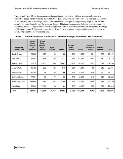
Beaver Lake <strong>SWAT</strong> <strong>Model</strong>ing Baseline Analysis February 12, 2009Table 9 and Table 10 list the acreages and percentages, respectively of land uses in each reportingwatershed based on the planning maps for 2055. [The total area listed in Table 9 is less than that shownin the existing land use acreage table ( Table 1) because the edges of the planning maps do not extend<strong>com</strong>pletely to the boundary of the watershed area. This issue was addressed during post processing asexplained below.] The percent of forest and grassland under this initial estimate of future land use dropsto 21.4 percent and 2.2 percent, respectively. Low density urban development is assumed to <strong>com</strong>prisenearly 70 percent of the watershed area.Table 9.Initial Estimates of Future (2055) Land Use Acreages for Beaver Lake WatershedReportingWatershedUrbanResidentialLowDensityUrbanResidentialHighDensityWaterAgricultureRangeland/BrushForestPastureBermudaGrassPastureFescueTotalBrush Creek 25,853 107 89 85 234 1,362 351 393 28,474East Fork 55,863 675 198 433 1,743 64,251 1,481 1,469 126,112Beaver Lake 86,216 3,158 859 25,047 3,739 30,613 2,803 312 152,746Lower White 16,782 592 126 543 324 1,349 405 610 20,731Middle Fork 30,789 54 94 66 803 15,515 806 990 49,117Richland Creek 77,891 89 77 55 717 12,003 716 813 92,362War Eagle Creek 181,608 749 307 1,200 1,665 24,242 1,985 1,674 213,430West Fork 55,656 7,181 88 164 768 13,403 705 1,047 79,013Total 530,657 12,605 1,837 27,593 9,993 162,738 9,252 7,308 761,98530