SWAT Model Recalibration - Tetratech-ffx.com
SWAT Model Recalibration - Tetratech-ffx.com
SWAT Model Recalibration - Tetratech-ffx.com
- No tags were found...

You also want an ePaper? Increase the reach of your titles
YUMPU automatically turns print PDFs into web optimized ePapers that Google loves.
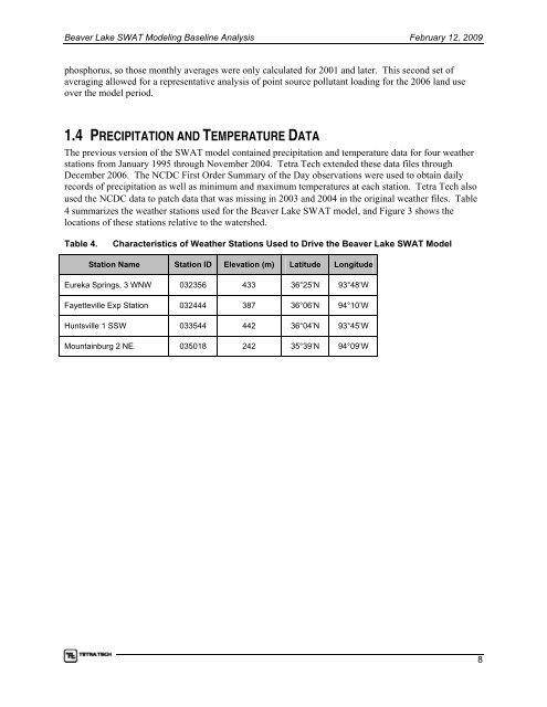
Beaver Lake <strong>SWAT</strong> <strong>Model</strong>ing Baseline Analysis February 12, 2009phosphorus, so those monthly averages were only calculated for 2001 and later. This second set ofaveraging allowed for a representative analysis of point source pollutant loading for the 2006 land useover the model period.1.4 PRECIPITATION AND TEMPERATURE DATAThe previous version of the <strong>SWAT</strong> model contained precipitation and temperature data for four weatherstations from January 1995 through November 2004. Tetra Tech extended these data files throughDecember 2006. The NCDC First Order Summary of the Day observations were used to obtain dailyrecords of precipitation as well as minimum and maximum temperatures at each station. Tetra Tech alsoused the NCDC data to patch data that was missing in 2003 and 2004 in the original weather files. Table4 summarizes the weather stations used for the Beaver Lake <strong>SWAT</strong> model, and Figure 3 shows thelocations of these stations relative to the watershed.Table 4.Characteristics of Weather Stations Used to Drive the Beaver Lake <strong>SWAT</strong> <strong>Model</strong>Station Name Station ID Elevation (m) Latitude LongitudeEureka Springs, 3 WNW 032356 433 36°25’N 93°48’WFayetteville Exp Station 032444 387 36°06’N 94°10’WHuntsville 1 SSW 033544 442 36°04’N 93°45’WMountainburg 2 NE 035018 242 35°39’N 94°09’W8