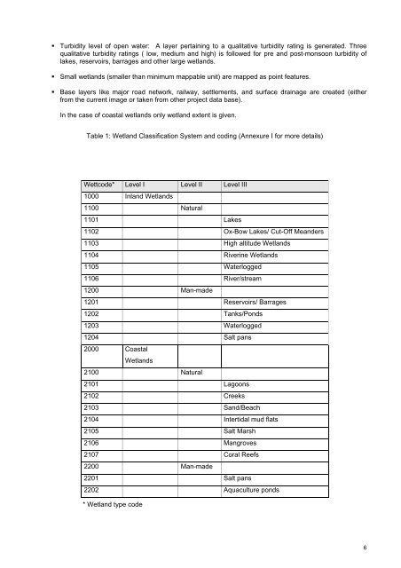
• Turbidity level <strong>of</strong> open water: A layer pertaining to a qualitative turbidity rating is generated. Threequalitative turbidity ratings ( low, medium <strong>and</strong> high) is followed for pre <strong>and</strong> post-monsoon turbidity <strong>of</strong>lakes, reservoirs, barrages <strong>and</strong> other large wetl<strong>and</strong>s.• Small wetl<strong>and</strong>s (smaller than minimum mappable unit) are mapped as point features.• Base layers like major road network, railway, settlements, <strong>and</strong> surface drainage are created (eitherfrom the current image or taken from other project data base).In the case <strong>of</strong> coastal wetl<strong>and</strong>s only wetl<strong>and</strong> extent is given.Table 1: Wetl<strong>and</strong> Classification System <strong>and</strong> coding (Annexure I for more details)Wettcode* Level I Level II Level III1000 Inl<strong>and</strong> Wetl<strong>and</strong>s1100 Natural1101 Lakes1102 Ox-Bow Lakes/ Cut-Off Me<strong>and</strong>ers1103 High altitude Wetl<strong>and</strong>s1104 Riverine Wetl<strong>and</strong>s1105 Waterlogged1106 River/stream1200 Man-made1201 Reservoirs/ Barrages1202 Tanks/Ponds1203 Waterlogged1204 Salt pans2000 CoastalWetl<strong>and</strong>s2100 Natural2101 Lagoons2102 Creeks2103 S<strong>and</strong>/Beach2104 Intertidal mud flats2105 Salt Marsh2106 Mangroves2107 Coral Reefs2200 Man-made2201 Salt pans2202 Aquaculture ponds* Wetl<strong>and</strong> type code6
3.0 STUDY AREA<strong>Meghalaya</strong> occupies the western position <strong>of</strong> the North eastern region. The North Eastern state <strong>of</strong> <strong>Meghalaya</strong>theabode <strong>of</strong> clouds is predominantly a l<strong>and</strong> <strong>of</strong> hills <strong>and</strong> valley. Owing to its natural beauty <strong>and</strong> grace it hasbeen also named as ‘Scotl<strong>and</strong> <strong>of</strong> the East’. Geographical location <strong>of</strong> the state is between 89 o 45’ to 92 o 48’<strong>and</strong> 25 o 02’ to 26 o 05’. The total geographical area <strong>of</strong> the state is 22, 429 Sq Km, extending 300 km west toeast <strong>and</strong> 100 km from north to south.It is bounded on the north by Goalpara <strong>and</strong> Kamrup district <strong>of</strong> Assam, on the east by North Cachar <strong>and</strong> KarbiAnglong, the Western <strong>and</strong> Southern boundary is the International border between India <strong>and</strong> Bangladesh. Theprevailing climate in the state is characterized by heavy rainfall, which favors the action <strong>of</strong> streams to aconsiderable extent.The geological formations, its resultant topography <strong>and</strong> tendency <strong>of</strong> headword erosion by rain water havelead to the creation <strong>of</strong> drainage network in <strong>Meghalaya</strong>. The state is blessed with number <strong>of</strong> perennial rivers.The principal rivers <strong>of</strong> the state run either a Northerly or Southerly direction. Satellite imagery identifies theadaptation <strong>of</strong> streams along major <strong>and</strong> minor lineaments. The rivers flowing towards the north to meet mightyBrahmaputra river <strong>of</strong> Assam plain have gentle gradient <strong>of</strong> longitudinal pr<strong>of</strong>iles <strong>and</strong> thereby do not form anymajor waterfalls <strong>and</strong> deep gorges. The rivers flowing towards the south are characterized by steepestgradient <strong>and</strong> abruptly falls to the Bangladesh plain.The capital <strong>of</strong> <strong>Meghalaya</strong> state is in Shillong. There are total seven districts <strong>of</strong> <strong>Meghalaya</strong> state. The districtsderive their names from that <strong>of</strong> the tribes inhabiting the region. The seven districts are: East Khasi hills, Eastgaro hills, Jaintia hills, Ri Bhoi, South Garo hills,West Garo hills <strong>and</strong> West Khasi hills (Statistical h<strong>and</strong> book <strong>of</strong><strong>Meghalaya</strong>, 2007) . There are about 5,782 villages in the state. The total population <strong>of</strong> the state is 2,318, 822(Manorama year book 2009).The major rivers <strong>of</strong> the state are Ganol, Ringgi, Krishnai, M<strong>and</strong>a, Darong, Bhogai, simsang, Dareng, Umkhri,Umtrew, Umiam, Kopili, Kynshiang,Shella, Umngot, Myntdu, Lubha, etc. One <strong>of</strong> the marked features <strong>of</strong> RiverKynshi in West Khasi Hills is the formation <strong>of</strong> River Isl<strong>and</strong> called Nongkhnum. Nongkhnum is not only India’sbut Asia’s second largest river isl<strong>and</strong>. Ranikor situated in the West Khasi Hills district in the confluence <strong>of</strong>Kynshi <strong>and</strong> Rilang rivers is one <strong>of</strong> the best fishing spots. <strong>Meghalaya</strong> has the highest hydro – electric potentialin the north-eastern region second only to Auranachal Pradesh. Hydel projects such as Umiam <strong>and</strong> Umtrewhave caused construction <strong>of</strong> artificial lakes for the generation <strong>of</strong> electricity. Umiam Lake commonly calledBarapani is formed by the damming <strong>of</strong> the Umiam river under the Umiam Hydro-Electric Project is a place <strong>of</strong>major tourist attraction <strong>and</strong> has great potentialities <strong>of</strong> recreation, aquatic sports, fishing etc. <strong>Meghalaya</strong> is alsonoted for a number <strong>of</strong> river cataracts <strong>and</strong> waterfall <strong>of</strong> great beauty located at different heights <strong>and</strong> scenicsetting.The state is covered by 54 Survey <strong>of</strong> India topographical maps on 1:50,000 scale that spatial framework formapping (Figure 4). The spatial framework was prepared using 15’x15’ grid.7