

Meghalaya - Ministry of Environment and Forests
Meghalaya - Ministry of Environment and Forests
Meghalaya - Ministry of Environment and Forests
- No tags were found...

You also want an ePaper? Increase the reach of your titles
YUMPU automatically turns print PDFs into web optimized ePapers that Google loves.
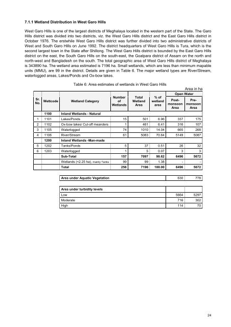
7.1.1 Wetl<strong>and</strong> Distribution in West Garo HillsWest Garo Hills is one <strong>of</strong> the largest districts <strong>of</strong> <strong>Meghalaya</strong> located in the western part <strong>of</strong> the State. The GaroHills district was divided into two districts, viz. the West Garo Hills district <strong>and</strong> the East Garo Hills district inOctober 1976. The erstwhile West Garo Hills district was further divided into two administrative districts <strong>of</strong>West <strong>and</strong> South Garo Hills on June 1992. The district headquarters <strong>of</strong> West Garo Hills is Tura, which is thesecond largest town in the State after Shillong. The West Garo Hills district is bounded by the East Garo Hillsdistrict on the east, the South Garo Hills on the south-east, the Goalpara district <strong>of</strong> Assam on the north <strong>and</strong>north-west <strong>and</strong> Bangladesh on the south. The total geographic area <strong>of</strong> West Garo Hills district <strong>of</strong> <strong>Meghalaya</strong>is 343890 ha. The wetl<strong>and</strong> area estimated is 7196 ha. Small wetl<strong>and</strong>s, which are less than minimum mapableunits (MMU), are 99 in the district. Details are given in Table 6. The major wetl<strong>and</strong> types are River/Stream,waterlogged areas, Lakes/Ponds <strong>and</strong> Ox-bow lakes.Sr.No.WettcodeTable 6: Area estimates <strong>of</strong> wetl<strong>and</strong>s in West Garo HillsWetl<strong>and</strong> CategoryNumber<strong>of</strong>Wetl<strong>and</strong>sTotalWetl<strong>and</strong>Area% <strong>of</strong>wetl<strong>and</strong>areaOpen WaterPostmonsoonAreaArea in haPremonsoonArea1100 Inl<strong>and</strong> Wetl<strong>and</strong>s - Natural1 1101 Lakes/Ponds 15 501 6.96 337 1752 1102 Ox-bow lakes/ Cut-<strong>of</strong>f me<strong>and</strong>ers 1 461 6.41 316 1073 1105 Waterlogged 74 1010 14.04 665 2684 1106 River/Stream 61 5083 70.64 5149 50871200 Inl<strong>and</strong> Wetl<strong>and</strong>s -Man-made5 1202 Tanks/Ponds 5 37 0.51 26 326 1203 Waterlogged 1 5 0.07 3 3Sub-Total 157 7097 98.62 6496 5672Wetl<strong>and</strong>s (


