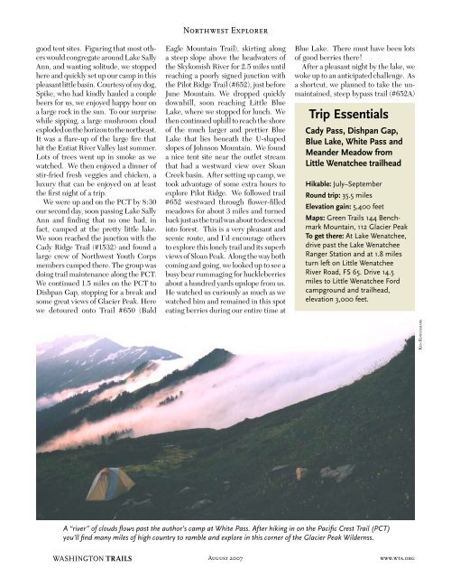
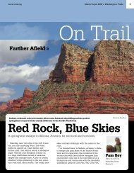
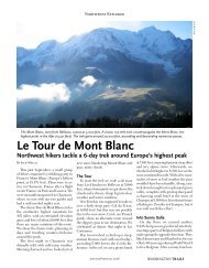
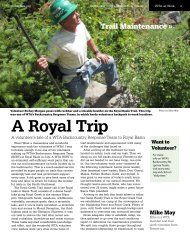
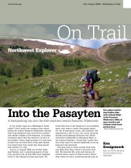
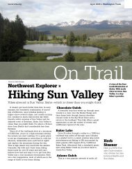
good tent sites. Figuring that most o<strong>the</strong>rswould congregate around Lake SallyAnn, and wanting solitude, we stoppedhere and quickly set up our camp in thispleasant little basin. Courtesy of my dog,Spike, who had kindly hauled a couplebeers for us, we enjoyed happy hour ona large rock in <strong>the</strong> sun. To our surprisewhile sipping, a large mushroom cloudexploded on <strong>the</strong> horizon to <strong>the</strong> nor<strong>the</strong>ast.It was a flare-up of <strong>the</strong> large fire thathit <strong>the</strong> Entiat River Valley last summer.Lots of trees went up in smoke as wewatched. We <strong>the</strong>n enjoyed a dinner ofstir-fried fresh veggies and chicken, aluxury that can be enjoyed on at least<strong>the</strong> first night of a trip.We were up and on <strong>the</strong> PCT by 8:30our second day, soon passing Lake SallyAnn and finding that no one had, infact, camped at <strong>the</strong> pretty little lake.We soon reached <strong>the</strong> junction with <strong>the</strong>Cady Ridge Trail (#1532) and found alarge crew of Northwest Youth Corpsmembers camped <strong>the</strong>re. The group wasdoing trail maintenance along <strong>the</strong> PCT.We continued 1.5 miles on <strong>the</strong> PCT toDishpan Gap, stopping for a break andsome great views of Glacier Peak. Herewe detoured onto Trail #650 (BaldNorthwest ExplorerEagle Mountain Trail), skirting alonga steep slope above <strong>the</strong> headwaters of<strong>the</strong> Skykomish River for 2.5 miles untilreaching a poorly signed junction with<strong>the</strong> Pilot Ridge Trail (#652), just beforeJune Mountain. We dropped quicklydownhill, soon reaching Little BlueLake, where we stopped for lunch. We<strong>the</strong>n continued uphill to reach <strong>the</strong> shoreof <strong>the</strong> much larger and prettier BlueLake that lies beneath <strong>the</strong> U-shapedslopes of Johnson Mountain. We founda nice tent site near <strong>the</strong> outlet streamthat had a westward view over SloanCreek basin. After setting up camp, wetook advantage of some extra hours toexplore Pilot Ridge. We followed trail#652 westward through flower-filledmeadows for about 3 miles and turnedback just as <strong>the</strong> trail was about to descendinto forest. This is a very pleasant andscenic route, and I’d encourage o<strong>the</strong>rsto explore this lonely trail and its superbviews of Sloan Peak. Along <strong>the</strong> way bothcoming and going, we looked up to see abusy bear rummaging for huckleberriesabout a hundred yards upslope from us.He watched us curiously as much as wewatched him and remained in this spoteating berries during our entire time atBlue Lake. There must have been lotsof good berries <strong>the</strong>re!After a pleasant night by <strong>the</strong> lake, wewoke up to an anticipated challenge. Asa shortcut, we planned to take <strong>the</strong> unmaintained,steep bypass trail (#652A)Trip EssentialsCady Pass, Dishpan Gap,Blue Lake, White Pass andMeander Meadow fromLittle Wenatchee trailheadHikable: July–SeptemberRound trip: 35.5 milesElevation gain: 5,400 feetMaps: Green <strong>Trails</strong> 144 BenchmarkMountain, 112 Glacier PeakTo get <strong>the</strong>re: At Lake Wenatchee,drive past <strong>the</strong> Lake WenatcheeRanger Station and at 1.8 milesturn left on Little WenatcheeRiver Road, FS 65. Drive 14.5miles to Little Wenatchee Fordcampground and trailhead,elevation 3,000 feet.Ken KonigsmarkA “river” of clouds flows past <strong>the</strong> author’s camp at White Pass. After hiking in on <strong>the</strong> Pacific Crest Trail (PCT)you’ll find many miles of high country to ramble and explore in this corner of <strong>the</strong> Glacier Peak Wildernss.WASHINGTON TRAILS August 2007 www.wta.org
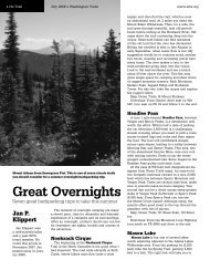
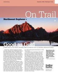
Northwest Explorerthat climbs up <strong>the</strong> slope to <strong>the</strong> south ofBlue Lake and crosses Peak 6562 to intersectback with <strong>the</strong> Bald Eagle MountainTrail (#650) that we’d taken <strong>the</strong> priorday. Instead of a 3.5-mile trip back to<strong>the</strong> PCT, this would cut <strong>the</strong> distance toonly 2 miles. But we would be paying aprice in steep climbing. As it turned outthis was well worth it. The bypass trailwas a bit rocky and steep in places, but<strong>the</strong> scenery it provided, particularly uponreaching <strong>the</strong> crest, was worth every dropof sweat. We paused at <strong>the</strong> crest to catchour breath, to take pictures, and to baskin <strong>the</strong> scenery. I would again encourageo<strong>the</strong>rs to try this if so inclined.We were soon back on <strong>the</strong> PCT atDishpan Gap after our day’s detourloop and again headed north. Thisstretch of <strong>the</strong> PCT offers some of <strong>the</strong>best country to be found anywhere; it’sall above treeline and wanders throughlush meadows, with rugged mountainscenery in all directions. Looking downon Meander <strong>Meadows</strong>, rounding <strong>the</strong>shoulder of Kodak Peak, dropping toIndian Pass, <strong>the</strong>n Kid Pond… all broughtback memories of 15 years earlier.We kept going all <strong>the</strong> way to WhitePass, with some difficulty finding wateralong <strong>the</strong> way. At <strong>the</strong> pass, a campingarea lies just below and west of <strong>the</strong> PCT.However, <strong>the</strong>re were already severalgroups <strong>the</strong>re, so we chose to turn easton an unmapped, un-maintained trailthat branches off <strong>the</strong> PCT at <strong>the</strong> passand heads east towards a basin we couldsee in <strong>the</strong> distance. We found a flowingstream <strong>the</strong>re, a grassy tent site, and ledgetopviews south to Indian Peak.After setting up camp, and curiousabout where <strong>the</strong> faint trail led, wecontinued walking for 2.5 miles almostto <strong>the</strong> edge of White Chuck Glacier.We wondered if this could be a bypassroute for PCT thru-hikers to cut across<strong>the</strong> sou<strong>the</strong>rn fringe of Glacier Peak anddown to <strong>the</strong> Suiattle River trail; for thosewho wanted a shorter and more directroute than <strong>the</strong> established bypass thatfollows Indian Creek trail. In any case,it was a scenic side trip. I climbed to <strong>the</strong>top of peak 7987 (listed as such on <strong>the</strong>Green <strong>Trails</strong> map) to get a 360-degreeview. I was shocked upon reaching <strong>the</strong>top to look down into <strong>the</strong> White ChuckGlacier basin and see how little snowand ice remained compared to what Iremembered from 15 years earlier. Wehad climbed up and explored <strong>the</strong> basinin September at that time and foundlarge areas of snow and ice. Now, evena month earlier in <strong>the</strong> year, it was mostlyrock. Ano<strong>the</strong>r sign of global warming?As we returned to camp, clouds beganThe author’s trusty dog Spike amidfalse hellebore, near White Pass.to form and spill over <strong>the</strong> edge of WhiteMountain. We expected worse wea<strong>the</strong>r<strong>the</strong> next day.For some reason I woke up at 5 a.m.and as I stepped outside was greeted byone of <strong>the</strong> most amazing natural wondersI’ve ever seen. I stood just above anunending, fast-moving “river of clouds”that was flowing up and over White Passlike a tsunami of gray. To <strong>the</strong> east, o<strong>the</strong>rclouds flowed across <strong>the</strong> ridgeline anddropped into <strong>the</strong> White River basin. Wewere in an island of open sky surroundedby rivers of churning clouds flowing over<strong>the</strong> ridgelines around us. I climbed up<strong>the</strong> slope of White Mountain and just sat<strong>the</strong>re for a couple of hours to absorb <strong>the</strong>beauty of it all, with <strong>the</strong> clouds changingcolor and form as <strong>the</strong> sun rose. AfterKeith woke up, he joined me to climbto <strong>the</strong> top of White Mountain where, insunshine, we were on top of <strong>the</strong> worldKen Konigsmarklooking down on <strong>the</strong> fast-moving riverof clouds.We enjoyed that respite, knowingthat we soon needed to pack up andbegin backtracking south on <strong>the</strong> PCT,right into <strong>the</strong> middle of <strong>the</strong> “river.” Aswe expected, <strong>the</strong> clouds held rain, and<strong>the</strong> poor souls who had camped below<strong>the</strong> PCT were stuck in <strong>the</strong> drippy wetnessof it. We found that <strong>the</strong> cloudsdissipated soon after rolling over <strong>the</strong>crest so as we walked along <strong>the</strong> PCTwe would weave in and out of cloudsand sprinkles depending on which sideof <strong>the</strong> crest we were on. We had hopedto spend a final night near Kodak Peak,but found drippy clouds still hugging<strong>the</strong> slopes here while fur<strong>the</strong>r below wecould see Meander <strong>Meadows</strong> in brightsunshine. We opted to take <strong>the</strong> LittleWenatchee River Trail (#1525) downto <strong>the</strong> meadows as our route back to<strong>the</strong> trailhead. We intended to camp atMeander <strong>Meadows</strong>, but found severalgroups already in established camps.So we decided to continue on, hopingto find a campsite along <strong>the</strong> trail. Well,that plan didn’t work; in fact we foundno suitable campsite anywhere as wecontinued plodding along—ultimately,all <strong>the</strong> way back to <strong>the</strong> trailhead. Wealso found that this trail, unlike <strong>the</strong> CadyCreek Trail, had been heavily rutted andpounded by horse traffic, thus generatinghuge dust clouds with every step. Thetrail is also steep, very brushy in manysections, and just plain unpleasant.Avoid it if possible, especially if goinguphill. The o<strong>the</strong>r routes into this areaare much better.After what seemed like an unending15-mile, dust-clogged journey, we finallyreached <strong>the</strong> trailhead where we’d begun.With side trips, we figured we coveredalmost 50 miles in a four-day period,seeing some of <strong>the</strong> best of <strong>the</strong> GlacierPeak Wilderness. With <strong>the</strong> 2006 winterstorm damage it’s unknown if this sametrip is even possible at present (see tripreport on page 37). For those seekinga moderately strenous, scenery-filled,multi-day trip, this is a great option. Ken Konigsmark is a WTA advisoryboard member from Issaquah.www.wta.orgAugust 2007WASHINGTON TRAILS