

Dreeite NCR Management Statement (PDF File 2.2 ... - Parks Victoria
Dreeite NCR Management Statement (PDF File 2.2 ... - Parks Victoria
Dreeite NCR Management Statement (PDF File 2.2 ... - Parks Victoria

Create successful ePaper yourself
Turn your PDF publications into a flip-book with our unique Google optimized e-Paper software.
<strong>Dreeite</strong> Nature Conservation Reserve<strong>Management</strong> <strong>Statement</strong>Land Stewardship & BiodiversityDepartment of Sustainability and EnvironmentMay 2005
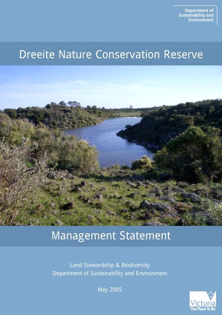
This <strong>Management</strong> <strong>Statement</strong> has been written by Hugh Robertson and JamesFitzsimons for the Department of Sustainability and Environment, <strong>Victoria</strong>.This <strong>Statement</strong> fulfils obligations by the State of <strong>Victoria</strong> to the Commonwealth ofAustralia, which provided financial assistance for the purchase of this reserve underthe National Reserve System program of the Natural Heritage Trust.©The State of <strong>Victoria</strong> Department of Sustainability and Environment 2005This publication is copyright. No part may be reproduced by any process except inaccordance with the provisions of the Copyright Act 1968.ISBN 1 74152 140 8Disclaimer:This publication may be of assistance to you but the State of <strong>Victoria</strong> and itsemployees do not guarantee that the publication is without flaw of any kind or iswholly appropriate for your particular purposes and therefore disclaims all liabilityfor any error, loss or other consequence which may arise from you relying on anyinformation in this publication.Cover:Permanent wetland surrounded by Stony Knoll Shrubland, <strong>Dreeite</strong> NatureConservation Reserve (Photo: James Fitzsimons).
<strong>Dreeite</strong> Nature Conservation ReserveObjectivesThis <strong>Management</strong> <strong>Statement</strong> for the <strong>Dreeite</strong> Nature Conservation Reserve outlinesthe reserve’s natural values and the directions for its management in the short tolong term.The overall operational management objective is:Maintain, and enhance where appropriate, the condition of the reserve whileallowing natural processes of regeneration, disturbance and succession to occur andactively initiating these processes where required.Background and ContextReason for purchaseSince the implementation of the National Reserve System Program (NRS) in 1992, allAustralian states and territories have been working toward the development of acomprehensive, adequate and representative (CAR) system of protected areas.In a systematic process to increase the reservation levels of <strong>Victoria</strong>’s mostthreatened ecosystems, the Department of Sustainability and Environment’sconservation land purchase program aims to acquire areas of private land containinghigh quality samples of such ecosystems for addition to the reserve system.A strategic assessment of high quality sites containing threatened ecosystems on the<strong>Victoria</strong>n Volcanic Plain Bioregion was completed in 1999 (Ross 1999). Among anumber of sites identified as suitable for voluntary purchase and addition to theprotected area estate, the Stony Knoll Shrubland and wetlands at <strong>Dreeite</strong> werepurchased due to their good condition and position within a larger area containingthis vegetation type.The purchase was assisted with funding from the National Reserve System Programof the Commonwealth Government’s Natural Heritage Trust (Project No. N457).The <strong>Dreeite</strong> Stony Knoll Shrubland and wetlands fall within the <strong>Victoria</strong>n VolcanicPlain IBRA 5.1 bioregion (Environment Australia 2000) and the Corangamite EastLocal Landscape Zone (Ross et al. 2003).LocationThe <strong>Dreeite</strong> Nature Conservation Reserve (<strong>Dreeite</strong> <strong>NCR</strong>) of 54.05 ha is located offHay’s Road approximately 2 km NNE of <strong>Dreeite</strong> and approximately 4.5 km from theeastern shoreline of Lake Corangamite (Figure 1). It consists of: Crown Allotment2001, Parish of Cundare. Purchase of the <strong>Dreeite</strong> property was completed on 9 July2004. The land was transferred to the Crown on 29 July 2004 and assigned to <strong>Parks</strong><strong>Victoria</strong> for management on 21 January 2005.Reservation StatusThe <strong>Dreeite</strong> <strong>NCR</strong> is temporarily reserved for the “preservation of an area ofecological significance” under the Crown Land (Reserves) Act 1978 and managed as aNature Conservation Reserve.1
<strong>Dreeite</strong> Nature Conservation ReserveThe generic management objectives for Nature Conservation Reserves as defined by <strong>Parks</strong><strong>Victoria</strong> (2003) are:Nature conservation reserves a) conserve and protect species, communities andhabitats of indigenous plants, animals and other organisms; b) provide for researchand study of the natural environment of the reserve where this is consistent with a)and there is minimal impact on the reserve; c) provide opportunities for appropriateenjoyment and recreation and education by the public where this does not conflictwith a); d) protect Aboriginal cultural sites and places; and e) protect historic featuresin specific reserves where noted.Nature Conservation Reserves are consistent with IUCN Protected Area Category Ia:Strict Nature Reserve (NRE 1996).As the purchased land was originally freehold, no Land Conservation Council(LCC), Environment Conservation Council (ECC) or <strong>Victoria</strong>n EnvironmentalAssessment Council (VEAC) recommendations apply.The Crown Land (Reserves) (Nature Conservation Reserve) Regulations 2004 will apply toactivities in this reserve when it is listed under the Schedule of the Regulations.Natural Values and ConditionRefer to Figure 2 for the location of threatened species recorded in the Atlas of<strong>Victoria</strong>n Wildlife and the Flora Information System 1 .Vegetation TypesAlthough the <strong>Dreeite</strong> <strong>NCR</strong> and surrounding region are mapped as containing StonyRises Woodland (Figure 2), ground-truthing has revealed that Stony Knoll ShrublandEcological Vegetation Class (EVC) dominates most of the reserve 2 (Ross 1999). StonyKnoll Shrubland is considered endangered in the <strong>Victoria</strong>n Volcanic Plain bioregion(Taylor et al. 2003), and patches of the size present in the <strong>Dreeite</strong> area are very rare(Ross 1999). <strong>Dreeite</strong> <strong>NCR</strong> also contains areas of wetland habitat supporting aquaticvegetation (Peterson pers. comm. 2003) 3 . Wetland habitat at sites close to <strong>Dreeite</strong><strong>NCR</strong> is mapped as Plains Sedgy Wetland EVC and Plains Grassy Wetland EVC(Figure 2). The reserve also contains some small areas dominated by exotic pasturegrasses and herbs that are of low conservation value. The condition of the vegetationin the reserve was assessed in March 2003 using the DSE Habitat Hectares method,and is considered to be in medium-good condition (scored 59/100 4 ).1Note this does not necessarily represent records for all threatened species on the reserve. Only thoserecorded in the DSE flora and fauna databases are displayed.2Note that as of October 2004,
<strong>Dreeite</strong> Nature Conservation ReserveEcological <strong>Management</strong> of Stony Rises Woodland and WetlandsThe Stony Knoll Shrubland in <strong>Dreeite</strong> <strong>NCR</strong> is in good condition and does not requireactive management at present. Although the understorey vegetation supported anumber of exotic herbs and grasses they do not pose a significant risk to theconservation values of the shrubland.Wetland habitat in <strong>Dreeite</strong> <strong>NCR</strong> is susceptible to degradation from stock entering thewetlands and may require fencing. Altered water regimes and the establishment ofaquatic pest plants may also impact on the wetlands. There is evidence of past rockremoval from wetland and grassland areas, which may have altered the structure ofthe habitat and adversely affected native flora and fauna.Control of plant biomass, particularly of exotic pasture grass species, may beconsidered desirable to provide habitat for native flora and fauna. Ecological burningis often used as a management tool to control exotic pasture species and promote theregeneration of indigenous flora. However, due to the high fuel loads associatedwith the shrubs and trees in <strong>Dreeite</strong> <strong>NCR</strong> and on adjacent private property,ecological burning is not recommended.<strong>Dreeite</strong> <strong>NCR</strong> has been grazed by sheep historically, but more recently cattle haveutilised the property. Although grazing may have caused degradation to wetlandvegetation, strategic grazing may be required to remove the biomass of plants,particularly exotic plants, with stocking rates adjusted to suit climatic conditionsand/or pest plant abundance. Whilst the use of sheep for grazing is more desirabledue to their lesser impact on the ecosystem, cattle grazing is the main landuse in thearea and thus may be the only practical option.<strong>Management</strong> objectives and targets (short-long term)- Actively manage the <strong>Dreeite</strong> <strong>NCR</strong> using some of the management optionsdescribed above to maintain the condition, species diversity and structuralheterogeneity of the vegetation.- Limit stock access to wetland and saltmarsh areas of <strong>Dreeite</strong> <strong>NCR</strong> throughestablishment of internal fencing and liaison with adjoining landholders.- Monitor outcomes of management actions and adapt management regimes as theneed arises.- Encourage ongoing research by universities and other scientific institutions intooptimal management techniques for maintaining and enhancing Stony KnollShrubland biodiversity.Flora<strong>Dreeite</strong> <strong>NCR</strong> supports the Stony Knoll Shrubland EVC dominated by Tree VioletHymenanthera dentata, with sparse Blackwood Acacia melanoxylon and Black WattleAcacia mearnsii, while the permanent and semi-permanent wetlands support sedge,and other aquatic vegetation communities (Peterson pers. comm. 2003).Refer to Appendix 1 for flora records from <strong>Dreeite</strong> <strong>NCR</strong> and adjoining areas.3
<strong>Dreeite</strong> Nature Conservation Reserve<strong>Management</strong> objectives and targets (short-medium term)- Record flora in the <strong>Parks</strong> <strong>Victoria</strong> Environmental Information System and theDSE Flora Information System (FIS), and encourage seasonal survey programs.Fauna<strong>Dreeite</strong> <strong>NCR</strong> contains permanent wetlands, rocky outcrops, and extensive areas ofStony Knoll Shrubland, which provide diverse habitat for fauna. The reserveprovides known habitat for the nationally significant 5 Corangamite Water SkinkEulamprus tympanum marnieae and Growling Grass Frog Litoria raniformis, and anumber of threatened water bird species. Major threats to the Corangamite WaterSkink are habitat loss and fragmentation, degradation of remaining habitat (e.g.through weed invasion) and the impacts of introduced animals, including predation(Robertson 1998). <strong>Dreeite</strong> <strong>NCR</strong> is one of only 14 sites where the Corangamite WaterSkink has been observed over the past four years, increasing the number of reservedsites to seven (Peterson pers. comm. 2003). Five other species of frogs, including thegreen morph of Southern Brown Tree Frog Litoria ewingii have also been recorded in<strong>Dreeite</strong> <strong>NCR</strong> (Peterson 2003). <strong>Dreeite</strong> <strong>NCR</strong> has also been identified as a potential sitefor the reintroduction of the critically endangered Eastern Barred BandicootPerameles gunnii (Peterson pers. comm 2003).Significant bird species recorded in <strong>Dreeite</strong> <strong>NCR</strong> include Brolga Grus rubicunda,Lewin’s Rail Rallus pectoralis, Freckled Duck Stictonetta naevosa, Australasian ShovelerAnas rhynchotis, Latham’s Snipe Gallinago hardwickii and Whiskered Tern Chlidoniashybridus (Peterson pers. comm. 2003).Refer to Appendix 2 for fauna records from <strong>Dreeite</strong> <strong>NCR</strong>.<strong>Management</strong> objectives and targets (short-medium term)- Record fauna in the <strong>Parks</strong> <strong>Victoria</strong> Environmental Information System and theAtlas of <strong>Victoria</strong>n Wildlife, and encourage seasonal survey programs.Biosites 6Three Biosites are recorded near <strong>Dreeite</strong> <strong>NCR</strong>, these are:- Site # 637 ‘Beeac/<strong>Dreeite</strong> Rd’ (State significance) (Located approximately 1 kmnorth of the <strong>Dreeite</strong> <strong>NCR</strong>)- Site # 718 ‘Beeac-<strong>Dreeite</strong> Road - BROLGA 101’ (National Significance) (Locatedapproximately 3 km southeast of <strong>Dreeite</strong> <strong>NCR</strong>)- Site # 653 ‘Pipe Clay Lake’ (State significance) (Located approximately 3 kmnortheast of <strong>Dreeite</strong> <strong>NCR</strong>)Refer to Appendix 3 for further details.5Threat status for flora and fauna follows DSE (2003, 2005)6‘Biosites’ are sites of biological conservation significance and their location and details are maintainedon a register by the Department of Sustainability and Environment.4
<strong>Dreeite</strong> Nature Conservation ReserveLandscape context<strong>Dreeite</strong> <strong>NCR</strong> represents one of the largest areas of Stony Knoll Shrubland reservedfor conservation in the region. The surrounding landscape is characterised byundulating stony rises, small freshwater and saline wetlands, and large saline lakesincluding a number of lakes included in the Western District Lakes Ramsar site (NRE2002). <strong>Dreeite</strong> <strong>NCR</strong> is bordered to the west by Hay’s Road and bordered to the north,east and south by private property, most of which also contains Stony KnollShrubland and wetlands (Figure 4). Given the significance of habitat on adjoiningand nearby property, options to expand or enhance the existing reserve, throughland purchase or covenanting should be investigated.Other nearby reserves in the bioregion include Lake Cundare and Lake BeeacWildlife Reserves, and the Lake Corangamite, Cundare, Beeac Swamp and CundarePool Lake Reserves (Figure 3). Grazing is the predominant land use in the area (Rosset al. 2003).Threatening ProcessesPest plantsPest plants are considered a moderate threat to the conservation values of the <strong>Dreeite</strong><strong>NCR</strong>. A ‘Habitat Hectares’ assessment of <strong>Dreeite</strong> <strong>NCR</strong> (March 2003) noted thereserve is moderately impacted by weeds. Weed cover is generally high in areaswhere there are no shrubs present. Ongoing pest plant control is recommended tocontrol pasture grasses (e.g. Bromus spp. and Vulpia spp.) and other weed species thathave the ability to alter the structure of the vegetation and pose a threat to speciesreliant on the ecosystem. Hemlock Conium maculatum and Thistles (Sonchus spp. andCirsium spp.) have been observed in the reserve.<strong>Management</strong> objectives and targets (short-long term)- Control the establishment and spread of pest plants, particularly exotic pasturegrasses, and encourage the establishment of native plant species in their placethrough grazing and other management techniques.- Liaise with Corangamite Shire and surrounding landowners to ensure control ofenvironmental weeds that occur along Hay’s Road adjoining <strong>Dreeite</strong> <strong>NCR</strong>, toprevent their spread into the reserve.Pest animalsFoxes are present throughout the district, but the impact of predation on nativefauna in the reserve is unknown. However, they may pose a significant threat tosmall mammals, ground nesting or feeding birds, and reptiles, including theCorangamite Water Skink (Robertson 1998). Rabbits are likely to be present in<strong>Dreeite</strong> <strong>NCR</strong> but the impact of rabbits in the reserve is also undetermined.<strong>Management</strong> objectives and targets (short-long term)- Control foxes to maintain habitat values of the reserve for small mammals,reptiles and other ground-dwelling fauna.- Maintain rabbit numbers at less than 5 per spotlight km.5
<strong>Dreeite</strong> Nature Conservation ReservePhysical AssetsNo dams occur in <strong>Dreeite</strong> <strong>NCR</strong>, although the permanent and temporary wetlandsmay provide stock access to water. Alternative arrangements to provide stock accessto water may be necessary to protect the wetlands from degradation. All boundaryfencing at the reserve is in a serviceable condition, and there are no internal fences. Agate situated along Hay’s Road provides access to <strong>Dreeite</strong> <strong>NCR</strong> (Figure 1).<strong>Management</strong> objectives and targets (short-medium term)- Consider fencing off the permanent and temporary wetlands in <strong>Dreeite</strong> <strong>NCR</strong> toprotect the wetlands from degradation by stock. Alternative arrangements toprovide stock access to water will need to be investigated if grazing is used formanagement.- Survey the existing fencing at <strong>Dreeite</strong> <strong>NCR</strong>, and liaise with adjoining landownersto ensure boundary fences are maintained in a stock-proof condition.Heritage Values, Condition and RiskThere are no recorded places of heritage value and there is no evidence of placeswith heritage value.<strong>Management</strong> objectives and targets (short-medium term)- If sites are of heritage value are identified in <strong>Dreeite</strong> <strong>NCR</strong>, assess their conditionand establish management objectives.Indigenous Values, Condition and RiskA fish trap adjacent to the permanent wetland, and non-local rock, which wereidentified in <strong>Dreeite</strong> <strong>NCR</strong> following site inspection are likely to be of indigenoussignificance (J. Clarke pers. comm. 2004). The potential for more places or objects ofindigenous value to be present was considered high. Rock removal, stock tramplingand general site disturbance are identified as risks to the indigenous values of thesefeatures.<strong>Management</strong> objectives and targets (short-long term)- Respect the aspirations and rights of the Kirrae wurrong and FramlinghamAboriginal Trust in managing the reserve in accordance with relevant legislationand <strong>Parks</strong> <strong>Victoria</strong>’s operational policies.- Work together with the Kirrae wurrong with Framlingham Aboriginal Trust tosurvey <strong>Dreeite</strong> <strong>NCR</strong> to identify the location of Indigenous sites, places andobjects.- If sites, places and objects are identified, assess their condition and seek guidancefrom these communities on future management.Visitor Services, Condition and RiskThere is currently no level of visitor services for <strong>Dreeite</strong> <strong>NCR</strong> (classified as “VeryBasic”). The provisional future level of service will be “Very Basic” (no facilities).Access is currently restricted to pedestrian access off Hay’s Road, via Beeac-<strong>Dreeite</strong>6
<strong>Dreeite</strong> Nature Conservation ReserveRoad. While there is no data available, visitor numbers to the <strong>Dreeite</strong> wetland <strong>NCR</strong>are likely to be low (0-5000 p.a.) as the reserve has only been recently purchased.<strong>Management</strong> objectives and targets (short-long term)- Retain “Very Basic” level of service; i.e. do not provide built facilities or accessroads accessible by the general public.- Maintain existing internal <strong>Management</strong> Vehicle Only (MVO) tracks whererequired.Signage: Provide locality signage for the reserve within two years and maintain it.ConsultationThis <strong>Management</strong> <strong>Statement</strong> has been prepared in consultation with Rob Wallis,John Clarke and Evan McDowell (<strong>Parks</strong> <strong>Victoria</strong>).References and Further ReadingDSE (2003) Advisory List of Threatened Vertebrate Fauna in <strong>Victoria</strong> - 2003. Departmentof Sustainability and Environment, Melbourne.DSE (2005) Advisory List of Rare or Threatened Plants in <strong>Victoria</strong> - 2005. Department ofSustainability and Environment, East Melbourne.Environment Australia (2000) Revision of the Interim Biogeographic Regionalisationfor Australia (IBRA) and Development of Version 5.1 Summary Report.Environment Australia, Canberra.http://www.deh.gov.au/parks/nrs/ibra/version5-1/summary-report/index.htmlPeterson, G. N. L. (1999) Distribution and conservation status of the CorangamiteWater Skink (Eulamprus tympanum marnieae) on the <strong>Victoria</strong>n Volcanic Plain.Report to the Research Advisory Group of the Grassy Ecosystem ReferenceGroup, <strong>Parks</strong> <strong>Victoria</strong>, Melbourne. Department of Zoology, La Trobe University,Bundoora. http://www.deh.gov.au/land/publications/water-skink/NRE (2002) Western District Lakes Ramsar Site: Strategic <strong>Management</strong> Plan. Departmentof Natural Resources and Environment, Melbourne.NRE (1996) IUCN Categories and Other Key Data for <strong>Parks</strong> and Conservation Reserves in<strong>Victoria</strong>. National <strong>Parks</strong> and Reserves Branch, National <strong>Parks</strong> Service,Department of Natural Resources and Environment, Melbourne.<strong>Parks</strong> <strong>Victoria</strong> (2003) Conservation Reserves <strong>Management</strong> Strategy. <strong>Parks</strong> <strong>Victoria</strong>,Melbourne.Robertson, P. (1998) Corangamite Water-Skink (Eulamprus tympanum marineae)Recovery Plan 1998-2003. Biodiversity Group, Environment Australia, Canberra.7
<strong>Dreeite</strong> Nature Conservation ReserveRoss, J. (1999) Identification of priority areas for protection and establishment ofprotected areas – <strong>Victoria</strong>n Volcanic Plain. Report for <strong>Parks</strong>, Flora and Fauna,Department of Natural Resources and Environment, Melbourne.Ross, J., Lowe, K.W., Boyle, C. & Moorrees, A. (2003) Biodiversity Action Planning:Landscape Plans for the Eastern zones in the <strong>Victoria</strong>n Volcanic Plain Bioregion.Department of Sustainability and Environment, Melbourne.Taylor, R., Wierzbowski, P., Lowe, K.W., Ross, J., Moorrees, A. & Ahern, L. (2003)Biodiversity Action Planning: Strategic Overview for the <strong>Victoria</strong>n VolcanicPlain Bioregion. Department of Sustainability and Environment, Melbourne.8
<strong>Dreeite</strong> Nature Conservation ReserveAppendix 1: Provisional list of vascular flora recorded at <strong>Dreeite</strong> NatureConservation Reserve and adjoining areas.Taxon Common Name Source1 2Vic StatusFFGEPBCIndigenous SpeciesAcacia mearnsii Black Wattle +Acacia melanoxylon Blackwood +Acaena novae-zelandiae Bidgee-widgee +Carex appressa Tall Sedge +Clematis microphylla Small-leaved Clematis +Crassula sieberiana s.l. Sieber Crassula +Daucus glochidiatus Australian Carrot +Dichondra repens Kidney-weed +Einadia nutans subsp. nutans Nodding Saltbush +Epilobium spp. Willow Herb +Geranium spp. Crane's Bill +Melicytus dentatus s.l. Tree Violet + +Oxalis corniculata s.l. Yellow Wood-sorrel +Phragmites australis Common Reed +Rumex brownii Slender Dock +Senecio pinnatifolius Variable Groundsel +Urtica incisa Scrub Nettle +Introduced SpeciesAcetosella vulgaris Sheep Sorrel +Aira spp. Hair Grass +Arctotheca calendula Cape Weed +Avena barbata Bearded Oat +Briza minor Lesser Quaking-grass +Bromus diandrus Great Brome +Bromus hordeaceus subsp. hordeaceus Soft Brome +Cerastium glomeratum s.l. Common Mouse-ear Chickweed +Cirsium arvense Perennial Thistle +Conium maculatum Hemlock + +Galium aparine Cleavers +Holcus lanatus Yorkshire Fog +Hordeum leporinum Barley-grass +Hypochoeris radicata Cat's Ear +Lycium ferocissimum African Box-thorn +Polycarpon tetraphyllum Four-leaved Allseed +Solanum nigrum sensu Willis (1972) Black Nightshade +Sonchus asper s.l. Rough Sow-thistle +Sonchus oleraceus Common Sow-thistle +Trifolium campestre var. campestre Hop Clover +Trifolium dubium Suckling Clover +Trifolium repens var. repens White Clover +Trifolium subterraneum Subterranean Clover +9
<strong>Dreeite</strong> Nature Conservation ReserveTaxon Common Name Source1 2Vic StatusFFGEPBCVicia spp. Vetch +Vulpia spp. Fescue +Total no. Indigenous spp. 14 4Total no. Introduced spp. 25 1Total no. Species 39 5Key: Threat status follows DSE (2005).Source:1 - <strong>Victoria</strong>n Flora Site Database Ref: M00546, Date: 16 December 1997. Site located on property directlyadjacent (south) of <strong>Dreeite</strong> <strong>NCR</strong>.2 - Incidental flora observations at <strong>Dreeite</strong> <strong>NCR</strong>. Observer: G. Peterson, DPI (Peterson 2003).10
<strong>Dreeite</strong> Nature Conservation ReserveAppendix 2. Provisional list of fauna recorded at <strong>Dreeite</strong> Nature ConservationReserve and adjoining areasCommon Name Scientific Name Source Vict FFG EPBCStatusIndigenous SpeciesBlack Wallaby Wallabia bicolor 1Corangamite Water Skink Eulamprus tympanum marnieae 2 c L EGrowling Grass Frog Litoria raniformis 1,2,4 e L VSpotted Marsh Frog Limnodynastes tasmaniensis 2Southern Brown Tree Frog Litoria ewingii 4Australasian Grebe Tachybaptus novaehollandiae 3Brolga Grus rubicunda 4 v LLewin’s Rail Rallus pectoralis 4 v LFreckled Duck Stictonetta naevosa 4 e LAustralasian Shoveler Anas rhynchotis 4 vLatham’s Snipe Gallinago harwickii 4 nBanded Stilt Cladorhynchus leucocephalus 4Australian Magpie Gymnorhina tibicen 1Australian White Ibis Threskiornis molucca 3Black Swan Cygnus atratus 1,3Black-shouldered Kite Elanus axillaris 2Black-winged Stilt Himantopus himantopus 3Brown Falcon Falco berigora 2Little Eagle Hieraaetus morphnoides 2Little Grassbird Megalurus gramineus 2Little Raven Corvus mellori 1,2Long-billed Corella Cacatua tenuirostris 2Magpie-lark Grallina cyanoleuca 2Masked Lapwing Vanellus miles 1,3Pacific Black Duck Anas superciliosa 1,3Red-browed Finch Neochmia temporalis 2Silver Gull Larus novaehollandiae 3Silvereye Zosterops lateralis 1Southern Whiteface Aphelocephala leucopsis 2Superb Fairy-wren Malurus cyaneus 1Swamp Harrier Circus approximans 1,3Welcome Swallow Hirundo neoxena 1,2Whiskered Tern Chlidonias hybridus 3,4 nWhite-eared Honeyeater Lichenostomus leucotis 2White-fronted Chat Epthianura albifrons 1,2White-necked Heron Ardea pacifica 3Willie Wagtail Rhipidura leucophrys 1,2Yellow-rumped Thornbill Acanthiza chrysorrhoa 1Introduced SpeciesEuropean Rabbit Oryctolagus cuniculus 2Red Fox Canis vulpes 2European Goldfinch Carduelis carduelis 1Key: c (critically endangered in <strong>Victoria</strong>), e (endangered in <strong>Victoria</strong>), v (vulnerable in <strong>Victoria</strong>), n (nearthreatened in <strong>Victoria</strong>), L (listed as threatened under the Flora and Fauna Guarantee Act 1988), E(nationally endangered). V (nationally vulnerable). Threat status follows DSE (2003).11
<strong>Dreeite</strong> Nature Conservation ReserveSource:1 - <strong>Dreeite</strong> <strong>NCR</strong> site inspection August 2004, Observer: James Fitzsimons.2 - <strong>Victoria</strong>n Fauna Site Database Ref: A0028602, Date: 06 Nov 1997. Site located approximately 20mwest of <strong>Dreeite</strong> <strong>NCR</strong>.3 - <strong>Victoria</strong>n Fauna Site Database Ref: A1782565, Date: 06 Nov 1997. Site located in <strong>Dreeite</strong> <strong>NCR</strong>.4 - Incidental fauna observations from <strong>Dreeite</strong> <strong>NCR</strong>. Observer: G. Peterson, DPI (Peterson 2003).12
<strong>Dreeite</strong> Nature Conservation ReserveAppendix 3. Biosites listed as occurring near to <strong>Dreeite</strong> Nature ConservationReserve (Database accessed on 27 September 2004).Site # 637 Beeac/<strong>Dreeite</strong> Rd (located 1 km north of <strong>Dreeite</strong> <strong>NCR</strong>)• Significance Level: State• Last Update: 18/08/1998 Date Created: 16/04/1998 Created by: SM01, Colac, SouthWest, Old ID: 04A0303• Bioregion: <strong>Victoria</strong>n Volcanic Plain• Habitat: Stony Rises• Map References: East side of Lake Corangamite• Boundary Derivation: Site Register map (small scale 1:50 000 to 1:100 000)• Longitude: 38° 09' 14", Latitude 143° 33' 23"• Species Assets: Spiny Peppercress Lepidium aschersonii; Magpie Goose Anseranassemipalmata• Other Assets FFG listed species or community; High biodiversitySite # 718 Beeac-<strong>Dreeite</strong> Road - BROLGA 101 (located 3 km SE of <strong>Dreeite</strong> <strong>NCR</strong>)• Significance Level: National• Last Update: 7/07/1998, Date Created: 7/07/1998, Created by: SGM, Colac, SouthWest, Old ID: 04A0385• Bioregion: <strong>Victoria</strong>n Volcanic Plain• Habitat: Swamp• Map References: Northern side of the Beeac-<strong>Dreeite</strong> Road, just north-west of LakeBeeac• Boundary Derivation: Derived from local knowledge• Alliances: Brolga breeding/flocking site• Longitude: 38° 11' 16", Latitude 143° 34' 54"• Species Asset: Brolga Grus rubicunda• Other Assets: Breeding site; FFG listed species or communitySite # 653 Pipe Clay Lake (located 3 km NE of <strong>Dreeite</strong> <strong>NCR</strong>)• Significance Level: State• Last Update: 18/08/1998; Date Created: 15/04/1998; Created by: SGM, Colac,South West, Old ID: 04A0319• Bioregion: <strong>Victoria</strong>n Volcanic Plain• Habitat: Wetland margins• Map References: South of Cressy• Boundary Derivation: Site Register map (small scale 1:50 000 to 1:100 000)• Alliances: Brolga breeding/flocking site• Longitude: 38° 08' 46", Latitude 143° 35' 26"• Species Asset: Spiny Peppercress Lepidium aschersonii• Other Assets: FFG listed species or community13
Figure 1: <strong>Dreeite</strong> Nature ConservationReserve - Boundaries, Physical Assetsand Hydrological Features<strong>Dreeite</strong> <strong>NCR</strong>RoadsWetlandsFreshwater MeadowSemi-permanent SalineGateWetlandHays RoadLOCALITY#December 2004.Base Data from DSE GIS Corporate Library© Department of Sustainability and EnvironmentThe State of <strong>Victoria</strong>, 2004.Disclaimer:This map is made using the best available information.The creators of this map do not warrant that it is freeof error and do not accept liability for loss arisingfrom use of this product beyond its original purpose.0.1 0 0.1 0.2 KilometresN
Figure 2: <strong>Dreeite</strong> Nature Conservation Reserve -Theatened Species, Wetlands andEcological Vegetation Classes<strong>Dreeite</strong> <strong>NCR</strong># Threatened flora & faunaWetlands (1994)MeadowShallow MarshSemi SalineEcological Vegetation Classes (EVC)(125) Plains Grassy Wetland(203) Stony Rises Woodland(647) Plains Sedgy Wetland(997) Private Land No Tree Cover(991) Water Body - SaltCorangamiteWater Skink#Note: Although parts of the reserve are mappedas Stony Rises Woodland in the DSE CorporateGeospatial Data Library at December 2004, StonyKnoll Shrubland is the dominant EVC.GrowlingGrass Frog##Whiskered TernLOCALITY#December 2004Base Data from DSE GIS Corporate Library© Department of Sustainability and EnvironmentThe State of <strong>Victoria</strong>, 2004.Disclaimer:This map is made using the best available information.The creators of this map do not warrant that it is freeof error and do not accept liability for loss arisingfrom use of this product beyond its original purpose.0.25 0 0.25 KilometresN
Figure 3: <strong>Dreeite</strong> Nature Conservation Reserve -Landscape ContextCundare PoolLake Reserve#BARPINBALake CorangamiteLake ReserveCUNDARE#LOCALITY##CORANGAMITECundare LakeReserveLake CundareWildlife Reserve<strong>Parks</strong> and ReservesNature Conservation ReserveLake CockatooLake ReserveNatural Features ReserveOther Public LandHydrology (1:100,000)Roads (1:100,000)<strong>Dreeite</strong> NatureConservation ReserveOndit N43Lake Reserve#Western District Lakes Ramsar SiteTowns#DREEITE#BEEAC#SOUTH DREEITELake BeeacWildlife Reserve#WOOL WOOL#WARRIONBeeac SwampLake ReserveLough CalvertLake ReserveDecember 2004Base Data from DSE GIS Corporate Library© Department of Sustainability and EnvironmentThe State of <strong>Victoria</strong>, 2004.Disclaimer:This map is made using the best available information.The creators of this map do not warrant that it is freeof error and do not accept liability for loss arising#from use of this product beyond its original purpose.2 0 2 KilometresN
Figure 4: <strong>Dreeite</strong> NatureConservation Reserve -Aerial photograph (23/11/94)Including approximate boundary of<strong>Dreeite</strong> <strong>NCR</strong>. Extant Stony KnollShrubland and wetlands also pictured.


