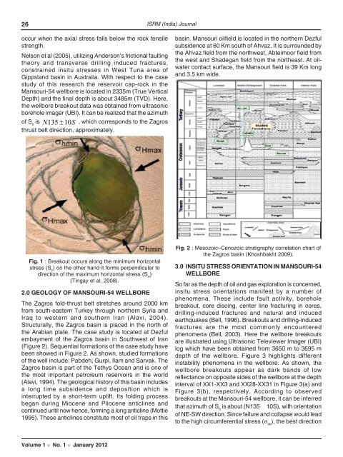
25DETERMINATION OF STRESS ORIENTATION ANDMAGNITUDE IN A DIRECTIONAL WELL BORE, CASESTUDY: MANSOURI-54 WELLBORE OF SOUTHWESTIRANIAN OILFIELDO. Saeidi and M. AhmadiRock Mechanics Department, Tarbiat Modares University, IranAbstract : Knowledge of insitu stress tensor is critical in developing petroleum fields, mineral resourcesand other underground excavations. Since this research is focusing on stress determination in a directionalwellbore, based on available data, the well-54 from the Mansouri field was selected as a case study. Thewellbore is located in the Zagros basin in south-western of the Iran. With ultrasonic borehole image log(UBI), the orientation of the minimum horizontal stress (S h) was determined using borehole breakoutmethod. Then, the magnitude of vertical stress (S v) was calculated by integrating density formation fromsurface to the given depth. In fact, magnitude of S hwas determined by generalizing Breckels and vanEekelen’s expressions (Fjaer, et al. 2008). At any given depth the maximum horizontal stress (S H)constrained by Anderson’s faulting theory and Coulomb faulting theory for an assumed coefficient offriction. In the present study, the stress gradients have indicated that the stress regime corresponds tothe strike slip faulting condition (S x≡S H>S z≡S v>S y≡S h). It was observed that S hdirection corresponds tothe Zagros thrust belt and optimum orientation of drilling the wellbores to minimize wall collapse in thisarea is located on NE-SW direction.Keywords: Insitu stress, Mansouri-54 wellbore, Anderson’s faulting theory, Image log, Zagros thrustbelt.1.0 INTRODUCTIONA practical engineering solution to optimal mud weightdetermination, stable trajectories and casing set pointsproblems requires the accurate knowledge of stress stateat depth (Willson 1999). To determine insitu stresses,Zoback et al. (1993) and Brudy et al (1997) for the firsttime performed a comprehensive project using anintegrated stress measurement strategy (ISMS). In thesame fashion, Reynolds et al. (2006) tried to constrainthe insitu stresses at Cooper- Eromanga basin inAustralia. They concluded that the insitu stress is thedirect outcome of complex interactions between tectonicstresses and convergent plates. In this research, theorientation and magnitude of insitu stress in the Mansouri-54 wellbore is constrained using Anderson’s frictionalfaulting. In the drilling process, usually two types ofcommon wellbore instability occur: wellbore breakout anddrilling induced tensile fractures (DITF). In fact, theborehole breakouts are stress-induced enlargements ofthe wellbore cross-section (Bell 1990).When a wellbore is drilled, materials removed from thesubsurface no longer support the surrounding rock hence,stresses become concentrated in the surrounding rock(i.e., the wellbore wall). In other words, the boreholebreakout occurs once the stresses around the boreholeexceed compressive strength of the rock around theborehole wall (Zoback et al. 1985). The wellbore breakoutis caused by the development of intersecting conjugateshear zones which tend to spalling of the wellbore walls(Figure 1). Around a vertical borehole, the stressconcentration (ratio of rock compressive strength tomaximum principal stress) is greatest and positive in thedirection of S hwhile it has minimum and minus magnitudein S Hdirection. Hence, the long axis of borehole breakoutsare oriented approximately perpendicular to the S Hdirection (Plumb and Hickman 1985).Figure 1 shows creation of borehole breakout along theS hthat indicated as σ hmin. The borehole breakouts areinterpreted typically from acoustic image log data usingthe borehole radius (or travel time) image in combinationwith images of the reflected amplitude. In fact, the drillinginducedfractures can only be observed on image logs.Both natural and drilling-induced fractures are poorreflectors of acoustic energy (Tingay et al. 2008). Usingborehole breakout and Anderson’s theory, Wiprut andZoback (2000) constrained the insitu stresses in Visundfield. They determined the stress region according to thevariation of the rock compressive strength in fivewellbores. In most of the wellbores, there were no tensilefractures. Sometimes transverse drilling induced fracturesVolume 1 v No. 1 v January 2012
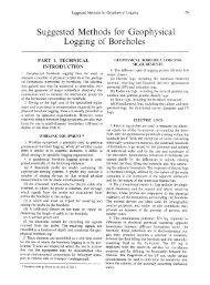
26 <strong>ISRM</strong> (India) Journaloccur when the axial stress falls below the rock tensilestrength.Nelson et al (2005), utilizing Anderson’s frictional faultingtheory and transverse drilling induced fractures,constrained insitu stresses in West Tuna area ofGippsland basin in Australia. With respect to the casestudy of this research the reservoir cap-rock in theMansouri-54 wellbore is located in 2335m (True VerticalDepth) and the final depth is about 3485m (TVD). Here,the wellbore breakout data was obtained from ultrasonicborehole imager (UBI). It can be realized that the azimuthof S his N135 ± 10S, which corresponds to the Zagrosthrust belt direction, approximately.basin. Mansouri oilfield is located in the northern Dezfulsubsidence at 60 Km south of Ahvaz. It is surrounded bythe Ahvaz field from the northwest, Abteimoor field fromthe west and Shadegan field from the northeast. At oilwatercontact surface, the Mansouri field is 39 Km longand 3.5 km wide.Fig. 1 : Breakout occurs along the minimum horizontalstress (S h) on the other hand it forms perpendicular todirection of the maximum horizontal stress (S H)(Tingay et al. 2008).2.0 GEOLOGY OF MANSOURI-54 WELLBOREThe Zagros fold-thrust belt stretches around 2000 kmfrom south-eastern Turkey through northern Syria andIraq to western and southern Iran (Alavi, 2004).Structurally, the Zagros basin is placed in the north ofthe Arabian plate. The case study is located at Dezfulembayment of the Zagros basin in Southwest of Iran(Figure 2). Sequential formations of the case study havebeen showed in Figure 2. As shown, studied formationsof the well include: Pabdeh, Gurpi, Ilam and Sarvak. TheZagros basin is part of the Tethys Ocean and is one ofthe most important petroleum reservoirs in the world(Alavi, 1994). The geological history of this basin includesa long time subsidence and deposition which isinterrupted by a short-term uplift. Its folding processbegan during Miocene and Pliocene anticlines andcontinued until now hence, forming a long anticline (Mottie1995). These anticlines constitute most of oil traps in thisFig. 2 : Mesozoic–Cenozoic stratigraphy correlation chart ofthe Zagros basin (Khoshbakht 2009).3.0 INSITU STRESS ORIENTATION IN MANSOURI-54WELLBORESo far as the depth of oil and gas exploration is concerned,insitu stress orientations manifest by a number ofphenomena. These include fault activity, boreholebreakout, core discing, center line fracturing in cores,drilling-induced fractures and natural and inducedearthquakes (Bell, 1996). Breakouts and drilling-inducedfractures are the most commonly encounteredphenomena (Bell, 2003). Here the wellbore breakoutsare illustrated using Ultrasonic Televiewer Imager (UBI)log which have been obtained from 3650 m to 3695 mdepth of the wellbore. Figure 3 highlights differentinstability phenomena in the wellbore. As shown, thewellbore breakouts appear as dark bands of lowreflectance on opposite sides of the wellbore at the depthinterval of XX1-XX3 and XX28-XX31 in Figure 3(a) andFigure 3(b), respectively. According to observedbreakouts at the Mansouri-54 wellbore, it can be inferredthat azimuth of S his about (N135 10S), with orientationof NE-SW direction. Since failure and collapse would leadto the high circumferential stress (σ θθ), the best directionVolume 1 v No. 1 v January 2012