Wright's Mesa Master Plan - San Miguel County
Wright's Mesa Master Plan - San Miguel County
Wright's Mesa Master Plan - San Miguel County
- No tags were found...

Create successful ePaper yourself
Turn your PDF publications into a flip-book with our unique Google optimized e-Paper software.
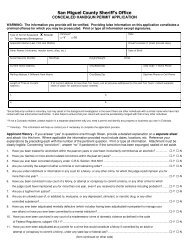
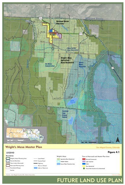
142326132425181930172029tu145A16CR W3521CR Z42hgCR 42Z S2215Norwood <strong>Master</strong><strong>Plan</strong> AreaMaverick Draw2314261324tu145A1918M o n t r o s e C o u n t yS a n M i g u e l C o u n t y<strong>San</strong> <strong>Miguel</strong> River17202116UncompahgreNational Forest152214233521114361121331T 45N6Naturita CreekB.L.M.3257 81817CR Y4349162833CR 41.5Y27hgElk WinterConcentration15NORWOOD34310CR 43Z S352StateLandWater ServiceArea (illustrative)CR 44Z S2536<strong>Wright's</strong> <strong>Mesa</strong>Agriculture /Rural Residential111217CR Y43CR Y4563031SourceWaterProtectionCR 46X829325Beaver Creek2833B.L.M.49102734tu14532635211232419202122NationalForest14231324Gurley Ditch181917201621151426253022233521136112R 14WT 44N31672928UncompahgreNational Forest32335489Thunder Rd.27310Red Cone Dr. CR S4422634 3511GunnisonSageGrouseHabitat25GurleyReservoir12361R 13W30316729325894283310327342635211141318<strong>Wright's</strong>161715Norwood1413<strong>Mesa</strong>1817tu 161462A15tu 145A¯tu 145ATelluride23240 5 10 20 193021202224Miles2319 220 0.375 0.7520 1.5 21 2.25 323<strong>San</strong> <strong>Miguel</strong> <strong>County</strong>Miles26 2530<strong>San</strong> <strong>Miguel</strong> River<strong>Wright's</strong> <strong>Mesa</strong> <strong>Master</strong> <strong>Plan</strong><strong>San</strong> <strong>Miguel</strong> <strong>County</strong>, ColoradoLEGENDFigure 4.1Boundaries<strong>Wright's</strong> <strong>Mesa</strong> <strong>Plan</strong>ning Area<strong>County</strong> BoundaryTown Limits (Norwood)Norwood <strong>Plan</strong>ning AreaTownship & RangeSectionLocal Road<strong>County</strong> RoadHighwayRiver or StreamLake or Reservoir<strong>Wright's</strong> <strong>Mesa</strong>Agriculture/Rural ResidentialWildlife HabitatSource Water Protection AreaTown of Norwood and <strong>Master</strong> <strong>Plan</strong> AreahgNorwood CommercialLight IndustrialPublicTown ResidentialFuture Park (location to be determined)Source: <strong>San</strong> <strong>Miguel</strong> <strong>County</strong> GIS, Clarion Associates February 2008FUTURE LAND USE PLAN