Chapter 4. Future Land Use <strong>Plan</strong><strong>San</strong> <strong>Miguel</strong> <strong>County</strong> Wright’s <strong>Mesa</strong> <strong>Master</strong> <strong>Plan</strong>Recommendations to Improve OLP Site<strong>Plan</strong>ning Process—Site Analysis and <strong>Plan</strong>A thorough site analysis is a key first step fordevelopment of any property. This <strong>Plan</strong>recommends enhancing the process by whichland is subdivided and developed as follows.A. Identify Site Features, Site AnalysisFirst, identify the following:1 Roads, trails, utility easements andrights-of-way,2 Topography (steep slopes andridgelines),3 Environmentally sensitive areas,including but not limited to streams,ditches, source water protection area,drainages, and wetlands.4 Wildlife habitat,5 Geologic hazard areas,6 Adjacent public lands,7 Existing conservation easements orprotected lands,8 Adjacent property lot sizes, setbacks, andbuilding sizes,9 Built features, including driveways, farmroads, buildings, fences, walks, barns orsheds, drainage fields, utilities and utilityeasements, and10 Historically and culturally significant sitesor structures.B. Delineate Conservation Area(s) and ShowBuildable AreaNext, delineate the conservation area(s) to:1 Provide contiguity with adjacent openlands, conservation areas, andagriculture lands.2 Protect unique natural, historic, orcultural site features.3 Provide a minimum buffer of 100 feetbetween any residential structure andadjacent agricultural activities or openlands.4 Provide a minimum buffer for residentiallots of 100 feet along county roads oralong Highway 145.5 Avoid fragmentation of conservationareas within the site.(a) An illustrative 160-acre site…(b) With standard 1 unit per 35 acre subdivision.(c) Site analysis example for the 160 acresdelineating conservation areas.34
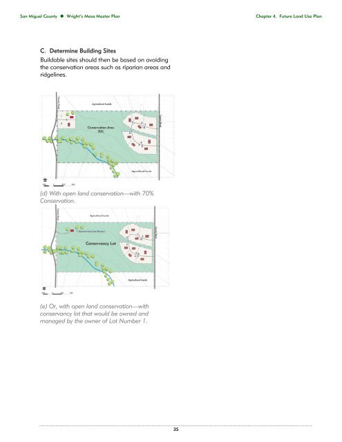
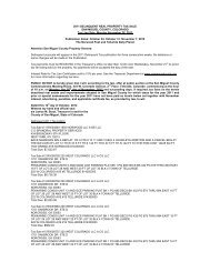
<strong>San</strong> <strong>Miguel</strong> <strong>County</strong> Wright’s <strong>Mesa</strong> <strong>Master</strong> <strong>Plan</strong>Chapter 4. Future Land Use <strong>Plan</strong>C. Determine Building SitesBuildable sites should then be based on avoidingthe conservation areas such as riparian areas andridgelines.(d) With open land conservation—with 70%Conservation.(e) Or, with open land conservation—withconservancy lot that would be owned andmanaged by the owner of Lot Number 1.35