An Atlas of Cerulean Warbler Populations - Cornell Lab of Ornithology
An Atlas of Cerulean Warbler Populations - Cornell Lab of Ornithology
An Atlas of Cerulean Warbler Populations - Cornell Lab of Ornithology

Create successful ePaper yourself
Turn your PDF publications into a flip-book with our unique Google optimized e-Paper software.
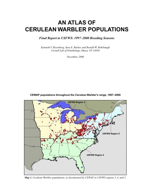
AN ATLAS OFCERULEAN WARBLER POPULATIONSFinal Report to USFWS: 1997–2000 Breeding SeasonsKenneth V. Rosenberg, Sara E. Barker, and Ronald W. Rohrbaugh<strong>Cornell</strong> <strong>Lab</strong> <strong>of</strong> <strong>Ornithology</strong>, Ithaca, NY 14850December, 2000CEWAP populations throughout the <strong>Cerulean</strong> <strong>Warbler</strong>’s range, 1997–2000USFWS Region 3USFWS Region 5USFWS Region 4Map 1. <strong>Cerulean</strong> <strong>Warbler</strong> populations, as documented by CEWAP, in USFWS regions 3, 4, and 5.
INTRODUCTIONThe <strong>Cerulean</strong> <strong>Warbler</strong> <strong>Atlas</strong> Project (CEWAP) was afour-year study designed to determine the populationstatus, habitat, and area requirements <strong>of</strong> <strong>Cerulean</strong><strong>Warbler</strong>s (Dendroica cerulea), a high-priority Neotropicalmigratory bird, within USFWS Regions 3, 4, and5. This study employed volunteer birders as well aspr<strong>of</strong>essional biologists, and was administered throughthe Partners in Flight (PIF) regional and state workinggroups, USFWS contacts, and the <strong>Cornell</strong> <strong>Lab</strong> <strong>of</strong><strong>Ornithology</strong>’s network <strong>of</strong> citizen-scientists. ThisCEWAP Final Report summarizes and reports datasubmitted by each participating state and region fromthe 1997 to 2000 breeding seasons.Need For ProjectThe <strong>Cerulean</strong> <strong>Warbler</strong> is among the highest prioritylandbirds for conservation in the United States. It ranksas extremely high priority on the national Watchlistbased on Partners in Flight prioritization scores, and itranks second in terms <strong>of</strong> immediate conservationconcern in the PIF Northeast region (Rosenberg andWells 1995, 2000). These priority rankings are basedon a small total population size and a significantdeclining Breeding Bird Survey (BBS) trend throughoutits range (-4.2% per year since 1966). <strong>Cerulean</strong> <strong>Warbler</strong>sare declining across much <strong>of</strong> their North Americanbreeding range and are now listed as a species <strong>of</strong> concernin 13 states, threatened in 2 states, and endangered in 1state. They are also federally listed as “vulnerable” inCanada. In portions <strong>of</strong> the Northeast, however, <strong>Cerulean</strong><strong>Warbler</strong>s are thought to be expanding their range andpopulation size. In the Midwest and Southeast—as wellas areas in the Northeast such as New England, NewYork and New Jersey—this species is not adequatelysampled by the BBS because <strong>of</strong> low overall density. Therefore,its distribution in these areas remains poorly knownand accurate population trends have not been estimated.Because <strong>of</strong> severe declines throughout the <strong>Cerulean</strong>’srange, the USFWS has recently completed a Status Assessment<strong>of</strong> <strong>Cerulean</strong> <strong>Warbler</strong>s (Hamel 2000), for possiblelisting under the Endangered Species Act. Hamel(2000) provides a compilation <strong>of</strong> historical records andcontemporary anecdotes about the status <strong>of</strong> this bird;however, the report is limited by the lack <strong>of</strong> recent publishedinformation on this species from most states. Inparticular, conservation planning for regional populationsis hampered by poor knowledge <strong>of</strong> present-daybreeding locations, as well as by a lack <strong>of</strong> local dataregarding habitat affinities, area requirements, or threats.In October 2000, a petition was filed to list the <strong>Cerulean</strong><strong>Warbler</strong> as federally threatened. In light <strong>of</strong> theStatus Assessment and the petition, updated data concerningthe <strong>Cerulean</strong>’s status, population numbers, andcritical breeding sites are <strong>of</strong> utmost importance. CEWAPattempted to fill these knowledge gaps by coordinatingthe efforts <strong>of</strong> pr<strong>of</strong>essional biologists and experiencedbirders through a simple protocol designed to surveyand study <strong>Cerulean</strong> <strong>Warbler</strong>s throughout each region.Project GoalsThe original goals <strong>of</strong> CEWAP, as stated in the Scope<strong>of</strong> Work to the USFWS, were as follows:• Identify important populations <strong>of</strong> <strong>Cerulean</strong> <strong>Warbler</strong>sin each state, and determine the status <strong>of</strong> these populations—howmany pairs? Are they reproducing successfully?Are there local threats to the population?Are populations expanding or declining?• Determine the range <strong>of</strong> acceptable habitats and arearequirements in each region—measure habitat structure,landscape characteristics <strong>of</strong> sites, nest-site characteristics,estimate densities in different forest-types,attempt to estimate productivity.• Identify suites <strong>of</strong> bird and plant species associatedwith <strong>Cerulean</strong> <strong>Warbler</strong>s• Set population and habitat goals for the Northeastregion and sub-region units, as part <strong>of</strong> the regionalPIF planning process• Produce a “how-to” manual <strong>of</strong> habitat managementstrategies for areas having (or potentially supporting)<strong>Cerulean</strong> <strong>Warbler</strong>sThis atlas <strong>of</strong> <strong>Cerulean</strong> <strong>Warbler</strong> populations addressesthe first portion <strong>of</strong> these ambitious goals. In this reportwe identify specific locations <strong>of</strong> present-day breedingpopulations in each region and state and attempt to estimatepopulation sizes based on data collected by over200 field collaborators. We also provide summaries <strong>of</strong>the habitat types and dominant tree species present atsites occupied by breeding <strong>Cerulean</strong> <strong>Warbler</strong>s. Additionalanalyses <strong>of</strong> CEWAP data using GIS may elucidatepatterns <strong>of</strong> habitat use at the landscape and regionalscales. The results <strong>of</strong> this atlas will be incorporated intoPIF landbird conservation plans; in particular, lists <strong>of</strong>specific sites for management or acquisition, as well aslocal data on habitats used, will aid in setting regionalpopulation objectives for this species. Our intention isto publish a completed version <strong>of</strong> this atlas, along withthe most up-to-date summary <strong>of</strong> conservation andmanagement guidelines, based on CEWAP and otherinformation.3
METHODSCEWAP took advantage <strong>of</strong> the expertise <strong>of</strong> activebirders and pr<strong>of</strong>essional biologists by employing networks<strong>of</strong> volunteers. The <strong>Lab</strong> <strong>of</strong> <strong>Ornithology</strong> hired fieldassistants in 1997, 1998, and 1999 to cover areas thoughtto be potentially important breeding areas for ceruleans.These specific areas within states were systematicallysearched; however, coverage <strong>of</strong> entire states was <strong>of</strong>tenstill incomplete.Field protocols consisted primarily <strong>of</strong> surveyingknown sites (determined through state atlas workers,other birders, and published literature) to determinenumbers <strong>of</strong> pairs, breeding status <strong>of</strong> population, andconservation status <strong>of</strong> site. In addition, participants surveyedas many new or potential sites as possible, to identifynew breeding sites and determine status (as in thefirst project goal). At a small subset <strong>of</strong> sites with largeor important populations, additional data on nesting andforaging, as well as productivity and threats to populations,was available through collaborating researchers.Because <strong>of</strong> our reliance on volunteers and unsupervisedfield assistants, and the large differences in terrainand habitats surveyed, there was much variation inactual survey methods employed in the field. A majority<strong>of</strong> data came from variations on the “area-search”method, where observers moved through potential habitatsnoting presence and numbers <strong>of</strong> singing male <strong>Cerulean</strong><strong>Warbler</strong>s. Variations ranged from systematic surveysalong all navigable waterways by canoe in theMontezuma Wetlands Complex <strong>of</strong> NY (Bill Evans), todriving slowly along rural roads in northern NJ (JohnBenzinger), to hiking the Appalachian Trail in Virginia andNorth Carolina, to floating stretches <strong>of</strong> several rivers inMissouri, to systematically driving and hiking throughforested regions and conducting point counts whereverceruleans were detected (David Buehler), to spot-checkingisolated woodlots. Field surveys <strong>of</strong>ten used recorded<strong>Cerulean</strong> <strong>Warbler</strong> vocalizations (as needed) to elicit responsesfrom territorial males, approximate territorialboundaries (especially in linear habitats), and determinepairing status (females <strong>of</strong>ten respond to tapes within theirterritories). After visits to a site were completed, observerswere asked to attempt an estimate <strong>of</strong> the totalbreeding population <strong>of</strong> <strong>Cerulean</strong> <strong>Warbler</strong>s at that site.In addition to these CEWAP surveys, we receivedseveral datasets with point-count locations for <strong>Cerulean</strong><strong>Warbler</strong>s, <strong>of</strong>ten detected during more general bird surveys.In these cases, it is <strong>of</strong>ten impossible to know howmuch available habitat was covered or what proportion<strong>of</strong> a regional population <strong>of</strong> <strong>Cerulean</strong> <strong>Warbler</strong>s wassampled—these are retained in our <strong>Atlas</strong> as minimumestimates for these areas. In a few states we relied onadditional surveys conducted prior to CEWAP or as part<strong>of</strong> independent research efforts. Finally, some holes inour <strong>Atlas</strong> were filled by gleaning miscellaneous recordsfrom birding e-mail lists, recently published BreedingBird <strong>Atlas</strong>es, or by hounding certain birders and statebiologists until they told us what they knew.We instructed participants to define a “site” as anycontiguous patch <strong>of</strong> similar and suitable habitat surroundedby a different habitat type. Because <strong>of</strong> the greatvariation in survey methods and types <strong>of</strong> data we received,the actual designation <strong>of</strong> sites in our database ishighly inconsistent. These range from specific locations<strong>of</strong> individual <strong>Cerulean</strong> <strong>Warbler</strong>s within a larger contiguousarea, to politically defined State Park or WildlifeManagement Area boundaries, to entire river valleyswith their adjacent slopes. In all cases; however, a “site”represents a unique latitude and longitude provided bya participant and entered into our database. Althoughthis variation leads to difficulties in interpreting numbersor proportions <strong>of</strong> sites occupied in various regionsor states, this flexibility in our protocols enabled us toreceive the maximum amount <strong>of</strong> data from the widestgroup <strong>of</strong> volunteers and collaborators.All sites were located on topographic maps, and dataon habitat, landscape characteristics, and land ownershipwere noted on simple data forms. Specifically, fieldobservers recorded site location, latitude and longitude,elevation, history <strong>of</strong> disturbance, general habitat type(riparian, swamp forest, dry slope, etc.), three or moredominant tree species, and canopy height. This informationwas compiled and entered into a GIS databaseby <strong>Lab</strong> <strong>of</strong> <strong>Ornithology</strong> biologists.4
Range-wide SummaryA total <strong>of</strong> 280 CEWAP participants and collaboratorsreported data on <strong>Cerulean</strong> <strong>Warbler</strong>s; these included29 paid field assistants hired over the 3-year period(Table 1; see also Appendix 1 for complete list <strong>of</strong>CEWAP participants). The sum <strong>of</strong> data we received accountedfor 7,669 <strong>Cerulean</strong> <strong>Warbler</strong>s at 1,923 sites in28 states, plus Ontario. Virtually all reports were <strong>of</strong> singingmales; therefore numbers reported throughout thisRESULTS<strong>Atlas</strong> are assumed to represent number <strong>of</strong> territorialmales or breeding pairs. <strong>An</strong> additional 355 sites weresearched with no birds found; in general observers onlyreported positive sightings, and these do not representrandom samples <strong>of</strong> available areas or habitats. Note too,that “sites” ranged in scope from individual point-locationsto whole river valleys, so these data provide onlya rough indication <strong>of</strong> number <strong>of</strong> different areas that support<strong>Cerulean</strong> <strong>Warbler</strong> populations.Table 1. Summary <strong>of</strong> CEWAP participants, numbers <strong>of</strong> sites, and number <strong>of</strong> <strong>Cerulean</strong> <strong>Warbler</strong>s reported, by state,1997–1999.State Number Number Number Number Number<strong>of</strong> participants returning <strong>of</strong> sites <strong>of</strong> sites <strong>of</strong> birdssigned up data surveyed with birds foundAlabama 7 1 6 6 7Arkansas 12 4 48 46 145Connecticut 22 7 20 13 34District <strong>of</strong> Columbia 4 0 - - -Delaware 6 2 7 7 10Georgia 18 5 16 14 22Iowa 9 2 9 9 22Illinois 26 3 32 21 1000+Indiana 22 8 73 34 342Kansas 1 1 1 1 1Kentucky 17 8 113 59 140Massachusetts 22 6 11 10 18Maryland 17 6 11 9 16Maine 4 0 - - -Michigan 36 15 183 176 507Minnesota 17 4 57 57 103Missouri 14 5 32 31 301Mississippi 2 0 - - -Nebraska 2 1 1 1 1New Hampshire 5 0 - - -New Jersey 18 7 32 31 157New York 159 57 286 246 1068North Carolina 19 12 42 39 109Ohio 46 17 78 62 264Oklahoma 2 0 - - -Ontario 9 1 5 4 228Pennsylvania 81 38 206 182 548Rhode Island 3 1 1 0 0South Carolina 3 0 - - -South Dakota 2 2 2 2 3Tennessee 27 14 488 485 1210Virginia 48 15 106 64 152Vermont 13 2 4 3 3Wisconsin 25 10 60 59 174West Virginia 68 27 345 254 1124TOTALS 786 280 2274 1923 76695
The scope and distribution <strong>of</strong> rangewide surveys isillustrated in Map 1 (frontispiece). <strong>Populations</strong> weresurveyed throughout the entire range <strong>of</strong> the species, althoughcoverage in many areas was patchy or incomplete.The largest number <strong>of</strong> birds were found in Tennessee,West Virginia, New York, and Illinois (Table 1;see state summaries below). These numbers require additionalinterpretation; however, because relative coverage<strong>of</strong> available sites varied greatly among states. Forexample, coverage was fairly complete near the periphery<strong>of</strong> the species’ range (counts in NY and IL thereforemay be close to total state populations), whereas only asample <strong>of</strong> areas was covered in states near the center <strong>of</strong>the range (WV, TN, PA, KY).The largest gaps in our overall atlas coverage werein Kentucky (entire state), western Maryland and Virginia,southern Ohio, and the Missouri Ozarks. In addition,many areas <strong>of</strong> West Virginia, Pennsylvania, Arkansas,and southern Indiana were only partially surveyed.Although population estimates may not be representativefor many states, CEWAP identified a large number<strong>of</strong> specific areas that are currently known to supportsignificant populations <strong>of</strong> <strong>Cerulean</strong> <strong>Warbler</strong>s. For example,nearly 60% <strong>of</strong> all birds found were concentratedin 37 geographic areas in 16 states and Ontario (Table2). Areas with the largest concentrations included theCumberland Mountains northwest <strong>of</strong> Knoxville, Tennessee,the Montezuma Wetlands Complex and adjacentareas in central New York, Kaskaskia River Valleyand Shawnee National Forest in southeastern Illinois,Jefferson Proving Ground <strong>of</strong> southern Indiana, QueensUniversity Biological Station in southeastern Ontario,Kalamazoo River <strong>of</strong> southwestern Michigan, the ElevenPoint and Upper Current Rivers in Missouri,Shenendoah National Park and Blue Ridge Highway inwestern Virginia, and the Delaware River Valley andadjacent highlands <strong>of</strong> northwestern New Jersey. The totalpopulation in West Virginia, Kentucky, and westernPennsylvania is certainly much higher than these numbers,but <strong>Cerulean</strong> <strong>Warbler</strong>s are less concentrated inspecific areas (i.e. the habitat is more continuous).<strong>An</strong> additional 36 areas supported from 20-50 singingmale <strong>Cerulean</strong>s and accounted for another 978 (13%)<strong>of</strong> the total birds detected (Table 3). These may representsecondary areas for long-term monitoring <strong>of</strong> <strong>Cerulean</strong><strong>Warbler</strong> populations.6
Table 2. Areas supporting the largest <strong>Cerulean</strong> <strong>Warbler</strong> populations (≥ 50 pairs), rangewide. These locations mayrepresent primary areas for future population monitoring. See state summaries for more specific locations andinformation on these areas.# Birds State Area Habitat Type430 TN Royal Blue Wildlife Management Area, Mesic slopes, cove forestCumberland Plateau325 NY Montezuma Wetlands Complex Riparian, forested wetland300+ IL Kaskaskia River Mixed floodplain238 TN Center Hill Lake Area, Edgar Evins State Park Mesic slope, dry slope202 IN Jefferson Proving Ground Mesic upland forest200 ON Bedford/Queen’s University Biological Station Upland, bottomland200+ IL Illinois Ozarks, Shawnee National Forest White-oak dominated forest slopes177 MI Kalamazoo River, Alleghan State Game Area Riparian, swamp forest167 NY Alleghany State Park and vicinity Riparian, dry slopes150+ IL Cave/Cedar Creek Sycamore-boxelder142 TN Frozen Head State Park Mesic slopes138 NY Iroquois NWR, Oak Orchard WMA, Riparian, forested wetlandTonowanda Indian Reservation137 MO Eleven Point River Riparian121 AR Ozark National Forest Upland, bottomland114 MO Upper Current River Riparian108 VA Blue Ridge Parkway, Shenendoah National Park Dry slope, mesic cove forest100+ IL Pere Marquette State Park, Big Rivers White oak-pecan-black locust100 MI Fort Custer and vicinity Dry upland forest95 NY Galen Wildlife Management Area Riparian, forested wetland94 WV New River Gorge—Garden Ground Mountain Area Dry slopes, riparian90 NJ, PA Delaware River Valley Riparian, adjacent slopes78 WV Kanawha State Forest Mesic cove forest, dry slope,riparian78 WV Guyandotte Mountain and vicinity Upland forest75+ KY Daniel Boone National Forest Upland forests75 TN Chickasaw National Wildlife Refuge Riparian swamp forest71 WI Lower Wisconsin River drainages Riparian, adjacent slopes69 PA Jennings Environmental Center, Moraine State Park Dry slope, lake margin65 WV Louis Wetzel WMA Dry slope, riparian63 NY Salmon Creek Riparian, mesic slope60 NC Blue Ridge Parkway, Pisgah National Forest Dry slope, cove forest56 OH Shawnee State Park and Forest Dry slope, riparian54 TN Meeman Shelby State Park, Mississippi Delta region Mesic slope, riparian50+ IL Mississippi Palisades State Park and vicinity White oak-walnut-black locustforest50+ IL Rock River Riparian forest50 NJ Kittatinny Mountains Mesic and dry slopes50 WV Beech Fork State Park Lake margin, dry slope50 WV North Bend State Park and Rail Trai, Dry slope, cove forest, riparianMountwood Park7
Table 3. Areas supporting moderate-sized (20–50 singing males) <strong>Cerulean</strong> <strong>Warbler</strong> populations rangewide. Theselocations may represent secondary areas for long-term monitoring.# Birds State Area Habitat Type45 OH Lake Metroparks Riparian, dry slope44 MI Waterloo Recreation Area Dry upland forest42 PA Juniata River and vicinity Riparian40 WV Greenbrier River drainage and adjacent mountains Dry slopes36 WV Fork Creek WMA—Little Coal River and vicinity Riparian, mesic slope34 OH Zaleski State Forest/ Lake Hope State Park Mesic slope, dry slope34 MO Curtois Creek Riparian33 NY Bear Mountain State Park Dry slope, bottomland32 OH Waterloo Township—Hewett Fork Dry slope, mesic slope32 TN Cheatham Wildlife Management Area Dry slope, mesic slope31 WI Lower Wisconsin River Riparian, mesic slope29 OH Cuyahoga Valley National Recreation Area, Riparian, dry slopeBrecksville Reservation—Cleveland Metroparks29 PA Peter’s Mountain and State Game Lands Dry slope, lake margin28 TN Natchez Trace Parkway, National Park Dry slope, mesic slope28 WV Murphy Preserve Moist cove forest, dry slope, riparian26 NY Castleton Island State Park Riparian, river island25 NJ Hamburg Mountain and vicinity Dry slope, lake margin25 TN Mill Creek Rd. Dry slope24 MI White River Riparian24 WI Wyalusing State Park Dry slope, mesic slope23 PA Brady’s Run County Park Dry slope23 WV Coopers Rock State Forest Mesic slope, dry ridgetop22 MI Brown County State Park Upland, lake margin, riparian22 PA Forbe’s State Forest and vicinity Dry slope22 VA Canoe Lake—Hahn Property Upland22 WV Ritchie Mines WMA Dry slope21 MI St. Joseph River Riparian20 IL Illinois River Valley Cottonwood-oak floodplain forest20 IL Cache River Mixed floodplain forest20 MN Murphy-Hanrehan Park Reserve and County Park Riparian, mesic slope20 NY Letchworth State Park Riparian20 NY West Point Military Reservation ??20 PA Duff Park and Boyce Park Dry slope, riparian20 PA Ten Mile Creek and vicinity Riparian, dry slope20 VA Clinch Ranger District, Jefferson National Forest Dry slope, cove forest20 WI Lake LaGrange Mesic slope8
USFWS Region 3Within USFWS Region 3, CEWAP participants founda total <strong>of</strong> 1,745 <strong>Cerulean</strong> <strong>Warbler</strong>s at roughly 439 sites.This does not include data from Illinois, provided byScott Robinson, which accounted for an additional1,000–3,000 birds in that state. CEWAP coverage waspatchy throughout the region, with the most concentratedefforts in southern Michigan, southeastern Missouri, andsouthern Indiana. A scattering <strong>of</strong> <strong>Cerulean</strong> populationswere located along the Mississippi River and its majortributaries in the upper Midwest, and in the Ohio Riverdrainage along the southern boundary <strong>of</strong> the region. Thelargest single populations in the region are believed tobe located in Illinois along the Kaskaskia River and IllinoisOzarks region (500+ pairs), Jefferson ProvingGround in southern Indiana (200+ pairs), KalamazooRiver and Fort Custer areas in Michigan (275+ pairs),and along the Eleven Point and Upper Current Riversin Missouri (250 pairs). Coverage was poorest in southernOhio and elsewhere in Indiana and Missouri, whereundoubtedly many otherpopulations exist (Map 2.)Overall, <strong>Cerulean</strong> <strong>Warbler</strong>sshowed a distinctly bimodalhabitat distribution, withroughly the same numbers <strong>of</strong>birds found occupying bottomlandand upland habitats.Among the 426 specific siteswith habitat data, roughly40% were in riparian bottomlandforest, accounting for485 <strong>of</strong> the <strong>Cerulean</strong>s found(not counting Illinois). <strong>An</strong> additional305 <strong>of</strong> sites were indry upland forest and 225were in mesic uplands, accountingfor 21% and 28% <strong>of</strong>the birds found, respectively(Figure 1).For 164 sites in Region 3,participants provided data onthe extent <strong>of</strong> available habitatat sites where <strong>Cerulean</strong> <strong>Warbler</strong>soccurred. Although aquantitative analysis <strong>of</strong> forestpatch size is not possible withthese data, we believe thatthey provide a reasonablesample <strong>of</strong> the range <strong>of</strong> tractsizes used in the region.Regional SummariesRegion 3—Habitats (N=426)RiparianbottomlandforestDryuplandforestMesicuplandforestFigure 1. Habitat classifications at sites with <strong>Cerulean</strong><strong>Warbler</strong>s in USFWS Region 3. Numbers <strong>of</strong> individual<strong>Cerulean</strong> <strong>Warbler</strong>s recorded in each habitat type arenoted above the bars. “N” equals number <strong>of</strong> occupiedsites with habitat data reported by CEWAP participants.CEWAP populations in USFWS Region 3, 1997–2000Swampforest/Lake marginRoughly 41% <strong>of</strong> occupied Map 2. <strong>Cerulean</strong> <strong>Warbler</strong> populations and land cover types for USFWS Region 3.Number <strong>of</strong> sitesCEWAP sites with <strong>Cerulean</strong> <strong>Warbler</strong>sdeciduous forestevergreen and mixed foresturban/developementnon-forest habitat9
Number <strong>of</strong> occupied sitesRegion 3—Tract size 5,000 acFigure 2. Numbers <strong>of</strong> occupied sites and forest tractsizes for sites in USFWS Region 3. Numbers <strong>of</strong> individual<strong>Cerulean</strong> <strong>Warbler</strong>s recorded in each tract-size classare noted above the bars.central Tennessee. Small populations were documentedat the edge <strong>of</strong> the species’ range in northern Georgia,northern Alabama, and the coastal plain <strong>of</strong> North Carolina(Roanoke River). No recent breeding records couldbe obtained in Mississippi, South Carolina, or Louisiana.Of 550 specific sites reporting habitat data, the majority(73%) were in mesic upland and moist cove foresthabitats, accounting for 575 <strong>of</strong> the birds foundthroughout the region (Figure 3). <strong>An</strong> additional 265 birdswere found at 70 dry slope and ridgetop sites, whereasonly 13% <strong>of</strong> birds were in riparian forest habitat.For 117 sites in Region 4, participants provided dataon the extent <strong>of</strong> available habitat at sites where <strong>Cerulean</strong><strong>Warbler</strong>s occurred. Although a quantitative analysis<strong>of</strong> forest patch size is not possible with these data,we believe that they provide a reasonable sample <strong>of</strong> therange <strong>of</strong> tract sizes used in the region. Roughly 74% <strong>of</strong>occupied sites were described as 1,000 acres or greaterin extent, accounting for nearly 95% <strong>of</strong> all birds found(Figure 4). Only 4% <strong>of</strong> the birds found in this regionwere in habitat patches ≤ 200 acres.sites were described as 1,000acres or greater, accountingfor 65% <strong>of</strong> all birds found(Figure 2). <strong>An</strong> additional 265birds were found in 70 tractsbetween 200 and 1,000 acres,and fewer than 10% <strong>of</strong> the birdswere in patches ≤ 100 acres.USFWS Region 4In the Southeast region,CEWAP participants and collaboratorsfound a total <strong>of</strong>1,560 <strong>Cerulean</strong> <strong>Warbler</strong>s at633 specific sites (Map 3).Coverage was patchythroughout the region, rangingfrom intensive surveys <strong>of</strong>several key areas in Tennesseeto scattered observationsfrom many other areas. Thebiggest holes in atlas coveragewere in eastern Kentucky. Thelargest <strong>Cerulean</strong> population inthe region is undoubtedly inthe Cumberland Mountainsand Plateau areas <strong>of</strong> Tennesseeand probably Kentucky.Additional significant populationswere located in the BlueRidge <strong>of</strong> North Carolina, theOzarks <strong>of</strong> Arkansas, and inCEWAP populations in USFWS Region 4, 1997–2000CEWAP sites with <strong>Cerulean</strong> <strong>Warbler</strong>sdeciduous forestevergreen and mixed foresturban/developementnon-forest habitatMap 3. <strong>Cerulean</strong> <strong>Warbler</strong> populations and land cover types for USFWS Region 4.10
Region 4—Habitats (N=550)Region 4—Tract sizeNumber <strong>of</strong> occupied sitesNumber <strong>of</strong> occupied sitesMesic cove/slope forestDryslope andridgetopRiparian Swampbottomland forest andforest Lake marginFigure 3. Habitat classifications at sites with <strong>Cerulean</strong><strong>Warbler</strong>s in USFWS Region 4. Numbers <strong>of</strong> individual<strong>Cerulean</strong> <strong>Warbler</strong>s recorded in each habitat type arenoted above the bars. “N” equals number <strong>of</strong> occupiedsites with habitat data reported by CEWAP participants. 5,000 acFigure 4. Numbers <strong>of</strong> occupied sites and forest tractsizes for sites in USFWS Region 4. Numbers <strong>of</strong> individual<strong>Cerulean</strong> <strong>Warbler</strong>s recorded in each tract-size classare noted above the bars.USFWS Region 5In the Northeast Region, atotal <strong>of</strong> 3,077 <strong>Cerulean</strong> <strong>Warbler</strong>swere located at 820 specificsites (Map 4). Intensivesurveys at many sites in WestVirginia and western Pennsylvaniaturned up roughly 1,400<strong>Cerulean</strong>s in the heart <strong>of</strong> thespecies’ range—this is undoubtedlyonly a small fraction<strong>of</strong> the true population inthese states. Outside <strong>of</strong> theOhio Hills physiographicarea, large and significantpopulations were documentedin several areas including theMontezuma Wetlands complexand surrounding areas incentral New York (400+pairs), Allegheny State Parkand National Forest area <strong>of</strong>western New York and Pennsylvania(175+ pairs), theDelaware Water Gap region <strong>of</strong>northwestern New Jersey andadjacent Pennsylvania (150+pairs), and the Blue RidgeParkway area <strong>of</strong> western Virginia(100+ pairs). In addition,smaller populations exist inCEWAP populations in USFWS Region 5, 1997–2000CEWAP sites with <strong>Cerulean</strong> <strong>Warbler</strong>sdeciduous forestevergreen and mixed foresturban/developementnon-forest habitatMap 4. <strong>Cerulean</strong> <strong>Warbler</strong> populations and land cover types for USFWS Region 5.11
Number <strong>of</strong> occupied sitesNumber <strong>of</strong> occupied sitesRiparianbottomland forestRegion 5—Habitats (N=800)Dry slope and ridgeMesic slope/ cove forestOther “Upland”Swamp forestRegion 5—Tract sizeLake marginFigure 5. Habitat classifications at sites with <strong>Cerulean</strong><strong>Warbler</strong>s in USFWS Region 4. Numbers <strong>of</strong> individual<strong>Cerulean</strong> <strong>Warbler</strong>s recorded in each habitat type arenoted above the bars. “N” equals number <strong>of</strong> occupiedsites with habitat data reported by CEWAP participants.the Hudson River Valley and Highlands <strong>of</strong> southeasternNew York, and in many parts <strong>of</strong> Pennsylvania. Smallbut persistent populations were found throughout southernNew England, in northern New York, and in the Piedmont<strong>of</strong> Maryland and Virginia. Finally, although not inthis USFWS Region, a large population <strong>of</strong> <strong>Cerulean</strong><strong>Warbler</strong>s exists in Ontario, not far from the New Yorkborder.As in other regions, <strong>Cerulean</strong> <strong>Warbler</strong>s exhibit a distinctlybimodal habitat distribution in the Northeast. Ofthe 800 specific sites with habitat data, 43% were inriparian or other bottomland forest habitats, accountingfor 44% <strong>of</strong> individual <strong>Cerulean</strong>s found (Figure 5). <strong>An</strong>additional 39% <strong>of</strong> birds were found at 256 dry slope orridgetop sites, with the remainder <strong>of</strong> birds in other uplandhabitats.For 333 sites in Region 5, participants provided dataon the extent <strong>of</strong> available habitat at sites where <strong>Cerulean</strong><strong>Warbler</strong>s occurred. Although a quantitative analysis<strong>of</strong> forest patch size is not possible with these data,we believe that they provide a reasonable sample <strong>of</strong> therange <strong>of</strong> tract sizes used in the region. Roughly 19% <strong>of</strong>occupied sites were described as 1,000 acres or greaterin extent, accounting for 40% <strong>of</strong> all birds found (Figure6). This is a much lower proportion than in the othertwo regions. In contrast, 57% <strong>of</strong> occupied sites weredescribed as ≤ 100 acres, supporting 29% <strong>of</strong> the<strong>Cerulean</strong>s found in this region. Whether these data indicatea lower threshold <strong>of</strong> area sensitivity by <strong>Cerulean</strong><strong>Warbler</strong>s in the Northeast, compared with other regions,or whether the range <strong>of</strong> available habitats searched wasdifferent, is unclear. 5,000 acFigure 6. Numbers <strong>of</strong> occupied sites and forest tractsizes for sites in USFWS Region 5. Numbers <strong>of</strong> individual<strong>Cerulean</strong> <strong>Warbler</strong>s recorded in each tract-size classare noted above the bars.12
State SummariesAlabamaOur current data for Alabama (Map 5) comes fromEric Soehren (e-mail communication, Oct. 2000), whoreported birds from two sites in the Bankhead NationalForest (Lawrence and Winston counties). Five birds wereobserved in the Sipsey Wilderness and 2 were notedalong Flannagin Creek. The total population for this areais thought to possibly be much larger, and more systematicsurveys are recommended.CEWAP <strong>Populations</strong> in Alabama, 1997–2000Map 5. <strong>Cerulean</strong> <strong>Warbler</strong> populations in Alabama. Polygons represent clusters <strong>of</strong>sites where ceruleans were found in close geographic proximity.ArkansasThere is little published information on the presence/absence or relative abundance <strong>of</strong> <strong>Cerulean</strong> <strong>Warbler</strong>s inArkansas; however, Hamel (2000) does cite a few referencessuggesting that the species is common in theOuachita National Forest and western Ozarks. The primaryarea searched by CEWAP participants was theOzark National Forest in the northwestern part <strong>of</strong> thestate (Map 6). It is likely that additional populations existin the Ouachita National Forest and unsearched areas<strong>of</strong> the Mississippi Delta region.CEWAP participants observed 145 birds at 46 (96%)<strong>of</strong> 48 sites visited in Arkansas. Of these, 121 (83%)were noted in the Ozark National Forest and 14 (10%)were detected in Desha and Prairie counties <strong>of</strong> the MississippiDelta region (Table 4). No birds were discoveredat two separate sites along the Ouachita River (nearCallion) and the Saline River (near Rison). Data fromthe Ozark National Forest consisted <strong>of</strong> individual <strong>Cerulean</strong><strong>Warbler</strong>s reported on point counts; it is unclear how completethis sampling was for the species in this region.Table 4. Important areas for breeding <strong>Cerulean</strong> <strong>Warbler</strong>s in Arkansas.Number<strong>of</strong> birds Site location County (s) Habitat (s) Elevation (ft)121 Ozark National Forest 6 counties Upland, bottomland 750–225014 Mississippi Delta region Desha, Prairie Bottomland 145–18313
CEWAP <strong>Populations</strong> in Arkansas, 1997–2000Sites with 5 or fewer <strong>Cerulean</strong> <strong>Warbler</strong>sMap 6. <strong>Cerulean</strong> <strong>Warbler</strong> populations in Arkansas. Polygons represent clusters <strong>of</strong>sites where ceruleans were found in close geographic proximity. These do not necessarilymatch specific areas listed in the corresponding state table.Of the 46 sites with <strong>Cerulean</strong>s, 35 (76%) were classifiedas upland and 12 (25%) were bottomland (Figure7). Upland sites accounted for 113 (79%) <strong>Cerulean</strong> observations,whereas 30 (21%) birds were observed inbottomland habitats.Among the 33 sites that recorded tree species, uplandsites were dominated by oaks (mostly red oak) andhickories, whereas bottomland sites reported sweetgum,maples, and sycamore (Figure 8).AR Habitats (N=47)AR Tree Species (N=33)Number <strong>of</strong> occupied sitesNumber <strong>of</strong> occupied sitesUplandBottomlandFigure 7. Habitat classifications at sites with <strong>Cerulean</strong><strong>Warbler</strong>s in Arkansas. Numbers <strong>of</strong> individual <strong>Cerulean</strong><strong>Warbler</strong>s recorded in each habitat type are noted abovethe bars. “N” equals number <strong>of</strong> occupied sites withhabitat data reported by CEWAP participants.Oaks Hickories Maples SweetgumFigure 8. Predominant tree species reported at occupiedsites in Arkansas. “N” equals number <strong>of</strong> sites withtree species reported by CEWAP participants.14
ConnecticutThe <strong>Atlas</strong> <strong>of</strong> Breeding Birds in Connecticut reported<strong>Cerulean</strong> <strong>Warbler</strong>s from 6.5% <strong>of</strong> all atlas blocks (Bevier1994). CEWAP coverage in Connecticut was patchy, butdistributed in several regions. <strong>Cerulean</strong>s were observedin all regions searched, except the extreme southwestcorner near the towns <strong>of</strong> Redding and Weston (Map 7).CEWAP participants counted 34 birds at 13 (65%)<strong>of</strong> 20 sites visited in Connecticut. Of the 34 individuals,10 (29%) were noted in Natchaug State Forest inWindham County. Other important areas for <strong>Cerulean</strong>sincluded habitat along the Housatonic River in LitchfieldCounty and the Session Woods Wildlife ManagementArea in Hartford County (Table 5). Additional singlebirds were found at Kahn Preserve near New Milford,Nehantic State Forest near Lyme, Bend <strong>of</strong> the RiverAudubon Center near Southbury, and the Yale Forest inWindham County. Among the areas searched that didnot have <strong>Cerulean</strong>s were Devil’s Den Preserve andLimekiln Natural area in Fairfield County.Riparian and other bottomland sites accounted for16 <strong>of</strong> the 34 cerulean observations, whereas 12 <strong>Cerulean</strong>swere noted in upland forest habitats (Figure 9).Oaks and maples were the most commonly reportedtree species at occupied sites; however, birch, hickory,sycamore, and eastern hemlock were also reported (Figure10). The Natchaug State forest is a 12,500 acre sitedominated by red oak, white oak, black oak and hickory,whereas sites along the Housatonic River had sycamores,red and silver maples, white oaks, and ash.CEWAP <strong>Populations</strong> in Connecticut, 1997–2000Sites with 5 or fewer <strong>Cerulean</strong> <strong>Warbler</strong>sMap 7. <strong>Cerulean</strong> <strong>Warbler</strong> populations in Connecticut. Polygons represent clusters<strong>of</strong> sites where ceruleans were found in close geographic proximity. These do notnecessarily match specific areas listed in the corresponding state table.Table 5. Important areas for breeding <strong>Cerulean</strong> <strong>Warbler</strong>s in Connecticut.Number<strong>of</strong> birds Site location County (s) Habitat (s) Elevation (ft)10 Natchaug State Forest Windham Lake margin, dry slope ??6 Housatonic River—Kent, Bull’s Bridge Litchfield Riparian 3705 Session Woods WMA Hartford Riparian 7503 Pleasant Valley Nature Preserve Middlesex ?? ??3 Hartman Park, Lyme Middlesex ?? ??2 Still River Preserve Litchfield Riparian 25015
CT Habitats (N=14)CT Tree Species (N=14)Number <strong>of</strong> occupied sitesNumber <strong>of</strong> occupied sitesRiparianUplandSwamp forestFigure 9. Habitat classifications at sites with <strong>Cerulean</strong><strong>Warbler</strong>s in Connecticut. Numbers <strong>of</strong> individual <strong>Cerulean</strong><strong>Warbler</strong>s recorded in each habitat type are notedabove the bars. “N” equals number <strong>of</strong> occupied siteswith habitat data reported by CEWAP participants.OaksMaplesBirchHickorySycamoreHemlockFigure 10. Predominant tree species reported at occupiedsites in Connecticut. “N” equals number <strong>of</strong> siteswith tree species reported by CEWAP participants.DelawareHamel (2000) reported that “Preliminary results fromthe Delaware Breeding Bird <strong>Atlas</strong> indicate the birds werefound in two blocks in the northern part <strong>of</strong> the state (LisaGelvin-Innavaer, pers. comm., 18 Sept. 1996).”CEWAP participants counted 10 <strong>Cerulean</strong> <strong>Warbler</strong>sat 7 sites in the northern Delaware county <strong>of</strong> New Castle(Map 8). All these birds were along White Clay Creekin riparian and adjacent upland forest. The forest wasdominated by sycamore, maples, tulip tree, and walnut.This area is adjacent to a site with two additional birdsat the White Clay Creek Preserve in Chester County,PA.CEWAP <strong>Populations</strong> in Delaware, 1997–2000Map 8. <strong>Cerulean</strong> <strong>Warbler</strong> populations in Delaware. Polygons represent clusters <strong>of</strong>sites where ceruleans were found in close geographic proximity.16
GeorgiaCEWAP surveys yielded 22 birds at 14 (87%) <strong>of</strong> 16sites visited (Map 9). Nearly all the birds were on theChattahoochee National Forest in Union County, be-tween 2,640 and 3,400 ft. elevation, either on dry slopesor in cove forest. Specific sites on the national forestincluded Walnut Knob, Poplar Knob, Rogers Knob,Steedly Mountain, and Rockface Lead.CEWAP <strong>Populations</strong> in Georgia, 1997–2000Sites with 5 or fewer <strong>Cerulean</strong> <strong>Warbler</strong>sMap 9. <strong>Cerulean</strong> <strong>Warbler</strong> populations in Georgia. Polygons represent clusters <strong>of</strong>sites where ceruleans were found in close geographic proximity.IllinoisOur knowledge <strong>of</strong> <strong>Cerulean</strong> <strong>Warbler</strong>s in Illinoiscomes primarily from Scott Robinson and GlendyVanderah <strong>of</strong> University <strong>of</strong> Illinois at Urbana-Champaign,who completed statewide surveys for this species between1992 and 1997. We are grateful to these researchersfor sharing their unpublished data, which make upthe bulk <strong>of</strong> our account, below. A few additional observerssurveyed about 8 sites during the CEWAP, butwe did not solicit participation in Illinois in light <strong>of</strong> therecently completed surveys (Map 10).Robinson and Vanderah completed 2,587 censuspoints and 253 census routes, sampling 117 forest tractsstatewide. They estimated <strong>Cerulean</strong> <strong>Warbler</strong> abundancein 21 regions <strong>of</strong> the state and extrapolated to produce arange <strong>of</strong> population estimates for each area. The results<strong>of</strong> this ambitious survey yielded a statewide population<strong>of</strong> between 1,000 and 3,000 singing male <strong>Cerulean</strong><strong>Warbler</strong>s. More than 75% <strong>of</strong> these were concentrated infour areas in the southwest portion <strong>of</strong> the state—Kaskaskia River Valley, Pere Marquette State Park andBig Rivers along the Mississippi River, Cave/CedarCreek, and the Illinois Ozarks (Table 6). Smaller populationsoccur further north along the Mississippi Riverand along a few other river systems. The highest density<strong>of</strong> singing males (0.66 per 50-m point count) wasfound at the Cave/Cedar Creek sites.Habitat selection varied across the state, with themajority <strong>of</strong> birds occupying tall, diverse floodplain forestsor white-oak dominated slopes. <strong>An</strong> interesting situationoccurred locally in black locust groves withinlarger forest tracts. At Pere Marquette State Park, <strong>Cerulean</strong><strong>Warbler</strong> territories in black locust ranged from 2(1996, 1997) to 15 (1996), presumably a response tolocal outbreaks <strong>of</strong> lepidopteran larvae on this tree species.Similarly, at Mississippi Palisades State Park, number<strong>of</strong> territories in black locust ranged from 1 in 1994to 13 in 1992.<strong>Cerulean</strong> <strong>Warbler</strong>s in Illinois occurred with muchgreater frequency in larger forest tracts (Figure 11).(Continued on page 19)17
CEWAP <strong>Populations</strong> in Illinois, 1997–2000Sites with 5 or fewer <strong>Cerulean</strong> <strong>Warbler</strong>sMap 10. <strong>Cerulean</strong> <strong>Warbler</strong> populations in Illinois. Polygons represent clusters <strong>of</strong>sites where ceruleans were found in close geographic proximity. These do not necessarilymatch specific areas listed in the corresponding state table.Table 6. Important areas for breeding <strong>Cerulean</strong> <strong>Warbler</strong>s in Illinois (data from Robinson and Vanderah, unpublished).Number<strong>of</strong> birds Site location County (s) Habitat (s) Elevation (ft)300–1,000 Kaskaskia River Clinton,St. Clair, Mixed floodplain forest 420Washington200–500 Illinois Ozarks, Jackson, Union White oak dominated slopes 400–600Shawnee National Forest150–300 Cave/Cedar Creek Jackson Sycamore, boxelder forest ??100–200 Pere Marquette State Park, Jersey White oak-pecan- 420–600Big Riversblack locust forest50–150 Mississippi Palisades Carroll, Jo White oak-walnut- 500–750State Park and vicinity Daviess black locust forest50–100 Rock River Ogle, Lee, Riparian 600Whiteside20–50 Illinois River Valley various Cottonwood-oak 450–600floodplain forest20–50 Cache River Johnson, Pulaski Mixed floodplain forest 400–45010–50 Till Plain region various ?? 420–45010–20 Little Wabash River White, Gallatin ?? 42010–20 Big Muddy River Franklin Mixed floodplain forest 42018
Roughly half <strong>of</strong> 48 tracts ≥ 500 ac (200 ha) were occupied,whereas only 2 <strong>of</strong> 42 tracts < 80 ha (200 ac) hadbirds. Rates <strong>of</strong> nest parasitism by Brown-headed Cowbirdswere relatively high; e.g. 75% in Illinois Ozarksand 80% at Mississippi Palisades State Park.Robinson and Vanderah point out that Illinois is nearthe center <strong>of</strong> the <strong>Cerulean</strong> <strong>Warbler</strong>’s historic range andthat the species was abundant there during the 1800s.Today the species is “rare, patchy, and extremely areasensitive.” They were found to be absent or very rare in(1) drier forests on poor or sandy soils; (2) pure treeplantations (pines, sweetgum, tulip-tree); (3) youngeror heavily logged forests; (4) urban woodlots; and (5)forest patches < 200 ha (500 ac) that are scatteredthrough the agricultural landscape.IndianaThe <strong>Atlas</strong> <strong>of</strong> Breeding Birds <strong>of</strong> Indiana (Bruner 1998)reports that <strong>Cerulean</strong> <strong>Warbler</strong>s were found at 21% (347)<strong>of</strong> atlas blocks statewide. <strong>Cerulean</strong>s were most numerousin atlas blocks located in the southeastern and southcentralportions <strong>of</strong> the state. CEWAP coverage in Indianawas confined primarily to the southern one-third <strong>of</strong>the state.CEWAP participants counted 342 birds at 34 (47%)<strong>of</strong> 73 sites searched in Indiana . The 7,700-acre JeffersonPercent <strong>of</strong> sites occupied0–200 acIL Forest Tract Size200–500 ac 500–1,000 ac > 1,00o acFigure 11. Percent <strong>of</strong> forest tracts in four size classesoccupied by territorial <strong>Cerulean</strong> Wablers in Illinois.Numbers <strong>of</strong> sites sampled are above bars. Data from S.Robinson and G. Vanderah unpublished.Proving Ground in Jefferson, Ripley, and Jennings countiesaccounted for 202 (59%) <strong>of</strong> the <strong>Cerulean</strong> sightings(Map 11). Other important areas included Brown CountyState Park and Muscatartuck National Wildlife Refuge,which combined accounted for 39 observations (Table7). Roughly 60 birds were found at various locations inthe vicinity <strong>of</strong> Lake Monroe southeast <strong>of</strong> Bloomington.<strong>An</strong> isolated population at Indiana Dunes on Lake Michiganconsisted <strong>of</strong> at least 10 individuals.CEWAP <strong>Populations</strong> in Indiana, 1997–2000Sites with 5 or fewer <strong>Cerulean</strong> <strong>Warbler</strong>sMap 11. <strong>Cerulean</strong> <strong>Warbler</strong> populations in Indiana. Polygons represent clusters <strong>of</strong>sites where ceruleans were found in close geographic proximity. These do not necessarilymatch specific areas listed in the corrosponding state table.19
Although only 7 (21%) <strong>of</strong> the 34 sites were classifiedas mesic upland, this habitat type accounted for 247(72%) <strong>of</strong> <strong>Cerulean</strong> observations (Figure 12). Roughly97 birds were found in various bottomland and lakemarginhabitats in Indiana, and an additional 34 individualswere found in dry upland forests.Maples and sycamore were reported from the largestnumber <strong>of</strong> occupied sites (Figure 13); however, the sitewith the largest population (Jefferson Proving Ground)was dominated by white oak and tulip tree. Bottomlandsites consisted primarily <strong>of</strong> sycamore and maples, withblack walnut and elms also frequently reported.Table 7. Important areas for breeding <strong>Cerulean</strong> <strong>Warbler</strong>s in Indiana.Number<strong>of</strong> birds Site location County (s) Habitat (s) Elevation (ft)202 Jefferson Proving Ground Jefferson, Ripley, Mesic upland forest 900Jennings22 Brown County State Park Brown Upland, lake margin, 650–750riparian17 Muscatartuck NWR Jackson, Jennings Swamp forest, mesic slope 55010 Indiana Dunes National Lakeshore Porter Swamp forest, riparian 600–65010 Turkey Creek Bottom Martin Bottomland 5209 Gross Road Monroe Mesic and dry upland 550–7209 Patoka River Pike Riparian 4207 Little Blue River Monroe Riparian 4007 Tank Spring Bottom Martin Bottomland 510–5306 Goldsberry Hollow Martin Bottomland 480–5105 Camp Roberts Cove Brown Bottomland 710–8505 Rogers Road Monroe Moist Cove forest 660–770IN Habitats (N=34)IN Tree Species (N=30)Number <strong>of</strong> occupied sitesNumber <strong>of</strong> occupied sitesBottomland/riparianMesic uplandSwamp forest,lake marginDry uplandFigure 12. Habitat classifications at sites with <strong>Cerulean</strong><strong>Warbler</strong>s in Indiana. Numbers <strong>of</strong> individual <strong>Cerulean</strong><strong>Warbler</strong>s recorded in each habitat type are noted abovethe bars. “N” equals number <strong>of</strong> occupied sites withhabitat data reported by CEWAP participants.MaplesSycamoreOaksBlack walnutAmerican beechHickoriesTulipElmFigure 13. Predominant tree species reported at occupiedsites in Indiana. “N” equals number <strong>of</strong> sites withtree species reported by CEWAP participants.20
IowaThe Iowa Breeding Bird <strong>Atlas</strong> reported ceruleans from44 (6%) atlas blocks in 28 counties. However, theseobservations occurred mainly in priority blocks that hadbeen selected because they contained large amounts <strong>of</strong>forest. Most reports were from extreme eastern Iowaand the DeMoines River floodplain (Cecil 1996).CEWAP participants tallied 22 ceruleans at 9 sites in6 counties (Map 12). The most important sites were locatedalong the Mississippi River in Allamakee andClayton counties, where 11 birds were observed.CEWAP <strong>Populations</strong> in Iowa, 1997–2000Sites with 5 or fewer <strong>Cerulean</strong> <strong>Warbler</strong>sMap 12. <strong>Cerulean</strong> <strong>Warbler</strong> populations in Iowa. Polygons represent clusters <strong>of</strong>sites where ceruleans were found in close geographic proximity.KansasCEWAP participants documented 1 cerulean at theWestern Bend Bottomlands on the Fort LeavenworthMilitary Reservation. The bird was in riparian forestdominated by sycamore, cottonwood, and ash. This wasthe only site surveyed by CEWAP. Other populationsmay exist in the eastern part <strong>of</strong> the state (Thompson andEly 1992).21
CEWAP <strong>Populations</strong> in Kentucky, 1997–2000Sites with 5 or fewer <strong>Cerulean</strong> <strong>Warbler</strong>sMap 13. <strong>Cerulean</strong> <strong>Warbler</strong> populations in Kentucky. Polygons represent clusters <strong>of</strong>sites where ceruleans were found in close geographic proximity.KentuckyThe Kentucky Breeding Bird <strong>Atlas</strong> (Palmer-Ball1996) reports <strong>Cerulean</strong> <strong>Warbler</strong>s from 16% <strong>of</strong> priorityatlas blocks statewide. They were “fairly widespread”in the Cumberland Plateau and Mountains regions and“very locally distributed” over much <strong>of</strong> the remainder <strong>of</strong>the state. Hamel (2000) notes that the current status in Kentuckyis very different from older accounts which statethat this species was much more common and widespread.This state received limited coverage from CEWAPparticipants. Most <strong>of</strong> our reports came from two sources:a point-count dataset from the Daniel Boone NationalForest in eastern Kentucky (Linda Perry), and some additionalsurveys conducted through the KY Department<strong>of</strong> Fish and Wildlife Resources (Steve Thomas). Consequently,our atlas leaves large gaps, especially in theCumberland Plateau region.Data from Daniel Boone National Forest reveals aminimum <strong>of</strong> 71 birds from 96 point counts, primarily inthe Pioneer Weapons area, Wolf knob, Somerset andLondon Borea districts. We have no habitat data associatedwith these points. Other surveys reported an additional67 <strong>Cerulean</strong>s from 20 sites, mostly state ownedparks and management areas. The most birds found were15 at Beech Creek WMA (Clay County), 7 birds each atKentenia State Forest (Harlan County) and FlemingWMA (Fleming County), and 6 <strong>Cerulean</strong>s at SloughsWMA (Union and Henderson Counties) (Map 13).Of the latter 20 sites, 10 were dry slopes or ridges,accounting for 33 individuals, 3 sites were in moist coveforest with 8 birds, and 7 sites were in bottomland areasincluding swamp forest and lake margins, accountingfor 28 <strong>Cerulean</strong>s. White oak, shagbark hickory, tuliptree, and maples were the most frequently reported treesat upland sites, whereas sycamore, sweetgum, red mapleand elms were most frequent at bottomland sites.22
CEWAP <strong>Populations</strong> in Massachusetts, 1997–2000Sites with 5 or fewer <strong>Cerulean</strong> <strong>Warbler</strong>sMap 14. <strong>Cerulean</strong> <strong>Warbler</strong> populations in Massachusetts. Polygons represent clusters<strong>of</strong> sites where ceruleans were found in close geographic proximity. These donot necessarily match specific areas listed in the corresponding state table.MassachusettsVeit and Peterson (1993) estimated the total Massachusettspopulation <strong>of</strong> breeding <strong>Cerulean</strong> <strong>Warbler</strong>s tobe 5 to 10 pairs.CEWAP participants documented 18 <strong>Cerulean</strong>s at 10<strong>of</strong> 11 sites visited across the state, with several sites reporting2 to 3 singing males present (Table 8). Areaswith <strong>Cerulean</strong>s include several in the Connecticut Riverdrainage in Franklin County, two sites along QuabbinReservoir, and surprisingly, two sites in eastern Massachusettsin Plymouth county (Map 14). About half <strong>of</strong>the birds found were in riparian or bottomland forest,and half in dry uplands.Dominant tree species at occupied sites include oaks(red oak, white oak, northern red oak) and hickories inthe uplands, red-maple swamp, and diverse riparian forestswith cottonwood, willow, maples, oaks, birches,hemlock, and white pine.Table 8. Important areas for breeding <strong>Cerulean</strong> <strong>Warbler</strong>s in Massachusetts.Number<strong>of</strong> birds Site location County (s) Habitat (s) Elevation (ft)4 Quabbin Reservoir Hampshire, Dry slope 750–800(West slope and Whitney Hill)Worcester3 Little Wachusetts Mountain Worcester Dry slope 12793 Poets Seat—Greenfield Franklin Riparian 3002 Stillwater—Deerflield Franklin Riparian 1752 Middleboro Plymouth Swamp forest 502 Knightville Dam Hampshire Mesic forest 610–7871 Dunbar Valley, Monroe State Forest, Franklin Riparian 1500Rowe1 Erwin S. Wilder WMA ?? Dry slope ??23
CEWAP <strong>Populations</strong> in Maryland, 1997–2000Sites with 5 or fewer <strong>Cerulean</strong> <strong>Warbler</strong>sMap 15. <strong>Cerulean</strong> <strong>Warbler</strong> populations in Maryland. Polygons represent clusters<strong>of</strong> sites where ceruleans were found in close geographic proximity.MarylandRobbins and Blom (1996) report <strong>Cerulean</strong> <strong>Warbler</strong>sat 165 out <strong>of</strong> 1,256 possible Breeding Bird <strong>Atlas</strong> blocks.The species was most common and widespread in thenarrow ridge and valley <strong>of</strong> western Maryland, includingCatoctin Mountain area, and locally distributed alongrivers flowing down through the Piedmont.CEWAP surveys yielded only 16 <strong>Cerulean</strong>s on 9(82%) <strong>of</strong> 11 sites surveyed. Nine (56%) <strong>of</strong> the 16 observationscame from Howard County in the central part<strong>of</strong> the state (along Patuxent and Patapsco Rivers) andfour observations came from the Big and Little PatuxentRivers in <strong>An</strong>ne Arundel and Prince Georges counties(Map 15). Two individuals were noted at Catoctin MountainPark in Frederick County, and an anomalous birdwas at Greenwell State Park near the mouth <strong>of</strong> thePatuxent River in St, Mary’s County. The lack <strong>of</strong> surveysconducted in the ridge and valley <strong>of</strong> western Maryland,where this species is undoubtedly quite common,represents one <strong>of</strong> the largest gaps in this rangewide atlas.All but the Catoctin birds were in riparian forestsdominated by sycamore, tulip tree, and silver maple.The upland birds were in sugar maple-basswood forest.24
CEWAP <strong>Populations</strong> in Michigan, 1997–2000Sites with 5 or fewer <strong>Cerulean</strong> <strong>Warbler</strong>sMap 16. <strong>Cerulean</strong> <strong>Warbler</strong> populations in Michigan. Polygons represent clusters<strong>of</strong> sites where ceruleans were found in close geographic proximity. These do notnecessarily match specific areas listed in the corresponding state table.MichiganThe <strong>Atlas</strong> <strong>of</strong> Breeding Birds <strong>of</strong> Michigan (Brewer, etal. 1991) reports <strong>Cerulean</strong> <strong>Warbler</strong>s from 155 (8.2%) <strong>of</strong>1,896 townships, with 143 (92%) <strong>of</strong> these observationscoming from the southern Lower Peninsula.CEWAP surveys yielded a total 507 birds at 176(96%) <strong>of</strong> 183 sites (Map 16). Two sites in AlleghanCounty, the Alleghan State Game Area and KalamazooRiver, accounted for 177 (35%) <strong>of</strong> the 507 birds observed(Table 9). Other important areas included FortCuster in Kalamazoo and Calhoun counties, and theWaterloo Recreation Area in Washtenaw and Jacksoncounties.Sites containing dry upland forest and riparian/swampforest accounted for 185 (36%) and 150 (30%) ceruleanobservations, respectively. These two habitat types werepresent at 149 (85%) <strong>of</strong> 175 sites where habitat conditionswere reported (Figure 14).Of 129 sites where tree species were reported, 99(78%) contained oaks and 51 (39%) contained maples.Other commonly reported tree species included hicko-Table 9. Important areas for breeding <strong>Cerulean</strong> <strong>Warbler</strong>s in Michigan.Number<strong>of</strong> birds Site location County (s) Habitat (s) Elevation (ft)177 Alleghan State Game Area Alleghan Riparian, swamp forest, 600–700and Kalamazoo Rivermesic forest100 Fort Custer and vicinity Kalamazoo, Calhoun Dry upland forest 820–101044 Waterloo Recreation Area Washtenaw, Jackson Dry upland forest 984–105024 White River Muskeegan, Oceana Riparian 60021 St. Joseph River Branch, St. Joseph Riparian 853–88610 Perry Trust Barry Mesic Forest 95110 Flat River State Game Area Montcalm Dry upland forest 82025
MI Habitats (N=175)MI Tree Species (N=129)Number <strong>of</strong> occupied sitesNumber <strong>of</strong> occupied sitesDry uplandforestRiparian/swamp forestMesic uplandforestFigure 14. Habitat classifications at sites with <strong>Cerulean</strong><strong>Warbler</strong>s in Michigan. Numbers <strong>of</strong> individual <strong>Cerulean</strong><strong>Warbler</strong>s recorded in each habitat type are noted abovethe bars. “N” equals number <strong>of</strong> occupied sites withhabitat data reported by CEWAP participants.MinnesotaCiting a personal communication from Steve Stuckerand Richard Baker <strong>of</strong> the Minnesota County BiologicalSurvey, Hamel (2000) reports that “Since 1988, theMinnesota County Biological Survey has surveyed 22counties within the range <strong>of</strong> the <strong>Cerulean</strong> <strong>Warbler</strong>. As aresult <strong>of</strong> this effort, singing males were observed at 103‘locations’ (or element occurrences) which can begrouped into 42 ‘local populations.’ These consist <strong>of</strong> 8local populations in floodplain forest and 34 local populationsin upland forest. Seven <strong>of</strong> the 8 largest local popuries,America basswood, eastern hemlock, black cherry,and black locust (Figure 15). For the 117 sites wheretree species data were reported, the most frequently ob-OaksMaplesHickoriesBasswoodHemlockBlack cherryBlack locustSycamoreFigure 15. Predominant tree species reported at occupiedsites in Michigan. “N” equals number <strong>of</strong> sites withtree species reported by CEWAP participants.served species included oaks (black oak, red oak, andswamp white oak), maples (silver maple, sugar mapleand red maple) and willow species.lations were in upland forest.”CEWAP participants discovered 103 <strong>Cerulean</strong> <strong>Warbler</strong>sat 57 sites in south-central Minnesota (Map 17).At least one individual cerulean was noted at each <strong>of</strong>the 57 sites surveyed (Table 10). Sites with greater than10 <strong>Cerulean</strong> <strong>Warbler</strong>s included Murphy-Hanrehan Reserveand County Park in Scott County, Lake Maria StatePark in Wright County, and Stanley Eddy County Parkin Wright County. Besides the cluster <strong>of</strong> sites in northernWright County, a majority <strong>of</strong> birds were found nearTable 10. Important areas for breeding <strong>Cerulean</strong> <strong>Warbler</strong>s in Minnesota.Number<strong>of</strong> birds Site location County (s) Habitat (s) Elevation (ft)20 Murphy-Hanrehan Park Scott Riparian, mesic slope 1000Reserve and County Park16 Lake Maria State Park Wright Riparian, dry slope ??11 Stanley Eddy County Park Wright Dry slope ??9 Beaver Creek Valley State Park Houston Riparian, mesic slope 7529 Seven Mile Creek County Park Nicollet Riparian, dry slope ??7 Kelly Lake, MN Valley Recreation Area Carver, Scott Riparian ??8 St. Johns Woods Stearns Riparian, dry slope ??5 Suconnix WMA Wright Riparian ??5 Harry Larson County Park Wright Riparian ??26
the Minnesota River in Scott, Carver, and NicolletCounties. <strong>An</strong> outlying population was at Beaver CreekValley State Park in the southeast corner <strong>of</strong> the state. Atthis point, we do not know how these sites comparewith the Minnesota Biological Survey database.Of 39 sites reporting habitat conditions, 20 (51%)were classified as riparian, while 17 (44%) were in dryslope conditions. Of the 79 birds observed at these 39sites, 41 (51%) were noted in riparian and 23 were indry slope habitats (Figure 16).Oaks, maples, and American basswood were the mostcommonly reported tree species in Minnesota (Figure17). At upland sites, red oak, bur oak, sugar maple, andbasswood were most frequently reported, whereas atriparian sites cottonwood, silver maple, red oak, ash,and elm were dominant species.CEWAP <strong>Populations</strong> in Minnesota, 1997–2000Sites with 5 or fewer <strong>Cerulean</strong> <strong>Warbler</strong>sMap 17. <strong>Cerulean</strong> <strong>Warbler</strong> populations in Minnesota. Polygons represent clusters<strong>of</strong> sites where ceruleans were found in close geographic proximity. These do notnecessarily match specific areas listed in the corresponding state table.MN Habitats (N=39)MN Tree Species (N=38)Number <strong>of</strong> occupied sitesNumber <strong>of</strong> occupied sitesRiparianDry slopeMesic slopeFigure 16. Habitat classifications at sites with <strong>Cerulean</strong><strong>Warbler</strong>s in Minnesota. Numbers <strong>of</strong> individual <strong>Cerulean</strong><strong>Warbler</strong>s recorded in each habitat type are noted abovethe bars. “N” equals number <strong>of</strong> occupied sites withhabitat data reported by CEWAP participants.OaksMaplesBasswoodCottonwoodFigure 17. Predominant tree species reported at occupiedsites in Minnesota. “N” equals number <strong>of</strong> sites withtree species reported by CEWAP participants.AshElmBirch27
MissouriThe Missouri Breeding Bird <strong>Atlas</strong> (Jacobs and Wilson1997) reported <strong>Cerulean</strong> <strong>Warbler</strong>s from 81 (7%) <strong>of</strong>1,207 atlas blocks statewide. Hamel (2000) states:“SomeMissouri occurrences in uplands, but the major numbersare associated with riparian corridors and other areasnear rivers, particularly the Current, Jack’s Fork,and Eleven Point rivers in the Ozarks in southeasternMissouri.” CEWAP coverage in Missouri was confinedto the southeastern portion <strong>of</strong> the state within these severalmajor riparian areas. Note the lack <strong>of</strong> surveys fromthe Ozarks <strong>of</strong> southwestern Missouri; given the largenumber <strong>of</strong> birds found in northwestern Arkansas, weexpect that similarly large populations may exist in thatpart <strong>of</strong> Missouri as well.Almost all <strong>of</strong> the southern half <strong>of</strong> Missouri was originally,and is again today, blanketed by oak-hickory andoak-pine forests. In 1998 Jane Fitzgerald hired TimKippenberger and Tom Hall to survey several rivers inthis Ozark region. Tim and Tom’s canoe surveys <strong>of</strong> theBlack River, Courtois Creek, Eleven Point River, andHuzzah River revealed densities <strong>of</strong> over 4.5 singingmales per river mile. Mark Robbins (an ornithologistfrom the University <strong>of</strong> Kansas) who worked in conjunctionwith Tim and Tom discovered densities <strong>of</strong> 3.5 singingmales per river mile when floating the Upper CurrentRiver. However, there were still distinct stretches<strong>of</strong> river where warblers were not present.Stretches <strong>of</strong> the Eleven Point River were digitized inthe fall <strong>of</strong> 1999 and entered into a GIS database at theMissouri Department <strong>of</strong> Conservation. Information onwarbler distributions were then superimposed upon amap <strong>of</strong> land cover (i.e. the amount and distribution <strong>of</strong>cover types such as forest, pasture, urban areas, etc.)within a 7-mile distance on either side <strong>of</strong> the area <strong>of</strong>river in question (Map 18).We were told that the maps would be updated sometimein 2000. <strong>An</strong> analysis will be run to determine thesignificance <strong>of</strong> relationships among landscape variables(e.g. percent <strong>of</strong> forest in the landscape, patterns <strong>of</strong> forestfragmentation, etc.) and warbler distributions. Results<strong>of</strong> the analyses will help us to better understandwhat geographic scale we need to consider as we attemptto conserve this high priority species in MOCEWAP participants in Missouri tallied 301 ceruleansat 31 (97%) <strong>of</strong> 32 sites surveyed (Map 19). The twomost important areas were the Eleven Point River with137 (45%) birds and the Upper Current River with 114(38%) birds (Table 11).Twenty-three (74%) <strong>of</strong> the 31 sites with <strong>Cerulean</strong>swere classified as riparian. Not surprisingly, these ripariansites accounted for 286 (95%) <strong>of</strong> the total number<strong>of</strong> observations (Figure 18).Commonly reported tree species at occupied sitesincluded sycamore, oaks, and maples. Other trees reportedincluded American walnut, pines, birches, Americanelm, and willows (Figure 19). Mature sycamoreforest is clearly the most important habitat for <strong>Cerulean</strong><strong>Warbler</strong>s along river systems in Missouri.Map 18. The distribution <strong>of</strong> singing male <strong>Cerulean</strong> <strong>Warbler</strong>s along the ElevenPoint River, outlining the 1-kilometer zone where land cover is being mapped.28
CEWAP <strong>Populations</strong> in Missouri, 1997–2000Sites with 5 or fewer <strong>Cerulean</strong> <strong>Warbler</strong>sMap 19. <strong>Cerulean</strong> <strong>Warbler</strong> populations in Missouri. Polygons represent clusters <strong>of</strong>sites where ceruleans were found in close geographic proximity. These do not necessarilymatch specific areas listed in the corresponding state table.Table 11. Important areas for breeding <strong>Cerulean</strong> <strong>Warbler</strong>s in Missouri.Number<strong>of</strong> birds Site location County (s) Habitat (s) Elevation (ft)137 Eleven Point River Oregon Riparian 495–670114 Upper Current River ?? Riparian ??34 Curtois Creek Crawford Riparian 640–68012 Black River Reynolds Riparian 570MO Habitats (N=31)MO Tree Species (N=29)Number <strong>of</strong> occupied sitesNumber <strong>of</strong> occupied sitesRiparianMesic cove forestFigure 18. Habitat classifications at sites with <strong>Cerulean</strong><strong>Warbler</strong>s in Missouri. Numbers <strong>of</strong> individual <strong>Cerulean</strong><strong>Warbler</strong>s recorded in each habitat type are noted abovethe bars. “N” equals number <strong>of</strong> occupied sites withhabitat data reported by CEWAP participants.SycamoreOaksMaplesWalnutPinesBirchElmWillowFigure 19. Predominant tree species reported at occupiedsites in Missouri. “N” equals number <strong>of</strong> sites withtree species reported by CEWAP participants.29
NebraskaCEWAP participants surveyed 1site at the FontennelleForest in Sarpy County, where they noted 1 <strong>Cerulean</strong>New JerseyIn New Jersey, the majority <strong>of</strong> our data came fromJohn Benzinger, who conducted CEWAP surveys in1999, and Dennis Miranda <strong>of</strong> the NJ Conservation foundation.In addition, Benzinger conducted surveys for theNJ Endangered Species and Nongame Program <strong>of</strong> theDivision <strong>of</strong> Fish and Wildlife, and we gratefully acknowledgeAmanda Dey for sharing results <strong>of</strong> theseearlier surveys. Their quantitative assessments do notstrictly follow CEWAP protocols, but provide a similarpicture <strong>of</strong> habitat use in this region. Much <strong>of</strong> the followingaccount is from Miranda (in litt. and pers. comm.)and from Benzinger’s reports to the state agency.In recent years, the <strong>Cerulean</strong> <strong>Warbler</strong> is a commonbreeder along the Delaware River, which divides thisState from Pennsylvania (Map 20). From the DelawareGap north to Port Jervis, NY, the <strong>Cerulean</strong> <strong>Warbler</strong> isfound along the riparian corridor <strong>of</strong> the Delaware River.The birds tend to use mature deciduous stands <strong>of</strong> oaks,tulip poplar and sycamores as their prime habitat. Thedensity <strong>of</strong> <strong>Cerulean</strong> <strong>Warbler</strong> along the Delaware Riveris impressive, with singing males found within severalhundred feet <strong>of</strong> each other.<strong>Warbler</strong>. This site was in a riparian forest along the MissouriRiver dominated by bur oak and hickory.<strong>An</strong> extension <strong>of</strong> the Delaware River population hascolonized the Stokes State Forest, High Point State Park,the Flatbrook-Roy Wildlife Management Area, and theWalpack Wildlife Management Area. Often the <strong>Cerulean</strong><strong>Warbler</strong>s carve their territories adjacent to or in the vicinity<strong>of</strong> lakes such as Sawmill Lake at High Point StatePark and ponds created by beaver activity. Despite thepresence <strong>of</strong> extensive forests, the <strong>Cerulean</strong> <strong>Warbler</strong> hasa lower density in these highlands than in the DelawareRiver corridor.The <strong>Cerulean</strong> <strong>Warbler</strong> also occurs in isolated spotsin forested dry ridgetops, <strong>of</strong>ten associated with a forestopenings. This habitat preference is infrequently used,with occurrences usually consisting <strong>of</strong> 2–3 singing malesin close proximity <strong>of</strong> each other, but more scattered fromeach other than habitat used along riparian corridors.Site fidelity is questionable since an occupied site maybe used one or two years and then go unused in subsequentyears.In the Highlands physiographic province <strong>of</strong> New Jersey,the <strong>Cerulean</strong> <strong>Warbler</strong> has always been an uncommonbreeder along small rivers and streams and to aCEWAP <strong>Populations</strong> in New Jersey, 1997–2000Sites with 5 or fewer <strong>Cerulean</strong> <strong>Warbler</strong>sMap 20. <strong>Cerulean</strong> <strong>Warbler</strong> populations in New Jersey. Polygons represent clusters<strong>of</strong> sites where ceruleans were found in close geographic proximity. These do notnecessarily match specific areas listed in the corresponding state table.30
lesser extent on dry ridgetops. Small colonies composed<strong>of</strong> 2–3 singing males were the most common encounter.Some sites like Dunker Pond in the Newark Watershedand the Rockaway River in the Jersey City Watershedheld small colonies for years during the 1980s.Today, the <strong>Cerulean</strong> <strong>Warbler</strong> is fast disappearing as abreeder in the Highlands despite plenty <strong>of</strong> extensiveforests, with patch sizes up to 6,000 acres. The increasedrarity results in occurrences limited to single birds orpairs in isolated areas and far from other known breedingsites. The <strong>Cerulean</strong> <strong>Warbler</strong> has the greatest concentrationin the Highlands on Hamburg Mountain ridge<strong>of</strong> Vernon and Hardyston townships. Occurring in dryridgetops near small lakes and ponds and along smallstreams, the <strong>Cerulean</strong> <strong>Warbler</strong> is found in locally densecolonies; sometimes 5-6 pairs can be found in a 1/2 milestretch <strong>of</strong> stream or woods road. They are found in smallopenings <strong>of</strong> the canopy or in dense stands <strong>of</strong> primarilydeciduous trees such as maples, tulip poplars, and oaks.The greatest concentrations occurs in the more remoteareas <strong>of</strong> Hamburg Mountain far from forest edges andseemingly preferring deep forest interiors. <strong>An</strong> estimated25–30 pairs can be found on Hamburg Mountain.Additional surveys in the northern Highlands regionby Benzinger and Miranda specifically targeted previouslyknown sites and documented their recent disappearanceor rarity. Locations <strong>of</strong> former occurrence includeRingwood State Park, Greenwood Lake, CanistearReservoir, Dunker Pond, and Saffin Pond. Areas furthereast, especially adjacent to the Sterling Forest onthe NY border, need to be more thoroughly searched inthe near future.South <strong>of</strong> the Delaware Water Gap and Northern Highlands,<strong>Cerulean</strong> <strong>Warbler</strong>s occur in a few, isolated smallpopulations. Most notable <strong>of</strong> these are the birds at BullsIsland State Park, which occupy mature sycamore forestin the Delaware River. Small numbers were als<strong>of</strong>ound in the vicinity <strong>of</strong> Jenny Jump and AllamuchyMountain State forests, including along Shades <strong>of</strong> DeathRd. (Warren Co.) and the Pequest River near Tranquility(Table 12).Benzinger noted the overall bimodal distribution <strong>of</strong><strong>Cerulean</strong> <strong>Warbler</strong> habitats in New Jersey, as in othernortheastern states. Roughly half <strong>of</strong> all individuals foundwere associated with strips <strong>of</strong> riparian forest along theDelaware river, Big Flatbrook Creek, or other majortributaries (Figure 20). Although CEWAP tree data werenot provided from specific sites, these riparian forestsare dominated by mature American sycamores. The otherhabitat most frequently used was upland forest on slopesand ridgetops, dominated either by mesic mixed oakforest or drier oak-hickory forests. As elsewhere in theregion, various oaks (especially red oak and white oak),maples (especially red maple), white ash, and tulip treeare dominant trees at occupied sites. It is likely that highnumbers <strong>of</strong> <strong>Cerulean</strong>s in the uplands <strong>of</strong> the KittatinnyMountains results from their close proximity to theDelaware River—similar upland and streamside habitatsfarther east are unoccupied.Benzinger further notes the propensity for <strong>Cerulean</strong><strong>Warbler</strong>s to occur at or near forest edges, especially nearponds, swamps, or at the border between a forested slopeand non-forested river valley. Along the Delaware River,birds were sometimes observed in open-canopiedTable 12. Important areas for breeding <strong>Cerulean</strong> <strong>Warbler</strong>s in New Jersey.Number<strong>of</strong> birds Site location County (s) Habitat (s) Elevation (ft)40 High Point State Park, Stokes State Forest Sussex Dry ridgetop, upland forest1300–150030 Worthington State Forest to Warren Riparian, mesic slope 100–500Millbrook (Del. Water Gap)25–30 Hamburg Mountain and vicinity Sussex Dry slope, lake margin 1300–150020 Delaware River—Old Mine Rd. Sussex Riparian, mesic slope 200–50012 Bull’s Island State Park Hunterdon Riparian, river island 75-10010 Wallpack WMA, Big Flatbrook Creek Sussex Riparian, mesic slope 200–5005 Jenny Jump State Forest, Warren Upland forest ??Shades <strong>of</strong> Death Rd.3 Pequest River, Tranquility Warren Riparian 8502 Wanaque Wildlife Management Area Passaic Upland forest 13005 Allamuchy Mountain State Park Warren, Sussex Upland forest 900–10005 Wawayanda State Park Sussex Upland forest 1100–150031
patches, the apparent sites <strong>of</strong> abandoned homesteads orfarms. Furthermore, several occupied areas along theDelaware represented forest strips within grassland orshrubland habitat, suggesting that structure <strong>of</strong> the forestcanopy was more important than extent <strong>of</strong> habitatpatches in this region. Virtually all occupied sites werein forest with canopy height > 15m.At present, the vast majority <strong>of</strong> <strong>Cerulean</strong> <strong>Warbler</strong>s inNJ are on public lands, both state and federally owned.Although these areas are under protection fromlargescale disturbance, specific management guidelinesfor <strong>Cerulean</strong> <strong>Warbler</strong>s do not exist, and importanthabitats (e.g. strips <strong>of</strong> riparian forest) are potentiallyvulnerable to recreational development. <strong>An</strong> importantexception is in the Northern Highlands region, wheremost birds occur on private land. In particular, the largestremaining population on Hamburg Mountain is currentlythreatened by development (Miranda).Number <strong>of</strong> occupied sitesRiparianbottomlandNJ Habitats (N=159)Mesicmixed oakOak-hickoryforestN. hardwoodforestFigure 20. Habitat classifications at sites with <strong>Cerulean</strong><strong>Warbler</strong>s in New Jersey. “N” equals number <strong>of</strong> occupiedsites with habitat data reported by CEWAP participants.New YorkThe <strong>Atlas</strong> <strong>of</strong> Breeding Birds in New York State (<strong>An</strong>drleand Carrol 1988) reported <strong>Cerulean</strong> <strong>Warbler</strong>s from 279(5%) atlas blocks statewide. The bulk <strong>of</strong> the distributionwas reported from the Lake Ontario Plain, withscattered populations south into the Finger Lakes, alongthe Southern Tier, and in the Hudson Valley and Highlands.<strong>An</strong>drle and Carrol, as well as Bull (1974) discussthe separate expansions <strong>of</strong> <strong>Cerulean</strong> <strong>Warbler</strong>s into NewYork from the Great Lakes to the west, and from NewJersey and Pennsylvania to the south.CEWAP participants documented 1,086 <strong>Cerulean</strong><strong>Warbler</strong>s at 246 (86%) <strong>of</strong> 286 sites surveyed in NewYork State (Map 21). Several areas proved to be important;however, four stand out because <strong>of</strong> exceptionalnumbers <strong>of</strong> birds. These include: the Montezuma NationalWildlife Refuge in Wayne, Seneca, and Cayugacounties; the Alleghany River-Salamanca region inCattaraugus County; the Galen Wildlife ManagementArea in Wayne County; and the Iroquois National WildlifeRefuge/Orchard Oak Wildlife Management Area inGenesee and Orleans counties. Combined, these fourareas accounted for 626 (58%) <strong>of</strong> the <strong>Cerulean</strong> <strong>Warbler</strong>scounted in the state (Table 13). Other importantareas included several sites in the Hudson Highlands <strong>of</strong>southeastern New York and Salmon Creek near CayugaLake.Of 240 sites where habitat data were reported, 184(77%) were classified as bottomland/riparian. Thesebottomland/riparian sites accounted for 773 (74%) <strong>of</strong>the <strong>Cerulean</strong> <strong>Warbler</strong>s observed. Forty-six sites wereclassified as dry slopes, accounting for 222 (21%) ceruleanobservations (Figure 21).For 215 sites reporting tree species, the most commonlyreported trees included maples, cottonwood, andoaks. Other important tree species at occupied sites includedash, American basswood, hickories, Americanbeech, black locust, and sycamore (Figure 22). In abreakdown by region <strong>of</strong> the state, bottomland sites inthe Montezuma and Iroquois region were dominated bycottonwood, silver and red maple, sycamore, and greenash. Sites in the Hudson Highlands were primarily whiteoak, American beech, sycamore, and ash, whereas sitesalong the Hudson River were predominantly cottonwoodand sycamore. Sites in the Allegany region were dominatedby white oak, red oak, chestnut oak, sugar maple,black cherry, and white ash. <strong>Cerulean</strong> habitat alongSalmon Creek in Tompkins County consisted <strong>of</strong> a diverseforest with sycamores, cottonwood, and black locustin the floodplain and red oak, basswood, and mapleson the surrounding slopes.Most <strong>of</strong> the <strong>Cerulean</strong> <strong>Warbler</strong>s in New York occuron publicly owned lands, with the largest populationson National Wildlife Refuges, State Parks, and StateWildlife Management Areas. <strong>An</strong> important exception isthe Salmon Creek population, which exists entirely onprivate lands. Following initial CEWAP surveys; however,the local Finger Lakes Land Trust became interestedin this site and has subsequently acquired severalsections <strong>of</strong> prime <strong>Cerulean</strong> habitat from willing sellers.The National Audubon Society <strong>of</strong> New York contributedto the conservation <strong>of</strong> this site by designating it anImportant Bird Area and providing support to the LandTrust. Nearly every site with breeding <strong>Cerulean</strong> War-(Continued on page 34)32
CEWAP <strong>Populations</strong> in New York, 1997–2000Sites with 5 or fewer <strong>Cerulean</strong> <strong>Warbler</strong>sMap 21. <strong>Cerulean</strong> <strong>Warbler</strong> populations in New York. Polygons represent clusters<strong>of</strong> sites where ceruleans were found in close geographic proximity. These do notnecessarily match specific areas listed in the corresponding state table.Map 22. <strong>Cerulean</strong> <strong>Warbler</strong> populations at Montezuma National Wildlife Refuge.33
lers in New York State has been designated as an ImportantBird Area (Wells 1998).Montezuma Wetlands Complex. Probably the mostcomplete surveys were conducted on and near theMontezuma National Wildlife Refuge in centralNY(Map 22). Bill Evans surveyed most natural and artificialwaterways by canoe, sampling a majority <strong>of</strong> thetaller forested wetlands in the region. The 420± malesfound were concentrated largely in four areas, three <strong>of</strong>which lie within the USFWS acquisition area for theMontezuma wetlands complex (outlined in light blueon Map 4). The largest number (87 males) was found atHowland Island Wildlife Management Area, 77 maleswere found in a band from Mays Point Pool area westward,and 40 birds were in the Mud Lock area south <strong>of</strong>Rt. 20 and around Montezuma NWR headquarters. Notethat the westernmost site, with 74 <strong>Cerulean</strong>s, is the GalenWildlife Management Area, a state owned tract <strong>of</strong> similarhabitat along the Clyde River. A few additional birdswere found eastward along the Seneca River.Table 13. Important areas for breeding <strong>Cerulean</strong> <strong>Warbler</strong>s in New York.Number<strong>of</strong> birds Site location County (s) Habitat (s) Elevation (ft)325 Montezuma wetlands complex Wayne, Seneca, Bottomland, riparian ??Cayuga116 Alleghany River-Salamanca region Cattaraugus Riparian, dry slope 1350–220095 Galen Wildlife Management Area Wayne Riparian ??90 Iroquois NWR, Oak Orchard WMA, Genesee, Orleans Riparian, swamp forest 630and vicinity63 Salmon Creek Tompkins Riparian, mesic slope ??51 Allegany State Park and vicinity Cattaraugus Dry slope 1400–200048 Tonawanda Indian Reservation, Genesee Riparian, swamp forest 65033 Bear Mountain State Park Rockland Dry slope, bottomland 300–100026 Castleton Island State Park Rensselaer, Greene Riparian, river island 1020 Letchworth State Park Livingston Riparian ??20 West Point Military Reservation Orange ?? ??19 Murray-Hulberton Area Orleans Riparian, swamp forest 39515 Chittenango Creek Onandaga, Madison Riparian, swamp forest 385NY Habitats (N=240)NY Tree Species (N=215)Number <strong>of</strong> occupied sitesNumber <strong>of</strong> occupied sitesBottomland/riparianDryslopeMesic uplandforestFigure 21. Habitat classifications at sites with <strong>Cerulean</strong><strong>Warbler</strong>s in New York. Numbers <strong>of</strong> individual <strong>Cerulean</strong><strong>Warbler</strong>s recorded in each habitat type are noted abovethe bars. “N” equals number <strong>of</strong> occupied sites withhabitat data reported by CEWAP participants.MaplesCottonwoodOaksAshBasswoodHickoriesAmerican BeechBlack locustSycamoreFigure 22. Predominant tree species reported at occupiedsites in New York. “N” equals number <strong>of</strong> sites withtree species reported by CEWAP participants.34
Observations <strong>of</strong> singing birds at Montezuma NWR(N = 235) showed heavy use <strong>of</strong> red and silver maples(44%), cottonwoods (28%), and ash (16%) (Figure 23).Concentrations <strong>of</strong> <strong>Cerulean</strong> <strong>Warbler</strong>s were all withincontiguous blocks <strong>of</strong> palustrine forest dominated bymaples and cottonwoods (shown in magenta within theacquisition area on Map 4). These forests exist primarilyalong canals and natural channels <strong>of</strong> the Clyde andSeneca rivers and are <strong>of</strong>ten inaccessible except by boat.Areas with many <strong>Cerulean</strong>s <strong>of</strong>ten consisted <strong>of</strong> unusuallylarge trees, including emergent cottonwoods and swampwhite oaks reaching 30 to 40 m in height. Some <strong>of</strong> thesetrees undoubtedly date back to the period <strong>of</strong> barge canalconstruction in the early 1800s. Average estimated height<strong>of</strong> trees with singing <strong>Cerulean</strong>s was 28.3 m (N = 145trees). Some areas with <strong>Cerulean</strong>s were in youngerforests (especially red maple swamps), but these tendedto be adjacent to areas with taller trees. Additional tracts<strong>of</strong> seemingly suitable habitat, most notably in theCarusoe Lake area, were surveyed but turned up few orno <strong>Cerulean</strong>s.Frequency <strong>of</strong> observationsTree Species Use(Montezuma NWR, NY—N=235)MaplesCottonwoodAshOtherFigure 23. Tree species used by singing <strong>Cerulean</strong> <strong>Warbler</strong>sin the Montezuma wetlands complex, central NY.North CarolinaLeGrand (1979) indicates that ceruleans are “rare”and “local summer residents” at lower elevations inmountains and along the Roanoke River in the coastalplain.CEWAP surveys yielded 109 birds at 39 (93%) <strong>of</strong> 42sites (Map 23). By far, the most important site was alongthe Blue Ridge Parkway in Buncombe County, where60 (55%) <strong>Cerulean</strong>s were noted (Table 14). AdditionalCEWAP <strong>Populations</strong> in North Carolina, 1997–2000Sites with 5 or fewer <strong>Cerulean</strong> <strong>Warbler</strong>sMap 23. <strong>Cerulean</strong> <strong>Warbler</strong> populations in North Carolina. Polygons represent clusters<strong>of</strong> sites where ceruleans were found in close geographic proximity. These donot necessarily match specific areas listed in the corresponding state table.35
irds were located at other points along the Blue RidgeParkway, on the Cheoah Ranger District <strong>of</strong> NantahalahNational Forest, and on White Oak and Warrior Mountainsin Polk County. Only 3 birds were located in GreatSmoky Mountains National Park. Finally, recent surveysalong the Roanoke River revealed 7 <strong>Cerulean</strong><strong>Warbler</strong>s.Of 27 sites reporting habitat data, 13 (50%) were classifiedas dry slope, while 9 (33%) were in riparian areas.Of the 75 <strong>Cerulean</strong>s reported from these 27 sites,53 (71%) were in dry slope habitats, and 11 birds eachwere in riparian and cove forest habitats (Figure 24).Upland sites along the Blue Ridge were dominatedby oaks (white oak, scarlet oak, chestnut oak), hickories,and tulip tree, whereas riparian forests where <strong>Cerulean</strong>soccur along the Roanoke River were dominated bysycamore, cottonwood, and green ash (Figure 25).Table 14. Important areas for breeding <strong>Cerulean</strong> <strong>Warbler</strong>s in North Carolina.Number<strong>of</strong> birds Site location County (s) Habitat (s) Elevation (ft)60 Blue Ridge Parkway, Buncombe Dry slope, 3100–3700Pisgah National Forestmoist cove forest10 Cheoah Ranger District, Graham Dry slope, moist cove forest ??Nantahalah National Forest10 White Oak and Warrior Mountains Polk ?? 2000–24007 Roanoke River Halifax, Northampton Riparian 504 Flat River Bluffs Durham Riparian 5003 Blue Ridge Parkway Ashe Cove forest 32003 Nantahalah Lake, Nantahalah Macon ?? ??National Forest3 Great Smoky Mountains Swain, Haywood ?? ??National Park2 Stecoah Gap, Nantahola NF Graham Dry slope 31652 Chunky Gal Mountain Clay ?? 3400–38002 Doughton, U.S. 21 Wilkes ?? ??2 Chimney Rock Park Ruthorford ?? ??NC Habitats (N=27)NC Tree Species (N=27)Number <strong>of</strong> occupied sitesNumber <strong>of</strong> occupied sitesDry slopeRiparianMoist cove forestFigure 24. Habitat classifications at sites with <strong>Cerulean</strong><strong>Warbler</strong>s in North Carolina. Numbers <strong>of</strong> individual<strong>Cerulean</strong> <strong>Warbler</strong>s recorded in each habitat type arenoted above the bars. “N” equals number <strong>of</strong> occupiedsites with habitat data reported by CEWAP participants.TulipHickoriesOaksFigure 25. Predominant tree species reported at occupiedsites in North Carolina. “N” equals number <strong>of</strong> siteswith tree species reported by CEWAP participants.AshSycamoreCottonwood36
OhioHamel (2000) reports the following breeding birdatlas information for Ohio: “Peterjohn and Rice (1991)relate the occurrence and abundance <strong>of</strong> cerulean warblersin Ohio to the occurrence and abundance <strong>of</strong> hardwoodforests. The birds occurred on 51% <strong>of</strong> priorityblocks statewide. They were very frequent in physiographicareas <strong>of</strong> the state with relatively large amounts<strong>of</strong> forest, e.g. 67-89% <strong>of</strong> blocks in the different portions<strong>of</strong> the Allegheny Plateau. In the heavily farmed Till andLake Plain regions, they were encountered in only 21-24% <strong>of</strong> blocks.” CEWAP surveys were concentratedmainly in the northeast and southeast portions <strong>of</strong> the state.CEWAP surveys produced 264 <strong>Cerulean</strong>s at 62 (79%)<strong>of</strong> 78 sites visited (Map 24). Two <strong>of</strong> the most importantCEWAP <strong>Populations</strong> in Ohio, 1997–2000Table 15. Important areas for breeding <strong>Cerulean</strong> <strong>Warbler</strong>s in Ohio.Sites with 5 or fewer <strong>Cerulean</strong> <strong>Warbler</strong>sMap 24. <strong>Cerulean</strong> <strong>Warbler</strong> populations in Ohio. Polygons represent clusters <strong>of</strong>sites where ceruleans were found in close geographic proximity. These do not necessarilymatch specific areas listed in the corresponding state table.Number<strong>of</strong> birds Site location County (s) Habitat (s) Elevation (ft)56 Shawnee State Park and Forest Scioto Dry slope, riparian 750–110045 Lake Metroparks Lake Riparian, dry slope 650–116034 Zaleski State Forest/ Lake Hope St. Park Vinton Mesic slope, dry slope ??32 Hewett Fork, Waterloo Township Athens, Vinton Dry slope, mesic slope ???29 Cuyahoga Valley Nat. Recreation Area— Cuyahoga, Riparian, dry slope 630-650Brecksville Reservation—SummitCleveland Metroparks14 Utah Ridge, Wayne National Forest— Athens Mesic slope, riparian ??Hocking River12 Wayne National Forest—Ludlow, Washington Dry slope, mesic slope 660–1200Independence, Lawrence Township8 Clear Creek Valley Hocking/Fairfield Riparian ??7 Marie J. Desonier State Nature Preserve Athens Riparian ??37
areas were at opposite ends <strong>of</strong> the state — the ShawneeState Park and Forest in Scioto County, with 56 birds,and Lake Metroparks in Lake County with 45 birds(Table 15). Numerous other areas in the state also supportedmoderate numbers <strong>of</strong> <strong>Cerulean</strong>s, with a cluster<strong>of</strong> sites around the Zaleski State Forest in Vinton andAthens Counties supporting 66 birds and several sections<strong>of</strong> Wayne National Forest reporting at least 26 individuals.Of 62 sites with known habitat conditions, 27 (43%)were classified as riparian/swamp forest, while 18 (29%)OH Habitats (N=62)and 17 (27%) were classified as mesic slope and dryslope, respectively (Figure 26).For 55 sites reporting tree species data, the most commonspecies included oaks, maples, and sycamore (Figure27). Dry slope habitats in southern Ohio were dominatedby chestnut oak, scarlet oak, white oak, and hickories,whereas more mesic upland sites had predominantlywhite oak, maples, some American beech, and some tuliptree. Riparian sites in northeast Ohio were primarilysycamore forests with some cottonwood, tulip tree,walnut, and maples.OH Tree Species (N=55)Number <strong>of</strong> occupied sitesNumber <strong>of</strong> occupied sitesRiparian/swamp forestMesicslopeDry slopeFigure 26. Habitat classifications at sites with <strong>Cerulean</strong><strong>Warbler</strong>s in Ohio. Numbers <strong>of</strong> individual <strong>Cerulean</strong> <strong>Warbler</strong>srecorded in each habitat type are noted above thebars. “N” equals number <strong>of</strong> occupied sites with habitatdata reported by CEWAP participants.OaksMaplesSycamoreTulipHickoriesAmerican BeechFigure 27. Predominant tree species reported at occupiedsites in Ohio. “N” equals number <strong>of</strong> sites with treespecies reported by CEWAP participants.PennsylvaniaThe <strong>Atlas</strong> <strong>of</strong> Breeding Birds in Pennsylvania(Brauning 1992) reported <strong>Cerulean</strong> <strong>Warbler</strong>s from 836(17%) atlas blocks statewide. <strong>Cerulean</strong>s were reportedfrom nearly every county in the state; however, theywere most frequently observed in the southwest corner(Pittsburgh Plateau). CEWAP surveys were focusedmainly in the south-central and southwestern portions<strong>of</strong> the state, with additional coverage along the DelawareRiver Valley in northeast Pennsylvania.CEWAP surveys tallied 548 <strong>Cerulean</strong> <strong>Warbler</strong>s at 182(89%) <strong>of</strong> 206 sites visited (Map 25). No single site withinthe state produced a large number <strong>of</strong> observations; however,several sites supported more than 25 <strong>Cerulean</strong>s.These included the Juniata River Valley in Huntingtonand Blair counties, Delaware River Valley in Pike andMonroe counties, Moraine Sate Park and Jennings EnvironmentalCenter in Butler county, and Peter’s MountainState Game Lands in Dauphin County (Table 16).Roughly half <strong>of</strong> the <strong>Cerulean</strong>s found were in the Ohio38Hills phsysiographic area <strong>of</strong> southwestern PA, another30% were in the Ridge and Valley, and the remainderwere scattered through the Allegheny Plateau and Piedmontregions. The Delaware River and adjacent highlandpopulation is contiguous with a large population innorthwestern New Jersey, and the small population atAllegheny Reservoir is also probably much larger andcontiguous with the Alleghany State Park area populationin New York. In extreme southeastern Pennsylvania,the small population along White Clay Creek iscontiguous with a similar number <strong>of</strong> birds found in adjacentDelaware. Undoubtedly many more <strong>Cerulean</strong><strong>Warbler</strong>s occur throughout Pennsylvania, in areas notsearched during CEWAP.Habitat data were reported for 178 <strong>of</strong> thePennsylvania sites. Sixty-eight sites (38%) and 178individual <strong>Cerulean</strong> <strong>Warbler</strong>s (33%) were in riparian orother bottomland habitats (Figure 28), with an additional155 birds (28%) at 57 dry slope or ridgetop sites.(Continued on page 41)
CEWAP <strong>Populations</strong> in Pennsylvania, 1997–2000Sites with 5 or fewer <strong>Cerulean</strong> <strong>Warbler</strong>sMap 25. <strong>Cerulean</strong> <strong>Warbler</strong> populations in Pennsylvania. Polygons represent clusters<strong>of</strong> sites where ceruleans were found in close geographic proximity. These donot necessarily match specific areas listed in the corresponding state table.Table 16. Important areas for breeding <strong>Cerulean</strong> <strong>Warbler</strong>s in Pennsylvania.Number<strong>of</strong> birds Site location County (s) Habitat (s) Elevation (ft)42 Juniata River and vicinity Huntington, Blair Riparian 740–83040 Delaware River Valley Pike, Monroe Riparian, upland 335–99037 Moraine State Park Butler Dry slope, lake margin 1200–155032 Jennings Environmental Center Butler Dry slope 122029 Peter’s Mountain and State Game Lands Dauphin Dry slope, lake margin 700–132023 Brady’s Run County Park Beaver Dry slope 100022 Forbe’s State Forest and vicinity Fayette Dry slope 1500–270020 Duff Park and Boyce Park Westmoreland Dry slope, riparian 940–136020 Ten Mile Creek and vicinity NE Greene Riparian, dry slope 820–100019 Sewickley Heights Park Allegheny ?? 90018 Ryerson Station State Park and vicinity W Greene Riparian, upland 1000–120017 Michaux State Forest Adams, Dry slope 1475Cumberland15 Crooked Creek Lake Park, Cochran’s Mills Armstrong Dry slope, riparian 84014 Delaware State Forest areas Pike, Monroe Dry slope 1800–200011 Lower Susquehanna River York Riparian 225–32511 Harrison Hills Park Allegheny Dry slope ??10 Ohiopyle State Park and vicinity Fayette Dry slope, mesic slope 1950–213510 Kinzua Bay, Allegheny Reservoir Warren, McKean Dry slope 50010 Perry, Dunkard Townships SE Greene Riparian 1000–110039
The most commonly reported tree species at 172 occupiedsites included oaks, maples, and sycamore (Figure29). Riparian sites throughout the state were dominatedby sycamores, with black cherry, black locust, tuliptree, white ash, and maples frequently reported. DryPA Habitats (N=178)upland sites reported white oak, red oak, black cherry,and maples as the most frequent trees, whereas variouscombinations <strong>of</strong> maples, oaks, tulip tree, and cherry predominatedat mesic upland sites.PA Tree Species (N=172)Number <strong>of</strong> occupied sitesNumber <strong>of</strong> occupied sitesRiparianbottomlandDryslopeMesic uplandFigure 28. Habitat classifications at sites with <strong>Cerulean</strong><strong>Warbler</strong>s in Pennsylvania. Numbers <strong>of</strong> individual <strong>Cerulean</strong><strong>Warbler</strong>s recorded in each habitat type are notedabove the bars. “N” equals number <strong>of</strong> occupied siteswith habitat data reported by CEWAP participants.OaksMaplesSycamoreTulip treeBlack cherryAshBlack locustHickoriesFigure 29. Predominant tree species reported at occupiedsites in Pennsylvania. “N” equals number <strong>of</strong> siteswith tree species reported by CEWAP participants.Rhode IslandNo birds observed.South DakotaCEWAP participants observed 3 ceruleans at two locationsin South Dakota. Two birds were noted at NewtonHills State Park in Lincoln County and 1 bird wasobserved at Wuabay National Wildlife Refuge in DayTennesseeThe <strong>Atlas</strong> <strong>of</strong> Breeding Birds <strong>of</strong> Tennessee (Nicholson1997) reported <strong>Cerulean</strong> <strong>Warbler</strong>s from 14% <strong>of</strong> “priorityatlas blocks” statewide. Much <strong>of</strong> our data from Tennesseewas provided by Melinda Welton <strong>of</strong> The NatureConservancy who coordinated intensive surveys <strong>of</strong> severalportions <strong>of</strong> the state. CEWAP surveys yielded 1,210birds at 485 sites (Map 26).By far the most important region in the state for<strong>Cerulean</strong>s is the Cumberland Mountains <strong>of</strong> Campbell,Scott, and Morgan Counties, northwest <strong>of</strong> Knoxville.In particular, the Royal Blue Wildlife Management Area(42,000 ac) supports at least 430 birds and Frozen HeadState Park (8,000 ac) and vicinity supports at least 142birds (Table 17); these represent the only two areas <strong>of</strong>publicly owned lands within this large mountainousregion. Undoubtedly, many more <strong>Cerulean</strong>s occur onprivate lands not surveyed. Birds in this area were found40County. The Newton Hills Park birds were in 100-ft.canopy riparian forest dominated by cottonwood, silvermaple, elm, and ash, whereas the Wuabay NWR birdwas in swamp forest <strong>of</strong> oaks, basswood, and elm.in mesic upland forest dominated by oaks, hickories,and tulip poplar, mostly between 2,000 ft. and 3,000 ft.elevations.<strong>An</strong>other very important area is the Center Hill Lakeregion <strong>of</strong> DeKalb and Putnam Counties in centralTennessee. In this area, most <strong>Cerulean</strong>s were found alongthe more-forested northern shore and surrounding hills,including Edgar Evins State Park, Floating Mill, andMine Lick Creek. A significant but unknown proportion<strong>of</strong> these birds were on public recreation area land ownedby the Army Corps <strong>of</strong> Engineers. In summer 2000, anadditional 34 birds were located on the escarpmentfurther north in Putnam County. These latter individualswere in relatively young forest, where taller tulip poplarsformed an uneven emergent canopy (Welton, pers.comm.).(Continued on page 42)
CEWAP <strong>Populations</strong> in Tennessee, 1997–2000Sites with 5 or fewer <strong>Cerulean</strong> <strong>Warbler</strong>sMap 26. <strong>Cerulean</strong> <strong>Warbler</strong> populations in Tennessee. Polygons represent clusters<strong>of</strong> sites where ceruleans were found in close geographic proximity. These do notnecessarily match specific areas listed in the corresponding state table.Table 17. Important areas for breeding <strong>Cerulean</strong> <strong>Warbler</strong>s in Tennessee.Number<strong>of</strong> birds Site location County (s) Habitat (s) Elevation (ft)430 Royal Blue Wildlife Management Area Campbell, Scott Mesic slope 2000and vicinity142 Frozen Head State Park and vicinity Morgan, Scott Mesic slope 2100–3200238 Center Hill Lake, Edgar Evins State Park DeKalb, Putnam Mesic slope, dry slope 800–900and vicinity75 Chickasaw National Wildlife Refuge Lauderdale Riparian, swamp forest 240–25054 Meeman-Shelby Forest State Park, Shelby Upland, bottomland 240-300Mississippi Delta32 Cheatham Wildlife Management Area Cheatham Dry slope, mesic slope 500–72528 Natchez Trace Parkway, National Park Williamson Dry slope, mesic slope 865–90025 Mill Creek Rd. Putnam Dry slope 1100–135015 Reelfoot National Wildlife Refuge Hayward, Obion Bottomland 29012 Bear Knob Overton Dry slope 136011 Westvaco Timberlands Stewart Dry slope, mesic slope 475–60041
A third important region <strong>of</strong> the state for <strong>Cerulean</strong><strong>Warbler</strong>s is along the Mississippi River, where relativelylarge numbers were found at Chickasaw National WildlifeRefuge (75 birds) and Meeman-Shelby Forest StatePark north <strong>of</strong> Memphis (54 birds). Birds at ChickasawNWR occupied bottomland hardwood forest dominatedby cottonwoods. Additional individuals were found onbluffs along the Mississippi River at Fort Pillow StatePark.Overall in Tennessee, nearly 400 <strong>of</strong> the 467 sites withreported habitat conditions were classified as mesic slope(Figure 30). These 400 sites accounted for 65% <strong>of</strong> <strong>Cerulean</strong>observations, whereas dry slopes supported 20%and riparian/bottomland habitats accounted for the remaining13%.For 87 sites where tree species data were reported,the most frequently observed species included oaks(mostly white oak and scarlet oak), hickories, and tulippoplar (Figure 31). Bottomland hardwood sites weredominated by cottonwood, American sycamore, andtulip-poplar.The <strong>Cerulean</strong> <strong>Warbler</strong> population in the NorthernCumberland Plateau region <strong>of</strong> Tennessee represents thesingle largest concentration <strong>of</strong> this species reported fromanywhere within it’s range (see Table 1). Even thoughmany <strong>of</strong> these birds are on state-owned land, MelindaWelton reports potential threats from surface mining inthis area. Royal Blue is a 42,000 acre Wildlife ManagementArea owned and managed by the Tennessee WildlifeResources Agency. Tennessee Valley Authority(TVA), however, owns the surface mineral rights to thisland and is currently exercising those rights. A miningpermit was issued in September 1999 that would directlyimpact 600 acres. A 100 acre clearcut in preparationfor mining was completed in September 2000. Discussionswith TVA are currently underway concerningthe advisability <strong>of</strong> proceeding with this mining permitand future permits on Royal Blue. The future <strong>of</strong> <strong>Cerulean</strong><strong>Warbler</strong>s on vast acreages <strong>of</strong> private land, such aslarge areas owned by Champion-International, are evenmore uncertain.TN Habitats (N=467)TN Tree Species (N=87)Number <strong>of</strong> occupied sitesNumber <strong>of</strong> occupied sitesMesicslopeDryslopeRiparian/bottomlandFigure 30. Habitat classifications at sites with <strong>Cerulean</strong><strong>Warbler</strong>s in Tennessee. Numbers <strong>of</strong> individual <strong>Cerulean</strong><strong>Warbler</strong>s recorded in each habitat type are noted abovethe bars. “N” equals number <strong>of</strong> occupied sites withhabitat data reported by CEWAP participants.OaksHickoriesTulipCottonwoodSycamoreWalnutSweet gumFigure 31. Predominant tree species reported at occupiedsites in Tennessee. “N” equals number <strong>of</strong> sites withtree species reported by CEWAP participants.VirginiaThe Virginia Breeding Bird <strong>Atlas</strong> Project recorded<strong>Cerulean</strong> <strong>Warbler</strong>s on 88 blocks primarily in the westernand northern mountains, and Shenandoah Valley.CEWAP participants documented 152 birds on 64(61%) <strong>of</strong> 106 sites visited (Map 27). A majority <strong>of</strong> birdsfound were clustered in three portions <strong>of</strong> the Blue Ridge— the Pocosin Cabin area <strong>of</strong> Shenandoah National Parkwith 30 <strong>Cerulean</strong>s, the Reeds Gap-Humpback Mountainarea with 27 birds, and the north section <strong>of</strong>Shenendoah National Park and Appalachian Trail north<strong>of</strong> U.S. Highway 522 with a total <strong>of</strong> 44 <strong>Cerulean</strong>s detected(Table 18). <strong>An</strong> additional 20 <strong>Cerulean</strong>s are estimatedto occur on the Clinch Ranger District <strong>of</strong> JeffersonNational Forest in extreme western Virginia. Undoubtedlymany more <strong>Cerulean</strong> <strong>Warbler</strong>s occur in unsurveyedportions <strong>of</strong> the Northern Cumberland Plateau and onthe Ridges west <strong>of</strong> Shenendoah Valley.42
For 60 sites with reported habitat conditions, 41 (68%)were classified as mesic cove forest and 18 (30%) dryslope. Mesic cove forests supported 67 (46%) <strong>Cerulean</strong>swhile dry slope forests supported 78 (53%) (Figure 32).The only birds found away from the mountain ridgeswere two individuals at Riverbend Park on the PotomacRiver, in cottonwood-silver maple-boxelder forest.For 61 sites where tree species data were reported,the most commonly recorded species were oaks (mostlynorthern red oak, chestnut oak and white oak), maples(mostly red maple), and hickories (shagbark and mountainhickory), with tulip tree, white ash, and black locustalso frequently reported (Figure 33).CEWAP <strong>Populations</strong> in Virginia, 1997–2000Sites with 5 or fewer <strong>Cerulean</strong> <strong>Warbler</strong>sMap 27. <strong>Cerulean</strong> <strong>Warbler</strong> populations in Virginia. Polygons represent clusters <strong>of</strong>sites where ceruleans were found in close geographic proximity. These do not necessarilymatch specific areas listed in the corresponding state table.Table 18. Important areas for breeding <strong>Cerulean</strong> <strong>Warbler</strong>s in Virginia.Number<strong>of</strong> birds Site location County (s) Habitat (s) Elevation (ft)30 Shenendoah National Park— Greene Dry slope 2700–3200Pocosin Cabin Area29 Appalachian Trail, N. <strong>of</strong> US Highway 522 Warren Mesic cove forest 1200-200027 Blue Ridge Parkway—Reeds Gap, Augusta, Nelson Dry slope 2332–3600Humpback Mtn. Area20 Clinch Ranger District, Lee, Scott, Wise Dry slope, cove forest 2420–3370Jefferson National Forest15 Shenendoah National Park— Warren, Dry slope, cove forest 1950–2800north sectionRappahannock10 Doe Creek area—Rt. 613 Giles Dry slope 3100-34007 Blue Ridge Parkway, Bedford Mesic cove forest 2610–2700Flat Top Mountain (Jefferson NF)2 Riverbend Park Fairfax Riparian 16043
VA Habitats (N=60)VA Tree Species (N=61)Number <strong>of</strong> occupied sitesNumber <strong>of</strong> occupied sitesMesic coveforestDryslopeRiparianFigure 32. Habitat classifications at sites with <strong>Cerulean</strong><strong>Warbler</strong>s in Virginia. Numbers <strong>of</strong> individual <strong>Cerulean</strong><strong>Warbler</strong>s recorded in each habitat type are noted abovethe bars. “N” equals number <strong>of</strong> occupied sites withhabitat data reported by CEWAP participantsOaksMaplesHickoriesTulip treeFigure 33. Predominant tree species reported at occupiedsites in Virginia. “N” equals number <strong>of</strong> sites withtree species reported by CEWAP participants.AshBlack locustVermontThe <strong>Atlas</strong> <strong>of</strong> Breeding Birds <strong>of</strong> Vermont (Ellison 1985)reported <strong>Cerulean</strong>s from only two atlas blocks statewide.CEWAP participants observed only 1 individual on1 <strong>of</strong> 3 sites visited in 1997 and 1998. The bird was observedalong the Lamoille River near the town <strong>of</strong> Miltonin Chittenden County. In summer 2000, however, thepreviously vacant site near the Quebec border had a singing<strong>Cerulean</strong> <strong>Warbler</strong>, and a third location was obtainedvia Chris Rimmer through the Vermont birding listserve.All known sites in the state are along the east shore <strong>of</strong>Lake Champlain (Map 28).CEWAP <strong>Populations</strong> in Vermont, 1997–2000Sites with 5 or fewer <strong>Cerulean</strong> <strong>Warbler</strong>sMap 28. <strong>Cerulean</strong> <strong>Warbler</strong> populations in Vermont. Polygons represent clusters <strong>of</strong>sites where ceruleans were found in close geographic proximity.44
WisconsinHamel 2000 reports the following regarding the WisconsinBreeding Bird <strong>Atlas</strong>: “Breeding <strong>Cerulean</strong> <strong>Warbler</strong>srecorded as confirmed, probable, or possible in3.8% <strong>of</strong> 3,084 blocks (5 km x 5 km each) surveyedthroughout the state, with most birds being found in thesouthern half <strong>of</strong> the state in upland hardwood oakhickoryor maple-beech-birch forests (Jennifer Davis,15 March 2000, pers. comm. to Stephen Lewis).”CEWAP surveys were concentrated in the southern onethird<strong>of</strong> the state, however, <strong>Cerulean</strong>s were also notedin the west-central and northeast portions <strong>of</strong> the state.CEWAP participants tallied 174 <strong>Cerulean</strong>s at 59(98%) <strong>of</strong> 60 sites surveyed (Map 29). Three sites supportedmore than 20 birds each—the Lower WisconsinCEWAP <strong>Populations</strong> in Wisconsin, 1997–2000Sites with 5 or fewer <strong>Cerulean</strong> <strong>Warbler</strong>sMap 29. <strong>Cerulean</strong> <strong>Warbler</strong> populations in Wisconsin. Polygons represent clusters<strong>of</strong> sites where ceruleans were found in close geographic proximity. These do notnecessarily match specific areas listed in the corresponding state table.Table 19. Important areas for breeding <strong>Cerulean</strong> <strong>Warbler</strong>s in Wisconsin.Number<strong>of</strong> birds Site location County (s) Habitat (s) Elevation (ft)31 Lower Wisconsin River Grant Riparian, mesic slope 620-74024 Wyalusing State Park Grant Dry slope, mesic slope 650-115020 Lake LaGrange Walworth Mesic slope 885-100016 Lower Kickapoo River Valley Crawford Riparian, mesic slope 690-9008 Kettle Moraine State Forest Jefferson Dry slope 880-8908 Nelson Dewey State Park Grant Riparian 9006 Blue Mounds State Park and vicinity Iowa, Dane Mesic slope 1100-14005 Plum Creek Pierce Mesic slope 840-9004 Kinnickinnic State Park Pierce Bottomland 9004 Goat Ranch Rd. Eau Claire Mesic forest 100045
River and Wyalusing State Park in Grant County, andLake LaGrange in Walworth County (Table 19). Sixteenadditional birds were found in the Lower KickapooRiver area, just to the north <strong>of</strong> the Wisconsin River.Of 56 sites with reported habitat conditions, over halfwere classified as mesic upland forest, which accountedfor 104 (56%) <strong>of</strong> the <strong>Cerulean</strong>s observed (Figure 34).WI Habitats (N=56)The 20 bottomland riparian sites supported 53 (31%)birds.For 56 sites with known tree species, the most commontrees were oaks, maples, and hickories (Figure 35).Black Walnut and basswood also were frequently reported,and bottomland riparian sites <strong>of</strong>ten had cottonwoodsand elms.WI Tree Species (N=56)Number <strong>of</strong> occupied sitesNumber <strong>of</strong> occupied sitesMesic uplandforestBottomlandriparianDryslopeFigure 34. Habitat classifications at sites with <strong>Cerulean</strong><strong>Warbler</strong>s in Wisconsin. Numbers <strong>of</strong> individual <strong>Cerulean</strong><strong>Warbler</strong>s recorded in each habitat type are noted abovethe bars. “N” equals number <strong>of</strong> occupied sites withhabitat data reported by CEWAP participants.OaksMaplesHickoriesWalnutFigure 35. Predominant tree species reported at occupiedsites in Wisconsin. “N” equals number <strong>of</strong> sites withtree species reported by CEWAP participants.ElmBasswoodCottonwoodWest VirginiaHamel (2000) reports the following for West Virginia:“<strong>Atlas</strong> work shows the birds to be widespread and commonin the Western Hills, scarce or missing in the AlleghenyMountains Region, and to occur sparingly theRidge and Valley Region. In the Ridge and Valley Region<strong>of</strong> West Virginia, the birds are limited to river valleys.Birds were recorded on 258 blocks in West Virginia(Buckelew and Hall 1994).”CEWAP coverage was extensive in West Virginia withsites located in most counties (Map 30). A particular effortwas made to survey state-owned parks and wildlife managementareas, under the supervision <strong>of</strong> Drew Jones at theWest Virginia Department <strong>of</strong> Natural Resources. Even so,vast areas went unsearched, and total <strong>Cerulean</strong> <strong>Warbler</strong>populations are very difficult to determine.In West Virginia, 1,124 ceruleans were reported from254 (74%) <strong>of</strong> 345 sites surveyed during CEWAP. Numeroussites supported more than 20 birds, with the mostpopulated sites being the New River Gorge and GardenGround Mountain area with 94 <strong>Cerulean</strong>s found,Kanawha State Forest with 78 birds, Guyandotte Mountainand vicinity with 78 birds, and Louis Wetzel WildlifeManagement Area with 65 birds (Table 20). <strong>Cerulean</strong><strong>Warbler</strong>s were most widely distributed through-out the Ohio Hills physiographic area, with smallerpopulations scattered through the Ridge and Valley. Theywere rarely found in the large forested regions <strong>of</strong> theAllegheny Mountains, such as on the MonongahelaNational Forest. Coverage was poor in the CumberlandPlateau region (no sites surveyed in Mingo County) andin the Panhandle region.A significant portion <strong>of</strong> the <strong>Cerulean</strong>s found in WestVirginia were on the many state-owned lands that weresurveyed. In all 28 tracts <strong>of</strong> state land supported 456singing male <strong>Cerulean</strong>s. Although this may be a smallfraction <strong>of</strong> the total state population, it may represent areasonable estimate <strong>of</strong> the number <strong>of</strong> birds under potentialmanagement or protection by the state <strong>of</strong> WestVirginia. Besides the Kanawha State Forest and LouisWetzel WMA, important state lands include Beech ForkState Park (50 pairs), Cooper Rock State Forest (23pairs), and Ritchie Mines WMA (22 pairs).More than half <strong>of</strong> the sites reporting habitat data wereclassified as dry slope/ridgetop (Figure 36). The dryslope/ridgetop sites accounted for 700 (65%) ceruleansightings. The remaining 35% <strong>of</strong> sites were nearlyequally divided between moist slope/cove habitats andbottomland/riparian habitats.46
CEWAP <strong>Populations</strong> in West Virginia, 1997–2000Sites with 5 or fewer <strong>Cerulean</strong> <strong>Warbler</strong>sMap 30. <strong>Cerulean</strong> <strong>Warbler</strong> populations in West Virginia. Polygons represent clusters<strong>of</strong> sites where ceruleans were found in close geographic proximity. These donot necessarily match specific areas listed in the corresponding state table.The primary tree species noted on 221 occupied sitesstatewide were oaks, maples, hickories, and tulip tree(Figure 37). Forests with <strong>Cerulean</strong> <strong>Warbler</strong>s were extremelydiverse. At riparian sites, sycamores were dominant,with cottonwoods, white oak, red oak, variousmaples, boxelder, tulip tree, and black locust also frequentlyreported. Dry slopes and ridgetops were dominatedby white oak, red oak, scarlet oak, chestnut oak,shagbark, mountain, and pignut hickories, and redmaple, whereas mesic slopes and cove forests weredominated by white oak, red oak, sugar maple, tulip tree,with American beech, basswood, and black cherry alsocommon (Figure 37).In West Virginia, our field assistants also collecteddetailed data on tree-species use by foraging or singing<strong>Cerulean</strong> <strong>Warbler</strong>s in 1997. Observations <strong>of</strong> foragingand singing birds at upland sites (N = 150) indicatedfrequent use (10-17%) <strong>of</strong> chestnut oak, red oak, maples,hickories, and white oak, with lesser use <strong>of</strong> tulip tree,black oak, and 11 other tree species (Figure 38).47
Table 20. Important areas for breeding <strong>Cerulean</strong> <strong>Warbler</strong>s in West Virginia.Number<strong>of</strong> birds Site location County (s) Habitat (s) Elevation (ft)94 New River Gorge— Fayette, Raleigh Dry slope, riparian 1330–3000Garden Ground Mountain Area78 Kanawha State Forest Kanawha Mesic cove forest, 800–1500dry slope, riparian78 Guyandotte Mountain and vicinity Raleigh, Boone, Upland forest 2500–3230Wyoming65 Louis Wetzel WMA Wetzel Dry slope, riparian 823–150050 Beech Fork State Park Wayne Lake margin, dry slope 625–94050 North Bend State Park and Rail Trail, Ritchie, Wood Dry slope, cove forest, 700–1110Mountwood Parkriparian40 Greenbrier River drainage Greenbrier Dry slopes 2100–3500and adjacent mountains36 Fork Creek WMA— Boone, Lincoln, Riparian, mesic slope 875–1130Little Coal River and vicinityKanawha28 Murphy Preserve Ritchie Moist cove forest, 900–1085dry slope, riparian23 Coopers Rock State Forest Preston, Mesic slope, dry ridgetop 2060–2280Monongalia22 Ritchie Mines WMA Ritchie Dry slope 1000–112019 Dutch Ridge Klanawha, Clay Dry slope 115018 Stupton WMA Calhoun, Gilmer Dry slope 900–100018 Maxwell Ridge Doddridge Dry slope 125017 Wallback WMA Kanawha Riparian, dry slope 640–110016 Sand Hill WMA Wood, Ritchie Dry slope, mesic slope 1100–130014 Rowlesburg Tunnelton Dry slope, bottomland 1525–210014 Cedar Creek State Park Gilmer Dry slope 750–122513 Amherst—Plymouth WMA Putnam Riparian, mesic slope, 560–1000dry ridgetop13 Rowlesburg—Laurel Mountain Preston Dry slope, bottomland 1440–210012 Mud River Boone Riparian, moist cove forest 75011 McDonough Wood Dry slope, mesic slope 700–82011 Bluestone State Park Summers Riparian 220010 Panther State Forest McDowell Upland forest ??10 Nathaniel Mountain Hampshire Dry slope 2600–300048
WV Habitats (N=249)WV Tree Species (N=221)Number <strong>of</strong> occupied sitesNumber <strong>of</strong> occupied sitesDry slope/ridgetopMoist slope/coveBottomland/riparianFigure 36. Habitat classifications at sites with <strong>Cerulean</strong><strong>Warbler</strong>s in West Virginia. Numbers <strong>of</strong> individual <strong>Cerulean</strong><strong>Warbler</strong>s recorded in each habitat type are notedabove the bars. “N” equals number <strong>of</strong> occupied siteswith habitat data reported by CEWAP participants.OaksMaplesHickoriesTulip treeSycamoreBlack locustBlack cherryCottonwoodFigure 37. Predominant tree species reported at occupiedsites in West Virginia. “N” equals number <strong>of</strong> siteswith tree species reported by CEWAP participants.Tree Species Use(West Virginia—N=150)Frequency <strong>of</strong> observationsChestnut oakRed oakMaplesHickoriesWhite oakTulipBlack oakBasswoodSycamoreCuc. magnoliaother (4)Figure 38. Trees species used by <strong>Cerulean</strong> <strong>Warbler</strong>sfor foraging and singing at upland sites in West Virginia.49
DISCUSSION AND CONCLUSIONSThe <strong>Cerulean</strong> <strong>Warbler</strong> <strong>Atlas</strong> Project produced a list<strong>of</strong> several hundred sites that are important to this speciesin every state throughout its range. Although theserepresent a critical first step in conserving key populations<strong>of</strong> <strong>Cerulean</strong> <strong>Warbler</strong>s in each region, coverage andcompleteness <strong>of</strong> the atlas surveys was highly variablein different parts <strong>of</strong> the species’ range. In general, coveragenear the edge <strong>of</strong> the <strong>Cerulean</strong>’s range was probablymost complete and accurate. For example, it islikely that most <strong>of</strong> the existing populations and siteswere identified in New England, New Jersey, most <strong>of</strong>New York, Illinois, Alabama, Georgia, and Minnesota.In contrast, sites identified in West Virginia, Pennsylvania,Ohio, Kentucky, and much <strong>of</strong> Tennessee mostlikely represent only a small fraction <strong>of</strong> the populationsthat actually exist in these states. It is extremely difficultfor us to assess the completeness <strong>of</strong> CEWAP in moststates without much further fieldwork and consultationwith local experts.To compare with numbers <strong>of</strong> birds found by CEWAPparticipants, very crude estimates <strong>of</strong> <strong>Cerulean</strong> <strong>Warbler</strong>total populations can be calculated from Breeding BirdSurvey relative abundances in each physiographic area.The BBS may provide landscape-level density estimatesthat can be converted into regional population estimatesif the following assumptions are made:1. BBS routes constitute a random sample <strong>of</strong> the landscape;2. habitats in question are fairly evenly distributed acrossthe region; and3. each bird species has a relatively fixed average detectiondistance at BBS stops, within which a reasonableestimate <strong>of</strong> the number <strong>of</strong> individuals presentmay be obtained.<strong>An</strong> entire BBS route composed <strong>of</strong> 50 stops, each consisting<strong>of</strong> a 0.25 mi. (400 m)-radius circular count, potentiallysurveys roughly 25 km 2 <strong>of</strong> heterogeneous landscape.Based on a study by Emlen and DeJong (1981),we may estimate the average maximum detection distancefor typical forest birds to be roughly 125 m—forthese species a BBS route samples an effective area <strong>of</strong>2.5 km 2 . If <strong>Cerulean</strong> <strong>Warbler</strong>s are detected routinely outto 200 m at each stop, the effective area surveyed isincreased to 6.3 km 2 .Population estimates for a physiographic area are thencalculated as the average landscape-level density (number<strong>of</strong> birds per route * effective area sampled by eachroute) multiplied by the size (km 2 ) <strong>of</strong> the physiographicarea. Note that landscape-level densities are not assumedto be similar to species densities in uniform optimumhabitats, but rather reflect habitat heterogeneity at largerscales as sampled by BBS routes. Because the greatmajority <strong>of</strong> detections on typical BBS routes are <strong>of</strong> singingor displaying males, the population estimate derivedfrom this method is assumed to represent numbers <strong>of</strong>breeding pairs.Applying this methodology produces a range <strong>of</strong> estimatesfor <strong>Cerulean</strong> <strong>Warbler</strong>s throughout their range thatis usually much larger than that detected by CEWAP(Table 21). In fact a global population estimate <strong>of</strong> 85,000to 214,000 breeding pairs would indicate that CEWAPfound fewer than 10% <strong>of</strong> existing birds. As expected,the largest proportion <strong>of</strong> the total population occurs inthe Ohio Hills and Northern Cumberland Plateau, wherean average <strong>of</strong> 2 to 3 <strong>Cerulean</strong> <strong>Warbler</strong>s are detectedannually on every BBS route in the last decade. In WestVirginia alone, the total population is almost certainlyin the 10,000s, and may be close to 100,000 pairs. Inphysiographic areas near the periphery <strong>of</strong> the <strong>Cerulean</strong>’srange; however, the number <strong>of</strong> birds found is not greatlydifferent from that estimated using BBS – for example,Southern New England, Lower Great Lakes Plain.Our atlas is therefore most valuable in areas awayfrom the center <strong>of</strong> the species’ distribution. <strong>Populations</strong>and sites identified in most states may serve as thenucleus for a conservation strategy that should includecontinued monitoring, management, and possibleacquisition <strong>of</strong> currently unprotected sites. In the center<strong>of</strong> the range, specific sites may also be important forlong-term monitoring and to provide a sample <strong>of</strong> therange <strong>of</strong> conditions required by this species. Becausemany sites identified are on public lands, these may alsoserve as core areas for sustaining regional populations.Where <strong>Cerulean</strong> <strong>Warbler</strong>s are more continuouslydistributed and do not lend themselves to a “circles onmaps” atlas technique, a modeling approach, taking intoaccount different densities in different habitats, may benecessary to identify the most important areas forsustaining the bulk <strong>of</strong> the population.50
Table 21. <strong>Cerulean</strong> <strong>Warbler</strong> populations size estimates for Partners In Flight physiographicareas, based on extrapolations from BBS relative abundance. Range <strong>of</strong>estimates based on assumptions <strong>of</strong> effective area covered by each BBS route between6.3 km 2 and 2.5 km 2Physiographic Area Name Area # BBS Population Range (pairs)South Atlantic Coastal Plain 3 40–100East Gulf Coastal Plain 4 330–840Southern New England 9 90–225Mid-Atlantic Piedmont 10 600–1,500Mid Atlantic Ridge and Valley 12 2,550–6,400Southern Ridge and Valley 13 95–240Interior Low Plateaus 14 7,300–18,500Lower Great Lakes Plain 15 210–530Upper Great Lakes Plain 16 360–950Northern Ridge and Valley 17 2,000–5,200St. Lawrence Plain 18 150–400Ozark-Oachita Plateau 19 1,950–4,900Boreal Hardwood Transition 20 1,850–4,600Northern Cumberland Plateau 21 22,700–57,200Ohio Hills 22 37,600–94,700Southern Blue Ridge 23 1,250–3,100Allegheny Plateau 24 4,450–11,200Prairie Penninsula 31 750–1,900Osage Plains 33 85–210West Gulf Coastal Plain 42 110–275Mid Atlantic Coastal Plain 44 25–65Habitat and Area ReqirementsPrimary habitat for this species is most <strong>of</strong>tendescribed as mature deciduous forest, typified bystructurally mature hardwood species in mesic orfloodplain conditions with a closed or semi-open canopy.Habitat descriptions in the literature <strong>of</strong>ten haveemphasized moist woodlands in both upland andbottomland forest (e.g. Schorger 1927, DeJong 1976)in different regions. Hamel (2000) summarizes the broadrange <strong>of</strong> habitat descriptions that exist for this species,concluding that <strong>Cerulean</strong> <strong>Warbler</strong>s may be somewhatopportunistic in seeking the most mature forestconditions available in each region. Dominant treespecies and understory species described in the literaturealso tend to vary by region; tree size is thought to beprimary and tree species <strong>of</strong> secondary importance(Hamel 2000).Habitat data from CEWAP confirm the wide range<strong>of</strong> habitat types used by <strong>Cerulean</strong> <strong>Warbler</strong>s throughouttheir range. Large populations occur in both riparianbottomland forests and in a variety <strong>of</strong> upland situations.Perhaps under-appreciated in past accounts is the importance<strong>of</strong> dry slope and ridgetop habitats to <strong>Cerulean</strong><strong>Warbler</strong>s, not only in the Appalachian ridges, but alsoin New England and the upper Midwest. Although many<strong>of</strong> these slopes and ridges are in relatively close proximityto major river valleys, suggesting that populationsmay “spill” up the slopes from the bottomlands, this isnot always the case. For example, dry ridges seem to bethe primary habitat <strong>of</strong> this species in many parts <strong>of</strong> theBlue Ridge <strong>of</strong> Virginia and North Carolina. The mostimportant feature <strong>of</strong> this habitat type, perhaps, is thepresence <strong>of</strong> mature oak-hickory forest, with white oak,red oak, black oak, scarlet oak, and chestnut oak frequentlymentioned as dominant.Throughout much <strong>of</strong> the Southeast and northwardsthrough the Appalachians, a very important habitat for<strong>Cerulean</strong> <strong>Warbler</strong>s continues to be mesic upland forest,including mixed mesophytic or cove forest. CEWAPconfirmed the large populations that occur whereverlarge tracts <strong>of</strong> this habitat exist, and also the great diversity<strong>of</strong> tree species present at these sites. Tulip tree appearsto be a common indicator <strong>of</strong> <strong>Cerulean</strong> habitat inmany <strong>of</strong> these areas, in addition to the variety <strong>of</strong> oakspecies and <strong>of</strong>ten maples.Away from the Appalachian Mountains, a majority<strong>of</strong> <strong>Cerulean</strong> <strong>Warbler</strong> populations seem to occur in matureriparian or other bottomland forests along large or51
medium-sized waterways. Only a few pockets <strong>of</strong><strong>Cerulean</strong>s persist in the Mississippi River Valley proper,but a number <strong>of</strong> tributaries support the bulk <strong>of</strong> the speciesin the Midwest Region. Other important riparianareas include the Delaware River Valley, Roanoke Riverin Virginia, middle Hudson River, and forested wetlands<strong>of</strong> the Lake Ontario Plain in New York. A common feature<strong>of</strong> these riparian forests, nearly throughout the range,is the presence <strong>of</strong> mature stands <strong>of</strong> sycamores.Hamel (2000), as well as other authors, have struggledto find a common denominator among the varied descriptions<strong>of</strong> <strong>Cerulean</strong> <strong>Warbler</strong> habitat structure and treespeciesuse. A tall, but broken, canopy seems to be themost frequently mentioned feature, along with large arearequirements. Indeed, a shared feature <strong>of</strong> the three verydifferent habitat types used by a majority <strong>of</strong> <strong>Cerulean</strong><strong>Warbler</strong>s may be the irregular canopy structure. On dryridges, tall oaks form a linear “internal edge,” wherewarbler territories may look out over the surroundingcanopy. This same linear canopy edge is a prominentfeature <strong>of</strong> mature riparian forests, especially where tallsycamores form an emergent layer above the other trees.On slopes with a diverse mixed mesophytic forest, thepresence <strong>of</strong> trees with a variety <strong>of</strong> canopy structures isprobably key to providing the same sort <strong>of</strong> canopy-edgeeffect desired by <strong>Cerulean</strong> <strong>Warbler</strong>s. Melinda Welton’sobservation <strong>of</strong> <strong>Cerulean</strong>s inhabiting secondary forestpatches in Tennessee, where tulip trees form a brokenemergent canopy, suggests that this tree may be an importantstructural ingredient in otherwise closed-canopyoak forests.Landscape situation and context has a strong bearingon whether otherwise suitable breeding habitat will actuallycontain warblers (Hamel 1992). <strong>Cerulean</strong> <strong>Warbler</strong>sare thought to prefer large, contiguous tracts <strong>of</strong>deciduous forests for breeding (Bond 1957, Hamel 1981,Robbins et al. 1992). Hamel (2000) notes the geographicvariation and inconsistency <strong>of</strong> published references toarea sensitivity, however. For example, this speciesseems to prefer large wooded tracts <strong>of</strong> at least 50-75acres, and typically avoids isolated woodlots less than20-25 acres in size in Ohio (Peterjohn and Rice 1991).In other areas, stands greater than 526 ha (1,300 acres)are considered optimal for <strong>Cerulean</strong> <strong>Warbler</strong>s (Evansand Fischer 1997).CEWAP results, although providing only crude estimates<strong>of</strong> habitat-patch sizes occupied by <strong>Cerulean</strong> <strong>Warbler</strong>s,do suggest geographic variation in degree <strong>of</strong> areasensitivity. Whereas a large number <strong>of</strong> individuals occurredin extensive forest tracts in all regions, the proportion<strong>of</strong> birds in these large patches varied among theregions. In the Southeast, nearly all birds found were inforests ≥ 1,000 acres, suggesting strong area sensitivity,whereas in the Northeast, a substantial proportion <strong>of</strong>populations were in much smaller forests. Further defyingthe conventional wisdom on <strong>Cerulean</strong> <strong>Warbler</strong>s,a growing body <strong>of</strong> research in eastern Ontario suggeststhat birds there thrive in patches <strong>of</strong> secondary mapleforest as small as 25 acres (Jason Jones, pers. comm).Because quantitative studies <strong>of</strong> area requirements in<strong>Cerulean</strong> <strong>Warbler</strong> come primarily from the Mid-Atlanticand southeastern states (Robbins et al. 1989, Hamel1992), rangewide assumptions <strong>of</strong> extreme area sensitivitymay be exaggerated.Monitoring and Research NeedsThis <strong>Atlas</strong> <strong>of</strong> <strong>Cerulean</strong> <strong>Warbler</strong> <strong>Populations</strong> may beconsidered a first step in identifying the key sites andhabitats required to protect this species into the future.For a successful conservation strategy that ensures themaintenance <strong>of</strong> healthy breeding <strong>Cerulean</strong> <strong>Warbler</strong>populations throughout the species’ range, werecommend the following monitoring and researchcomponents:• Repeat surveys <strong>of</strong> the 73 primary and secondary sitesidentified in Table 1 and 2, perhaps every five years,to monitor health <strong>of</strong> known, important populations.• Quantitative studies <strong>of</strong> reproductive success andpopulation turnover in upland vs. bottomland habitats,specific to each region.• Quantitative studies <strong>of</strong> regional area sensitivity, perhapsusing GIS analyses <strong>of</strong> habitat patches identifiedin CEWAP.• Habitat suitability modeling to determine new andpotential population sites, especially in areas whereCEWAP was less effective.• Quantitative studies <strong>of</strong> response to management options,such as canopy thinning, selective logging, orwilderness protection.• Determination <strong>of</strong> potential threats to important CEWApopulations, such as from mountaintop removal mining,residential development, or logging.• Determine pattern <strong>of</strong> land-ownerships at importantareas in each region: devise alternative strategies forconservation and management on public, vs industrial,vs private lands.52
ACKNOWLEDGMENTSThe following individuals provided support and advice over andabove regular CEWAP participation or provided us with unpublisheddata; Amanda Dey (NJ Endangered and Non-game Department), BruceRobertson (<strong>Cornell</strong> <strong>Lab</strong> <strong>of</strong> <strong>Ornithology</strong>), Chuck Hunter (USFWSRegion 4), Dan Brauning (PA Game Commission), David Buehler(University <strong>of</strong> Tennessee), Drew Jones (WV Department <strong>of</strong> NaturalResources), Diane Pence (USFWS), Diane Tessaglia-Hymes (<strong>Cornell</strong><strong>Lab</strong> <strong>of</strong> <strong>Ornithology</strong>), Jane Fitzgerald (Partners In Flight), Jason Jones(Queens University), Jeff Wells (National Audubon Society), LiseHanners (Nature Conservancy), Melinda Welton (NatureConservancy), Paul Hamel (US Forest Service), Randy Dettmers(USFWS), Rebecca Palmer (<strong>Cornell</strong> <strong>Lab</strong> <strong>of</strong> <strong>Ornithology</strong>), RogerSlothower (<strong>Cornell</strong> <strong>Lab</strong> <strong>of</strong> <strong>Ornithology</strong>), Russ McClain (WVDepartment <strong>of</strong> Natural Resources), Scott Robinson/Glendy Vanderah(University <strong>of</strong> Illinois Urbana/Champagne), Steve Lewis (USFWSRegion 5), Tom Jasik<strong>of</strong>f (Montezuma Wildlife Refuge).53
LITERATURE CITED<strong>An</strong>drle, R. F., and J. R. Carroll. 1988. The atlas <strong>of</strong> breedingbirds in New York State. <strong>Cornell</strong> UniversityPress, Ithaca, NY.Bevier, L. R. 1994. The atlas <strong>of</strong> breeding birds <strong>of</strong> Connecticut.State Geological and Natural History Survey<strong>of</strong> Connecticut, Bulletin 113.Brauning, D. W. 1992. <strong>Atlas</strong> <strong>of</strong> breeding birds in Pennsylvania.University <strong>of</strong> Pittsburgh Press, Pittsburgh,PA.Bond, R. R. 1957. Ecological distribution <strong>of</strong> breedingbirds in the upland forests <strong>of</strong> southern Wisconsin.Ecological Monographs 27:351–84.Brewer, R., G. A. McPeek, and R. J. Adams, Jr. 1991.The atlas <strong>of</strong> breeding birds <strong>of</strong> Michigan. MichiganState University Press, East Lansing, MI.Buckelew, A. R., Jr., and G. A. Hall. 1994. The WestVirginia breeding bird atlas. University <strong>of</strong> PittsburghPress, Pittsburgh, PA.Castrale, J. S., E. M. Hopkins, and C. E. Keller, eds.<strong>Atlas</strong> <strong>of</strong> breeding birds <strong>of</strong> Indiana. Nongame andEndangered Wildlife Program, Indiana Department<strong>of</strong> Natural Resources, Indianapolis, IN.Cecil, R. 1996. <strong>Cerulean</strong> <strong>Warbler</strong> Dendroica cerulea,In Jackson, L. S., C. A. Thompson, and J.J. Dinsmore,eds. The Iowa breeding bird atlas, University<strong>of</strong> Iowa Press, Iowa City, IA.DeJong, M. J. 1976. The distribution <strong>of</strong> breeding birdsin relation to vegetation in low-land forests <strong>of</strong> southernWisconsin. M.S. Thesis. Univerisity <strong>of</strong> Wisconsin,Madison.Ellison, W. G. 1985. <strong>Cerulean</strong> <strong>Warbler</strong>. In S. B. Laughlinand D. P. Kibbe, eds. The atlas <strong>of</strong> breeding birds<strong>of</strong> Vermont. University Press <strong>of</strong> New England, Hanover,NH.Evans, D. E., and R. A. Fischer. 1997. Species pr<strong>of</strong>ile:cerulean warbler (Dendroica cerulea) on militaryinstallations in the southeastern United States. TechnicalReport SERDP–97–12, U.S. Army EngineerWaterways Experiment Station, Vicksburg, MS.Foss, C. R. 1994. <strong>Atlas</strong> <strong>of</strong> breeding birds in New Hampshire.Audubon Society <strong>of</strong> New Hampshire, Concord,NH.Hamel, P.B. 1981. A hierarchal approach to avian communitystructure. Ph.D. Diss. Clemson University,South Carolina.Hamel, P.B. 1992. <strong>Cerulean</strong> <strong>Warbler</strong>, Dendroica cerulea.Pages 385–400 in K.J. Schneider and D.M.Pence, editors. Migratory nongame birds <strong>of</strong> managementconcern in the Northeast. U.S. Fish andWildlife Service, Newton Corner, Massachusetts.400 pp.Hamel, P.B., F.J. Dirrigl, Jr., G. Hammerson, and D.W.Mehlman (eds.) 1999. <strong>Cerulean</strong> <strong>Warbler</strong> (Dendroicacerulea). Wings Info Resources / Species Informationand Management Abstracts. The NatureConservancy. Available online: http://www.tnc.org/wings/wingresource/birddata.htmHamel, P. B. 2000. Status Assessment: <strong>Cerulean</strong> <strong>Warbler</strong>.Prepared for U.S. Fish and Wildlife Service;April, 2000.Imh<strong>of</strong>f, T. A. 1962. Alabama birds. University <strong>of</strong> AlabamaPress, Tuscaloosa, AL.Jacobs, B. and J. D. Wilson. 1997. Missouri breeding birdatlas 1986–1992. Natural History Series, No. 6, MissouriDepartment <strong>of</strong> Conservation, Jefferson City, MO.Kahl, R. B., T. S. Baskett, J. A. Ellis, and J. N. Burroughs.1985. Charactersitics <strong>of</strong> summer habitats<strong>of</strong> selected nongame birds in Missouri. Univeristy<strong>of</strong> Missouri—Columbia College <strong>of</strong> Agriculture, AgriculturalExperiment Station, Research Bulletin1056:58–60.LeGrand, H. E., Jr. 1979. <strong>Cerulean</strong> <strong>Warbler</strong> colony inGraham County, N.C. Chat 43:20.Lynch, J. M. 1981. Status <strong>of</strong> the cerulean warbler in theRoanoke River Basin <strong>of</strong> North Carolina. Chat45(2):29–35.Nicholson, C. P., ed. Tennessee Breeding Bird <strong>Atlas</strong>.University <strong>of</strong> Tennessee Press, Knoxville, TN.Palmer-Ball, B. L., Jr. 1996. The Kentucky breeding birdatlas. The University Press <strong>of</strong> Kentucky, Louisville,KY.Peterjohn, B. G., and D. R. Rice. 1991. The Ohio breedingbird atlas. The Ohio Department <strong>of</strong> Natural Resources,Columbus, OH.Peterson, R. A. 1995. The South Dakota breeding birdatlas. South Dakota Ornithologists’ Union.Robbins, C.S. and E. A.T. Blom. 1996. <strong>Atlas</strong> <strong>of</strong> breedingbirds <strong>of</strong> Maryland and the District <strong>of</strong> Columbia.Univ. <strong>of</strong> Pittsburgh Press. 479pp.Robbins, C.S., J.W. Fitzpatrick, and P.B. Hamel. 1992.A warbler in trouble: Dendroica cerulea. Pages 549–562 in J.M. Hagan III and D.W. Johnston, editors.Ecology and conservation <strong>of</strong> neotropical migrantlandbirds. Smithsonian Institution Press, Washington,DC.Rosenberg, K. V., and J. V. Wells. 1995. Final Report:importance <strong>of</strong> geographic areas to Neotropical migrantsin the Northeast. Prepared for U.S. Fish andWildlife Service, Region 5; July 1995.Rosenberg, K. V. and J. V. Wells. 2000. Global perspectiveson Neotropical migrant conservation in theNortheast: Long-term responsibility vs. immediate54
concern. In R. E. Bonney, D. Pashley, R. J. Cooper,and L. Niles (Eds.). Strategies for bird conservation:The Partners in Flight planning process. <strong>Cornell</strong><strong>Lab</strong> <strong>of</strong> <strong>Ornithology</strong>.Schorger, A. W. 1927. Notes on the distribution <strong>of</strong> someWisconsin birds. Auk 44:235–240.Veit, R. R., and W. R. Petersen. 1993. Birds <strong>of</strong> Massachusetts.Massachusetts Audubon Society, Boston,MA.55
APPENDIXAppendix 1. List <strong>of</strong> CEWAP participants from 1997–2000. The names in bold represent paid field assistants.Ray AdamsBrian AllenSteve AllenKathleen <strong>An</strong>dersonRod <strong>An</strong>nelinRichard ArmstrongJames AshJennifer AkinFred AtwoodTimothy BairdNick BarberKen BarmoreG. BeatonRalph BellJohn BenzingerDan BestDoug BlatnyBrad BlodgetSusan BoettcherNicholas BolgianoDarcie BomkampW. Brad BondD. BonterAileen BoydPatrick BoydDan BrauningHunter BrawleyCindy BreedloveMatthew Bribitzer-StullJoseph BrinJeff BueckingBarbara ButlerLois ButlerAdam ByrneRon CanterburyRick CantuJacki CareyBernie CarrJoan CarrJohn CecilDexter ChafeeDavis ChapmanAllen ChartierDwight & <strong>An</strong>n ChasarJohn ChurchillLathe ClaflinRoger CliffordMary ClintonBruce CohenDavid CorsiniLinda CrabtreeJulie CravesRickie CroneGinnie CronenbergerJohn CruzanPaul CypherDarneyDale DavisDavid DavisTom DavisDeana DawsonBara DeanJohn DeMaryTom DemeoMelissa DennisonJenny DicksonKara DonovanCarol DoscherSam DroegeDouglas DwyerTom EckertJocelyn EikenburgKaren EldesteinMichael ElseaRussell EmmonsBill EvansDavid EwertBruce FallVictor FazioSam FebbaJohn FedakGary FeltonBob FordChip FrankeDick FranzCarl FreemanAaron GabbeNatalia GarciaPaula GillsHeather GockleyCharolette GoedscheRod G<strong>of</strong>orthMichelle GoldsboroughJim GranlundJane GravesMark GreeneRalph GrundellJames GrundyCarol GubaTom HallPaul HamelLise HannersNancy HarpleBob HartmanLarry HedrickSheldon HendersonJoey Herron<strong>An</strong>thony HertzelPaul HessMichael HillRon H<strong>of</strong>fKaren HolmesMarjorie HowardAmy HoweDainne HuggeltChuck HunterMarc IngrammRainy InmanHarriet IrwinVenkatesh IyengarJohn JacobsDoug JamesBob JanssenMargaret JewettMark JohnsDrew JonesJason JonesPeter JonesWilliam JonesSteven JouleSteve KellingArt KennellTerry KernsMichael KielbC. Lawrence KingTim KippenbergerNathan KlausGeo KloppelDavid KnappChris KnollRay KorpiYulee LarnerLaurie LarsonJack LashThomas LeBlancRoma LenehanFred LesherJosh LiptonRobert LongJim LoweJudy LundJM LynchGlenn LynnSmoot MajorMichael MarksBill MartinusMayMark McConaughyDavid McConnellVickie McDonaldC. McGrathFrancis McMenemyJohn McNeelyFrances McVayDoug McWhirterJerry McWilliamsPeter MehringScott MeierMike MencottiKen & CassandraMiddletonDorothy MillerKip MillerSusan MillerDennis MirandaDonna MitchellLaura MitchellNell MooreMike MorganteEugene MortonTerry MosherGreg MoxhayJames MurphyRod MurrayRich NichollsChuck NicholsonLisa NuttDarrien O’BrienKarl OvermanLydia PageKristopher PalermoGlenn PalmgrenAl ParkerWalter PawloskiLynda PerryDavid Peters<strong>An</strong>na PidgeonRon PorterDiane PotterDoug PowlessCraig ProvostBill PurcellCharles QuinlanGrace RandolphMary RatliffBill ReddingerJack ReinoehlLanraine ReynoldsJean RichterMatt RickettsChris RimmerJoseph RobbMark RobbinsDon RobersonPeter RobinsonScott RobinsonPeter RodewaldJennifer RoodStephen RossNorma RudesillRon RunklesMaragaret RuskBill SandersonSteve SantnerWilliam SchiebleRuss SchipperJohn SchukmanChris SchumacherDonnette SellersJanet ShafferRobert ShulzT. SimonsDebbie SimpkinsDave SingSteve SjogrenJack SkalickySheila SleggsChris SloanVenett Shari SmithCarl SmithJessica SmithMarty SmithMichael SmithTom SmythePeary StaffordP. StankoBarbara StedmanRich StevensDollie StoverVori & Joe StrasserSteve StuckerPatricia SulouffScott SutcliffePaul SuteraRob Tallman<strong>An</strong>drew TaylorMaeve TaylorRoger TessChris Tessaglia-HymesSteve ThomasWilliam TolinDavid TrentlyGlendy VanderahKatrina Van TasselBob Van WagnerShawchi VorisekRonald WagnerAllen WaldronMindy WalkerJoe WalkoRon WeeksCarol WeissAlan WellsJeffrey WellsLaRue WellsMelinda WeltonRichard WhitefordWhitmoreMartin WilcoxGene WilhelmRon WolfJoan WolfeDoug WoodPei-Hsing WuHelen WuestenfeldPeter WulfhorstAlice YeamanMatt YoungYovanovichG. Ziarno56