Core Avionics Master Plan - NAVAIR - U.S. Navy
Core Avionics Master Plan - NAVAIR - U.S. Navy
Core Avionics Master Plan - NAVAIR - U.S. Navy
- No tags were found...

You also want an ePaper? Increase the reach of your titles
YUMPU automatically turns print PDFs into web optimized ePapers that Google loves.
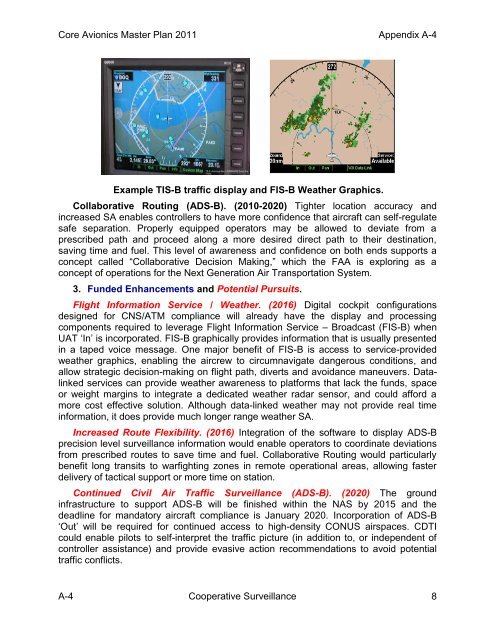
<strong>Core</strong> <strong>Avionics</strong> <strong>Master</strong> <strong>Plan</strong> 2011 Appendix A-4Example TIS-B traffic display and FIS-B Weather Graphics.Collaborative Routing (ADS-B). (2010-2020) Tighter location accuracy andincreased SA enables controllers to have more confidence that aircraft can self-regulatesafe separation. Properly equipped operators may be allowed to deviate from aprescribed path and proceed along a more desired direct path to their destination,saving time and fuel. This level of awareness and confidence on both ends supports aconcept called “Collaborative Decision Making,” which the FAA is exploring as aconcept of operations for the Next Generation Air Transportation System.3. Funded Enhancements and Potential Pursuits.Flight Information Service / Weather. (2016) Digital cockpit configurationsdesigned for CNS/ATM compliance will already have the display and processingcomponents required to leverage Flight Information Service – Broadcast (FIS-B) whenUAT „In‟ is incorporated. FIS-B graphically provides information that is usually presentedin a taped voice message. One major benefit of FIS-B is access to service-providedweather graphics, enabling the aircrew to circumnavigate dangerous conditions, andallow strategic decision-making on flight path, diverts and avoidance maneuvers. Datalinkedservices can provide weather awareness to platforms that lack the funds, spaceor weight margins to integrate a dedicated weather radar sensor, and could afford amore cost effective solution. Although data-linked weather may not provide real timeinformation, it does provide much longer range weather SA.Increased Route Flexibility. (2016) Integration of the software to display ADS-Bprecision level surveillance information would enable operators to coordinate deviationsfrom prescribed routes to save time and fuel. Collaborative Routing would particularlybenefit long transits to warfighting zones in remote operational areas, allowing fasterdelivery of tactical support or more time on station.Continued Civil Air Traffic Surveillance (ADS-B). (2020) The groundinfrastructure to support ADS-B will be finished within the NAS by 2015 and thedeadline for mandatory aircraft compliance is January 2020. Incorporation of ADS-B„Out‟ will be required for continued access to high-density CONUS airspaces. CDTIcould enable pilots to self-interpret the traffic picture (in addition to, or independent ofcontroller assistance) and provide evasive action recommendations to avoid potentialtraffic conflicts.A-4 Cooperative Surveillance 8