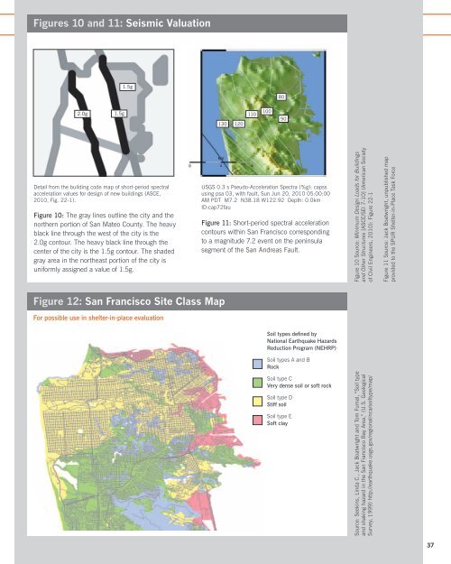
<strong>Safe</strong> <strong>Enough</strong> <strong>to</strong> <strong>Stay</strong>Appendix IIEstablishing a pre-earthquakeshelter-in-place evaluationengineering st<strong>and</strong>ard:Technical considerationsThis appendix provides the technical background <strong>to</strong> support therecommendations made in Section II of this report. In order <strong>to</strong>establish a pre-earthquake shelter-in-place evaluation engineeringst<strong>and</strong>ard, we have recommended making use of the nationalst<strong>and</strong>ard titled “Seismic Evaluation of Existing Buildings,” 38 alsoknown as ASCE 31.To determine, whether a building has shelter-in-place capacity,the ASCE 31 criteria should be modified <strong>to</strong> consider only damagepatterns critical <strong>to</strong> shelter-in-place capacity with reference <strong>to</strong>approved maps of relevant hazards <strong>and</strong> expected infrastructureperformance.We have recommended that the ASCE 31 hazard level be reducedby an appropriate fac<strong>to</strong>r (we recommend 0.6 as a starting placefor discussion) <strong>to</strong> account for the differences between the st<strong>and</strong>ard<strong>and</strong> SPUR’s scenario of interest (i.e., the expected earthquake). Thederivation of this fac<strong>to</strong>r is explained in further detail below.Defining the shelter-in-place hazard level: adjustmentfac<strong>to</strong>r for code-based MCE hazardAs noted in Section II, we recommend the use of seismic hazardparameters given by the building code for new construction <strong>and</strong> usedby ASCE 31, reduced by an appropriate fac<strong>to</strong>r. The code’s parameters(referred <strong>to</strong> as the Maximum Considered <strong>Earthquake</strong> or MCE) arefamiliar <strong>to</strong> engineers <strong>and</strong> code officials, <strong>and</strong> their use avoids theconceptual error of applying a single scenario hazard (which is goodfor citywide planning) <strong>to</strong> individual properties.The adjustment fac<strong>to</strong>r should be developed by the city through aconsensus process as it confirms its resilience objective. In concept,the fac<strong>to</strong>r should be based on a comparison of the code’s spectralacceleration parameters (the quantities most often used by engineers<strong>to</strong> set the size of the design earthquake) <strong>to</strong> those estimated for thescenario or hazard of interest.For example, consider Figures 10 <strong>and</strong> 11. Figure 10 is a detail fromthe building code map showing short-period spectral accelerationvalues in San Francisco. The values range from 1.5g <strong>to</strong> 2.0g formost of the city, including a uniform 1.5g value for the east side <strong>and</strong>38 Seismic Evaluation of Existing Buildings [ASCE/SEI 31-03] (AmericanSociety of Civil Engineers, 2003).northeast quadrant. 39 (Engineers define the lateral acceleration fromearthquake shaking by comparing it <strong>to</strong> the vertical acceleration due<strong>to</strong> gravity, or “g.” Thus, 2.0g, or 200 percent g, means twice theacceleration of gravity.) Figure 11 is a map of spectral accelerationscorresponding <strong>to</strong> the magnitude 7.2 San Andreas scenario earthquakecontemplated in SPUR’s proposed resilience objective. 40A rough comparison of Figures 10 <strong>and</strong> 11 finds that the scenariovalues (Figure 11) are about 60 percent as large as the code values(Figure 10). Code values were computed for 22 locations wherethe Figure 11 con<strong>to</strong>urs cross the street grid. For these locations,the average ratio between the SPUR scenario accelerations <strong>and</strong> thecode values is about 0.57. Adding one st<strong>and</strong>ard deviation (0.02)suggests an appropriately conservative fac<strong>to</strong>r of 0.6. (Indeed, giventhe uncertainties involved in the scenario map, a fac<strong>to</strong>r with only onesignificant figure is warranted.) Again, however, no specific fac<strong>to</strong>r isrecommended here. Rather, this approach is suggested as a simplebut appropriate way of adjusting the ASCE 31 criteria <strong>to</strong> suit a citydefinedresilience objective. A similar study is recommended <strong>to</strong> adjustthe ASCE 31 1-second spectral acceleration values.Additional notes regarding seismicity <strong>and</strong> the definedseismic hazard:• Effects other than shaking — frequency content, duration ofshaking, follow-on shaking due <strong>to</strong> aftershocks, etc. — mightaffect the details of performance but are beyond the scope ofconventional engineering practice <strong>and</strong> are thus beyond the scopeof the shelter-in-place evaluation effort.• Tsunami run-up can be mapped but is not recommended forconsideration as part of the shelter-in-place evaluation criteriabecause tsunami effects can be related <strong>to</strong> distant earthquakes <strong>and</strong>are not expected <strong>to</strong> be significant for the magnitude 7.2 scenario.• Even with a fac<strong>to</strong>r of 0.6 applied <strong>to</strong> the code parameters, theresulting values anywhere within San Francisco would still qualifyas “high” seismicity by ASCE 31 Table 2-1, so the ASCE 31 highseismicity procedures will still apply.Accounting for the effects of local soilsSome ASCE 31 provisions require the determination of site class.Site class is the code term for soil type, from hard rock <strong>to</strong> soft clay.To avoid the cost of geotechnical investigation, we recommendallowing the use of a DBI-approved map based either on investigationreports approved for previous projects or on research such as thatreflected by the map in Figure 12. We also recommend allowing theassumption of Site Class E in areas where the city normally requiresinvestigation for new construction projects; this is consistent with theallowance in ASCE 31 Section 3.5.2.3.1 for Tier 1 evaluation.39 Minimum Design Loads for Buildings <strong>and</strong> Other Structures [ASCE/SEI 7-10](American Society of Civil Engineers, 2010): Figure 22-1.40 Boatwright, J., “USGS 0.3 s Pseudo-Acceleration Spectra (%g): capss usingpsa 03, with fault,” unpublished map provided <strong>to</strong> the SPUR Shelter in Place TaskForce, September 2011.36 SPUR Report > January 2012
Figures 10 <strong>and</strong> 11: Seismic Valuation1.5g802.0g1.5g13012011010010090Detail from the building code map of short-period spectralacceleration values for design of new buildings (ASCE,2010, Fig. 22-1).Figure 10: The gray lines outline the city <strong>and</strong> thenorthern portion of San Mateo County. The heavyblack line through the west of the city is the2.0g con<strong>to</strong>ur. The heavy black line through thecenter of the city is the 1.5g con<strong>to</strong>ur. The shadedgray area in the northeast portion of the city isuniformly assigned a value of 1.5g.USGS 0.3 s Pseudo-Acceleration Spectra (%g): capssusing psa 03, with fault, Sun Jun 20, 2010 05:00:00AM PDT M7.2 N38.18 W122.92 Depth: 0.0kmID:cap72fauFigure 11: Short-period spectral accelerationcon<strong>to</strong>urs within San Francisco corresponding<strong>to</strong> a magnitude 7.2 event on the peninsulasegment of the San Andreas Fault.Figure 10 Source: Minimum Design Loads for Buildings<strong>and</strong> Other Structures [ASCE/SEI 7-10] (American Societyof Civil Engineers, 2010): Figure 22-1Figure 11 Source: Jack Boatwright, unpublished mapprovided <strong>to</strong> the SPUR Shelter-in-Place Task ForceFigure 12: San Francisco Site Class MapFor possible use in shelter-in-place evaluationSoil types defined byNational <strong>Earthquake</strong> <strong>Hazards</strong>Reduction <strong>Program</strong> (NEHRP)Soil types A <strong>and</strong> BRockSoil type CVery dense soil or soft rockSoil type DStiff soilSoil type ESoft claySource: Seekins, Linda C., Jack Boatwright <strong>and</strong> Tom Fumal, “Soil type<strong>and</strong> shaking hazard in the San Francisco Bay Area,” (U.S. GeologicalSurvey, 1999) http://earthquake.usgs.gov/regional/nca/soiltype/map/SPUR Report > January 2012 37