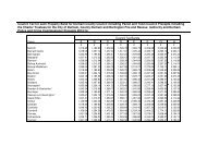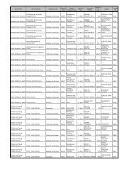
SECTION 3.0 - Durham County Council
SECTION 3.0 - Durham County Council
SECTION 3.0 - Durham County Council

You also want an ePaper? Increase the reach of your titles
YUMPU automatically turns print PDFs into web optimized ePapers that Google loves.
comprising non-statutory sites of county importance (Local Wildlife Sites). There<br />
are also a number of designated SPA’s (Special Protection Areas) and SAC’s<br />
(Special<br />
Areas of Conservation) together with 3 National Nature Reserves<br />
(NNR’s).<br />
Dales Fringe<br />
The river Tees forms the most important natural feature in this character area,<br />
and<br />
is also the most important contribution to biodiversity. Ancient and semi-natural<br />
woodlands of ash and oak are found along the steep valley sides, with scattered<br />
conifer plantations in the upland fringes. The majority of the area is enclosed with<br />
only small areas of open moorland, which are important agriculturally unimproved<br />
refuges especially for moorland birds. Farming and forestry are the<br />
main land use<br />
types<br />
in this area, and there is significant scope for large-scale habitat<br />
improvements.<br />
There is one designated SSSI, and a number of Local Wildlife<br />
Sites.<br />
East <strong>Durham</strong> Limestone Plateau<br />
The <strong>Durham</strong> Magnesian Limestone Natural Area (DMLNA) covers just over 44<br />
000ha of southeast Tyne and Wear, and east <strong>Durham</strong>. It is dominated by<br />
underlying Permian Magnesian Limestone, which exerts a strong influence on soil<br />
types and vegetation communities. The area is dominated by arable farmland and<br />
pasture, but a number of semi-natural wildlife habitats do remain. The key habitat<br />
feature is the unimproved magnesian limestone grassland, a nationally rare habitat<br />
type. Almost two thirds of all magnesian limestone grassland in Britain is found in<br />
the DMLNA. Calcareous grassland and basic mires occur along the <strong>Durham</strong> coast<br />
and abandoned limestone quarries are colonised by typical limestone flora. Small<br />
areas of unimproved neutral grassland also occur within this area with scattered<br />
ancient semi-natural woodlands, which are centred in the denes of the coastal<br />
plateau and on steeper slopes of the escarpment. Due to the remarkable ecology<br />
and geological interest of the DMLNA there are a number of designated sites,<br />
including 4 NNR’s, around 48 SSSI’s and a number of Local Wildlife Sites. The<br />
area also contains a number of Geological/Geomorphological SSSI’s as well as<br />
county Geological/Geomorphological Sites.<br />
T ees Lowlands<br />
This character area comprises the River Tees estuary, and its associated low-lying<br />
land. The area is framed by the Cleveland Hills and the North York Moors to the<br />
South, the east <strong>Durham</strong> plateau to the north, and the foothills of the Pennines to<br />
the west. The North Sea, Tees Bay and the river estuary make up its eastern<br />
boundary. There has been considerable reclamation of the Tees estuarine habitats<br />
but<br />
remnants exist an constitute the Teesmouth flats and marshes NCR sites,<br />
characterised by mud flats, salt marsh, grazing marsh, sand dunes, open water<br />
and wetlands. There are two designated SSSI’s, both wetlands, and a small<br />
Page 31 4/15/2009