GIS Worksheet 4a - Pearson Australia Media Resources
GIS Worksheet 4a - Pearson Australia Media Resources
GIS Worksheet 4a - Pearson Australia Media Resources

You also want an ePaper? Increase the reach of your titles
YUMPU automatically turns print PDFs into web optimized ePapers that Google loves.
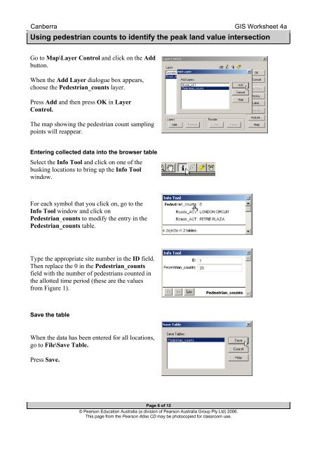
Canberra<strong>GIS</strong> <strong>Worksheet</strong> <strong>4a</strong>Using pedestrian counts to identify the peak land value intersectionGo to Map\Layer Control and click on the Addbutton.When the Add Layer dialogue box appears,choose the Pedestrian_counts layer.Press Add and then press OK in LayerControl.The map showing the pedestrian count samplingpoints will reappear.Entering collected data into the browser tableSelect the Info Tool and click on one of thebusking locations to bring up the Info Toolwindow.For each symbol that you click on, go to theInfo Tool window and click onPedestrian_counts to modify the entry in thePedestrian_counts table.Type the appropriate site number in the ID field.Then replace the 0 in the Pedestrian_countsfield with the number of pedestrians counted inthe allotted time period (these are the valuesfrom Figure 1).Save the tableWhen the data has been entered for all locations,go to File\Save Table.Press Save.Page 6 of 12© <strong>Pearson</strong> Education <strong>Australia</strong> (a division of <strong>Pearson</strong> <strong>Australia</strong> Group Pty Ltd) 2006.This page from the <strong>Pearson</strong> Atlas CD may be photocopied for classroom use.