GIS Worksheet 4a - Pearson Australia Media Resources
GIS Worksheet 4a - Pearson Australia Media Resources
GIS Worksheet 4a - Pearson Australia Media Resources

You also want an ePaper? Increase the reach of your titles
YUMPU automatically turns print PDFs into web optimized ePapers that Google loves.
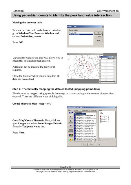
Canberra<strong>GIS</strong> <strong>Worksheet</strong> <strong>4a</strong>Using pedestrian counts to identify the peak land value intersectionViewing the browser tableTo view the data table in the browser window,go to Window\New Browser Window andchoose Pedestrian_counts.Press OK.Viewing the windows in this way allows you tocheck that all data has been entered.Additions can be made to the browser ifrequired.Close the browser when you are sure that alldata has been added.Step 4: Thematically mapping the data collected (mapping point data)The data can be mapped using symbols that range in size according to the number of pedestrianscounted. There are different ways of doing this.Create Thematic Map—Step 1 of 3Go to Map\Create Thematic Map, click ontype Ranges and select Point Ranges Defaultfrom the Template Name list.Press Next.Page 7 of 12© <strong>Pearson</strong> Education <strong>Australia</strong> (a division of <strong>Pearson</strong> <strong>Australia</strong> Group Pty Ltd) 2006.This page from the <strong>Pearson</strong> Atlas CD may be photocopied for classroom use.