Hydrogeological mapping as a basis for establishing site-specific ...
Hydrogeological mapping as a basis for establishing site-specific ...
Hydrogeological mapping as a basis for establishing site-specific ...
- No tags were found...

You also want an ePaper? Increase the reach of your titles
YUMPU automatically turns print PDFs into web optimized ePapers that Google loves.
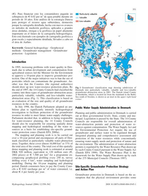
(e). Para financiar esto los consumidores pagarµn unsobreprecio de e 0.02 por m 3 de agua potable durante unperiodo de 10 aæos. Este anµlisis de la estrategia Danesapara proteger el recurso agua subterrµnea, demuestraporque la cartografía detallada, hecha con nuevos avancesen mØtodos de medición geofísica, aplicados a grandesµre<strong>as</strong> aledaæ<strong>as</strong>, otorgan a la geofísica un papel altamenteimportante en el futuro de la cartografía hidrogeológica.Esto estµ ilustrado con ejemplos de cartografía geofísica agran escala y espacialmente detallada, llevados a cabo enel µrea de Aarhus.551Keywords General hydrogeology · Geophysicalmethods · Groundwater management · Groundwaterprotection · LegislationIntroductionIn 1995, incre<strong>as</strong>ing problems with water quality in Denmarkdue to urban development and contamination fromagricultural sources led the Minister <strong>for</strong> the Environmentto approve a 10-point plan to improve groundwater protection.One of the major initiatives w<strong>as</strong> to ban the use ofpesticides which can contaminate the groundwater. Anotherw<strong>as</strong> that the Counties (the regional authorities)should draw up new water-resource protection plans. Bythe end of 1997, the 14 County Councils had cl<strong>as</strong>sified thecountry into three types of groundwater-abstraction are<strong>as</strong>:particularly valuable, valuable, and less-valuable waterabstractionare<strong>as</strong> (Fig. 1). This cl<strong>as</strong>sification is b<strong>as</strong>ed onan evaluation of the size and quality of all groundwaterresources in the country.In July 1998, the Danish Parliament adopted an ambitiousplan to significantly intensify hydrogeologicalinvestigation to facilitate protection of the groundwaterresource in order to meet future water-supply challenges.Parliament decided that, in addition to being responsible<strong>for</strong> water-resource planning, the 14 County Councilsshould also be responsible <strong>for</strong> ensuring spatially dense<strong>mapping</strong> and hydrological modelling of the water resources<strong>as</strong> a b<strong>as</strong>is <strong>for</strong> <strong>establishing</strong> <strong>site</strong>-<strong>specific</strong> groundwaterprotection zones (Danish EPA 2000a).The <strong>mapping</strong> and planning work is to be carried outover a 10-year period and encomp<strong>as</strong>ses all parts of Denmarkcl<strong>as</strong>sified <strong>as</strong> particularly valuable water-abstractionare<strong>as</strong>. Together, these cover almost 16,000 km 2 or 37% ofthe total area of the country. The total cost of this spatiallydense <strong>mapping</strong> and planning work is estimated at aroundDKK 920 million, equivalent to 120 million euro (e,2002 prices) or e 7,500 per km 2 <strong>for</strong> a programme encomp<strong>as</strong>singgeophysical profiling every 250 m, surveydrilling every 4 km 2 , water sampling and hydrologicalmodelling. During the 10-year <strong>mapping</strong> and planningperiod, Danish consumers have to pay the County Councilsa e 0.02 surcharge per m 3 of water consumed, i.e.about e 4 per family per year.Hydrogeology Journal (2004) 12:550–562Fig. 1 Groundwater cl<strong>as</strong>sification map showing subdivision ofDenmark into particularly valuable, valuable and less-valuablegroundwater-abstraction are<strong>as</strong> in 2001. The Danish island Countyof Bornholm, which is located far from the mainland in the BalticSea south of Sweden, is shown <strong>as</strong> an inset in the upper right-handcornerPublic Water Supply Administration in DenmarkPlanning and public administration in Denmark is carriedout at three governmental levels: State, county and municipal.Legislation is p<strong>as</strong>sed by the State. The 14 CountyCouncils are responsible <strong>for</strong> overall administration ofwater-abstraction permits and protection of water resourcesagainst contamination. The Water Supply Act andthe Environmental Protection Act require the use ofgroundwater and surface water to be regulated throughintegrated planning and comprehensive <strong>as</strong>sessment andprotection of the water resources while concomitantlyensuring water-supply needs and protection of nature andthe environment. The administration of water-abstractionpermits is regulated by the Water Resource Plan drawn upby each County Council pursuant to the Water Supply Act(Danish EPA 1999). The Water Resource Plan is theframework <strong>for</strong> the Water Supply Plan drawn up by eachof the 275 Municipal Councils (Thomsen 1997).Site-Specific Groundwater Protection Strategyand Action PlanGroundwater protection in Denmark is b<strong>as</strong>ed on the <strong>as</strong>sumptionthat the physical environment provides someDOI 10.1007/s10040-004-0345-1